|
Brian Posts: 221
4/1/2021
|
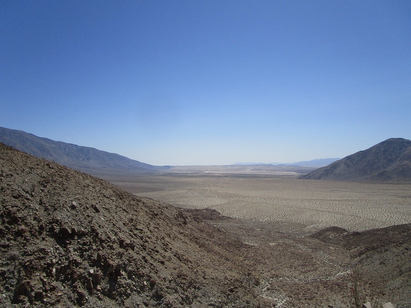
That feeling when your waypoint is only a half mile away but you realize it's on the other side of a canyon that looks like this. "You descend the ridge you have, not the ridge you wish you had." I may be slightly misquoting someone.


|
|
|
+3
link
|
|
Rocko1 Posts: 588
4/2/2021
|
That's quite a ridge to scramble up!
|
|
|
link
|
|
deborah Posts: 113
4/2/2021
|
Oh that's great! I chuckled reading it. It reminds me of those internal debates, like "this downclimb can't be that bad?" when you know the alternative is a long backtrack...
Where is this?
|
|
|
+1
link
|
|
Brian Posts: 221
4/2/2021
|
deborah: the bottom is BM "Corp" in Clark Valley. The far ridge in the pics (the one I had intended to go down but didn't) is the ridge that Schad recommends for an approach to Dawn's Peak.
There were probably better ways to descend the ridge I was on, but I started seeing cairns, so I figured at least someone had done my route before.
|
|
|
link
|
|
deborah Posts: 113
4/2/2021
|
Thanks Brian, I thought that's where it was but wasn't quite sure.
It's a great area to explore. Sometimes I follow Schad's approach, then meander back via Rockhouse Canyon. I have yet to do the climb to Dawn's Peak though. Maybe this year. 
|
|
|
link
|
|
Brian Posts: 221
4/2/2021
|
That's basically what I was doing, but in reverse. I need to work on my cardio before I can attempt anything like Dawn's.
|
|
|
link
|
|
Buford Posts: 453
4/2/2021
|
Did you actually find the Corp BM? When I did 6582 a couple years ago we couldn't find the BM but didn't spend too much time looking. The rock art was easy enough to find.
The ridges in that area sure are steep.
--
Links to my photos: ABDSP photos, Bighorn sheep photos, ABDSP time lapse video, Wildlife photos (mainly birds)
|
|
|
link
|
|
dsefcik Administrator Posts: 2609
4/2/2021
|
Brian wrote:
That feeling when your waypoint is only a half mile away but you realize it's on the other side of a canyon that looks like this.
Hey Brian, good to meet you in person!
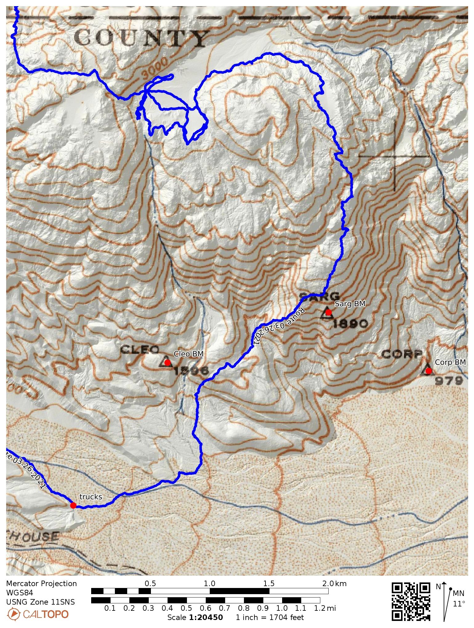
Brian managed to run across Gary and myself up in the flat before this downhill. Gary and I took the finger to the right in this photo and then stayed way right to come down almost straight in line with the trucks parked at Butler junction.
Gary and I backpacked for 7 days in Rockhouse Canyon and on our last day we were up in that flat when we ran into Brian.
--
http://www.sefcik.com
http://www.darensefcik.com
http://www.carrizogorge.com
|
|
|
link
|
|
dsefcik Administrator Posts: 2609
4/2/2021
|
deborah wrote:
"this downclimb can't be that bad?" when you know the alternative is a long backtrack...
Gary said to me once when we were climbing up a long access road to Rogers peak in Death Valley that was all up and zero down, "I ain't seen a single downhill going up this hill"
--
http://www.sefcik.com
http://www.darensefcik.com
http://www.carrizogorge.com
|
|
|
link
|
|
Brian Posts: 221
4/2/2021
|
dsefcik wrote:
Gary and I took the finger to the right in this photo and then stayed way right to come down almost straight in line with the trucks parked at Butler junction.
So that's how you beat me back to the car! When I looked at google earth after I got home I could see that would have been a better route than what I did. I saw some cairns leading down toward the deep canyon and followed them. It was a wild ride.
It was great meeting you and Gary too. The best part of my day in fact.
|
|
|
link
|
|
Brian Posts: 221
4/2/2021
|
Buford wrote:
Did you actually find the Corp BM? When I did 6582 a couple years ago we couldn't find the BM but didn't spend too much time looking. The rock art was easy enough to find.
The ridges in that area sure are steep.
I went right by the waypoint I had saved for Corp but I didn't look for it either. I was running low on water and ready to be done at that point.
|
|
|
link
|
|
rockhopper Posts: 668
4/4/2021
|
Brian wrote:
Buford wrote:
Did you actually find the Corp BM? When I did 6582 a couple years ago we couldn't find the BM but didn't spend too much time looking. The rock art was easy enough to find.
The ridges in that area sure are steep.
I went right by the waypoint I had saved for Corp but I didn't look for it either. I was running low on water and ready to be done at that point.[/quote
Looks like your hiking poles were adjusted on full short during the ascent and full long during the decent. I would need to use my big horn sheep hiking skills on those slopes.
edited by rockhopper on 4/4/2021
|
|
|
link
|
|
dsefcik Administrator Posts: 2609
4/5/2021
|
Brian wrote:
dsefcik wrote:
Gary and I took the finger to the right in this photo and then stayed way right to come down almost straight in line with the trucks parked at Butler junction.
So that's how you beat me back to the car! When I looked at google earth after I got home I could see that would have been a better route than what I did. I saw some cairns leading down toward the deep canyon and followed them. It was a wild ride.
Here is the route we took down:
--
http://www.sefcik.com
http://www.darensefcik.com
http://www.carrizogorge.com
|
|
|
link
|
|
dsefcik Administrator Posts: 2609
4/5/2021
|
Brian wrote:
There were probably better ways to descend the ridge I was on, but I started seeing cairns, so I figured at least someone had done my route before. Unfortunately there are too many misc cairns out there, many of them only indicate someone else has gone that direction *at least once*. While they can be helpful in many routes I would not suggest following them if they do not seem like they are taking you in the right direction. One of the things I like about the desert is you can generally just head the direction you want to go and find a route.
--
http://www.sefcik.com
http://www.darensefcik.com
http://www.carrizogorge.com
|
|
|
link
|
|
Brian Posts: 221
4/5/2021
|
dsefcik wrote:
Unfortunately there are too many misc cairns out there, many of them only indicate someone else has gone that direction *at least once*. While they can be helpful in many routes I would not suggest following them if they do not seem like they are taking you in the right direction. One of the things I like about the desert is you can generally just head the direction you want to go and find a route.
I also chose the route I did because I could see from where I was that it was a viable route all the way to the bottom. Ironically, this means that by trying to play it safe I was going down a steeper route than if I had trusted the topo map. I'm still pretty new to going places that aren't well-used routes and this trip was a good reminder that I need to get better at topo map skills.
|
|
|
link
|
|
Brian Posts: 221
11/26/2023
|
dsefcik wrote:
Here is the route we took down:

I always meant to revisit this and try this alternate route (for 2.5 years now I guess? Time flies). I finally did it. I figured this would be one of the few places in Anza Borrego that wouldn't have a crowd on a Thanksgiving weekend. I did the route in reverse, climbing from the parking area to BM Sarg, then working my way over to the ridge that people use as an approach to Dawn's and I descended that to Clark Valley. 9 mile loop / 9 hours hiking / endless rock hopping.
I'm happy to report that Rockhouse Road is still passable in a Subaru as far as the Butler junction. I was expecting much worse considering that Hillary apparently wiped out a good chunk of Coyote Canyon Road.
|
|
|
+1
link
|
|
deborah Posts: 113
11/27/2023
|
Brian wrote:
I'm happy to report that Rockhouse Road is still passable in a Subaru as far as the Butler junction. I was expecting much worse considering that Hillary apparently wiped out a good chunk of Coyote Canyon Road.
Thanks for that info! I'm glad to hear the road is passable. I was out there during the storm, and Clark Lake (with actual water) had slightly submerged a part of the jeep trail for a bit.
|
|
|
link
|