|
tommy750 Posts: 1040
3/14/2023
|
Haven't been up Whale in quite a while but always wanted to explore the flats to the east and southeast. Figured I'd try the Bisnaga Alta route, a southern approach I first head about on this forum when Daren did it in 10/2011. Unfortunately the pics are no longer hosted but Daren sent me his route which was a way tougher loop hike. Googled the route and even looked at the last 50 or so PeakBagger gps entries and zero hits for the Bisnaga route.
 123_1 by tomteske, on Flickr 123_1 by tomteske, on Flickr
Was a cool somewhat cloudy day and very windy near the top. A look back at the Sawtooth spine about two miles up Bisnaga Alta wash.
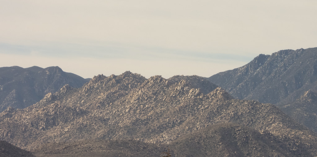 Sawtooth Spine by tomteske, on Flickr Sawtooth Spine by tomteske, on Flickr
Still a little snow on at least the north facing Lagunas.
 Nine Miles Away by tomteske, on Flickr Nine Miles Away by tomteske, on Flickr
Was assuming the route was not that popular but noted fresh vehicles tracks at the Bisnaga turn out and two sets of prints heading up/down the wash maybe the first 3-4 miles. At about mile 3, a third set of prints appeared. Here they are with better lighting on the descent, size 14 boots for scale. Not sure where the two hikers went but didn't see anymore of their prints.
 IMG_2979 by tomteske, on Flickr IMG_2979 by tomteske, on Flickr
 IMG_2982 by tomteske, on Flickr IMG_2982 by tomteske, on Flickr
Nice succulent.
 IMG_2923 by tomteske, on Flickr IMG_2923 by tomteske, on Flickr
Thought I spotted a native trail heading out of the flat above Bisnaga Alta on GE and maybe found bits of it. Here's a rather well preserved section.
 IMG_2945 by tomteske, on Flickr IMG_2945 by tomteske, on Flickr
The view toward the flat.
 IMG_2942 by tomteske, on Flickr IMG_2942 by tomteske, on Flickr
Found a dozen or so roasting pits on the way up and with the sun fading, kinda quit counting on the way down. Some are almost easier to see on GE. Here's RP-8 and the view from space. You can even see the slick on the boulder from the satellite image (red arrow)
 IMG_2949 by tomteske, on Flickr IMG_2949 by tomteske, on Flickr
 RP-8 by tomteske, on Flickr RP-8 by tomteske, on Flickr
Another roasting pit a bit farther up.
 IMG_2952 by tomteske, on Flickr IMG_2952 by tomteske, on Flickr
 RP-10 by tomteske, on Flickr RP-10 by tomteske, on Flickr
At the top there were a lot of downer trees looking like they'd been ripped out of the ground and tossed presumably by some ferocious winds.
 IMG_2954 by tomteske, on Flickr IMG_2954 by tomteske, on Flickr
Explored around one of the flats and found a couple rock shelters with cultural stuff. Nice mortero and pestle.
 IMG_2956 by tomteske, on Flickr IMG_2956 by tomteske, on Flickr
Didn't spend as much time as I'd hoped exploring the flats since I wanted to get down to the wash before dark. Here's a historical .50 cal artifact a long way from the Carrizo Impact Area.
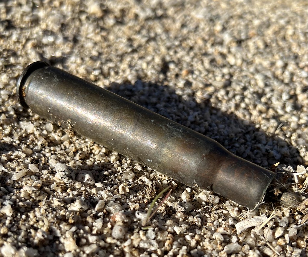 IMG_2973 by tomteske, on Flickr IMG_2973 by tomteske, on Flickr
 IMG_2974 by tomteske, on Flickr IMG_2974 by tomteske, on Flickr
A little less that 13 miles and about 3700 ft g/l. Another nice day in the desert. Enjoy!
 IMG_2984 by tomteske, on Flickr IMG_2984 by tomteske, on Flickr
|
|
|
+2
link
|
|
ziphius Posts: 911
3/14/2023
|
Good-looking trip Tom. That pestle is the largest I've seen out there. I miss the Sawtooth spine, spent the better part of a day kicking around up there once. Amazing what you can detect for confirm from satellite imagery. Once saw two bighorn rams side by side, drinking at a guzzler on satellite.
--
http://www.coyotelearning.org
|
|
|
+1
link
|
|
Rocko1 Posts: 588
3/15/2023
|
Very nice! Can you explain how a roasting pit differs from say a plain old clearing? I have come across many areas that are cleared of most plant life and rocks but was never sure if was by chance or a real pit.
|
|
|
link
|
|
surfponto Administrator Posts: 1362
3/15/2023
|
Some beautiful desert backcountry. Looks like you had great weather
--
https://www.anzaborrego.net/


|
|
|
+1
link
|
|
Brian Posts: 221
3/15/2023
|
That's an ambitious route for a dayhike. I love seeing reports of routes that are rarely visited. Nice to know there are a few of those left.
|
|
|
+1
link
|
|
Bob S Posts: 7
3/15/2023
|
Lake City 1971
--
Big Sandy Shooter
|
|
|
link
|
|
tommy750 Posts: 1040
3/15/2023
|
ziphius wrote:
Good-looking trip Tom. That pestle is the largest I've seen out there. I miss the Sawtooth spine, spent the better part of a day kicking around up there once. Amazing what you can detect for confirm from satellite imagery. Once saw two bighorn rams side by side, drinking at a guzzler on satellite.
I still remember your pic of the two sheep! That was a nice find.
|
|
|
link
|
|
tommy750 Posts: 1040
3/15/2023
|
surfponto wrote:
Some beautiful desert backcountry. Looks like you had great weather
Was nice and cool but a speck breezy for my taste. Still went through 3 liters.
|
|
|
+1
link
|
|
tommy750 Posts: 1040
3/15/2023
|
Brian wrote:
That's an ambitious route for a dayhike. I love seeing reports of routes that are rarely visited. Nice to know there are a few of those left.
Definitely like backpacking for that reason, much more loiter time to explore since no pressure to get back home.
|
|
|
link
|
|
tommy750 Posts: 1040
3/15/2023
|
Rocko1 wrote:
Very nice! Can you explain how a roasting pit differs from say a plain old clearing? I have come across many areas that are cleared of most plant life and rocks but was never sure if was by chance or a real pit.
A roasting pit is going to have fire affected rocks (usually gray/black/sometimes reddish colored) along with ashy soil. They're often on mountain ridges and can be rather pristine or eroded away. If you come upon a nice rock circle of "FAR" filled with a deep layer of ash, it's pretty obvious. Sometimes the rocks are disorganized and the grey ash layer is covered with sediment or overgrown by plants. Have to say my examples of roasting pits are pretty beat up. Daren's trick is to trench the soil layer with your boot heel and see if it reveals the gray soil.
|
|
|
+1
link
|
|
Rocko1 Posts: 588
3/16/2023
|
tommy750 wrote:
Rocko1 wrote:
Very nice! Can you explain how a roasting pit differs from say a plain old clearing? I have come across many areas that are cleared of most plant life and rocks but was never sure if was by chance or a real pit.
A roasting pit is going to have fire affected rocks (usually gray/black/sometimes reddish colored) along with ashy soil. They're often on mountain ridges and can be rather pristine or eroded away. If you come upon a nice rock circle of "FAR" filled with a deep layer of ash, it's pretty obvious. Sometimes the rocks are disorganized and the grey ash layer is covered with sediment or overgrown by plants. Have to say my examples of roasting pits are pretty beat up. Daren's trick is to trench the soil layer with your boot heel and see if it reveals the gray soil.
Perfect. Thank you. I have come across a fair number of these areas on ridges and always thought, why is there no rocks or plants in this specific area? Was it a sleeping location previously, roasting pit, etc. They stick out especially when the adjacent areas are thick with flora.
|
|
|
link
|
|
tekewin Posts: 365
3/16/2023
|
Very impressive trip! I don't think I've seen that route before, but wasn't on the forum back in 2011.
You really have an eye for native artifacts. I'm sure I walk by treasures all the time in complete ignorance.
|
|
|
+1
link
|
|
tommy750 Posts: 1040
3/16/2023
|
tekewin wrote:
Very impressive trip! I don't think I've seen that route before, but wasn't on the forum back in 2011.
You really have an eye for native artifacts. I'm sure I walk by treasures all the time in complete ignorance.
Was a casual weekend peakbagger till stumbling on this forum a decade ago and realizing everyone here had a real curiosity of the fauna/flora/geology/artifacts around them. Seems obvious, but have to say it really changed my perspective. Thanks everyone!
|
|
|
+2
link
|
|
surfponto Administrator Posts: 1362
3/17/2023
|
I am really glad you guys have been utilizing this forum 👍
Also want to thank Daren for helping manage it over the years.
My https://anzaborrego.net domain name will be 20 years old on April 03 and the forum started up in 2009
tommy750 wrote:
tekewin wrote:
Very impressive trip! I don't think I've seen that route before, but wasn't on the forum back in 2011.
You really have an eye for native artifacts. I'm sure I walk by treasures all the time in complete ignorance.
Was a casual weekend peakbagger till stumbling on this forum a decade ago and realizing everyone here had a real curiosity of the fauna/flora/geology/artifacts around them. Seems obvious, but have to say it really changed my perspective. Thanks everyone!
--
https://www.anzaborrego.net/
|
|
|
+1
link
|
|
rockhopper Posts: 668
4/4/2023
|
Nice hike. I always wanted to do the southern route. Thanks for the motivation!
|
|
|
link
|