4/28/2009
Topic:
New lift for the HZJ80 LandCruiser
surfpontoAdministrator
|
I spent the weekend out in Ramona with Mike of West Coast Cruisers. Our goal was to install the 3" OME lift on my new diesel Landcruiser.
Luckily the lift for an 80 series is pretty straight forward and with the two of us working it took us about 4 hours from start to finish.
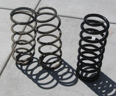
New rear OME spring on right versus stock springs on left. These give the cruiser 3" of lift.
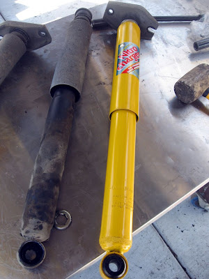
New OME rear shock versus OEM Toyota shocks.

Lift complete. Time to lower Tubbs Jr. Thanks Mike!!
Now we just need to research some tires.
<em>edited by surfponto on 4/28/2009</em> |
4/29/2009
Topic:
Anza Borrego camping in the summer
surfpontoAdministrator
|
Hey Desertman
We once took a trip to the Mud Caves in Arroyo Tapiado during June.
It was hot in the wash but once we got down into the caves the temperature dropped 20'
We didn't camp though , just spent the day. Manageable but definetly in the triple digits 
desertman wrote:
Does anyone ever go out to Anza Borrego to camp in the summer or is it just too hot?
edited by desertman on 4/29/2009 |
5/3/2009
Topic:
Hiking to Goat Canyon Trestle
surfpontoAdministrator
|
Thanks JT.
Haven't done thatr route yet.
Will have to check that out. Is that the one that takes you past Carrizo Palms?
Bob
jt wrote:
Friends hiked along the tracks (illegal, we should point out, because on railroad property) in Dec 07. It's the easiest way to get to the Trestle, but still quite a decent hike. See Jerry Schad's Indian Hill hike in Afoot and Afield--cut across the desert east from end of the road past Dos Cabezas. This cuts off the big northerly loop the tracks take. |
5/3/2009
Topic:
Carrizo Gorge East Fork to Carrizo Palms
surfpontoAdministrator
|
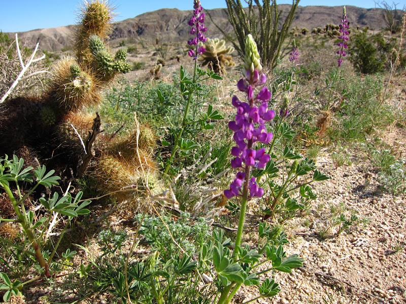
We did a day hike from Carrizo Gorge - East Fork to the Carrizo Palm grove. Awesome hike!! Probably 5 hours round trip but well worth it.
There was a breeze the entire way up which made the hike nice since it was 90' +.
We found at least 5 or 6 backpacks on the way up and back that were obviously left by Mexican immigrants coming up from the border. We were kind of wondering why they ditched them in the canyon?
Here is the post to the entire trip.
<em>edited by surfponto on 5/4/2009</em> |
8/20/2009
Topic:
Anza Borrego camping in the summer
surfpontoAdministrator
|
sunburn wrote:
Hey, new to the place. Great to see some borrego lovers out here. Since about 1986, which was my first camping trip to borrego....the majority of my trips to borrego have been in the middle of summer. Yeah it gets blazing, but you also get your pick of spots...very few people...kind of nice but potentially dangerous. The absolute scariest time was losing the car in Clark Valley after hiking back from the petroglyphs at corp. It was 113 and two of us got sick. Whew....you just cannot overemphasize water.
Hey sunburn.
Welcome to the forum.!!
OK you are hardcore. The only time I have been out to Borrego in the summer was to check out the Mud Caves. It was over 100' out in the open but the temp dropped 20' degrees once you got down inside the caves.
I have been tempted to head out this summer since we have had some real cloudy days on the coast. Have to convince my wife though. 
Would love to hear more about your "losing the car" story.
Bob |
8/20/2009
Topic:
Dual battery kit for the Toyota HZJ80 LandCruiser
surfpontoAdministrator
|
Just finished my dual battery install on our Toyota HZJ80 Landcruiser. I went with the National Luna Split-Charge Kit to isolate the auxillary battery from the starting battery. Kit was a bit expensive but it does include everything you need except for the battery, tray and the 12-volt sockets.
Will post some pics and do a write up soon.
Bob
edited by surfponto on 8/20/2009
<em>edited by surfponto on 8/20/2009</em> |
8/20/2009
Topic:
Dual battery kit for the Toyota HZJ80 LandCruiser
surfpontoAdministrator
|
sunburn wrote:
Do you run a lot of additional electronics?
We have an Engel fridge (MT-45) that we bring on our camping trips.
It is pretty low draw but if we camp in one place for a few days it is nice to know you can run it without killing the starting battery.

Engel MT-45 Review
<em>edited by surfponto on 8/20/2009</em> |
9/16/2009
Topic:
New Camper
surfpontoAdministrator
|
Hi welcome to the forum,
It is a good time of year to head out there. Fall is one of my favorite times. Temperatures are finally starting to cool down. 
It is true you can camp pretty much anywhere in the park.
Main rules to be aware of are fires have to be in a metal container, dogs need to be on a 6' leash and keep your vehicle on the established jeep roads.
If you are going to be near the north end of the park I suggest the Clark Dry Lake bed area which has a lot of room to camp and also some interesting hikes.You can access Butler Canyon, Hidden Spring, and Rockhouse Valley from this area.
Bob
aphilippe wrote:
I am planning on heading out to Anza with friends for the first time next month. We were hoping for some recommendations for camping spots. We are coming from San Diego and plan on staying near central/north Borrego. We would like to stay in one of the "primitive" camping areas but I'm not sure if it is true that you can camp anywhere off the main roads or if there are more rules to it. Any help or recommendations would be great!
<em>edited by surfponto on 9/16/2009</em> |
2/8/2010
Topic:
Hiking to Goat Canyon Trestle
surfpontoAdministrator
|
Hey again,
We did the Mortero Palms route and it was easy to follow with a GPX track I downloaded. Pretty amazing hike.
Probably do it again this year during the Spring.
Goat Canyon Trestle Revisited
Bob
jt wrote:
Friends hiked along the tracks (illegal, we should point out, because on railroad property) in Dec 07. It's the easiest way to get to the Trestle, but still quite a decent hike. See Jerry Schad's Indian Hill hike in Afoot and Afield--cut across the desert east from end of the road past Dos Cabezas. This cuts off the big northerly loop the tracks take.
<em>edited by surfponto on 2/8/2010</em> |
2/8/2010
Topic:
Flower Season 2010
surfpontoAdministrator
|
All indications are showing a really good flower season out in Anza Borrego this year.
We are planning a "scouting trip" this Valentines weekend.
I will report back.
 |
2/8/2010
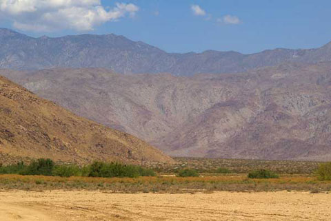
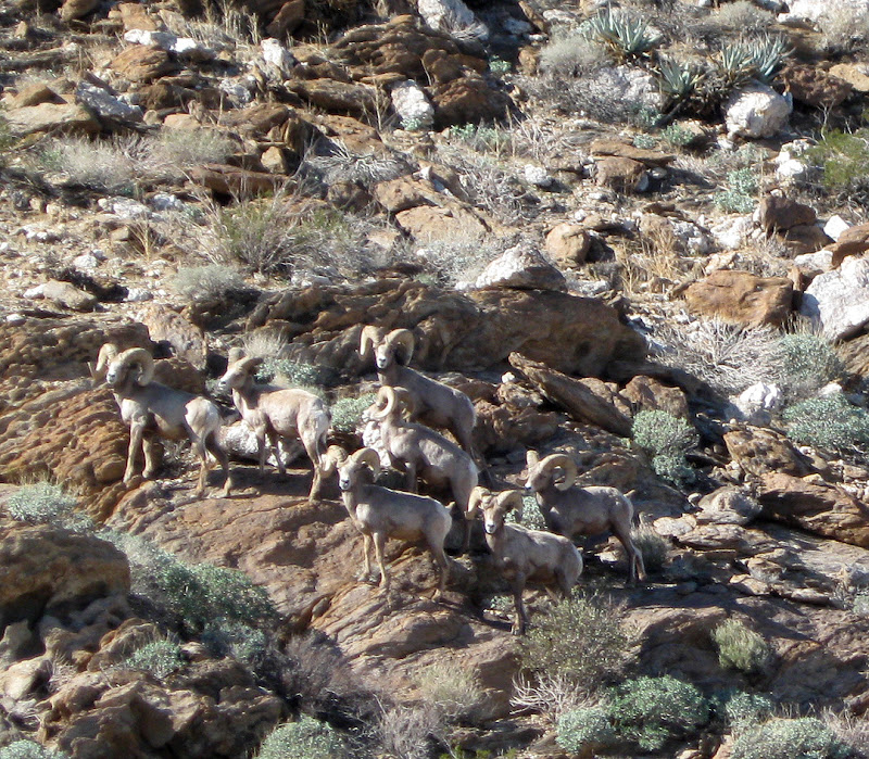
Topic:
Bighorn Sheep Sighting in Anza Borrego
surfpontoAdministrator
|
We had the amazing experience a couple of weeks back of running into a "Bachelor Herd" of Desert Bighorns.
This was close to Indian Hill
 |
2/9/2010
Topic:
Bighorn Sheep Sighting in Anza Borrego
surfpontoAdministrator
|
Hi,
We never did find the railroad camp ruins. We walked N N/W of Indian Hill until we got to the mountian and then followed the stream bed North.
I am thinking of trying again this coming weekend.
Any suggestions?
Thanks,
Bob
hikerdmb wrote:
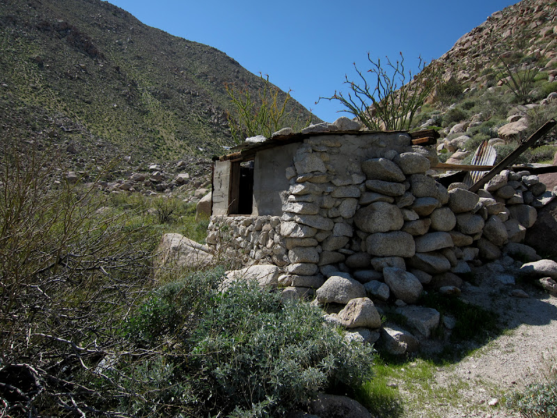
I read your post (somewhere else on this site) about looking for the railroad camp in the Indian Hill area and noticed your pics of the pictographs. Did you find the tank just across from the cave? A short distance up the hill. Was it full of water? Make sure you go back again and search for the camp it is a cool find. There is a shelter that is built with cans. It has a neat feeling to walk around and know how many people were there and working on the tracks. |
2/9/2010
Topic:
Bighorn Sheep Sighting in Anza Borrego
surfpontoAdministrator
|
Thanks.
Yeah I am the one that does this site.
It started out as a photo album thing back in 2002 and then kind of grew. Still kind of small though.
I do know that ridge you are talking about. We stayed on the east side last trip which was the problem.
I would love to get a copy of the map so I will PM you.
We are going to head out Saturday morning and probably hit the Mud Caves in Arroyo Tapiado also.
Thanks,
Bob
hikerdmb wrote:
I tried to attach a scanned copy of the map of that area. But the site would not let me attach anything over 15kb and that didn't work so well. If you have an old Sweeny Pass topo map that would help. If not, try going a bit more northwest from the cave toward a ridge that runs north south. The tracks are on the west side of this ridge. The camp is in a fairly flat area a very short distance south and east from the south end of that ridge and north of the jeep road. This is all from memory from a bunch of years ago. First time in that area we went from Mortero Palms over the mountains to Goat Canyon and then followed the tracks north through Indian Hill area and back to the truck. NO trains were running then so we went through all the tunnels except I think one was totally caved in. Have since backpacked in a couple of times and day hiked in a couple of times to the Indian Hill area. If you want to PM me I can send you a larger than 15 kb scan of the map with a big X where I remember the camp being located.
David
By the way are the guy who has been putting up reports and running this site for the last couple of years?
<em>edited by surfponto on 2/9/2010</em> |
2/9/2010
Topic:
Flower Scouting trip
surfpontoAdministrator
|
Sounds like it is a go for this weekend. (2/13 - 2/14)
Convinced my wife to head out Saturday to check for flowers. We will camp out Saturday night and possibly check out the Mud Caves on Sunday.
If anyone else is heading out , let me know. |
2/15/2010
Topic:
Rainbow Wash
surfpontoAdministrator
|
Awesome trip report !
Appreciate the flower update. We were in the Southern end of Anza Borrego and pretty much the same. Some Ocotillo blooms but not many flowers. Some of the Chuparosa bushes were beginning to flower also
I am going to add a post tomorrow with some pics.

By the way your scanned map was crucial in helping us find the Railroad camp.
Thanks so much.
Bob
<em>edited by surfponto on 2/15/2010</em> |
2/16/2010
Topic:
Rainbow Wash
surfpontoAdministrator
|
It was pretty much dead on.
I was able to look at the topo elevations and from that add a waypoint to my GPS.
Worked perfectly.
Bob
hikerdmb wrote:
Glad you found the camp. Just curious though, how close was my X on the map to the actual location? I think it has been close to 10 years since I was there. |
2/16/2010
Topic:
Rainbow Wash
surfpontoAdministrator
|
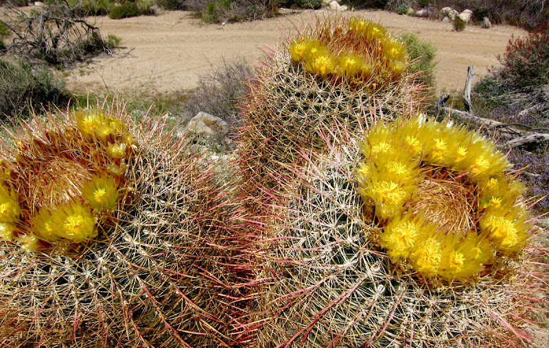
Lots of green Ocotillo with orange blooms everywhere
A few barrel cacti with yellow buds.
I am thinking in 2-3 weeks it could be really nice.
hikerdmb wrote:
Glad you found it so easily and can't wait to see what the southern part of the park is like. I was down there 3 weeks ago and am curious to see how it has changed since then. |
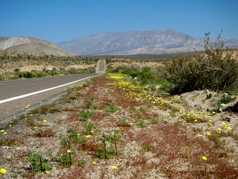
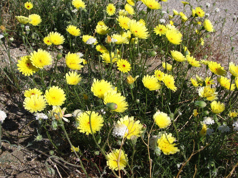
2/18/2010
Topic:
Anza Borrego Flower Season Update (02/13 - 02/14)
surfpontoAdministrator
|
Here is my update on the 2010 flower season out in Anza Borrego at the southern end of the park
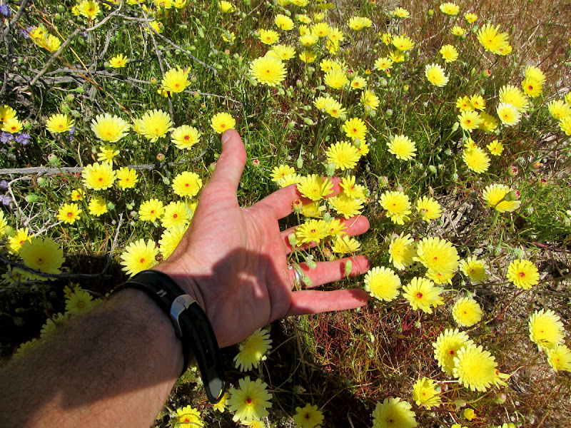
We saw many of the Ocotillo leafing up and looking very healthy. A fair number had orange buds.
Off of the S2 heading north near Arroyo Tapiado we saw a few large barrel cactus with yellow buds that looked close to flowering.
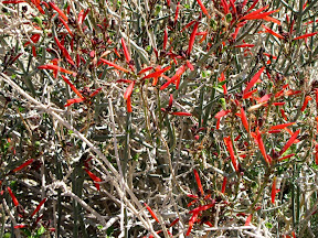
Near Carrizo Gorge / Egg Mountain / Bow Willow there were a few Chuparosa bushes that were flowering.
I am going to stick my neck out here and say that in 2-3 weeks (first couple weeks on March) it will be an amazing flower season out in the Anza Borrego Desert.

<em>edited by surfponto on 2/22/2010</em> |
2/22/2010
Topic:
All the Wild and Lonely Places
surfpontoAdministrator
|
Great book. I have a copy also.
Larry Hogue does still live in San Diego and runs a great website over at http://www.dpcinc.org/blog/
He is still very much involved in Desert conservation.
Great guy, I met him a few times at some of the anti-Sunrise Powerlink meetings and rallies.
I think I will reread my copy also.
Bob
hikerdmb wrote:
I am currently re-reading a great book on the Anza Borrego Desert. The book is titled “All the Wild and Lonely Places, Journeys in a Desert Landscape” and is written by Lawrence Hogue. I saw his name in the summit register on Whale Peak a couple years back so he may still live in the area. This book examines the Anza Borrego region of the desert, the people who lived there in the past, how the desert is today, and how it may be in the future. Each chapter of the book looks at a different area of our local desert (a couple chapters look at areas west of the desert). I have had the book since it was first published in 2000. It was given to me by one of my first grade students as a Christmas gift. I usually take it out every 2-3 years and re-read it. It is without a doubt one of the best student gifts I have ever received. If you travel in this desert, which I am sure you do or you wouldn’t be looking at this board, then I urge you find this book and give it a read. It will provide you with a whole new vision of the places you have been or will want to find after you have finished the book. Anyone else read this? Or know other books about the area that they recommend? |
2/26/2010
Topic:
Rain and wind this weekend
surfpontoAdministrator
|
We were thinking of heading out also but don't have an itinerary yet.
How much rain do you think we will get out there on Saturday?
News says 1/4" in the deserts.
Sunday is suppose to be nice.
With regards to your pictures, Internet Explorer opens them fine. Firefox I had to dowload them first and then open them.
Great shots of Blair Valley
Best,
Bob
<em>edited by surfponto on 2/26/2010</em> |
2/26/2010
Topic:
No Windmills in Ocotillo Bumper Stickers
surfpontoAdministrator
|
For those who are interested I have a limited number of bumper stickers I made regarding the proposed wind farm in Ocotillo.
Send me your address and I will send you one.
To read the post go here
Bob

edited by surfponto on 2/26/2010
<em>edited by surfponto on 2/26/2010</em> |
2/26/2010
Topic:
Rain and wind this weekend
surfpontoAdministrator
|
Yeah we have been out there on some pretty windy days.
No fun when you can't even get the propane stove lit to make coffee. 
My wife is pushing for us to just go out for the day on Sunday instead. so I will have to see.
Thanks for that link. May drive out to check that out also.
Good luck this weekend and report back
Bob
hikerdmb wrote:
I'm not so worried about the rain as I am about the wind. I see reports of 45 mph gusts on Saturday but letting up significantly on Sunday. I hope it rains another half inch or so. It will hopefully make everything last a little bit longer.
Did you see they are opening the new area of the park next weekend? Look about halfway down on this link...
http://www.parks.ca.gov/pages/638/files/Vallecito%20Days%20Information.pdf
We have been wanting to visit that valley for many years. The view west into that valley from the top of Whale Peak is what got us wanting to go there. Looks like hiking biking or horses is the only way in there for now. |
2/28/2010
Topic:
Flower Season 2010
surfpontoAdministrator
|
Update Sunday 2/28/10 :
We spent the day exploring southern Anza Borrego around Piedras Grandes and Mortero Wash.
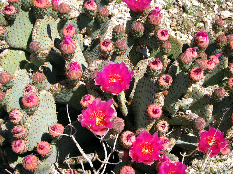
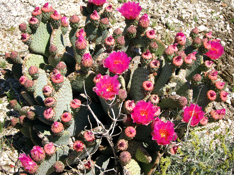
Saw an amazing Agave bloom in Mortero Wash.
Some Ocotillo blooms and a lot of red Chuparosa bushes but overall not much has changed from 2 weeks ago. There are buds on the cholla and barrel cactus that look like they are getting ready to explode.
I am going to say give it a couple more weeks if you are flower hunting.
<em>edited by surfponto on 2/28/2010</em> |
2/28/2010
Topic:
Palo Verde Wash and more
surfpontoAdministrator
|
Sounds like a great trip
Glad the rain dropped mellowed out a bit as you got down into the park.
Really sound like you know that end of the park. Will have to get some advice on cool camping places up there.
We did a day trip to Piedras Grandes / Dos Cabezas on Sunday (today)
Weather was perfect. Same story on flowers. Chuparosa, Ocotillo and a few Agave blooms but not much else.
Did it rain Saturday night while you were camping?
Bob
hikerdmb wrote:
We left home in a pouring rain on Saturday at about 11:00 AM. It rained all the way through the mountains and finally let up as we dropped down toward Scissors Crossing. Headed south on S-2 and did the loop around Blair Valley into Little Blair Valley. The pond from two months ago in Little Blair was gone. It rained off and on as we made the loop. Both valleys are very green! There are not many plants blooming, except ocotillo, but that will surely change in the next couple of weeks as there are lots of newly sprouted wild flowers.
After leaving the Blair Valley area we headed back north on S-2 and turned east on highway 78. Took a short side trip up Plum Canyon. Again it was quite green and the view down into Grapevine Canyon was beautiful with a mix of blue skies and huge puffy clouds over Pinyon Ridge. Saw a lot of Chuparosa blooming and a few very small flowers but there were plenty of new plants that will be blooming soon. The rain had pretty much stopped by now.
We retraced our route back down Plum Canyon and then headed farther east to Buttes Pass. Lots of ocotillo in bloom here and again many small plants not yet blooming. Perhaps a week or so more. Dropped down into San Felipe Wash and then took the Cut Across Trail to Fault Wash. Fault Wash was very sandy and not much growing in this area. At the top of Fault Wash we headed east on Short Wash and then south down Palo Verde Wash.
We went a couple of miles down Palo Verde Wash and then turned back north and headed for the upper part of the wash. We were looking for a sheltered place from the wind which was beginning to pick up as the sun was getting lower. Set up the tent and then it began to rain so we retreated into the tent. The wind blew pretty strong during the rain storm but we were dry and warm. It rained for about 3 hours. Then got out of the tent and made a late dinner.
The morning was clear and calm with new snow on Toro, and on the mountains up toward Coyote Canyon and Ranchita. I took an early hike up a couple of side washes near our campsite and found lots of Desert Lily plants, some blooming, some sprouted, and some with blooms which were not yet open. Not much else in this area blooming but like everywhere else there were lots of plants that had sprouted but not yet blooming.
After breaking camp we took Short Wash west to the Thimble Trail and then north to S-22. We drove into Borrego Springs for breakfast at the Red Ocotillo and then stopped by the Visitor’s Center. The lot was full so did not go in. I have never seen so many cars there before.
We then headed up the hill and back toward home at about noon. The view down into the valley was amazing. The Salton Sea was very clear and the valley around Borrego Springs is amazingly green.
Next week we will head for the southern part of the park. I am hoping with the lower elevations down that way there will be more flowers. The rain this weekend in the north should help the bloom last but it is at leastl a week or two away peaking. I attached a few pics below.
<em>edited by surfponto on 2/28/2010</em> |
3/1/2010
Topic:
Palo Verde Wash and more
surfpontoAdministrator
|
I like North Face tents. We bought an ASOLO 3 person for thise trips when we don't want to mount the roof top tent.
I think my wife was more concerned about the wind then the rain.
I just put up a post of our trip to Piedras Grandes.
Awesome spot.
Last time I was there was probably 15 years ago , when you could drive up the wash.
Bob
hikerdmb wrote:
It rained from about 5:30 to 8:30 Saturday night. The wind blew really hard during that time but I brought my North Face tent and it hold up to anything. |
3/2/2010
Topic:
Palo Verde Wash and more
surfpontoAdministrator
|
Nice. I like Indian Valley. We have camped there a bunch.
The road up into Piedras Grandes used to be open to vehicles.
We camped back in there a long time ago.
Not sure when it was closed but I think I read around 2000
Check this link
I may be out for the day Saturday or Sunday.
Bob
hikerdmb wrote:
Nice pics and trip report. What is the road that is not closed that you mentioned in the post? I was through there a couple of years ago and don’t remember anything different than the previous years. I don’t remember seeing that sign either of the pictographs either? Where exactly is that?
We still plan to go to the southern part of the park this weekend even though the forecast says more rain this weekend. We are hoping for some flowers to be blooming soon. I attached a picture from Indian Valley from spring 2009. Hopefully it will look better than this in a couple of weeks. |
3/3/2010
Topic:
The Mother of all websites on ABDSP Wild Flowers
surfpontoAdministrator
|
Welcome to the forum
Ocotillo are found in the Sonoran and Chihuahuan deserts of southeast California to west Texas and south into Mexico.
What I didn't know was that they are also known as
Candlewood
Slimwood
Coachwhip
Vine Cactus
Flamingsword
Jacob's Staff
On our last Baja trip I think I remember seeing Ocotillo on the Gulf side. They also had this crazy Ocotillo type plant that looked like something out of Dr. Seuss.
lindaally wrote:
Should be one of the best years for wildflowers with all the rain...I'm curious to know how many rare or endangered plants live in the Anza Borrego State Park....and does the Ocotillo grow elsewhere?? Thanks.
<em>edited by surfponto on 3/3/2010</em> |
3/3/2010
Topic:
The Mother of all websites on ABDSP Wild Flowers
surfpontoAdministrator
|
You are right David,
This guy has put in some serious time to put this together.
Awesome,
Bob
hikerdmb wrote:
My buddy sent me this link today. If you want to know about the wild flowers in ABDSP then check out this link. This guy has done a tremendous amount of work compiling the data you will see. It is amazing. Rainfall totals, photos, trip reports, and more!
http://tchester.org/bd/blooms/2010.html#rain |
3/3/2010
Topic:
The Mother of all websites on ABDSP Wild Flowers
surfpontoAdministrator
|
Funny you should mention that but I was able to download some photos and upload them to my iPhone.
I think DesertUSA made them available.
I think it covers all of the flowers and cactus blooms found in Anza Borrego.
hikerdmb wrote:
This part of the site
http://tchester.org/bd/species/gallery.html
has great pics of many flowers in the park. He says not all of them but there are plenty on there to try to identify. If I had an iPhone I would be trying to figure out a way to save that page to my phone (in case I was out of cell range) and then there would be no reason to break out the book every time I wanted to know a flower. I am sure someone will know how to do this. Or maybe there is already something like this available.
David |
3/6/2010
Topic:
South end of the park
surfpontoAdministrator
|
Hey David,
I will be out in that area Saturday. Some friends want to do an Indian Hill hike and then we are going to drive over to Canyon Sin Nombre.
Look for a couple of diesel Toyota LandCruisers |
3/7/2010
Topic:
Quartz mystery...
surfpontoAdministrator
|
Hi Cayenne,
Welcome to the forum. Sound like you had a great trip and will be back . There are so many beautiful places to explore out in Anza Borrego.
Curious where you saw those cool rocks?
From what I have read, quartz can be deposited between rocks and fissures by seeping water.
My educated guess is that it takes a very long time for this to occur.
Thanks for the heads up on the comments section. I need to fix that
Bob
quidditian wrote:
Hi David -- I've been trying to post the following in the comment section of the post you made today, but it's just hourglassing and hourglassing, and giving me no love...
Hi there -- I'm THRILLED to find your site, and look forward to exploring it. I just returned from my first trip to Anza, am and painfully in love with the place...and the fact that there seems to be no end to the wonderful things to see. I've always had an affinity for both the desert *and* native american cultures, but I'm heat-intolerant (whiny) and pretty much a hermit, so I never really go out to explore. This was an incredibly fulfilling whim; I felt as though my body was viscerally drinking in the perfect beauty and isolation of the landscape.
While there, I didn't have internet access, but built up a million questions, so now I'm a googling madwoman. One thing is sort of difficult to find anything on -- I went to see the morteros (and later pictographs) yesterday, and noticed something odd, but pretty obviously naturally occurring in the mortero area...perfect lines of quartz embedded along the tops of rocks and sometimes ground...almost like someone in the sky was drizzling icing on a cake.
Do you by any chance have any idea what causes this? I'm the world's worst photographer, but here are some pics...
http://www.flickr.com/photos/9702179@N08/4412269317/
http://www.flickr.com/photos/9702179@N08/4413037900/
http://www.flickr.com/photos/9702179@N08/4413037732/
Thanks!
Cayenne |
3/7/2010
Topic:
South end of the park
surfpontoAdministrator
|
hikerdmb wrote:
Sorry I didn't see this until we got back today. We were in that area Saturday afternoon. We were climbing on the train cars by the water tank about 1:30. There were a couple of rigs up on the little mound by the tracks just a bit up from tower but I didn't really see what kind of rigs they were. They were playing some music. Was that you? Sorry we missed you. I will post a trip report in a bit.
No we were probably over by Arroyo Seco del Diablo by then. We hiked around Indian Hill for a bit and then drove down Canyon Sin Nombre to loop back to the S2.
We were hoping that this one spot where we had previously seen a lot of wildflowers would be worth checking outs. Unfortunately all we saw was Sahara Mustard.
From what I have been reading the invasive Sahara Mustard is choking out the native wildflowers.
Here is a shot in 2005 somewhere around Arroyo Seco del Diablo
Bob

<em>edited by surfponto on 3/7/2010</em> |
3/7/2010
Topic:
Still Too Early
surfpontoAdministrator
|
Wow! It sounds like you guys had quite an adventure.
With regard to the Border Patrol apprehension, did you notice that there were not any water drop points anymore?
In November I remember seeing 5-8 water drop points around Carrizo Creek, Mortero Wash etc. But on the last few trips I haven't seen any?
I wonder if they are being removed.
Speaking of Border Patrol and Mexican migrants, you should ask me about my mid week encounter a few years back at the East Fork in Carrizo Gorge.
I agree on your flower assessment. One to two weeks it looks like there will be a lot more flowers. I noticed on the S2 towards Ocotillo there was a lot of color along the side of the road. Sand Verbena and Desert Dandelions were starting to come up so that is a good sign.
Did you get a chance to hike up the old jeep road at Piedras Grandes? It is really beautiful back there.
Sorry we missed you out there. We had a funny encounter with a group heading towards Indian Hill along the tracks. The lady in the front had an AWD Saturn Vue and was convinced she could make it up this one off camber hill.
She never did quite make it up, not sure I would have tried either in that vehicle, and ended up driving back around the easier trail north.
Saw some illegal trail damage near Indian Hill from an ATV. That really bummed us out.
Take Care,
Bob
hikerdmb wrote:
Just returned from a weekend trip into ABDSP and again this weekend there was lots of wind and more rain than last weekend. It is still too early for lots of flowers but it is very green and it rained on us from about 4:00 AM Sunday until we left the desert at about noon. It was a continuous rain, never turned off the windshield wipers all morning.
We went out highway 8 to Ocotillo to begin our trip. We took the old highway 80 west from Ocotillo and worked our way up the wash and into the very southern part of the park in the Dos Cabezas area. Stopped for lunch at one of our old campsites and then continued on north. Found that the road to Piedras Grande is closed and I was surprised to read from the sign that you can no longer camp in that valley, only day use. We then continued up to the water tank and took some pics. Then down Mortero Wash to S-2.
Headed north on S-2 and went up into Indian Valley. Went about 2/3 of the way up each side of the valley. Visited a old smoke tree that we camped by many many times when my daugters were young, I guessed 20 times but my wife thought it was more than that. The tree is now dead and on the ground for the past 5 years or so. It was a little sad. As we left Indian Valley and were almost back to the highway I saw 2 men standing at the junction of the dirt road and highway. Then a Border Patrol truck pulled up, nabbed one guy and the other fled into the desert. He did not appear to have any water or supplies. The BP chased after him and if he wasn't caught he had a miserable night of wind and rain.
We headed into the east side of Carrizo Creek and camped in the area wher Arroyo Seco Del Diablo meets Carrizo Creek. It was quite windy and started to rain just at sunset. We camped on a little side wash where have camped a few times before that is protected a little from the west winds. The rain wasn't much and it stopped shortly after it began. We had a nice fire and the wind died down before we went to bed. We saw some lightning to the east with huge thunder heads.
I was awaken by the sound of rain on the tent at 4:00 AM and it never stopped. Breaking camp in the rain is no fun! We were planning on going back to Indian Hill and taking a hike but with the rain we changed plans. I see now that I am home that rained 0.66 inches in the Fish Creek Mountains. Nice!
Instead we headed north and just toured through the park. I couldn't believe the number of RV's and toy haulers heading west on 78. I think we were still too early for flowers but the week ahead should be sunny and warm so maybe next weekend the real show will start.
We did find a few flowers this weekend and I attached a few pics.
|
3/7/2010
Topic:
Quartz mystery...
surfpontoAdministrator
|
Hey Cayenne,
You write very well. I am sure any trip report you wrote would be interesting to read.
Sounds like you are hooked and I for-see many ADSP camping trips in your future.
With regards to the pictographs near Blair Valley. I agree that is amazing they are just accessible to everybody who can hike the short distance.
The pictographs at Piedras Grandes have not fared so well and were apparently destroyed (almost) by a careless campfire.
I believe that is one of the reasons they closed that area off to vehicle traffic.
No you are not a techno-moron with regards to the comments section. I need to update the BLOG software but I am a little worried I will mess something else up.
Also I notice there is an issue with picture uploads on the forum.
Need to fix that also.
Thanks for the post
Bob
quidditian wrote:
Thanks for creating the forum -- I'll probably be plaguing you (et al) with more random questions as they come to mind, but it's great to know there's a wealth of knowledge here!
Eventually I'm going to write a trip update. Not only would I like to write it out for the sake of sending it to friends so they can ridicule me, but I think it may amuse/appall people who frequent this forum. If nothing else, my tale is a lesson in not thinking oneself impervious to "bad things" happening. Hint: Out-of-shape, technophobic 40 year old recluse in an old sedan heads out alone for desert adventure. I was like "Private Benjamin" of the desert.
So the rocks were in Blair Valley -- where the state park has the historic sign for the morteros -- then one walks a very short distance to the big beautiful boulders that have morteros tucked away in them. The quartz phenomenon was pretty pervasive in that area. I think most surprising was the first pic where it shows the "line" on the ground. Weird enough to see it on the rocks themselves, but very strange along the ground. Of course, I'd love to have sort of picked around it to see how far down in the sand it went (I'm amazed it hasn't been disturbed by foot traffic -- maybe it's just on the top of a big rock buried underground, thus keeping it somewhat stable? Hmmmm...) As a former wanna-be archaeologist, I know to keep my hands to myself, so I didn't investigate.
When I moved on to the pictograph area further down, I don't think I saw the quartz lines on any of the rocks around there...and it's what, maybe a mile(ish) away?
Speaking of things being disturbed...I was amazed the pictographs are sitting there unprotected. I mean, that's certainly the most moving way to view them, but I lived in Wyoming for a year after college, and they have the petroglyph sites at Castle Gardens completely cordoned off behind fencing (one could see evidence of spray paint in places on the glyphs, which tended to leave one with no faith in humanity). I suppose it's a testament to human nobility that the pictographs can exist without damage in their natural state...it's also makes one worry a little. It only takes one a**hole to come along ant destroy...
Okay, enough babbling for now. The comment "issue" on your blog could have been total user error...as noted, I'm a technomoron. :]
Cayenne
<em>edited by surfponto on 3/7/2010</em> |
3/8/2010
Topic:
South end of the park
surfpontoAdministrator
|
Thanks Cayenne,
I was out to the same area on Saturday of this week and unfortunately all we saw was Sahara Mustard
I am hoping that is not a sign of things to come in this area.
regards,
Bob
quidditian wrote:
Fantastic! I love the perspective making the pooch larger than the people. Adorable. Wonderful gradation of color on the mountains and sky, and also nice to see the flowers that I otherwise missed... |
3/8/2010
Topic:
First fumbling pass at experiencing Anza Borrego
surfpontoAdministrator
|
That is a great story. Sorry about the toe. It looks very painful from the pictures.
Your pictures are very good by the way.
I am surprised the ranger sent you up there with no warning. When it comes to soft sand and a two-wheel drive car speed is your friend.
Well I guess unless you run into a rock or something.
Thanks for sharing your trip report. I am guessing you will get some comments. Fingers crossed.
regards,
Bob
quidditian wrote:
By way of update, I've put together this pictorial web album to send to friends. It's 92 pics, so don't feel like you have to plow through all of it -- though it should be noted I pared down the pics from the 250 I came home with :}...
http://picasaweb.google.com/Quidditian/AnzaBorrego33103610#
What should be known about me is that I adore being at home, puttering around my house (apartment) and patio/studio. I don't often, as I say, "Go Places and Do Things." I loathe driving, and am terrified of anything other than the trek up and down the 805 to Del Mar that I made for nine years (before being laid off in August). I DO love nature, but getting me out of the house requires an act of god. The fact that I'm completely content at home, and am further high-maintenance (in that girly-buff-and-fluff sort of way) and hate driving effectively squashes any sort of adventurous spirit.
I'm trying to force myself to do all of the things I've always wanted to do now that I have the time, and some quality time in the desert was/is top priority on that list. I would live in a desert, were it not for the heat -- everything else we typically associate with the desert speaks to me on a very primordial level.
The problem with desert adventuring, I've learned from this trip to Anza, is that I love to be alone...act on my own whims, and not be disturbed by human voices; I also like to linger over simple things that bore other people. I think the compromise with myself going forward will be that if I'm to go alone, I need to stick to fairly populated areas.
Sooooooooo, what's not mentioned in my little pictorial foray is what happened on Thursday, as I attempted to get to Font's Point.
I'd gone to the Visitor's Center first, and talked to a ranger to try to map out my path. A friend had recommended Font's Point, and when I told this to the ranger, he asked what kind of car I drove, then said I "should" be okay.
Well, not so much. I drive a '99 Mazda 626. As evidence of my lack of travel, it only has 96k miles on it, and I fully intend to drive it into the ground. I'm like the proverbial old lady who only drove her car to church downhill both ways, save the fact I don't "do" church.
I was nervous as I got a bit into the dirt road leading to Font's Point...very soft and shifty sand, but it was do-able at snail's pace. I was, I imagine, 3/4 of a mile in when I saw a stalled little car...maybe a Focus or something similar. I checked to see whether anyone was in it, thinking someone might be in trouble, but it was empty. I only made it a few yards further when I became completely, utterly, and hopelessly stuck in the sand.
Well then. "Now what?" I thought as I surveyed the desolate landscape. For about 15-20 minutes, I alternated between trying to go forward and reverse, giving little rests each of the 2-3 times the engine stalled out. There was a slow and creeping panic that I wasn't allowing myself to succumb to. Here I will note that part of my reclusiveness combined with technophobia is that I don't own a "real" cell phone. I have an ancient thing that can be used to dial 911 if required -- this was a hand-me-down phone given to me years ago by a friend who was annoyed that I didn't have some sort of connection to the outside world in case of an emergency when in my car.
After literally spinning my wheels, I finally opened my door to assess the situation, and found the sand was up to the entry level of the car (I've since measured this as nine inches). I closed the door and focused on not panicking. As I looked up, I saw a coyote scurry across the "road." Somewhere in my ever- darkly amused brain, I thought "just toss in some vultures circling overhead, and we've got ourselves a cartoon." Visually, the scene was strikingly beautiful, with a bit of an almost unreal/surreal gorgeousness to it that, I believe, kept the panic at bay.
By some miracle, my next attempt to reverse gave me enough traction to fly out of my pit, squiggling and wiggling all over the place as I flew toward solid(ish) ground. I imagine the reality of the situation would have eventually been most unamusing had it gone on much longer. In the entire time there, I never once saw another car pass. That night, safely back at the hotel, I discovered that I had left my 911 phone in my purse at the hotel room, and not packed it in my hiking bag that morning -- had I discovered that while I was stuck, I surely would have completely freaked out, as calling 911 was the only back-up plan I had in mind (would I even get a signal there? Something else to consider...).
At about the same place I flew out of the sand, there were other shallow winding tracks where it appeared someone had encountered the same thing I did, and also managed to get out (unlike the unfortunate Focus owner). I've since looked at a couple of you tube videos of that road, and they were relatively navigable -- NOTHING like what I encountered.
I didn't put it together until yesterday, but this Tierra Del Sol 4x4 thing was the 5th - 7th, and I wonder if some attendees had come out a day early and ripped up the road with their ATVs or whatever other sorts of vehicles they use.
That was my potential disaster for Thursday. In retrospect, I should have reported the whole thing to the rangers, if for no other reason than to prevent the same thing from happening to someone else, and also in order to do some sort of a safety check on the Focus owner. Now I feel like a cad. I guess I just thought it was "normal" until I saw the you tube videos once I was back home yesterday. I had silently cursed the ranger for not giving more warning, but perhaps that's because the road condition was truly anomalous, and he simply didn't know. Maybe I should still make a call so they can be vigilant in the future...or maybe it's all too much to keep up with even when the 4x4 peeps aren't descending on the place...or maybe I just shouldn't be stupid enough to go tooling around in the desert alone with no cell phone. Sigh.
Next lesson learned: Broken Toe Friday. This one is less wordy, I promise. :] This incident is purely devoid of external influences, and entirely my fault.
Now, by today I had my 911 phone, but the point was moot, since there was no signal in the area. I'd spent a good amount of time bouncing around the mortero area, so as I made the hike to the pictographs, my out-of shape legs were already feeling a little noodly...the uphill grade is very slight for a normal person, but I was definitely feeling it.
In short, I climbed up over a couple of boulders, and on the other side my feet met a relatively flat slab of granite with a fine layer of sand on it. No, I was not wearing hike-appropriate shoes, and subsequently found myself with head resting in a little cholla branch, breathlessly (literally) gazing up at the lovely blue sky.
As I lay there, shadows increasing in the 4:00 pm sun, with leg twisted up under me, I was cognizant that this was not good. My toes were in screaming pain for a brief period, and my only thought was "oh PLEASE let me be able to walk." Thankfully, I was...albeit trudgingly. I knew I had to be close to the pictographs, and as long as I could move, I intended to drag the rest of the way up there.
On the way back down, I sort of wanted to put a little cairn at the falling spot, but I A) felt too much like an outsider to the hiking world to be erecting cairns and, B) was desperate to get out of there before dark (you guessed it -- I didn't have my flashlight with me...it was luxuriating on a bed back at the hotel).
Later that night I thought "what if I hadn't been able to walk?" Again, I'm glad the full repercussions of that didn't occur to me while I was on the ground, else the increasingly-familiar sense of panic would have set in. I mean, that's not territory where your friendly EMT puts you on a stretcher and rolls you out... No, even when someone finally finds you there (hopefully by the next day), there's got to be an airlift involved. I'm wondering whether Kaiser covers that. I mean, co-pay on an ambulance is $50 -- what's the co-pay on a helicopter? :]
The fact that I was there during the week vs. weekend was a double-edged sword. I loved the lack of people, but if I'd truly gotten into a bind I sure as heck would have been hoping someone wandered by...
All of this aside, it was the most precious four days in recent memory. I'm a hard-core rationalist, but I still like to think "the gods" let me out of there basically unscathed because my foibles were a good source of entertainment. They prolly get bored looking at all of you people who know what you're doing. ;]
edited by quidditian on 3/8/2010
edited by quidditian on 3/8/2010 |
3/8/2010
Topic:
Quartz mystery...
surfpontoAdministrator
|
OK David,
You win. My theory about water was just that.. a theory.
Seems you were actually paying attention in your college Geo class unlike me.
Bob
quidditian wrote:
Okay, finally posted the pics of quartz lines for my best friend (and living encyclopedia), and gave him David's theory. He wrote:
Well, that seems plausible. When I saw them, it made be think of "friendship rocks" that have a line running through them, found in Maine. I've no clue how they are formed, so will have consult my trusty, dusty wikipedia.
In the next email, he said:
That was a bust, I'm going with that guy's theory.
Then he sent this link. It seems that your memory from "many moons ago" is perfectly in tact, David. :]
http://en.wikipedia.org/wiki/Dike_%28geology%29
Thanks much!
<em>edited by surfponto on 3/8/2010</em> |
3/8/2010
Topic:
Quartz mystery...
surfpontoAdministrator
|
What is even more perplexing is the "Blue Sun" pictograph at Indian Hill.
We can't figure out how the Kumeyaay artists were able to come up with the color blue from what was available?.

quidditian wrote:
Thank you -- you're kind. You may eat your words when you see the novella I just wrote as an update. :] PLEASE don't feel like you have to read it. It's sort of self-serving as a way to document my little experience...
That's a flippin' gorgeous pic...could be an abstract painting, nicely picking up the texture and dimension.
It's perplexing... I went around and around last night about the issue of preservation of these things. My experience at Castle Gardens was...um...sixteen years ago, and the status may be better or worse at this point. It made my heart ache to see this ugly man-made structure around the carvings, but I also fully understood the need for it to be there. My misanthropic tendencies are only fueled when I realize how utterly clueless, if not downright malicious people can be... and the pictographs are even more fragile than petroglyphys, I would assume.
Which brings to mind another point to google: I wonder what sort of pigments they used for the pictographs. Even if only 200 years old, the elements are extreme, and there's no modern paint equivalent I know of that would hold up to the the elements -- especially given the ultimate fragility of the "rock canvas". I'm fascinated by contemporary painters who make their own pigments (I think there are maybe two such people currently alive), but I haven't much looked into the logistics of it...seems like an overwhelming endeavor.
Camping -- don't count on it -- I wish it were easy for me. Alas, having found the creepy little affordable hotel I love, I hope to return often enough that they'll eventually name one of the rooms "The Cayenne Suite." After I die/retire, I hope to haunt the place unimpeded by physicality. Maybe establish a little B&B on Ghost Mountain. :o <---scary ghost
edited by quidditian on 3/8/2010 |
3/8/2010
Topic:
Still Too Early
surfpontoAdministrator
|
Hi David,
No I haven't seen that. If you are standing at the mouth of the cave is it to the South on that far ridge or is it to the West?
I would like to check that out sometime.
There is something similar by the Mortero Palms.
I think I am going to do a solo overnight trip during the week next week.
I want to hike up Rockhouse Canyon (BLM) past the linehouse that is up there.
Regards,
Bob
hikerdmb wrote:
Bob,
Yes I did notice there was no water drops anymore. I wonder who took them.
I was really hoping to get back to the cave at Indian Hill and check out the tank across from it. But it was raining so hard on Sunday morning there is no way I was going to do it then. Perhaps another day. We still want to do a couple of backpacking trips this year before it gets too hot and with my daughters coming home for a week and then a planned trip to Yosemite for backcountry skiing I don't know if I can fit it all in. But I am sure going to give it a try.
Did you make it that far with your friends? Did you see the tank? Have you seen it before? The first time I saw it it was almost full but each time after it has been empty or nearly empty. It is about the size of a bathtub. I have a picture of it somewhere but can't seem to find it. When standing in the mouth of the cave it is across a little wash up on the side of the hill about the same elevation as the cave.
David
<em>edited by surfponto on 3/8/2010</em> |
3/9/2010
Topic:
First fumbling pass at experiencing Anza Borrego
surfpontoAdministrator
|
For a real Desert experience try heading out there in the summer.
Last summer I went out for the day and I think they said it was pushing 110' F
Couldn't convince my wife to come out on that trip.
I saw one person the whole time. Of course I didn't stray more that one mile from my Landcruiser.
Not sure I would do that again.
It felt like I was only person on the planet.....
quidditian wrote:
Thanks, guys --
Well, it may be time for me to join this century and at least get some sort of real cell phone that I could use to text people before I leave for an excursion and check in upon return. I see the temps are already climbing into the upper 70s this weekend, which means by the time I can walk 100% again, it'll be too hot for me (told you I'm whiny). Luckily, the toe isn't excruciating...I should be good to go within 2-3 weeks, I hope.
I'll have to spend some time sniffing out other places in the park with non-camping lodging and potentially cooler temps (if either of these things exist as we head into April/May).
Just read reviews on Between A Rock and a Hard Place. Ugh. Double Ugh.
*slaps self for stupidity* |
3/9/2010
Topic:
Quartz mystery...
surfpontoAdministrator
|
Great links Cayenne,
Thanks. His website is very interesting.
Thanks for answering that.
Bob
quidditian wrote:
Hmmmmm...found this in this link: http://www.kumeyaay.info/indian_bows_arrows.html
"This fully-researched book will include all facets of Native California pigments and paint, including physical, social, spiritual — in great detail — and will reveal about how the Indians turned yellow pigment red, and how the aborigines made blue from white gypsum and black charcoal, and it will give many other recipes for Indian paint.
The book will also discuss the origin of CAVE ART in California and will include the latest atomic accelerator testing of the ancient pigments used by California Indians for eons."
Also while tooling around looking for pigment-making info, ran across this guy, who has some fascinating theories that the pictographs (at least some of them) may not have had their origins as art, but as maps to shelter and water. He has to make some pretty large leaps of faith and imagination, but it's an interesting theory, and he doesn't seem to be a whack-job. :]
http://www.humancafe.com/discus/messages/6/41.html#POST3981
And he and his friend think that the light scalloping on this rock (what I thought were shallow morteros) were a calendar. I wish I'd known all of this before I went out there!
http://picasaweb.google.com/Quidditian/AnzaBorrego33103610#5446087321899249570
Groovy stuff. |
3/10/2010
Topic:
Still Too Early
surfpontoAdministrator
|
I agree, that picture is amazing!
You must have been really close.
I want to find that water tank. That looks awesome.
Bob
quidditian wrote:
Holy crap, those are magnificent. The rock tank is unbelievable! I guess even if there's no movement with the water, it's drinkable (should it come to it) and swimable/bathable since it's replenished in the sense that it evaporates and is eventually refreshed.
This Ivan Alexander, whose links I posted elsewhere regarding the pictographs being maps to shelter and water (rather than somewhat random shamanistic/artistic scribblings) has captured my imagination about certain pragmatic things in the desert. I mean, they DID require drinking water (I forget this with my handy dandy bottled water), and they DID bathe when and where possible.
I feel like I'm falling in love with the mysteries of native culture all over again...it sort of got shoved aside years ago when eeking out a life got in the way of being enraptured by the past. Dormant cells jiggling and wiggling into wondrous curiosity again. Man, the power of the desert.
I love the migrant guy. That's totally Nat Geo worthy. |
3/12/2010
Topic:
Anza Borrego Foundation "Hike of the Month"
surfpontoAdministrator
|
Mary and I signed up to do the Anza Borrego Foundations "Hike of the Month" to Harper Flat. Usually we shy away from organized tours of any kind but this one is being led by Mark Jorgensen who was the superintendent of the ABDSP for many years.
I think it will be interesting to hike with someone who know the park so well.
If you are interested the link is here but you need to preregister.
Hike Of The Month Harper Cabin
I will post back on Sunday.
<em>edited by surfponto on 3/12/2010</em> |
3/12/2010
Topic:
Anza Borrego Foundation "Hike of the Month"
surfpontoAdministrator
|
Thanks David,
Appreciate the advice. I will GPS the cabin. I am excited to go since like I said earlier I usually don't stray north of Indian Valley. Time to expand my horizons.
Will do a quick writeup when return with pics
When is your next trip out?
Still thinking of a midweek overnight trip next week also.
hikerdmb wrote:
Bob,
Harper Flat is a great valley. I have backpacked in there once every year or two for the last 10+ years. You will like it I am sure. I am interested to see how the flowers are in there this year since I have not been in there since last spring. In fact the weekend we camped in there last year we ran into a group of 12 or so people. That was only the second time we saw anyone else in the valley. The other time we saw one lone day hiker. I wonder if your group is the same group as last year. There is lots of evidence of past habitation in the valley. We have found morteros on the south and north edge of the valley. I have read of sleeping cirlces somewhere in the Flat or Harper Canyon. We have searched more than once for them with no luck, have not looked on the western side of the valley. Maybe you will get led to them by Mark.
Also on your way out you might want to look in some of the side washes that join Pinyon Wash from the east. Last spring there were LOTS of flowers in those washes. The most I found were in a wash that joined Pinyon Wash at a slight angle from the southeast. It was somewhere south of where Nolina Wash joins Pinyon Wash.
Also I just read the link you provided and it said something about a cabin. I would like to know where that is if you will share upon your return. Have not seen that one before. In fact I didn't even know about it.
I hope you have a great hike and find the sleeping circles. Looks like more wind on Saturday.
David
I fixed a couple of directions when I got home and looked at a map.
edited by hikerdmb on 3/12/2010 |
3/12/2010
Topic:
Still Too Early
surfpontoAdministrator
|
Not sure I should post this but once when i was solo in the East Fork of Carrizo Gorge I surprised a group of 10-12 migrants.
They scattered when they heard my diesel coming up the canyon but I said in my bad Spanish. "Its' OK", or something like that. Suddenly they all stopped and started walking towards my LandCruiser.
First thought was OK I am by myself and there are 10-12 dudes walking towards me. When they got closer I realized how bad they looked, this was late April and It was over 90', so I gave them what was left of my food and water.
hikerdmb wrote:
I wasn't really that close, maybe 10 -15 yards. I did use a little HP Image Zone program to zoom in a bit before I posted it. It was strange seeing one guy just give up and the other take off running. Then the Border Patrol guy got back in his truck turned on his lights and took off after the runner.
<em>edited by surfponto on 3/12/2010</em> |
3/13/2010
Topic:
Anza Borrego Foundation "Hike of the Month"
surfpontoAdministrator
|
Hmm that is weird. I have been working on updating the site.
May have to update the forum software
I will play around with it some more tonite
Can you try it again?
Hike was great. Will post some pics. Harper Cabin is really cool as is the dam they built out there.
Bob
hikerdmb wrote:
Bob,
Having trouble posting anything other than a line or two of text.
edited by hikerdmb on 3/13/2010
edited by surfponto on 3/13/2010
<em>edited by surfponto on 3/13/2010</em> |
3/14/2010
Topic:
Still Too Early
surfpontoAdministrator
|
Hi Cayenne,
It was a weird experience. They looked like they had been out there for a while and really needed some help.
I think we were both surprised to see each other.
Can't imagine what it must be like for them trying to make it across Anza Borrego like that?
I wouldn't say they felt threatening, Probably just my paranoia at first.
Bob
quidditian wrote:
Well, after David posted the pic, it added to the list of potential dangers. Although, I doubt murder is at the top of their priority list when they're just trying to get across the border. I've always been a registered Libertarian, but also the daughter of a German immigrant (albeit legal), but I've never been able to land firmly on one side or the other of the immigration debate. I see both sides.
I think what you did was precious. The fact that they started to approach you, though...even though you said "it's okay"... did that feel at all threatening, or did it seem more that they might politely ask for some provisions? I've heard of groups who go out and provide food and water for these guys, so maybe they thought you were one of those peeps. Seems like a few years ago the migrants were dropping like flies in the summer, and that's when people started organizing and, much to the chagrin of the BP, giving out food and water.
What you did supersedes politics...it's just the human and humane thing to do.
Still, would have scared the crap out of me. |
3/14/2010
Topic:
Anza Borrego Foundation "Hike of the Month"
surfpontoAdministrator
|
I have head this story.
I think Desert USA has a link to it on their website. Pretty cool.
I always thought it would be cool to camp up at Ghost Mountain during a full moon. Place has a definite spiritual feel to it.
I am working on putting my post and pictures together from Saturday's trip to Harper Cabin.
In the meantime if you want to see the caption-less pics check :
Slide Show
Like you said David, Harper Flat is amazing. Really feels like you are getting away from civilization when you hike out there.
Bob
quidditian wrote:
Have you guys ever seen these lights? I love mysteries...especially creepy-spookyish ones. I don't indulge in them very often. It's like a metaphysical brownie with double frosting. Uh, or something.
Speaking of unexplained stuff, when I was on the pictograph trail....there was a noise that was like a very distant thunder, but with minor key edges. Maybe 4 - 5 seconds each in length of sound... If I had any reason to believe there was a drum circle in the area, I'd have thought it was someone with a very very bass drum and very strange choices on when to strike it (it was arrhythmic). I heard it three times within about two minutes. Might it have been the sound of a boulder tumbling down in the distance, or did I hit my head too hard on the little cholla? It was a powerful sound, and if I believed in invisible things, I would have assumed a god somewhere was speaking. It was a beautiful, stately, and powerful rumble, but I'm not sure whether I would have thought the god was angry or pleased.
I honestly would have thought it was distant thunder -- it sounded exactly like it, but there were no storms brewing.
If a boulder tumbles and there's an idiot out alone in the desert to hear it, but said idiot is not only idiotic, but also a recent concussion recipient, did the thunderous noise happen at all?
<em>edited by surfponto on 3/14/2010</em> |
3/15/2010
Topic:
Anza Borrego Foundation "Hike of the Month"
surfpontoAdministrator
|
Hey David,
I will pull off the Waypoints on my GPS to show you where we were.
I just posted the trip report with most of the picture captions.
The kitchen is pretty intact as is the bed.
I guess the support structure was built with Agave stalks so those are long gone.
Both dams were totally filled with sand.
If you have made it to the dams you were really close to the cabin. I believe it was one canyon over.
Bob
hikerdmb wrote:
Bob,
Nice pics and looks like it was a great day. Can't wait to see the trip report and maybe a map to show which parts of the valley you visited. The cabin looked pretty broke down. Was the damn totally filled in with sand?
David |
3/15/2010
Topic:
Anza Borrego Foundation "Hike of the Month"
surfpontoAdministrator
|
Hii Cayenne,
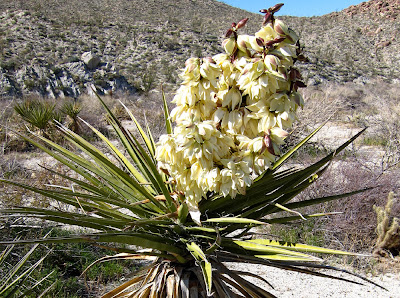
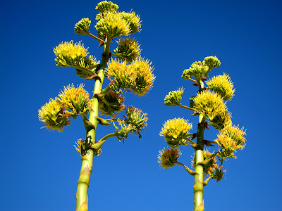
I think blooming Agave and Mojave Yucca are fast becoming my favorite plants out there.
The colors of the Yucca are amazing.
From what we were told the Indians used to cultivate the Agave when it would first start to bloom.
Apparently it is full of nutrients since it contains all the plants energy as it begins to shoot the stalk skyward.
Mark Jorgensen (The ex-Park Superintendent) who was leading the tour said they have recorded Agave stalks that have grown 14" in one day !
The hike is a little ways out there so that probably will keep it intact for a long time.
Bob
quidditian wrote:
Man, that final cactus is divine. As far as these ruins go, I'm so heartened that people don't mess with them. I guess the the upside of having to make an actual trek to get somewhere is that you're not the sort of person who makes a trek in order to destroy things.
edited by surfponto on 3/15/2010
edited by surfponto on 3/15/2010
<em>edited by surfponto on 3/15/2010</em> |
3/15/2010
Topic:
Trip to Harper Canyon
surfpontoAdministrator
|
Our trip to Harper Canyon in the central part of the park was a great success. Great weather with a little bit of wind.
A lot of blooming Agave in the area and a few Mojave Yucca.
Still think we are in for a great flower season in two - three weeks time,
Trip Post
Bob |
3/15/2010
Topic:
Trip to Harper Canyon
surfpontoAdministrator
|
Hi David,
Yeah he is basically a walking Encyclopaedia of the Anza Borrego desert.
He remembers giving me a warning ticket a few years back in Carrizo Gorge for parking off the trail.
Great guy. I would definitely take another trip with him if one comes up. Apparently the ABF is trying to get him to do a trip every week.
To answer your questions.
Yes the Indian site is where you said. right to the left as you come into Harper flat.
The dam and the cabin are in two separate side canyons.
when you say you drove does that mean you came down Heart Attack Hill and the Squeeze from that side?
I should have asked him about the sleeping circles...shoot :-(
He did tell me where to find the Carrizo Gorge Pictographs.
I think they are the one's that according to him may have been "touched up" in the 1940s.
Bob
hikerdmb wrote:
Bob,
Nice trip report. It must have been pretty cool being guided around by Mark Jorgenson. How far down Harper Canyon did you go before you came to the dam and the cabin? At the end of the post you said you hiked down Harper Canyon. Did you go all the way down and out or did you go back through Harper Flat and out Pinyon Wash? I have never been down into Harper Canyon. We have walked by the entrance to the canyon while in Harper Flat a couple of times but never entered it. And we have driven to the lower entrance a couple of times too. We have even discussed hiking up Harper Canyon as a way to get to Harper Flat but it so much longer and with way more elevation gain than going through Pinyon Wash, so we have always taken the easy way. Also, any word on sleeping circles? And did you check out any of the side washes in the lower part of Pinyon Wash. I am curios too if the Indian site was just to the left as you entered Harper Flat or somewhere else. I know there are lots of morteros about a half mile or to the east after you get into Harper Flat.
David |
3/15/2010
Topic:
Trip to Harper Canyon
surfpontoAdministrator
|
Oh I see. I forgot about the Fish Creek access.
No we basically turned around and came back the way we came. (Pinyon Wash)
Harper canyon is cool. It is pretty narrow with vertical side walls.
I can send you a Google Earth link tonite
Here is a pic I found of the pictographs in Carrizo Gorge.

Like I said, I think they were touched up years ago. I think they are hard to find but I have a general idea of where thay are.
Bob
hikerdmb wrote:
Bob,
I have never been down that drop off by the squeeze. I have been to the top and I have been close to the bottom by coming in through Split Mountain/ Fish Creek, but never been all the way through. When I say we drove to the lower part of Harper Canyon...you can take a dirt road off of highway 78 that will take you to the lower (northern) mouth of Harper Canyon. Sorry I wasn't too clear on that. You can hike up (south) into Harper Flat from the end of this road but it is much longer and more elevation gain than by going through Pinyon Wash. Can you send me a google earth of the location of the cabin and dams?
I did not know about pictographs in Carrizo but I would like to. I know that in Joshua Tree there are some pictographs that were retouched for a Disney film but this is the first I have heard of this in Carrizo. I have seen the pictographs in JT and they are very fake looking.
Also I am still confused on your exit from Harper Flat. Did you go back the same way you came in? If you did go all the way through Harper Canyon I would be interested in knowing what it is like through there.
David |
3/16/2010
Topic:
Trip to Harper Canyon
surfpontoAdministrator
|
Hey David,
I emailed a Google Earth Waypoint of the cabin.
Let me know if you have any trouble with it.
I forgot to ask, have you seen the dam out there?
If you have you were very close to the cabin
Bob |
3/16/2010
Topic:
My homage in paint...
surfpontoAdministrator
|
Hey Cayenne,
I see you more as a Toyota Land Cruiser or 4runner person than an Escalade Person
My Camry owner neighbors that we drove out to Pinyon Wash last weekend are now convinced they need a 4WD vehicle.
having 4WD does give you a certain level of confidence.
I am coming to the fast realization that David is very knowledgeable of Anza Borrego Desert.
I am glad he is on the forum.
I also like your creative descriptions and sense of humor so I am glad you have spent time on the forum also.
I have to fix that image upload thing. It seems to mess up the files if they are too large.
Bye for now,
Bob
<em>edited by surfponto on 3/16/2010</em> |
3/17/2010
Topic:
Anza Borrego Foundation "Hike of the Month"
surfpontoAdministrator
|
Hmm, he did mention that
Maybe I should add that to the post
Thanks,
Bob
quidditian wrote:
Looks like it may have quelled the native sweet tooth as well :}
|
3/17/2010
Topic:
My homage in paint...
surfpontoAdministrator
|
Time lapse of an Agave ! That would be totally cool.
quidditian wrote:
Wellllll...I once remarked to a former boss that I need a personal driver, and she pinged back that I'm really more of a private jet kind of girl. Not so much for the snootyness factor, but for the deep and abiding hatred of driving (sure, like I'd be any less neurotic flying?)
It's great to have you guys as a resource, and even if I never get to go back to AB for any length of time, I love living vicariously through your reports and pictures.
For sake of clarity, I was reminded that sis's big-honkin'-truck is the Honda version that looks like the trucky-Escalade. Shows how much attention I pay to things with wheels. :]
Now, to find a nice time-lapse version of an agave stalk growing... |
3/18/2010
Topic:
Indian Hill
surfpontoAdministrator
|
Sounds like a great trip.
That is one of my favorite areas. I wonder if it will be busy with all the wildflower hunters
Bob
hikerdmb wrote:
This weekend looks like it will be clear and sunny with a very tame wind. I will be heading down to the south end of the park again and hiking into the Indian Hill area and checking out the tank, the cave, and the rest of the area. It has been a few years since I have hiked into this area and I am very excited about the weather and returning to this part of the desert. Maybe we will even find a field of wildflowers but I will definitely listen to Tom Petty's old (1994) album "Wildflowers" while I am on this trip. I will be sure to post some pics and a report.
David |
3/18/2010
Topic:
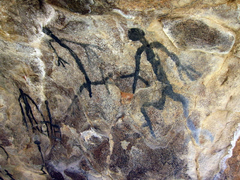
The Hunt for the elusive Carrizo Gorge Pictographs
surfpontoAdministrator
|
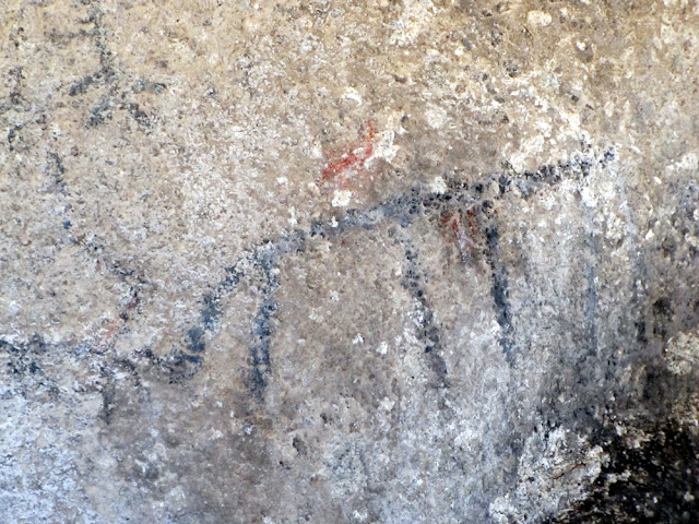
Took a solo trip out to hunt for the Carrizo Gorge Pictographs and wildflowers.
I was succesful on both counts. On my hike up to the cattleman's house in Rock House Canyon (BLM) I was surrounded by Desert Dandelions, Chuparosa, Desert Chicory, Sand Verbena and many others. The smell was amazing!
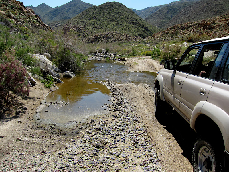
Drove back down to Carrizo Gorge jeep trail and headed west. Road has gotten really bad in places. You definetly need a 4wd with a low range to get past many areas. There was tons of water in Carrizo Creek which I haven't seen before.
Finally after much bouncing around I parked my Landcruiser and began to explore the area. I had sketchy directions for the pictographs but within 15 minutes I was able to find them.
They are really cool. I would love to hear if anyone knows about these. I read somewhere that they are the Rumarosa style of cave art and that at some point they may have been touched up. Either way they are pretty cool and the cave is awesome,
Bob


edited by surfponto on 3/18/2010
edited by surfponto on 3/6/2013 |
3/18/2010
Topic:
The Hunt for the elusive Carrizo Gorge Pictographs
surfpontoAdministrator
|
hikerdmb wrote:
Nicely done Bob! Any other pics to share?
David
Trying to organize them now. Lot of work :-) Here are some more

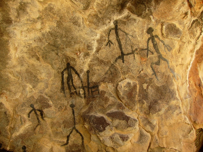
edited by surfponto on 3/18/2010
<em>edited by surfponto on 3/18/2010</em> |
3/19/2010
Topic:
The Hunt for the elusive Carrizo Gorge Pictographs
surfpontoAdministrator
|
I didn't notice the water until that big sand dropoff where the sign used to be near the end of the jeep trail.
It was really nice back there. Not a soul around for miles
The trail gave my Land-Cruiser a real work out.
Bob
hikerdmb wrote:
I see what you mean about the pictographs looking touched up. They are very dark. I like the pic of the cruiser and the creek. The hills in the background are amazingly green. That is a lot of water for Carrizo. How far down the canyon was the water flowing? Seeing the flowers makes me even more excited about my trip this weekend.
David
<em>edited by surfponto on 3/19/2010</em> |
3/19/2010
Topic:
The Hunt for the elusive Carrizo Gorge Pictographs
surfpontoAdministrator
|
Prince ! Do people still play that
That rock house is actually in the southern area of Anza Borrego. It is about a 2.7 miles each way from where park.
It looks like the build date is 1942
I am not sure the history of that one. It is in a really nice spot. It overlooks this huge valley
Not a soul around
Bob
quidditian wrote:
Oooooooooooooooooooh! What delightful pics! The cacti with pink blooms are to die for. Um, yeah, my car would be the equivalent of trying to tool around on a tricycle out there. The little horn on the handlebars could be my cell phone.
What's the little stone building? Is that just another angle of the Harper stuff, or a mine entrance, or...?
Also love the long windy road to the mountains pic...now I'll have the Beatles tune stuck in my head all night. That's preferable to the Prince in neighbor is blaring at the moment, though. :] |
3/19/2010
Topic:
Missing teen last seen in AB at Thangsgiving...
surfpontoAdministrator
|
I did read about that today.
I actually thought I might head out there to help with the search.
Weird part is the search is pretty much dead on to where we were last weekend.
I really hope he is OK.
Bob
quidditian wrote:
I'm posting this because I hadn't heard the first thing about it until today. Admittedly, I haven't been terribly up on the news since I don't get up for work, hence miss Morning Edition every day, but still thought it might be worth posting in case anyone else wasn't aware of it. Since you guys know the area(s) the article references, it never hurts to have some extra eyeballs on the lookout for any clues you might encounter on your sojourns...
http://www.nbcsandiego.com/news/local-beat/Search-Planned-for-Missing-Teen--88562227.html |
3/22/2010
Topic:
Indian Hill and June Wash
surfpontoAdministrator
|
Awesome pictures David!
Too bad about the crowds. I guess there is something to be said for trying to do a mid-week trip
Crazy that there was a troop of Boy Scouts camped there.
I think the sunrise pic is great!
Bob
hikerdmb wrote:
I finally made it to Indian Hill this weekend. I had tried to do the hike a couple weeks ago but a rainy windy day caused a short delay for this hike. It has been many years since we have hiked to the cave but it was well worth the wait. Saturday was a beautiful day, warm with a nice breeze and plenty of blue skies.
We left the crowded wash and traveled across the flats only to find the huge shelter cave full of a troop of boy scouts out for a night. So we changed course and headed for the tank. The tank was very full and my dog Wylie enjoyed a cool dip after the hike in. He is a 100 pound Golden Retriever so that should give you some idea about the depth of the water in the tank.
The view from the tank is absolutely beautiful.
After our visit to the tank we headed over to the cave and waited for most of the people to leave then climbed up and took a few pics of the beautiful pictographs inside the cave.
We then left the cave area and headed toward the Railroad camp and the old jeep trail.
We figured if we hiked back to the truck by this route it would be a little less crowded and it was. We did not see another person till we got back to the truck. Although we did hear the boy scouts having fun somewhere across the desert. We did however, see many beautiful flowers on this part of the hike.
From the Indian Hill area we drove back out to S-2 and then north to June Wash where we would spend the night. We had a great campsite and campfire and awoke to a beautiful sunrise.
Sunday was very overcast but there were plenty of flowers in this area of the park to keep my attention off the sky. I took a little stroll up a side wash off of the main June Wash and found lots of Brown Eyed Primrose,
Desert Lilies,
and lots of little yellow flowers that I think are California Suncup.
There were many other flowers in this area, Arizona Lupine, Sand Verbena, Desert Dandelions,Chicory, Desert Pincusion, a few Cholla, and more. There was also a great view of Sombrero Peak.
We finished our trip with a drive into Borrego Springs for breakfast. I have NEVER seen so many people in Borrego Springs in my 25 + years of going to ABDSP.
<em>edited by surfponto on 3/22/2010</em> |
3/23/2010
Topic:
The Hunt for the elusive Carrizo Gorge Pictographs
surfpontoAdministrator
|
Hey all,
I just added the post for this trip at http://www.anzaborrego.net
Let me know what you think?
|
3/23/2010
Topic:
The Hunt for the elusive Carrizo Gorge Pictographs
surfpontoAdministrator
|
Quite possibly.
It is a really nice cave with a great view.
Funny, now that I know where it is I can't believe I missed it.
What is weird is that the sign that used to say "Closed Area" at the end of the trail is now gone.
I was pretty turned around driving out there since I kept looking for the sign.
Let me know if you want a Google link?

Bob
hikerdmb wrote:
I like it. Makes me want to go there. I have been pretty far up that canyon but never knew there were pictographs. It seems I remember talk of a cave being used by illegals a few years ago. Maybe that is the same one.
David |
3/23/2010
Topic:
The Hunt for the elusive Carrizo Gorge Pictographs
surfpontoAdministrator
|
Funny that is one of the pictures I saw also that made me want to find them.
I think they are really cool. Almost spooky I agree though, I would prefer them untouched.
I have heard that they may have been touched up in the 40s but noone seems to have any concrete evidence either way.
I basically try to write how I think. Sometimes it works, other times not so well.
Writing is fun. Wish I had paid more attention during my college writing classes since it would have come in useful for BLOGGING
To answer your question about the pics copy and paste your image path such as
http://lh5.ggpht.com/_7UktrJ96AFU/S6LyboXAohI/AAAAAAAAAkg/kT2Wvev-TFc/s800/IMG_0276_1.jpg
Hilight it and then click on the button up top that looks like a picture (5th one from left)
Oh and whatever you could dig up about the pictographs would be awesome!
Bob
quidditian wrote:
Oh so THAT'S what these "water drops" are...you guys were talking about them in another post, and I didn't know what they were. Well, that's nice. Never one to encourage illegal behavior, but...well, I think we can all give a collective sigh here.
You've got a nice readable writing style, perfect for keeping people engaged; I'm appalled at the number of intelligent illiterates who wander the earth (or at least the internet).
About the pictographs... I guess it's sort of a big deal to me whether or not they've been retouched, so I tried to stalk out some info, but came up empty handed. I found them on another site, but the author didn't really make any qualitative statements about them. He mentions some other nice spots, though...the pictographs around the Inkopah Mountains call to me...or perhaps it's more the burial ground that's bellowing out. I know many of these are familiar to you guys...
http://home.sandiego.edu/~gennero/Petro.html
Billions and billions of years ago (thank you, C. Sagan), I bought an old Russian icon at an estate sale. It wasn't a lot of money (though $80 seemed like a million, being freshly out of college), but I loved it because it had a genuine historicity to it -- it looked like it had been dragged across countries by persecuted families for several generations. I had it appraised at one point, more interested in learning a time frame for it than its value (which is good -- it seems that when Russia fell, the market was flooded with these icons, making them relatively monetarily worthless). The owner of the antique gallery said it appeared to be late 17th century.
Anyway, the kicker about the thing is that there are some Greek letters (symbols?) that were originally in gold leaf. The letters had so worn away (as had/has much of the face of the painting) that some well-meaning person along the way went over the letters with...*shiver*...one of those god-awful gold metallic pens one finds at any craft store.
The moral of the story is that retouching (in my opinion, even when its done by museum-quality restorers) takes so much away from an object of antiquity. I'd much prefer the deteriorated/authentic state... It sort of harshly slaps one back into the present to know something has been "restored."
When I was looking around for the blue sun pigment info a couple of weeks ago, there was info out there of the types of binders used for pigments on the pictographs, and while there were a variety available, apparently it's thought the most sturdy was a binder made of bone marrow. Sap was also mentioned. Now, I've had a couple of dark encounters with sap, and it can seem like the stuff will NEVER come come off whatever it's gotten on. I can't say I've had any close encounters with bone marrow, so can't speak to its adhesive properties. I'm wondering, though, if the pictos in question are relatively newish (don't know which tribe they're attributed to), were made of a SERIOUS binding element and charcoal, AND had the added protection of being somewhat sheltered from the elements in that cave...whether they might indeed be in an unadulterated state. The five-year-old in me wants to believe that.
There must be a scholar on this area wandering around somewhere...not that they might not also have to go on speculation. I'll add it to the lengthy "sniff this out when I get a chance" list.
Great blog post, Bob -- loved the reference to people desperately snapping pics of anything with a spot of color. When I was out there, I felt bad for all of the tourists that were going to be loading in that weekend for the flowers, b/c the flowers simply weren't cooperating yet...
As an aside, how do you guys embed the full images in posts? Do I use the <img src=web link from photo host> or some variation thereof?
edited by surfponto on 3/23/2010
<em>edited by surfponto on 3/23/2010</em> |
3/25/2010
Topic:
Anza Borrego Flower Update for March 24th
surfpontoAdministrator
|
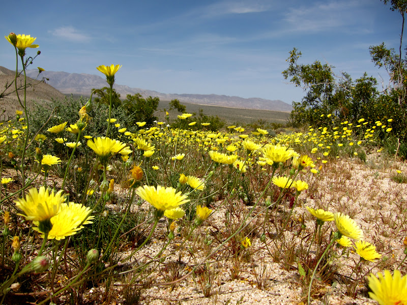
Took my sister out to Anza Borrego yesterday for a flower hunting trip.
We drove up Indian Gorge to Indian valley and then over to Egg Mountain to have lunch. Flowers were amazing!! |
3/25/2010
Topic:
Anza Borrego Flower Update for March 24th
surfpontoAdministrator
|
Egg Mountain ... you nailed it !
Have a great trip up to Yosemite. Sounds great
We are organizing a work group trip to the Mud caves in a week.
Should get some good pics.
Best,
Bob
hikerdmb wrote:
Nice shot Bob. Is that from Egg Mountain? I am hoping to head out on Monday for the day with a non desert loving friend that I have been trying to convert for a few years. He loves nature and the mountains but I can't quite get him to realize the beauty of the desert. I think it is a green thing. Then we are off to backcountry ski and camp in Yosemite for 10 days. Can't wait!!!!
David |
3/25/2010
Topic:
Anza Borrego Flower Update for March 24th
surfpontoAdministrator
|
Funny, but I prefer desert camping and hiking to the forests.
Not that they aren't nice but the Desert is wide open and usually you can see for miles.
When we camped a few years back up at Pfeiffer in Big Sur, I really didn't like it.
Sure it was beautiful but it felt closed in to me.
Not to mention there were people everywhere.
That being said, I did a Sierras backpacking trip to Heart Lake last summer and that was beautiful. I would do that again in a heartbeat.

surfponto wrote:
Egg Mountain ... you nailed it !
Have a great trip up to Yosemite. Sounds great
We are organizing a work group trip to the Mud caves in a week.
Should get some good pics.
Best,
Bob
hikerdmb wrote:
Nice shot Bob. Is that from Egg Mountain? I am hoping to head out on Monday for the day with a non desert loving friend that I have been trying to convert for a few years. He loves nature and the mountains but I can't quite get him to realize the beauty of the desert. I think it is a green thing. Then we are off to backcountry ski and camp in Yosemite for 10 days. Can't wait!!!!
David |
3/30/2010
Topic:
The Hunt for the elusive Carrizo Gorge Pictographs
surfpontoAdministrator
|
Hi Cayenne,
Thanks for doing all the research on this.
I think I may pick up that book and see what other sites I can find....due credit to oyu of course.
Regards,
Bob |
3/30/2010
Topic:
Day trip to the Arroyo Tapiado Mud Caves
surfpontoAdministrator
|
We will be haeding out to the Mud Caves in Arroyo Tapiado this coming Saturday. Haven't been out for about 5 years so we are really looking forward to it. If you have not been there before lets just say it involves a lot of crawiling, squeezing and climbing.
Also you cannot be claustrophobic or you will have trouble.
 |
3/30/2010
Topic:
Day trip to the Arroyo Tapiado Mud Caves
surfpontoAdministrator
|
Uggghh I hope it is not crowded.
last time I was there was in June 05 which tends to deter the less hardy desert hikers
Bob
hikerdmb wrote:
We drove through there earlier this winter (Januray) heading up to camp along the little cut across trail that connects Arroyo Tapiado and Arroyo Seco Del Diablo. We were shocked when we went past the mud caves area because there were at least 40 rigs parked in there. But hardly any people. I stopped and asked a guy covered in dirt what was up and he said boy scouts form the OC were exploring the caves. Must have been a couple hundred people there that day.
In the afternoon we were hiking northwest on the ridge between Arroyo Tapiado and Arroyo Seco Del Diablo and we came across an old trail coming up out of the wash and then heading up toward Whale Peak. It had huge rock cairns along it. We found 3 or 4 cairns along the trail for about half a mile or so and then it kind of just petered out. If you look in this picture you can see the cairn on the left edge of the pic and to the left of the ocotillo. The trail goes to the right of the ocotillo and off toward the center of the pic. You can see my buddy (dark spot) in the middle of the pic and the trail right by him. It was very cool. The picture is taken looking southeast toward Carrizo Creek and the Impact Area with the Coyote Mountains to the right.
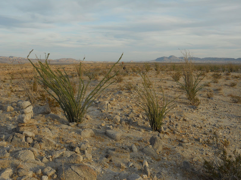 |
3/30/2010
Topic:
Return to Indian Hill
surfpontoAdministrator
|
David,
You have some awesome flower pictures!
The macro shots are amazing.
I really like the color of the globe mallows also.
Did you make it to the pictographs in Carrizo?
Bob |
3/30/2010
Topic:
Return to Indian Hill
surfpontoAdministrator
|
OK I won't tell you but you were very close to the pictographs.
How about that trail?
Like you said 4wd low range in the upper part of the gorge.
Sounds like you parked right where I did. The trial got impassable a few yards later.
There used to be a sign I believe that marked the end of the trail "Closed Area" but I think it has been washed away.
Bob
hikerdmb wrote:
Bob,
We went as far up the gorge to where the road goes down a short steep bank and crosses the creek. I think it is the same place as the pic in your post from going up there that shows your LC by the water. Although there was much less water at that crossing now than when you were there. We only went about 100 yards or so past that crossing before we turned around. It was right near this water cache.
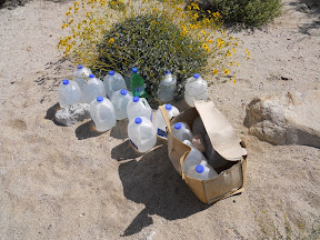
I think it is the same cache as in pic 30 from your Picasa pics from your solo trip. It looked familiar.
I am not sure how much farther the road went on from there but we needed to turn around and get back home by 5:00. How much farther from that crossing were you able to drive? It has been a bunch of years since I have been that far up the gorge and I couldn't believe how much it had changed in that time. Next time I go up that way though I will be sure to ask for some help finding the pictographs up there.
I wasn't even considering looking for the pictographs on this trip because of time constraints so please don't tell me I was only a hundred yards from them. Lots of good 4 low driving in the upper part of the gorge. FUN!
David |
4/5/2010
Topic:
Day trip to the Arroyo Tapiado Mud Caves
surfpontoAdministrator
|
It was a great trip. As David said it was a bit busy in the main caves .
I forgot how fun this area is. Temperature differences were amazing. I would like to go back and do a mid-week trip at some point.
Bob |
4/5/2010
Topic:
Return to Indian Hill
surfpontoAdministrator
|
Just got an email from the DzrtGrls over at http://www.dzrtgrls.com.
They were able to find the Carrizo Gorge pictographs from my description.
They said they were enjoying the solitude until 7 Jeeps came roaring up Carrizo Gorge. |
4/5/2010
Topic:
Anza Borrego Mud Caves at Arroyo Tapiado
surfpontoAdministrator
|
We had a fun group trip to the Arroyo Tapiado Mud caves. Hidden Cave is awesome. You basically slither along some of the passages like a snake until it opens up in rooms that you can stand up in.
I have a post update at lhttp://www.anzaborrego.net
 |
4/5/2010
Topic:
Return to Indian Hill
surfpontoAdministrator
|
My thought exactly
I think those rocks are pretty solid. I would be more concerned being inside one of the mud caves during a 7.2 earthquake.
Some areas of the caves seem a little precarious.
Bob
quidditian wrote:
Not directed toward the desert girls, but to 7 jeeps -- ew?
Annoying question:
Was wondering -- with the quake we had today, which was quite fascinating, since it's the strongest I've felt (and I usually don't feel them at all) -- is that enough to shake and shift the rocks off the mountains when on is driving the narrow roads?
Not that I'm looking for another excuse to avoid driving...buuuuut.... I love how precariously they're all balanced. Am wondering just how precarious it all is...
|
4/6/2010
Topic:
Return to Indian Hill
surfpontoAdministrator
|
Pic
Looks like it has to go between the tags since that is a link.
I was able to copy the actual image location at farm3.static.flickr.com/2729/4493754206_15a94e8941.jpg

<em>edited by surfponto on 4/6/2010</em> |
4/12/2010
Topic:
Anza Borrego Mud Caves at Arroyo Tapiado
surfpontoAdministrator
|
Hey David,
Welcome back.
Yeah it was a fun trip. Guess we missed the earthquake by a day.
Apparently the Fish Creek Sandstone canyon area received some damage.
It would not have wanted to been inside the mud caves during that shake.
hikerdmb wrote:
Bob,
I read the trip report on the website. Looks like it was kind of warm and you had a good sized group too. Nice pics. That is a nice portable grill too.
I missed the desert while I was gone but it is tough to beat backcountry skiing in Yosemite. I will send you a link to the pics when I get them up but I think it will be a while.
David
<em>edited by surfponto on 4/12/2010</em> |
4/12/2010
Topic:
Piepkorn slot
surfpontoAdministrator
|
Hi and welcome,
Have not heard of him. I will see if I can find out some information though.
Bob
blueskymut wrote:
Does anyone know any details about Mark Piepkorn of Piepkorn slot? Such as, How did he die?,Where was he from?, How old was he and where is he buried? Thank you for the great site. |
4/12/2010
Topic:
Piepkorn slot
surfpontoAdministrator
|
Hey again,
I am just realizing that I have been over there and have seen some sort of memorial.
Now I am intrigued.
I will see what I can find out.
Bob
blueskymut wrote:
Does anyone know any details about Mark Piepkorn of Piepkorn slot? Such as, How did he die?,Where was he from?, How old was he and where is he buried? Thank you for the great site. |
4/12/2010
Topic:
Anza Borrego Mud Caves at Arroyo Tapiado
surfpontoAdministrator
|
No it was forwarded to me from www.Dzrtgrls.com
She found it on this forum.
hikerdmb wrote:
Bob,
Is that pic from after the quake? Did you go out there and find this? As Aron Ralston said after he got stuck between the rock and the wall, something like, "Geologic time in now."
David
<em>edited by surfponto on 4/12/2010</em> |
4/16/2010
Topic:
Pinyon Ridge
surfpontoAdministrator
|
Awesome
Please be sure to post your trip report.
How long is the hike?
We are going to hike to Goat canyon Trestle on Saturday or Sunday
Have you done the route from Indian Hill? |
4/16/2010
Topic:
Carrizo Gorge Post made it to the San Diego Reader
surfpontoAdministrator
|
Not to brag or anything but I submitted my Carrizo Gorge Pictographs post to the San Diego Reader and they actually printed it.
Had I known they were going to actually print it I probably would have cleaned up some of the grammar.
Link to San Diego Reader article Desert Treasure |
4/16/2010
Topic:
Pinyon Ridge
surfpontoAdministrator
|
Hi david,
That is the part I am interested in. When you said you followed the tracks back to Indian Hill do you mean to the end of the area where you can drive past Indian Hill and park?
I would kind of like to hike along the tracks but I am concerned we may get ticketed.
What are your thoughts.
Your hike sounds great and a lot cooler *temperature wise.
Bob
hikerdmb wrote:
Bob,
The hike to Pinyon Ridge is about 5 miles each way. It is a very up and down hike with a little more up than down on the way in. Once out there I will camp amongst Pinyon Pine trees and have a terrific view down onto Borrego Springs and out to the Salton Sea. It is a fun hike and you can even climb Wilson Peak once out to the end of the trail. Wilson Peak is not too much of a climb but there is a register on top to sign and a nice 360 degree view.
I have been to the trestle once. We climbed up past Mortero Palms and then down to the trestle. We followed the train tracks down hill and then came back through Indian Hill to the road and hiked back to our truck at Mortero Palms. I think we figured it was about 13 miles or so. The best part was when we got out of the Indian Hill area a guy came by in a truck and offered us a ride for about a mile and also a very very cold Coors Light. My friend almost fell off the back of the tailgate as we got our free ride/beer but it was worth it. I have also hiked through Indian Hill and the RR camp and out toward the trestle but we stopped when we got to a place with a good view of Goat Canyon. It was very cool hiking through the tunnels and I remember on our way back you leave Carrizo Gorge and come through a tunnel and when you come out of the tunnel you are in the Indian Hill side again. It was a very dramatic change of scenery. Hopefully you can get through the tunnels. We had to crawl under a couple of gates to get through one or two of them.
Have a great hike and I hope it is not too hot down there this weekend.
David |
4/16/2010
Topic:
Carrizo Gorge Post made it to the San Diego Reader
surfpontoAdministrator
|
Last weeks Reader with the crazy Bulls eye face on the cover.
hikerdmb wrote:
Good job Bob! That is great!! Is it in the reader that came out this week?
edited by hikerdmb on 4/16/2010 |
4/18/2010
Topic:
Pinyon Ridge
surfpontoAdministrator
|
Thanks David,
Our trip fell through.
I am shooting again for next weekend or possibly a mid-week trek out there.
Hope your Backpacking trip went well
Bob |
4/18/2010
Topic:
Pinyon Ridge
surfpontoAdministrator
|
Great David,
Look forward to your pictures and report.
Bob
hikerdmb wrote:
Bob,
Sorry your plans fell through. Just got home an hour or so ago and had a great time. I will post some pictures and a trip report later.
David |
4/19/2010
Topic:
Pinyon Ridge Solo Backpack Trip
surfpontoAdministrator
|
Excellent trip report David,
It makes me want to head out there and do that hike.
You have some great pictures also.
If it is OK I may post this to the anzaborrego.net posts also for people to read
Bob |
4/19/2010
Topic:
Pinyon Ridge Solo Backpack Trip
surfpontoAdministrator
|
Hi David,
Gave your post center billing on my BLOG.
Your Picasa pictures are great.
Bob |
4/21/2010
Topic:
Hiking to Goat Canyon Trestle
surfpontoAdministrator
|
Hey Daren,
The link works for me.
Those rattlesnake pictures are great!
Looks like you were pretty close unless you had a good zoom lens
I actually just got back from Dos Cabezas. I had planned to solo hike from Mortero Palms to the Trestle but the weather kind of messsed up my plans.
When I opened the door of my landCruiser the wind almost blew it off.... :-0
There were also the occasional rain squalls blowing over the mountains so I decided to leave it for another day.
Bob
dsefcik wrote:
hikerdmb wrote:
Daren,
That looks like a long and rugged hike through some pretty incredible terrain. However when I click on your link I get a blank page. Can you check that? I would like to see more details about this trip.
David
Maybe I just messed up the url tag, I edited it and seems to work now. If not just copy/paste this url into your browser
http://www.sefcik.com/index.php/2010/04/19/sacatone-overlook-to-goat-canyon-hike
<em>edited by surfponto on 4/21/2010</em> |
4/22/2010
Topic:
Hiking to Goat Canyon Trestle
surfpontoAdministrator
|
That would be awesome if you could post those.
My wife and I are talking about heading out next Thursday to hike in from Carrizo Gorge
True the Google Earth images can be misleading. :-)
Bob
dsefcik wrote:
surfponto wrote:
Hey Daren,
The link works for me.
Those rattlesnake pictures are great!
Looks like you were pretty close unless you had a good zoom lens
I actually just got back from Dos Cabezas. I had planned to solo hike from Mortero Palms to the Trestle but the weather kind of messsed up my plans.
When I opened the door of my landCruiser the wind almost blew it off.... :-0
There were also the occasional rain squalls blowing over the mountains so I decided to leave it for another day.
Bob
I was within a few feet of both them but I ran as soon as I heard them rattle. Scott stepped up and took the pictures, he had a zoom camera and stayed a good 15' feet or so back. The canyon that leads up to the trestle has a very steep rock face at the bottom, almost dry fall'ish like. You can see it in Google Earth, barely. There is another way or two up from the gorge. I will draw up a few maps and post them to see if anybody is interested in trying them.
Daren |
4/24/2010
Topic:
Hiking to Goat Canyon Trestle
surfpontoAdministrator
|
That is awesome.
Really puts the whole thing in perspective. Not sure my wife would want to do the hike from Sacatone overlook.
I convinced her we can do it from the South end of Carrizo Gorge and I am anticipating about 3 miles one way from where we park.
I am going to do a better job setting waypoints this time since on our last attempt a couple years ago we got a bit lost.
Carrizo Gorge To Goat Canyon
We are thinking leaving early Thursday if nothing comes up at work before then. You are welcome to join us.
<em>edited by surfponto on 4/24/2010</em> |
4/24/2010
Topic:
Hiking to Goat Canyon Trestle
surfpontoAdministrator
|
Meant to ask. Is that the standard Google earth you are using? It looks better than mine |
4/24/2010
Topic:
Hiking to Goat Canyon Trestle
surfpontoAdministrator
|
Thanks,
I like that idea of using the utility road. I have heard about the dry waterfalla t the mouth of Goat Canyon. I head it is hard but not insurmountable.
Your maps have been very helpful.
I honestly don't know how much time to allow for this?
We wanted to get an early start but that means leaving Leucadia araound 7AM.
Bob |
4/24/2010
Topic:
Hiking to Goat Canyon Trestle
surfpontoAdministrator
|
Sorry you are correct. I meant the north end.
We drive up Carrizo Gorge from the S2
I can get as far as the creek drop off in my LandCruiser
Bob
dsefcik wrote:
surfponto wrote:
That is awesome.
I convinced her we can do it from the South end of Carrizo Gorge and I am anticipating about 3 miles one way from where we park.
edited by surfponto on 4/24/2010
Do you mean the "north" end? If the south, where are you parking? |
5/2/2010
Topic:
Hiking to Goat Canyon Trestle
surfpontoAdministrator
|
Great hike yesterday Daren,
I am still picking cholla spines out of my %$#@
I will post up some pics and a trip report soon.
Bob
dsefcik wrote:
surfponto wrote:
That is awesome.
I convinced her we can do it from the North end of Carrizo Gorge and I am anticipating about 3 miles one way from where we park.
edited by surfponto on 4/24/2010
Do you mean the "north" end? If the south, where are you parking?
edited by surfponto on 4/24/2010 |
5/2/2010
Topic:
Carrizo Gorge East Fork to Carrizo Palms
surfpontoAdministrator
|
Hey David,
That was the hike we did last year.
My friends liked it , but underestimated the amount of water they needed :-)
We ended up hiking to Goat Canyon yesterday. Haven't written the post but here are the pics.
Goat Canyon Hike
regards,
Bob
hikerdmb wrote:
Bob,
Nice hike. Looks warm. I take it you did this hike instead of the hike to the trestle you had mentioned for last Thursday. It looked REALLY windy on Thursday last week, 40+ gusts. How did the "newbies" like the desert? And did you really say last trip of the season?
David |