1/15/2011
Topic:
El Cajon Peak (AKA El Capitan Mtn) Hike
dsefcikAdministrator
|
The "edge" aka El Cap was on my agenda but I got a late start and did not want to risk having the parking lot gate locked on me. I am totally up for another trip out to try and get there. Anyone else..?? |
1/18/2011
Topic:
El Cajon Peak (AKA El Capitan Mtn) Hike
dsefcikAdministrator
|
Sure..just let me know..
surfponto wrote:
Hey Daren
I would be up for it.
This weekend is not good. My son and I are getting our SCUBA cer this weekend 
Maybe in a couple weeks?
Bob |
1/18/2011
Topic:
Indian Valley
dsefcikAdministrator
|
Nice TR and great pics David..! The ram pic is nice, interesting he was alone AND resting. I can see in your pics that is the spot where I camped with my son at Thanksgiving and I can see the mound of boulders where the hunting blind and some morteros were that I saw, did you go climb and try to find it?
My son and I and 'Bones our dog went out for the weekend also, I will post a TR soon.
BTW, that snow pic looks like the story of when you got stuck..is that it??
-- |
1/18/2011
Topic:
Jacumba Wilderness
dsefcikAdministrator
|
spaugh wrote:
just an FYI, those pictures posted are not of pinto canyon. I know the area where those were taken and they are smugglers cave and some other oasis near I8 and mountain spring. There won't be trash like that in pinto canyon or davies valley. They are further off the beaten track. The only people in davies or pinto are boarder patrol and international travelers.
You are probably correct technically...his post,pics and topo map show he descended down Myer Valley and did not go into Pinto Canyon. He mentions a "cliff" deterred him from going down into Pinto Canyon.
Thanks for the clarification.
Daren

-- |
1/19/2011
Topic:
Nude Wash & Sky Art Sculptures
dsefcikAdministrator
|
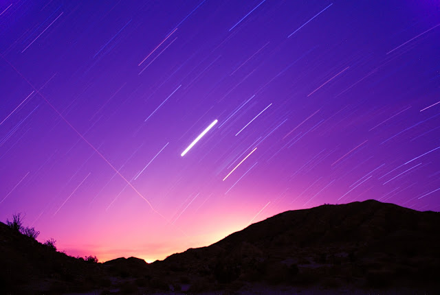
My son and I took a 3 day trip out over the MLK weekend break. A full report is on my website here:
http://www.sefcik.com/2011/01/nude-wash-sky-art-sculptures-abdsp.html
It was a great trip of easy going, campfire, hanging out and playing with my (new to me) camera. Here a few pics, see my website for more:
Some Sky Art


A lizard at the visitor center
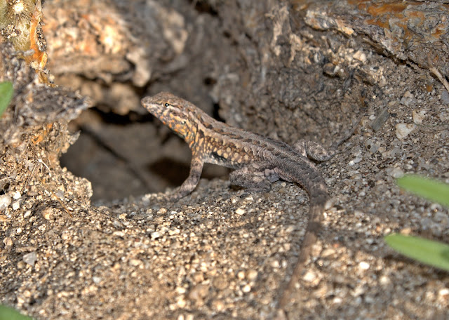
Some Cholla near Mine Wash

'Bones our dog scouting for kangaroo mice
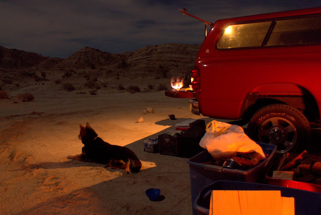
17 Palms Oasis

Another attempt at star trails, the bright star is Venus, this was about 4;30am
-- |
1/19/2011
Topic:
Nude Wash & Sky Art Sculptures
dsefcikAdministrator
|
We saw pretty much all of the sculptures I thought existed. When we got home and I looked up the galleta meadows website I saw there were 2 bighorn rams and the juan bautista sculptures we did not see..guess that means another trip out..
I bought a mostly new sony a300 with extra lenses and all the trimmings..it was something I could afford. Any of the Canons or Nikons were 2-3 hundred more (used) so I will learn with this one. I already had a tripod and is definitely needed. I am just happy I can take night photos again..!
-- |
1/19/2011
Topic:
Plane Wrecks
dsefcikAdministrator
|
http://joeidoni.smugmug.com/Aircraft-Crash-Sites/A/11558268_JnGUE#818002961_s9gHV
OK, this got my attention....I have not (so far) found much more info about it. I would love to try and find this site. Anybody else know much more about it?
--
<em>edited by dsefcik on 1/19/2011</em> |
1/21/2011
Topic:
Nude Wash & Sky Art Sculptures
dsefcikAdministrator
|
It can use the AF lenses. Basically Sony bought Minolta so a lot of the Sony camera stuff is Minolta at the core. What kinda lenses you got? You wanna sell? |
1/21/2011
Topic:
Plane Wrecks
dsefcikAdministrator
|
No, not convinced but I did see that also and is worth a trip to find out. His site has a number of different wreck sites in ABDSP that are worth looking into further. I think you are right about the north end though.
When I was driving back with my son last weekend I noticed a VERY bright and large shiny object or reflection of something on one the Laguna ridges. It was not near a trail or anything, it was in a deep ravine and both my son and I were trying to figure out what it might be. I thought maybe a car wreck or something but it really was way too far away from anything to be a car, an airplane wreck never crossed my mind until I saw this guy's pictures. |
1/23/2011
Topic:
Backpacking through Jackass Flat and Dry Wash
dsefcikAdministrator
|
Looks pretty sweet David, I almost went out again this weekend but decided to stay home and hang out with the kids and the dog instead. Next weekend should be close to a new moon and I was thinking of either backpacking out to Innner Pasture or up Sunset Mtn via Sunset wash...are you interested in going out next weekend?
BTW, looks like you are starting to get into the GE thing...looks good. |
1/24/2011
Topic:
Backpacking through Jackass Flat and Dry Wash
dsefcikAdministrator
|
Another good trip would be to start at the same place you did and hike out thru RHC and when you get out to the valley cut east and circle back towards corps 395 and then up to the road. A two car setup might make this easier but both would need to be able to reach the trail head of hidden springs to avoid hiking another 3 miles up the wash.
-- |
1/25/2011
Topic:
Backpacking through Jackass Flat and Dry Wash
dsefcikAdministrator
|
Hey David, do you think my bigass truck would make it out to the trail head at hidden springs? |
1/25/2011
Topic:
Backpacking through Jackass Flat and Dry Wash
dsefcikAdministrator
|
Sweet, thanks for the info guys..the trail descriptions you give seem to reflect other info I have found on the Internet. Since I have pretty much already ruined the paint and dented up the right rear quarter panel from trips with Bob when he said "you can make it, no problem" I would be willing to drive out and try...I can always stop if it gets too sketchy. I think I tend to worry more about deep sand & mud, I really don't want to try and dig out my 4-1/2 ton truck. |
1/25/2011
Topic:
Backpacking through Jackass Flat and Dry Wash
dsefcikAdministrator
|
Hey David, did you actually use a gps to record your tracks or did you just sketch in freehand the google earth tracks? Also, looks like Wiley made it out with you again..nice.. |
1/25/2011
Topic:
Backpacking through Jackass Flat and Dry Wash
dsefcikAdministrator
|
A friend of mine wants to do a 3 day trip in March and I am thinking some variation of rockhouse valley so I will probably be driving up it then as long as the weather doesn't wash it out again.
Thanks guys!! |
1/28/2011
Topic:
National Geographic WeekendExplorer 3D
dsefcikAdministrator
|
I have not, I have a hard time spending money on that kind of stuff when I can get topo's for free and use GE. I do have Mapsource with the paid version of Garmin topo series and I still go back to GE. |
1/28/2011
Topic:
National Geographic WeekendExplorer 3D
dsefcikAdministrator
|
http://libremap.org/data/state/california/ |
1/28/2011
Topic:
National Geographic WeekendExplorer 3D
dsefcikAdministrator
|
I use the free version of GE. |
1/28/2011
Topic:
National Geographic WeekendExplorer 3D
dsefcikAdministrator
|
ALso, another interesting thing is overlaying topo maps in GE. I have been using the maps from this post: http://www.gearthblog.com/blog/archives/2006/03/best_topo_map_i.html but have also seen this post which looks interesting. |
2/1/2011
Topic:
Old Carrizo Stage Station
dsefcikAdministrator
|
Where is this more or less? |
2/2/2011
Topic:
Jacumba Mountains Area Day Trip
dsefcikAdministrator
|
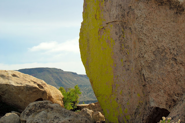
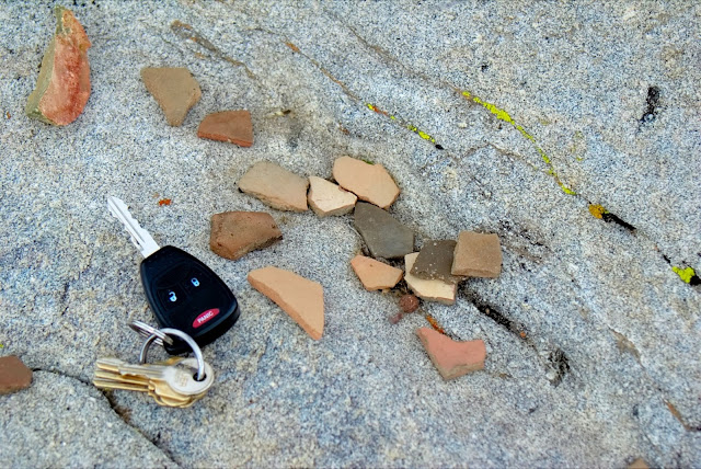
A friend of mine and I headed out to the Jacumba mountains area to hike down to Carrizo Gorge and explore some of the old train parts abandoned when the Carrizo Gorge railway was built. Turned out after my slow, sissy 4WD driving skills in my big Dodge crew cab truck were done we had spent most of the day stopping and exploring the surrounding area of the Jacumba Mountains and never made it down into the gorge. There were some interesting things to see along the way but I still want to go back and hike down into the gorge to find the old train parts and the abandoned railway camp.
The "full" TR is on my website http://www.sefcik.com/2011/02/jacumba-mountains.html
I am feeling pretty lazy so here are just a few pics
A wildlife guzzler
A possible old hunting blind. This whole area is near Table mtn and Sqaw Tit so it is Shaman's land

Brilliant bright yellow moss on the boulders
Pottery pieces found near the morteros
My sissy 4WD skills stopped me here

The Lindsay book describes an "Ornate stone cabin with a tin roof", here it is

-- |
2/3/2011
Topic:
Bow Willow
dsefcikAdministrator
|
I like the clouds, another thing I need to learn more about. That old sign is pretty cool also, you can see where they have pounded it in right on the top. Can you tell us where that sign was more or less? I wonder if it was part of a bigger trail system. Nice shot of the plants also. |
2/3/2011
Topic:
Jacumba Mountains Area Day Trip
dsefcikAdministrator
|
hikerdmb wrote:
Daren,
That looks like an interesting area with lots of native artifacts. I checked out the other pics on your site. The rock work on the possible hunting blind looks cool. You seem to find these features pretty regularly. What makes you say it was in Shaman's land? Good place to park the truck. That looks rough in the photo so it must look really rough in person. Sometimes the long wheel base is a bad thing.
David
Table mtn is referenced as a sacred area in many publications, including the Lindsay book. A couple of resources can be read here:
http://www.kumeyaaymapping.com/placenames-map.html
Lindsay Book at Google
http://www.copswiki.com/w/pub/Common/AnthropologyOfPotreroSite/Kuuchamaa-The_Kumeyaay_Sacred_Mountain.pdf
The rocky section of the trail was steep and narrow, my truck was certain to sustain some type of damage if I had tried to go down it. Since we were only about 1/2 mile away from where were gonna park anyway I decided not to chance it. Given no choice I am sure we could have gone down but back up may have been a problem.
I have an old post of a hike up Table mtn here: http://www.sefcik.com/2010/03/squaw-tit-to-table-mtn.html
--
<em>edited by dsefcik on 2/3/2011</em> |
2/4/2011
Topic:
Jacumba Mountains Area Day Trip
dsefcikAdministrator
|
surfponto wrote:
Great pics Daren,
I would like to explore some of the old railroad artifacts at some point.
I think your truck would have made it down those rocks by the way
What's the story on that rock cabin?
Bob
I don't know much about the cabin, it was a brief mention in the Lindsay book and to be honest it was kinda hidden, we almost missed it..well I did, Scott my friend found it. It was right near the quarry so my guess is old miners built and used it. There were numerous artifacts like an old gas stove so it was not too old, maybe early to mid 1900.
I am certain that my truck could have navigated the road in skilled hands. I am just not there yet, I am still testing the waters with the truck and my own skills. It was steep and narrow, you can see all of the tire rub marks on the rocks and the whole center was piled up with rocks from people trying to get down it.
Enough about my trip out, how was Carrizo??
-- |
2/4/2011
Topic:
Attemp to find the old Carrizo Stage Station
dsefcikAdministrator
|
I like the frozen pictures, that same night the water pipes in my house froze..damn cold here in SD. What exactly is supposed to be at the old station? Also, how is that road down into Canyon Sin Nombre, could my truck do it? or too sandy? I only have vague memories of that canyon, my dog got bit by a rattlesnake there and died within minutes, that was about 20 years ago and I have not since ventured in. |
2/5/2011
Topic:
Attemp to find the old Carrizo Stage Station
dsefcikAdministrator
|
Those are great links David, thanks! |
2/5/2011
Topic:
Attemp to find the old Carrizo Stage Station
dsefcikAdministrator
|
Bob, if you are free today, I am gonna go walk my dog and then head back out to try and find the train parts today. I suppose I could do the train station instead, is that what you are asking?? |
2/6/2011
Topic:
Carrizo Gorge Old Railway Train Parts
dsefcikAdministrator
|
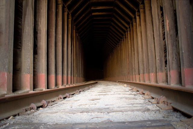
Wow! This was probably the most pristine and beautiful canyon/wash area I have ever hiked in the ABDSP area. When I first turned off the jeep trail and started hiking down the canyon I was memorized. I felt as if I was the only human to have ever walked thru it. I felt guilty of polluting it with my foot steps. Many, many animal tracks could be seen. Rabbit, Bighorn Sheep, Coyote, Mountain Lion, etc all were there. The 2.5 miles of canyon consisted of section after section of flat sandy wash with a dry fall at the end. Towards the middle of the canyon it was becoming too difficult to navigate with my big camera in my hands and I decided to put it in my backpack. No sooner did I click the waist buckle closed did I hear a sound up to my left. I looked up and less than '50 away was a Bighorn Ram staring straight at me. I knew if I moved he would run. He was big and had some major damage to his right leg area. I could see a lot of the fur was gone and there was a long black section of maybe scar or scab healing. After maybe 2-3 seconds of staring he bolted..gone up the rocky ridge, I never saw him or any other Bighorn that day. Eventually I got to the end of the canyon and to my surprise was an old train section consisting of three passenger cars and one caboose. The caboose was from Mexico and the passenger cars were form Montreal. The pastel greens inside the passenger cars were pretty funky and the brilliant,flashy colors of the Mexican caboose brought memorable images of past Mexico trips to my mind. After finally reaching the tracks and seeing the old railway pieces down in the gorge I realized I was almost out of time and needed to head back. I fast tracked down the gorge, fought the catclaw, took some pictures and headed back. I made good time going back and was able to get on the freeway by 5pm.
Please see the full trip report on my website http://www.sefcik.com/2011/02/carrizo-gorge-old-railway-train-parts.html


--
<em>edited by dsefcik on 2/6/2011</em> |
2/8/2011
Topic:
Carrizo Gorge Old Railway Train Parts
dsefcikAdministrator
|
Not only were they clearing land north of the freeway in McCain Valley they were also clearing land near the Jacumba off ramp. Both sites had large boom type vehicles onsite. There were also numerous signs near Alpine about SDGE doing construction. These were clearly areas designated on the SDG&E SPL map.
Fortunately though the map bypasses the area I describe in this post 8
ughhh...
http://www.sdge.com/sunrisepowerlink/construction_updates.html |
2/8/2011
Topic:
Bighorn Pictures
dsefcikAdministrator
|
Found this site tonight, amazing pictures!
http://www.loricareyphoto.com/gallery/2973402_DUveF#209484782_txfn2 |
2/9/2011
Topic:
Bighorn Pictures
dsefcikAdministrator
|
That is a nice shot Bob..! |
2/14/2011
Topic:
Peak 6582 redux
dsefcikAdministrator
|
I have planned it many times but never executed. How about this weekend? Sat/Sun/Mon ? |
2/14/2011
Topic:
Peak 6582 redux
dsefcikAdministrator
|
stewart wrote:
Here's the link:
http://technopeasant.org/
click on ANZA 2000
Not too many photos, had my first digital camera along, a 1.2 megapixel.
Those are great pictures!
I think you have motivated me to go. The idea of bringing water and stashing it 1/2 or 3/4 of the way was already in my plans. Spring break is definitely a possibility of going up. Let us know more about what you may be planning. I may still try this weekend despite the rain forecast.
Daren |
2/15/2011
Topic:
Peak 6582 redux
dsefcikAdministrator
|
Hey Stewart, thanks for all the info..it is very helpful. I had planed a trip out the 19th with a friend of mine and we were thinking of doing the full Rockhouse Valley tour. He may be up for 6582 instead. The full moon that weekend is actually at 11am so I think we would still be good for a dark night. We are probably gonna drive out Friday and camp at CDL and then hike/backpack Sat/Sun and drive home Sunday. I know I wouldn't mind poking around the whole area between Corp 979 and Rockhouse Canyon. A full loop thru there might be interesting also.
So barring any horrible weather we will be out there that weekend, lets try to meet up and hopefully hike out together.
Daren
<em>edited by dsefcik on 2/15/2011</em> |
2/15/2011
Topic:
Peak 6582 redux
dsefcikAdministrator
|
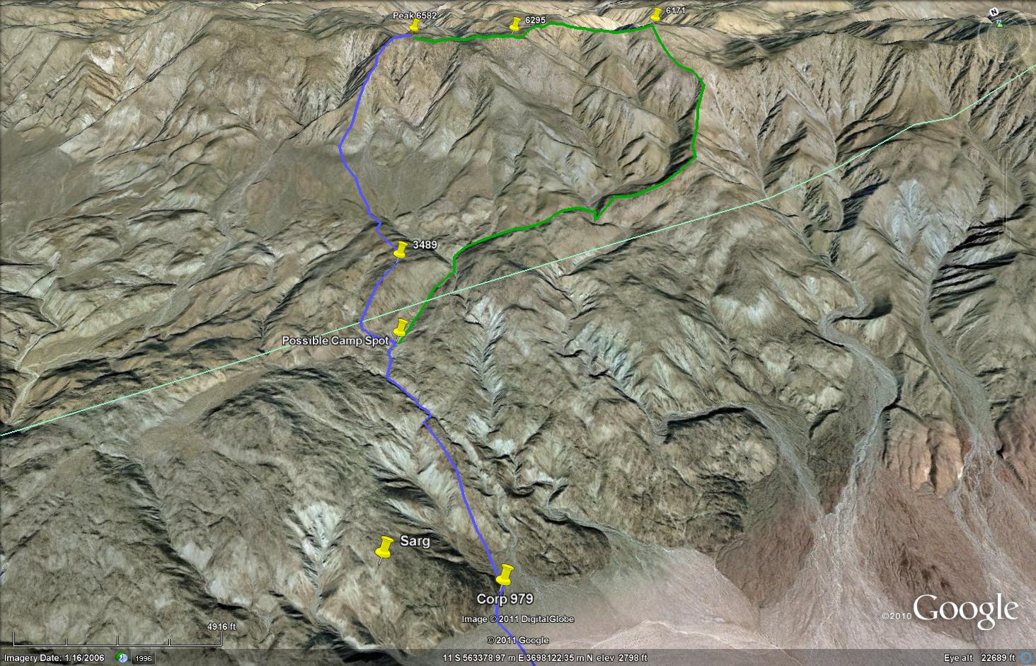
Here is a pic of the route I had sketched out last year and was almost certain it followed Schads course description. My path is in blue, I added your path described in green, does that look accurate to you?
I create these routes in google earth by overlaying a topo map on the terrain, they are fairly accurate (or at least have been so far for me).
 |
2/16/2011
Topic:
Peak 6582 redux
dsefcikAdministrator
|
Just saw this: http://theabf.org/event/archaeology_and_history/clark_lake_petroglyphs_0
Looks like a group will be out on the 20th exploring the glyphs in the area. No sure if I consider that good or bad...humm.. |
2/22/2011
Topic:
Mysterious Handprint Pictographs at Piedras Grande
dsefcikAdministrator
|
Nice pictures Bob!
I think we missed each other, I was camping with my son Sat/Sun/Mon near Indian Gorge, will post some pics and a TR soon. |
2/22/2011
Topic:
Truck Camper on Truckhaven Trail
dsefcikAdministrator
|
Those are great pictures and I like how you took time to name all of the flowers, what do use as a reference or do you just know them all????
Seems this was a popular weekend for many people to get out and enjoy the desert, my son and I also camped out Sat/Sun/Mon, I will post a TR soon.
Thanks for calling peak 6582 "Daren's Mtn"..I like that..!! haha.. |
2/22/2011
Topic:
Clark Valley Petroglyphs
dsefcikAdministrator
|
Missy wrote:
Found the petroglyphs in Clark Valley about 2 yrs ago-- they were in much better condition than I'd heard, but it took a while to find that Corp marker!! We also found lots of pottery and an old 50mm casing. I'd post pics from our trip out there but I don't know how... so I added them to a Photobucket album- http://s29.photobucket.com/albums/c283/SoCalDiveGirl/Anza%20Borrego%202009/
Thanks for sharing those photos! Looks like you were able to visit many different areas of the park, Indian Hill included. |
2/22/2011
Topic:
Truck Camper on Truckhaven Trail
dsefcikAdministrator
|
I am wondering if we should just make it a group party for the 19th and hike peak 6582 once and for all.... |
2/22/2011
Topic:
Torote Canyon / Indian Valley
dsefcikAdministrator
|
The 3 day Presidents weekend brought a lot of visitors to Anza Borrego as well as the adjacent BLM lands. Our original plan was to camp and hike Painted Gorge. When my son and I arrived at the Painted Gorge trail head there were many OHV / RV users and also several groups target shooting near by so we decided to move on and head to Anza Borrego instead. Shifting gears and making a new 3 day plan we decided to camp at the base of Indian Gorge so I could try and capture some moonrise/sunrise pictures from the valley. This would also let us hike Torote Canyon the next morning. We hiked the full 9.8 mile loop thru the canyon, over the saddle near Indian (North) Valley and then back down to our campsite. We saw several other campers over the 3 days but none in the canyon where we hiked. The park rangers were also out and about, one ranger stopped and checked our metal fire container, ash cleanup bucket and also our dog being "leashed at all times". We had everything covered so we got a friendly smile and a "have a nice day" remark. The snow in the Laguna mountains was also a surprise vista.
My full Trip Report with all pictures is on my website http://www.sefcik.com/2011/02/torote-canyon-indian-valley-abdsp.html
Whale Peak had some snow for about half of Sunday morning

Another Honey Bee shot on Desert Lavender

"Cactus Hill" in Torote Canyon

We saw some Prairie Falcons in the canyon

Looking down into Indian Valley (North) from the canyon saddle. You can see Sombrero Peak in the far distance

Sunrise on the Coyote Mtns. These colors lasted about 15 seconds

The Laguna Mountains covered in snow viewed from the Domelands area

"Fred" our Drag Queen Alien makes his debut in Anza Borrego (Thanks Cayenne!)

Our GPS tracks of Torote Canyon

-- |
2/23/2011
Topic:
Torote Canyon / Indian Valley
dsefcikAdministrator
|
hikerdmb wrote:
Daren,
Looks like a nice hike. How was the terrain getting from Torote over to Indian Valley? Did you see any nice campsites up that way? I have never been up Torote
Canyon. I have thought about it many times but there always seems to be lots of vehicles at the trailhead. Got any more pics?
David
Plenty of camp spots, the saddle area is wide open, sandy and flat..really gorgeous. Perfect for backpacking. I will try to post some more pics tonight.
Daren |
2/23/2011
Topic:
Torote Canyon / Indian Valley
dsefcikAdministrator
|
David, the terrain up the canyon is mostly sandy wash. There are a few places where you will need to boulder climb or find a way around on the hillside. The descent into Indian Gorge was steep but easily navigated despite all of the cholla cactus balls. We did take our (100lb) dog on the route and we had to airlift him over boulders in several places and also stop to pull out cactus balls from his paws. Keep this in mind if you want to take Wiley (sorry if I keep getting his name spelled wrong).
The canyon would be a great backpack trip for a 4 mile out/4 mile back trip, camping up at the saddle before descending down into Indian Valley. The are plenty of sandy areas for camp, it was very peaceful when we went and we did not see anybody out there although we did numerous footprints, an obviously popular hike.
Here are a few more pics from the canyon area
Up near the saddle area, big wide open sandy areas are plentiful (Sombrero Peak in the background)

A couple more big sandy areas

-

My son and 'Bones our dog resting in the 60 degree "heat"

Up near the saddle looking east at the Coyote Mtns I believe
My original,original plan to backpack solo before my son said he wanted to go. Park at Palm Mtn primitive campground, hike the old Indian trail over to Torote Canyon, down into Inner Pasture and try to find the indian hunting blind and other Indian remnants. 10 miles each way.

-- |
2/23/2011
Topic:
Torote Canyon / Indian Valley
dsefcikAdministrator
|
hikerdmb wrote:
Thanks Daren. I like the first pic in your last post. Looks like a nice high place with a good view. Is that right before dropping into Indian Valley? I also like those fancy hiking shoes your son is wearing.
David
Yes, it is near the high spot before dropping into Indian Valley. There are tons of flat sandy spots up there, it is really nice and wide open..I really liked it up there.
You can see from the serious hiking apparel my son uses why our hiking/camping plans change so dramatically when he wants to go along. I always have to remind him to *bring* shoes and not just flip-flops. He forgot his hydration pack on this trip, good thing I carry 50lbs of crap all the time. My 6 liter CamelBak and 6 bottles of water lasted all day for he, my dog and I...sigh...but I am happy he wants to go along! |
3/8/2011
Topic:
Desert Wildflowers and the caves of Inner Pasture
dsefcikAdministrator
|
That was a great hike out Bob, I am glad you and Mary were able to endure my day long ramblings and constant breaks to photograph animal poop...
I will post some pics and a TR soon..!
Daren |
3/9/2011
Topic:
Indian Valley North / Inner Psture
dsefcikAdministrator
|
A few days out in the desert is always a peaceful break, this last weekend was no exception. Saturday and Sunday were absolutely gorgeous and I was able to explore some remote areas of ABDSP with Bob and Mary.
A full Trip Report is on my website http://www.sefcik.com/2011/03/indian-valley-inner-pasture-abdsp.html
I stole most of the flower names from Bob and the rest I made up..8-)
Here are a few pics, I posted more than 50 on the trip report linked above
Honey Bee enjoying a Chupa Rosa Bloom. This particular bee has an almost empty pollen sac, you can see on her leg the small amount she has collected so far.
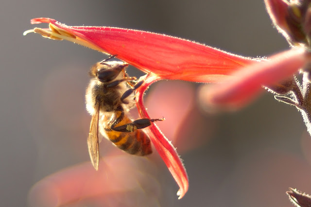
This bee has a filled pollen sac, you can see the large yellow mass on her leg.

Ocotillo Bloom

Wallace Wooly Daisy, there is a small spider in there also.

Massive Mountain Lion Scat

Yellow Backed Spiny Lizard

Our Pottery collection

Cool Cave colors

Bones in poop

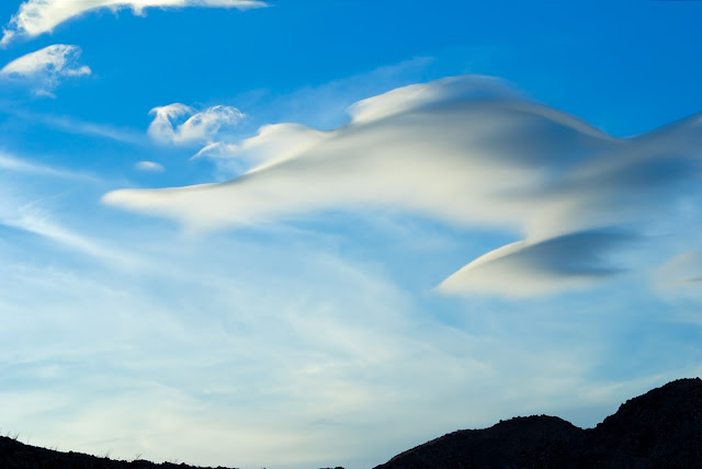
Cool clouds
Panorama of Indian Valley North, False Sombrero is on the far left and my red truck is a small dot in the lower left

--
<em>edited by dsefcik on 3/10/2011</em> |
3/10/2011
Topic:
Indian Valley North / Inner Psture
dsefcikAdministrator
|
And carry it around with you...
surfponto wrote:
Those are awesome pictures.
Makes me want to upgrade to a digital SLR. Then again I would have to learn how to use it.
 |
3/12/2011
Topic:
Peak 6582 redux
dsefcikAdministrator
|
Thanks Stewart, I was actually gonna respond today as I was finally able to get confirmation from my friend what days he can go and it turns out only Sat/Sun. He needs to be back Sunday evening so I think we are just gonna do single over night trip in Indian Valley. If anything changes I will let you know. Be sure to post a trip report when you get back, I am sure it will be a great trip!
Daren |
3/15/2011
Topic:
California Bighorn Sheep in Canada
dsefcikAdministrator
|
So apparently the California Bighorn sheep habitat extends from British Columbia down to California and over to North Dakota (per Wikipedia). This wildlife photographer has a great collection of photos of California Bighorn near Kamloops Lake in British Columbia:
http://petersulzle.zenfolio.com/p937732466
Amazing photos...
Sorry not Borrego specific but interesting and somewhat related. |
3/18/2011
Topic:
Peak 6582 redux
dsefcikAdministrator
|
We are shooting for the north fork...but plans do change... |
3/23/2011
Topic:
Indian Valley / Inner Pasture Macro Tour
dsefcikAdministrator
|
My friend Scotty "C" and I just got back from a macro tour of Indian Valley and Inner Pasture. The wildflowers are blooming in Anza Borrego right now but you need to get down on your hands and knees to see them. There is so much life at the macro level in the desert. Scott and I started at the north fork of Indian Valley and headed up to False Sombrero. This is a very short distance of about 1 mile but it took us almost 2 hours, mostly due to my constant stopping to take pictures of all the different micro flowers blooming everywhere. We continued over the ridge and down into Inner Pasture where we found a spring, illegal traffic clothing, Indian Morteros, Indian Rock Carvings and even some Indian Pictographs. I even managed to lose Scott's $300 GPS and my camera screen cover along the way.
Check out all of our photos from the trip http://sefcik.smugmug.com/Photography/Anza-Borrego-Desert-State-Park/Indian-Valley-Inner-Pasture-03/16296710_uSEeV
Here are a few pics, most of the flowers I took pictures of were very small, just a few inches above the soil. Insects were everywhere and the colors on the Chuparosa and Ocotillo were crazy bright.


-- |
3/23/2011
Topic:
Indian Valley / Inner Pasture Macro Tour
dsefcikAdministrator
|
Thanks for the comments, I am really enjoying using the camera and need to thank Andy for pushing me to finally get a good camera. I really do need to find a better way to carry it around though, maybe one of those chest thingies...
@David, no gps tracks..note the comment "I even managed to lose Scott's $300 GPS and my camera screen cover along the way." It was a loop hike around false sombrero and back into indian valley via a low saddle east of the end of the valley. Most of the flowers really were small, most were only a few inches above the ground and only an inch or so big (some smaller) and it was hard to get clean pics with the wind blowing them around.
@Bob, I know you mentioned wanting to go out there, I have the next couple of weeks off (sorta) for spring break so let me know. |
3/24/2011
Topic:
Indian Valley / Inner Pasture Macro Tour
dsefcikAdministrator
|
surfponto wrote:
Let's say tentatively next week Wednesday possibly.
Sounds good..
Here is a pic Scott sent me, this is climbing up False Sombrero..it was kinda steep...it also shows the size of most of the flowers I took pictures of.
 |
3/24/2011
Topic:
Henderson Canyon, Palm Mesa, Borrego Palm Canyon
dsefcikAdministrator
|
That looks like a great trip..I wish I could get away with carrying only 5 liters for that distance.
Do you have any trips from Borrego? |
3/24/2011
Topic:
Henderson Canyon, Palm Mesa, Borrego Palm Canyon
dsefcikAdministrator
|
Alexey wrote:
dsefcik wrote:
Do you have any trips from Borrego?
You mean Borrego Springs?
Actually, I have hiked almost every corner of the ABSP, but still have some unrealized trips and new ideas like:
Lorenzen's Peak (aka 6582)
Toro - Villager (Santa Rosa) Full Traverse,
a couple of new routes to Whale Peak (from June wash and through Bisnaga Wash)
Red Top Mountain (looks rugged)
etc.
I will share my best trips as soon as I prepare them for EveryTrail.
I have 6582 on my agenda and also Red Top (almost made it last weekend but time and itty bitty flowers distracted us). I hiked about 3/4 up Whale Peak thru Bisnaga Wash last summer..again another route on my list. Maybe over this Spring Break I will make a few of them.
-- |
3/24/2011
Topic:
Henderson Canyon, Palm Mesa, Borrego Palm Canyon
dsefcikAdministrator
|
This forum topic shows my whale peak route that I did about 3/4 of:
http://forums.anzaborrego.net/travel/anzaborregoprevious/forum/topic43-whale-peak-backpack-possibility.aspx
-- |
3/25/2011
Topic:
Indian Valley / Inner Pasture Macro Tour
dsefcikAdministrator
|
David, here is a rough sketch of where we went:

--
<em>edited by dsefcik on 3/26/2011</em> |
3/26/2011
Topic:
6582 redux
dsefcikAdministrator
|
Thanks for posting Stewart, I wondered how you would do with the weather being rainy and cold. The flowers were pretty crazy for us also hiking in Indian Valley, they were layered at different elevations climbing up False Sombrero. Can't wait to see some pictures of your trip! |
3/26/2011
Topic:
Indian Valley / Inner Pasture Macro Tour
dsefcikAdministrator
|
hikerdmb wrote:
Daren,
That's pretty much what I pictured when I look at GE from your description but I thought you went around the peak to the west. That berm going across the middle of the Inner Pasture looks very interesting from the GE view you posted. Is it real noticable when you are there? Is it just the edge of the wash or something else?
David
That berm was definitely an interesting landmark. Down at the valley level it just looked like a big soft sandy hill, it was only after you climbed back out could you see it was just a berm. This link is a panorama shot from False Sombrero and you can see it way down in the valley:
http://sefcik.smugmug.com/Photography/Panoramas/16201833_YA53r#1228992998_rfXrp-O-LB
<em>edited by dsefcik on 3/26/2011</em> |
4/2/2011
Topic:
6582 redux
dsefcikAdministrator
|
Those are awesome pictures Stewart! That was a great weekend for flower blooms but it got cold Sunday. I just went out Thursday to see the petroglyphs and it was 97 degrees, quite a difference in weather. That tree where your truck was parked is a popular spot, it has the only shade around...I took this photo of a small bird staying out of the heat

Thanks for sharing those pictures and the story with them, let us know when you are coming back out again!
Daren |
4/2/2011
Topic:
6582 redux
dsefcikAdministrator
|
The pics are great and your story with them make it greater!
I noted the other day while I walked out there a set of solo prints and then as I got near the boulders and the wash opened up there were a lot of prints. I am thinking the solo prints were from you and the mass of prints was from the group that visited that Saturday (as I noted in the other thread about this trip).
I saw a ton of the white lizards, did you?
Daren
<em>edited by dsefcik on 4/2/2011</em> |
4/2/2011
Topic:
Indian Valley and then some
dsefcikAdministrator
|
Probably not totally appropriate but after you left I drank a bunch of beers and couldn't find anything else to take a picture of.
Cholla Ball wounds up-close
 |
4/2/2011
Topic:
New Anza Borrego 2011 Wildflower season slideshow
dsefcikAdministrator
|
Those look great Bob and way to go with jquery....boo flash..boo.... |
4/2/2011
Topic:
Piepkorn slot
dsefcikAdministrator
|
Any updates on this? I wouldn't mind stopping by there and have a look at it. |
4/2/2011
Topic:
Indian Valley and then some
dsefcikAdministrator
|
I think took this one a couple of more beers after the cholla ball wounds one, I figured it was a great idea at the moment...
-----------------------------------------------------------------------------------------------------------------------------------------------
The side of my brand new truck after one year of desert driving. It really doesn't fit very well down jeep trails and the tree branches pretty much scratch the sides of the truck almost every time.
 |
4/2/2011
Topic:
Indian Valley and then some
dsefcikAdministrator
|
hikerdmb wrote:
That is an amazing camera!
OMG..I just looked at the original sized photo full screen...eeek...that's my leg!
Click this link for a full size, up,up close shot:
http://sefcik.smugmug.com/Photography/Anza-Borrego-Desert-State-Park/Indian-Clark-Blair-Valley-03/16442960_DPj8h#1237209566_2LCMM-O-LB |
4/2/2011
Topic:
6582 redux
dsefcikAdministrator
|
Hey Stewart, in 22.html, is Schad's route up thru the slot you see in the middle right of the photo? I think he mentions a flat sandy area to camp ahead of that section. |
4/3/2011
Topic:
6582 redux
dsefcikAdministrator
|
Wow Stewart, that is great map..thanks! I think you have me motivated to try soon before it gets too hot. I can see now the wash from your picture going around the west side of the peak. I am curious though why you would swing south at the dry fall and then follow the Schad route instead of maybe traversing more north around the fall and then straight up the ridge to the peak. Is the terrain too tough from that point to make more of a straight line to the ridge? |
4/3/2011
Topic:
Indian / Clark / Blair Valley
dsefcikAdministrator
|
Official trip report is on my website http://www.sefcik.com/2011/04/indian-clark-blair-valley-abdsp.html
Bob has a great trip report for the day he was out with me, read his first, he is far better at writing up trip reports than I am.
http://www.anzaborrego.net/Travel/AnzaBorrego/post/2011/04/02/Wildflowers-and-Pictographs-in-Southern-Anza-Borrego.aspx
--------------Copied from my website----------------------
Camped out for three nights last week in Indian Valley and Blair Valley. Bob from the Anza Borrego website wanted to check out some pictographs Scott and I found on a previous trip so I met him in Indian Valley for a second trip out to Inner Pasture where the pictographs are located. Along the way we spotted a Red Racer snake lounging in the sun and also many wildflowers blooming in the sandy washes and rocky ridges we climbed.
The next day I headed over to Clark Valley to finally see the petroglyphs located near the dry lake bed. Temperatures that day reached 97 degrees on my truck dash, it was hot and I ended up drinking close to 120 ounces of water for a 4 mile hike. I camped the last night in Blair Valley where I knew it would be cooler and it was 87 degrees when I arrived near 5pm. I ended up camping at the Pictograph trailhead and in the morning hiked down to see the pictographs and also Smuggler Canyon. These pictographs are well documented by all of the Anza Borrego Visitor information pamphlets and are actually pretty cool to go see. The road is a 5 mile hard packed dirt road passable by almost any vehicle in good weather. In fact the only people I saw showed up in a Honda Fit. They stayed briefly and then I had the whole area to myself until I left the next morning.
Total Mylar balloon count for 3 days of hiking....15
You can see more pictures of Indian Valley, Clark Valley and Blair Valley here http://www.darensefcik.com/Photography/Anza-Borrego-Desert-State-Park/Indian-Clark-Blair-Valley-03/16442960_DPj8h
Here are a few of my favorite pictures from the trip.
Red Racer snake

Fishhook cactus, now I see why they are named this..8-)

Desert Beetle covered in pollen

Turkey Vulture in Indian Valley

Desert Iguana in Clark Valley

Side-Blotched Lizard in Blair Valley

White-crowned Sparrow in Clark Valley

Here links to some very large panorama images of Clark Valley and Smuggler Canyon (warning, they are very large to download, 4mb & 9mb)
Clark Valley: http://www.darensefcik.com/Photography/Panoramas/clarkvalleypanorama/1237667571_t56Ud-O.jpg
Smuggler Canyon: http://www.darensefcik.com/Photography/Panoramas/smugglercanyonpanorama/1237668078_bNyuH-O.jpg
--
<em>edited by dsefcik on 4/3/2011</em> |
4/4/2011
Topic:
Indian / Clark / Blair Valley
dsefcikAdministrator
|
surfponto wrote:
How are you doing those panoramas? Do you have to stitch the images together?
Basically you take the pictures from left to right with a 50% overlap. Then you stitch them together with software. I use a program called Hugin, it works awesome. You can download it here: http://hugin.sourceforge.net/ |
4/4/2011
Topic:
Indian / Clark / Blair Valley
dsefcikAdministrator
|
surfponto wrote:
Those wildlife pictures look like they are out of National Geographic
Think I am going to put a DSLR on my wish list.
Great job
Bob
Thanks Bob...since nobody from NatGeo has called me yet I guess I will keep my regular day job and save up for some really good lenses.... |
4/5/2011
Topic:
Indian / Clark / Blair Valley
dsefcikAdministrator
|
Thanks Bob, Stewart..I appreciate the comments. I really enjoying taking the pictures, I think I am getting better at figuring out what buttons to press on the camera now.
I suppose I should also explain the mylar balloon comment for those who have not hiked with me. I always say "You can't hike in the desert without finding a mylar balloon" and anyone who has hiked with me will tell you that is true (usually) (at least with me). This particular trip out was probably the worst yet to date, a total of fifteen mylar balloons were found and that was not counting the ones I saw on the side of the road driving 70mph on the S2. I started picking them up and carrying them back with me a couple of months ago.

--
 |
4/10/2011
Topic:
2011 Wildflowers
dsefcikAdministrator
|
Here are some flower pics I have from this year, some may be from other areas of San Diego also but 99% are from Borrego.
http://www.darensefcik.com/Photography/Wildflowers/Wildflowers-2011/16543138_LSXQa |
4/13/2011
Topic:
Sacatone Overlook to Carrizo Gorge
dsefcikAdministrator
|
Another great trip down into the gorge.
Read the official trip report on my blog http://www.sefcik.com/2011/04/sacatone-overlook-carrizo-gorge.html
and more pictures here http://www.darensefcik.com/Photography/Anza-Borrego-Desert-State-Park
--
Scotty "C" and I headed out to Carrizo Gorge for our now annual Sacatone Overlook / Carrizo Gorge hike.
You can read about our trip last year here http://www.sefcik.com/2010/04/sacatone-overlook-to-goat-canyon-hike.html
This year we decided to go south in the bottom of Carrizo Gorge and see if we could find any remains of the old train encampment. The weather this year was much nicer than last year but the terrain and amount of elevation gain/loss still makes this a pretty difficult hike thru some of the least visited and remote areas of Anza Borrego. When hiking in this area of the park we usually do not even see any signs of illegal crossing routes, no dumped backpacks or discarded tuna cans. Scott and I both agree that if the illegals can make it thru this part of the backcountry than they probably have earned a spot here.
April brings Spring weather and also many wildflowers and snakes. We saw four snakes this trip but no rattlesnakes. Wildflowers and especially the cactus blooms seem more abundant in this area of the park. We covered about 9.5 miles total and about 5,000' of elevation gain/loss in about 9 hours. We made really good time compared to last year, mostly due to Scott's recent intense Jillian Michaels regiment...way to go Scott!!
Here a few pictures from the trip
GPS track of the route

Scott and I before we head down Cry Baby Hill

A metate and some pottery and other stone tool fragments

-

Scott asking if that is the way to the "trail"

A Gopher snake Scott almost stepped on, it was hard to see thru all the brush and branches

Balance Rock, we use this as a navigation marker

Yucca Bloom

This picture shows the canyon and train I hiked to a few months back. You can read that report here http://www.sefcik.com/2011/02/carrizo-gorge-old-railway-train-parts.html

A desert beetle in a cactus bloom

Down in Carrizo Gorge looking south

The largest looking remains of the old train camp

A Horned Toad Lizard hiding in a Cholla Cactus

All of the pictures from the trip can be seen here http://www.darensefcik.com/Photography/Anza-Borrego-Desert-State-Park
Daren
edited by dsefcik on 4/14/2011
<em>edited by dsefcik on 4/14/2011</em> |
4/13/2011
Topic:
Sacatone Overlook to Carrizo Gorge
dsefcikAdministrator
|
Mr moderator, I cannot get the url links to post correctly for my picture gallery, can you explain how to get around having the forum break it apart and add those other url parameters?
thanks! |
4/14/2011
Topic:
Sacatone Overlook to Carrizo Gorge
dsefcikAdministrator
|
I always forget to post the panorama shots...here are two from the trip
You can always see the full size images here
http://www.darensefcik.com/Photography/Panoramas/16201833_YA53r
This is the carrizo gorge tratin track area (click image to see larger size)

This is a huge chunk of the west side of the gorge that has sunk in maybe 20-30', you cann see better in google earth (click image to see larger size)

-
<em>edited by dsefcik on 4/15/2011</em> |
4/14/2011
Topic:
Sacatone Overlook to Carrizo Gorge
dsefcikAdministrator
|
hikerdmb wrote:
Daren,
Another great trip for you! That sunken hillside is very cool. Did you cross that? I was wondering if it was something fairly recent or not. Thanks for sharing.
David
We did not cross it, we were north of it. Here is a google earth shot from the train track side and you can see our route in red to the right. This imagery is dated 2/29/2008

I originally saw this mass on another website, he has a similar photo. He wrote a great TR about his mountain bike trip down the tracks, it is here:
http://www.billcaid.com/2010/CarrizoGorge20100103/CarrizoGorge20100103.htm
You should check out his home page, you might like his new 4x4 http://www.billcaid.com
--
edited by dsefcik on 4/14/2011
<em>edited by dsefcik on 4/14/2011</em> |
4/17/2011
Topic:
Carrizo Gorge Railway
dsefcikAdministrator
|
That's pretty cool...history in general is amazing, we all seem to forget how things came to be.
I have been down in the gorge (south of the trestle) 3 times now and it really is like a place forgotten by time, I don't even see signs of illegals (although it is up on the tracks). It is very difficult to navigate though, there is just so much catclaw and cholla it keeps travel to about 1/2 mph at best. We searched for a 1/2 hour this last trip just trying to find a place to cross the water.
I know that one section of train I visited a couple of months ago has been there for at least 1 year, I suspect the railway was functioning at some point but after the Easter quakes last year I know several tunnels have collapsed again. We saw a Bobcat last year out there clearing debris from the trestle.
Thanks for posting Stewart, any other interesting bits from the book would be great to read. All I can say from my time down in the gorge is it is very peaceful, you really don't want to leave. It is really just a different experience then other more visited areas of the park are. We actually found morteros and pottery sherds deep into the gorge, very strange places we thought. |
4/18/2011
Topic:
Carrizo Gorge Railway
dsefcikAdministrator
|
stewart wrote:
I think the Mexican line was still in service when this book was writ, 1988.
I don't have the full picture on this computer but my avatar on this forum was actually taken while riding on the train that runs from the old railway station out near Campo. It was taken probably back around 2001, I went with my kids and we did the tourist train ride. Is that same tracks do you know? I really don't remember it much now, maybe I need to go back and revisit. |
4/18/2011
Topic:
Carrizo Gorge Railway
dsefcikAdministrator
|
Here is the pic from the campo train ride with kids, we are sitting in the railway car that has no windows, just steel bars. You can see where I cropped out my avatar from. The other is just a train at the station. These photos are dated 4/2002.

 |
4/19/2011
Topic:
Carrizo Gorge Railway
dsefcikAdministrator
|
Guess they just had a big party also
http://www.eastcountymagazine.org/node/5958 |
4/20/2011
Topic:
Do tent campsites have firepits?
dsefcikAdministrator
|
You can always call the park headquarters just to make sure, the number is (760)767-5311 |
4/27/2011
Topic:
Galleta Meadows Sky Art Sculptures
dsefcikAdministrator
|
I have updated my Sky Art photo gallery with more photos and better quality images. If you do not know what the Sky Art sculptures are you should definitely check out the Galleta Meadows website and have a look at some of the pictures on my website. If you are new to the Anza Borrego Desert and are planning a visit, please be sure to set aside a few hours to explore the sculptures and have fun, kids love them! I believe there is a new sculpture being built now, I will be heading out this weekend to see how it is progressing.
Galleta meadows Website http://www.galletameadows.com/
My Photo Collection http://www.darensefcik.com/Photography/Anza-Borrego-Desert-State-Park/Sky-Art/16733252_WcCZts
A few random pictures from my collection

--

--

--

--

--

--

--

--

<em>edited by dsefcik on 4/27/2011</em> |
4/27/2011
Topic:
Galleta Meadows Sky Art Sculptures
dsefcikAdministrator
|
Thanks David..I am slowly getting the hang of using the camera and having a lot of fun. I do mostly use the manual settings, they seem to give me more flexibility in determining how the photo will look. I heard Ricardo is building a new sculpture that will cross the road and is building it now. I am going out this weekend to check it out, I will post any updates.
Daren |
4/28/2011
Topic:
Big Three Shootout in Anza Borrego
dsefcikAdministrator
|
Interesting..my Dodge is the same model but has a long bed. I can get 20/21 mpg for all freeway driving and about 16mpg regular day-to-day running around. It is totally stock. It does well off road also except for the crappy stock suspension, that needs to change. My EB works fine, in fact I love it..sometimes I will speed up and let off the pedal just to hear it go bummm...bummmm...bummmmm
Thanks for sharing Bob! |
5/2/2011
Topic:
Bighorn Sheep Sighting
dsefcikAdministrator
|
Me and Zeek were out panning for some nuggets near Henderson canyon this last weekend when I noticed something off in the distance.

Zeek is a pretty good guy but he wasn't having much luck with the gold on this trip

I zoomed my camera all the way in to see what the two figures off in the distance were

I still had one more zoom level to use

Turned out there was a whole family of Bighorns out that morning

I think Spring may have been in the air as there seemed to be two males fighting over the cute one in the middle

This poor little feller lost his mommy

But all was good in the end

Well, Zeek and I had to get back to work before the boss man found us horsing around

It's a long day out in the fields

See more Sky Art photos on my website http://www.darensefcik.com/Photography/Anza-Borrego-Desert-State-Park/Sky-Art/16733252_WcCZts
http://www.sefcik.com/2011/05/bighorn-sheep-sighting-in-anza-borrego.html
Daren
<em>edited by dsefcik on 5/2/2011</em> |
5/2/2011
Topic:
Bighorn Sheep Sighting
dsefcikAdministrator
|
Can't say I was ever much good with them spelling words and all...heck, now you're gonna tell me it's Pete and not Peet..dang..
Yeah, this last weekend was picture perfect, low 70's, slight breeze and sunny. Indian Valley was gorgeous! The park service also finally put up steel posts to keep campers out of the wash near Torote Canyon, people were ignoring the rocks and just moving them. They also cleaned up the rock fire ring at the very end of the road. |
5/2/2011
Topic:
Hot Springs Mountain on Los Coyotes reservation
dsefcikAdministrator
|
That looks pretty cool, since it is on the reservation do you need to get approval or is it public access? |
5/4/2011
Topic:
Yaqui Pass 360 Degree Panorama View
dsefcikAdministrator
|
On my way back from photographing the Sky Art Sculptures I stopped to hike around Yaqui Pass and the surrounding ridge line area. There are some very good views from that area. I photographed a 360 degree view that includes views of Borrego Springs, Mine Wash, Sunset Mtn, Pinyon Wash, Pinyon Ridge,Granite Mtn, Grapevine Mtns, San Yisidro Mtns, Toro Peak, Coyote Mtns and Villager/Rabbit Peak and probably more.
You can see a larger size here 
Or you can see the original full size (9.6MB) here
Daren |
5/23/2011
Topic:
Great Horned Owls
dsefcikAdministrator
|
On a recent trip to Anza Borrego Desert State Park with my son we spotted a large moving mass a few hundred feet up the rocks of a hillside. I pulled over and looked a little harder, turned out to be a Great Horned Owl. A male I believe. He was pretty far away and my 300mm lens just couldn't pull him in very close. As I was taking pictures of him my son saw two more owls, these were whiter in color and I believe the young owlets. They seemed to stay mostly hidden, only poking their heads out occasionally. The male flew off to a nearby crevice in the rocks where I believe the nest to have been and the young owlets finally emerged from hiding for a couple of pictures. After a few shots we left them alone and moved on.
http://www.sefcik.com/2011/05/great-horned-owls-abdsp.html

--

--

--

<em>edited by dsefcik on 5/23/2011</em> |
5/24/2011
Topic:
Little Blair Valley And My New Lens
dsefcikAdministrator
|
OK....so I admit it..I bought a new lens for my camera...guess what kind it is....
(Misc photos from Little Blair Valley 5-21-2011)
http://www.darensefcik.com/Photography/Anza-Borrego-Desert-State-Park/Blair-Valley-05-21-2011/17203543_T47WNX
Side of my truck with my son and the camp area in the reflection

Pottery Sherd at the Morteros Village Site

Really deep mortero

One of two caves we found

Pictograph Trail Picto Boulder

Yoni near the Morteros Village site

Cactus Garden at the Morteros Village site

Phalic Rock #1

Phalic Rock #2

Daren
<em>edited by dsefcik on 5/25/2011</em> |
5/25/2011
Topic:
Little Blair Valley And My New Lens
dsefcikAdministrator
|
hikerdmb wrote:
Daren,
but after it looked like it would be hot went to the mountains instead.
David
The only thing you missed was a billion bugs trying to attack you....and some heat.... |
5/25/2011
Topic:
Little Blair Valley And My New Lens
dsefcikAdministrator
|
Because of the overwhelming response to this thread I decided I should post a few more pictures from the trip to pacify the readers.
Birds nest buried in a Cholla Cactus. This photo does not do justice to the insane position of this nest. It is DEEP inside a cactus, far away from any predators reach.

Cupules Petroglyphs at the Morteros Village site

Cave #2 we found..this one was very large and had an old fire ring with some Pinyon Pine branches still around

Morteros Village site boulder with Cupules Petroglyph's

Pretty cool morteros boulders

Split Rock at the Morteros Village site

Pictograph Trail Pictograph

Pictograph Trail Pictograph with color enhancement to show off the yellow pigment

--
edited by dsefcik on 5/25/2011
<em>edited by dsefcik on 5/25/2011</em> |
5/26/2011
Topic:
Little Blair Valley And My New Lens
dsefcikAdministrator
|
surfponto wrote:
When you say hot, how hot do you mean?
I want to do another trip out soon
It was in the 80's but the bugs were really,really bad. The forecast for this weekend is high 90's. |
6/3/2011
Topic:
Snakes This Season
dsefcikAdministrator
|
Trying to throw some blood into this place...here are some pics of snakes I have seen hiking this season so far. Some are in Anza Borrego.
http://www.sefcik.com/2011/05/snakes-are-wildlife-too.html
Rattlesnake on Cowles Mtn

--

--

--

Red Racer Snake in Indian Valley

--

Gopher Snake in Carrizo Gorge
Gopher Snake in the San Dieguito River Valley

--

Daren
<em>edited by dsefcik on 6/3/2011</em> |
6/6/2011
Topic:
Snakes This Season
dsefcikAdministrator
|
No worries, I'll have some stuff for you over the next few months..my season is just starting!
surfponto wrote:
ON another note
The forum seems to have died a bit. This happened last year too about this time.
What noone likes to go out to the Desert in June- August?
What is up with that? |
6/7/2011
Topic:
Snakes This Season
dsefcikAdministrator
|
Thanks Stewart...I have been using a Sony A300 with mostly the kit lens 70-300mm it came with. Works good as long as I can get close enough.
The desert is a great place to start going out to now as it is a whole new place to explore once triple digits begin.
stewart wrote:
Wow, Daren, what are you using for a camera and lens? The detail in your photos is like looking at the real thing.
Really woke me up too...I guess the desert is pretty shut down now, except for hard core desert rats? Our wildflowers are going nuts up here...we keep having mild storms pass thru that keep everything wet and the long days are making the plants grow like spring was starting all over again. |
6/7/2011
Topic:
Snakes This Season
dsefcikAdministrator
|
When it hits 110+ even the bugs and snakes go into hiding during the day. Rabbits and birds are still out though. I think the snakes prefer 80-90'ish temps but will croak if out in super extreme heat. At night they will come out, so do the mice, scorpions and tarantulas.
stewart wrote:
Hmmm, you're one tough hombre. I can't take that heat. But June is certainly a different season from all the rest. All the things that depend on the sun's energy are out, like snakes, and bugs, as you know. Enjoy! And thanks for taking the time to post photos--it's a thrill to see 'em. |
6/10/2011
Topic:
Peak 6582
dsefcikAdministrator
|
Hi DHeuschele, I have not done this hike yet, it is still on my list. If you are interested in going out there let me know and maybe we can find a date to head out. It may be too late this season as triple digit temps are already starting.
It seems the news about Jerry is starting to spread, it is very,very sad. I don't think I would have ever started hiking some of the areas in San Diego that I do now if it was not for his books I started reading some 25 years ago.
Daren |
6/13/2011
Topic:
Ocotillo Express Wind Energy Project
dsefcikAdministrator
|
Looks like they are starting. When I was driving home this last Sunday it was 99 degrees outside and there was a security guard onsite guarding the property. He was in a puny little hut and came out to see what I was doing just as I was starting to drive away.

<em>edited by dsefcik on 6/13/2011</em> |