2/26/2020
Topic:
Thimble from Cherry Canyon
tekewin
|
dsefcik wrote:
I think that is the way Gary and I went once but we never summited the last rock scramble...nice work!
Thanks! For me, Thimble is one of the icons in AB. It is one of the very few mountains I've climbed more than once. Looking forward to number 3. |
2/26/2020
Topic:
Can anyone ID this location?
tekewin
|
Not sure, but I would guess that is Split Mountain in the background with the Vallecito Mountains continuing to the right. |
2/26/2020
Topic:
Martinez Mtn. Snow
tekewin
|
Is the photo from the east or west? I remember the main trail being from the east and very, very, long. Haven't been out there yet but would like to. |
3/22/2020
Topic:
Solstice Cave and Goat Canyon
tekewin
|
Nice photos. It's a magical place. I also had a hard time finding it even with a pretty good description of where to look. I only went a little past it before spotting it below. I felt an unusual sense of calm in the cave. |
3/22/2020
Topic:
Three Saturdays in Canebrake
tekewin
|
Very nice! Those old soda pull tops could be made into a launcher. You separate the flat part of the tab from the ring, then load the ring onto the wide side of tab using the notch on either side , then fire! |
3/22/2020
Topic:
Granite Mountain Overnight
tekewin
|
Great report, thanks. It definitely doesn't sound fun to be camping in the cold during a storm. Winds in AB are the harshest I've experienced. Granite is a hard mountain, worthy of the name. |
4/11/2020
Topic:
GPS Collar Retrieval Near Rabbit
tekewin
|
Amazing trip! That trip had everything in it and a cool way to get to Rabbit.
I am curious about that cement cylinder with the benchmark in it. Was it stamped with a name? Seems like an odd place.
I am itching to get back out there in some remote place, but the park is officially closed. From what I read, even dirt roads and washes are closed. Gonna hunt online for a national park that is still open. Going crazy sitting home. (edit to check notification box)
edited by tekewin on 4/11/2020 |
4/11/2020
Topic:
GPS Collar Retrieval Near Rabbit
tekewin
|
Thanks! yeah, the metal stamp version of white out, haha!
I was just checking out BLM land in caltopo.com. I think I am gonna try to do something off McCain Valley Road. |
4/16/2020
Topic:
In Search of PAH
tekewin
|
Great sheep shots. It's messed up that the topo map has PAH at the wrong location. Probably not visited/used often. |
4/16/2020
Topic:
My Buck Knife
tekewin
|
I was wondering about a sheath from the first pics, then I thought cool, sheath, then I saw blood. Uh oh. Looked like that could be bad, hope it wasn't. |
4/16/2020
Topic:
Pepperwood and Bow Willow
tekewin
|
Drove the end of McCain Valley Road last Sunday for a BLM hike. Well, almost to the end of the road. The last half mile was badly rutted from rain so I stopped at the last windmills. No cars around, no people. It had rained on me the entire drive until the end when I saw patches of blue sky.
A single track continues north from the end of the road. It's mostly gently rolling land and half open desert. Eventually, I hit an old dirt road heading toward Pepperwood, which sits just above Canebrake.

Pepperwood, the high point is the middle bump. Red Top rising behind.
Pretty good scramble to the top, but only a couple of hundred feet. Thought I had found a register on top, but it turned out to be some kind of solar powered radio relay or something. Views were so nice into Canebrake and toward the Sawtooth Mountains.

Radio?


The tippy tops of False Sombrero and Sombrero
It was a few miles back on the road to get to the base of unofficial Bow Willow Peak. There was already the start of a some nice yellow blooms around the base. There is a line of giant boulders making up the summit. The highest boulders were class 5 and beyond reach without a rope. No register or marks found on either one. It felt great to get outside. Too bad so much public land is closed right now.
Bow Willow ahead


Looking back toward Pepperwood

Baby gopher snake, maybe 18 inches long
[edited for formatting]
edited by tekewin on 4/16/2020 |
4/16/2020
Topic:
Pepperwood and Bow Willow
tekewin
|
Rocko1 wrote:
Very nice! Isn't the route into Canebreak from there a heavily traveled immigrant route? Maybe the radio is used by them?
I'd probably guess border patrol over immigrants based on resources, but who knows. I didn't take the rocks off to open it or get serial numbers. Should have. |
4/17/2020
Topic:
Pepperwood and Bow Willow
tekewin
|
Brian wrote:
Great trip report. I've done hikes leaving from Cottonwood campground, but have never driven the road beyond there. Always meant to some day. It's on my very long list of places I want to explore some day.
There's maybe a mile of road after Cottonwood. I chickened out when facing the deep ruts, probably could have driven them but was happy to hike a little extra. I'm thinking about looking around Mojave until AB reopens. Or going further east on I-8. I can do those trips with one stop for self serve gas and no interactions. |
4/17/2020
Topic:
Pepperwood and Bow Willow
tekewin
|
dsefcik wrote:
I love that area, Tom and I have been at the base of Pepperwood like a million times but never scrambled up. You should have looked closer at that radio thing to see what it was, most likely BP but not sure what for but would not doubt crossers at all. We have run into folks on the path out there at least 3 times now. That rutted section only lasts a few hundred feet, usually you can straddle it and get past if you have some ground clearance.
It is a cool area. I had only started around there once before heading to Al Holden Peak. I have plenty of clearance (4Runner) but didn't know the road got better so backed down. |
4/17/2020
Topic:
Pepperwood and Bow Willow
tekewin
|
dsefcik wrote:
I think parts of CNF are open as well as wilderness areas of BLM, all within reach of ABDSP areas.
Thanks, I'll do some more research. Caltopo has nice overlays for BLM. I probably shouldn't complain about closed parks. First world problem. |
4/17/2020
Topic:
Pepperwood and Bow Willow
tekewin
|
Rocko1,
Can you point me toward Domelands? Not sure where that is. |
4/17/2020
Topic:
Pepperwood and Bow Willow
tekewin
|
Tommy 750,
Thanks! Will take a look. |
4/23/2020
Topic:
Domeland/Wind Caves
tekewin
|
Excellent! Love the flowers. I hope to visit some day. |
4/23/2020
Topic:
Toloache
tekewin
|
I've seen dozens of those plants on the Coal Canyon trail off the 91 at Green River. I knew they were poisonous, but not that they were used for so many pharmaceuticals. Cool plants. |
4/23/2020
Topic:
Photography
tekewin
|
Bug's Life edition. Cool. Nice looking spider. |
4/27/2020
Topic:
Pepperwood and Bow Willow
tekewin
|
rockhopper wrote:
Nice clear desert views. Your expedition was perfectly timed. Thanks for sharing.
Just lucky on timing.  |
4/27/2020
Topic:
Photography
tekewin
|
Stunning hummingbirds! Whenever I run into them, their wings sound like large bugs. |
5/12/2020
Topic:
Cleveland NF
tekewin
|
Great! The view from Garnet is one of my favorites in the park. Can't wait until the whole park is officially re-opened. |
5/20/2020
Topic:
Park Closed?
tekewin
|
Anybody heard any rumors about re-opening? Park web site was last updated May 1, but still says everything closed including dirt roads. |
6/3/2020
Topic:
Cuyamaca SP
tekewin
|
Thanks for the photos and update.
Can't believe AB is still closed. Most of ANF is open, OC trails and parks open. San Diego county had +2 cases today, almost nothing. Hair salons are open in the OC, but the 600,000 acres in AB is just too tight to be safe. I will call them tomorrow if I have time to find out why.
edited by tekewin on 6/3/2020 |
6/4/2020
Topic:
Cuyamaca SP
tekewin
|
Called the state park today and they said no idea on re-opening AB, but it would be posted on the web site the day the decision was made. Not very helpful. |
6/4/2020
Topic:
Cuyamaca SP
tekewin
|
Great news! I'll be checking the web site tomorrow. |
7/8/2020
Topic:
Diablo BM
tekewin
|
That's a fun hike. Great photos and stuff from the register. I remember lots of agave when you first leave the road. |
7/29/2020
Topic:
Owens Valley
tekewin
|
Thanks for report! It took me a few minutes to figure out that tent set up. Clever.
You got some close up sheep, always a treat. The White Mountains are still on my to-do list. I've heard the road is really long and rough. |
7/29/2020
Topic:
Diablo BM
tekewin
|
Rocko1 wrote:
There is a phenomenal amount of Cholla cactus. I have never been 'bit' by some many in any trip. I think at least 20 times I got jumped.
edited by Rocko1 on 7/10/2020
Yes! A couple of dense cholla gardens. As soon as I stop concentrating on it, it gets me...

edited by tekewin on 7/29/2020 |
7/29/2020
Topic:
Diablo BM
tekewin
|
Haha, yup. Tweezers are a necessity. It's not just the cactus itself, but the landmines that I often kick into my calf. But you win with 75+ needles. Ouch. |
9/19/2020
Topic:
Valley of the Moon to East Davies Valley
tekewin
|
Great report and photos! I haven't been around the forum much since COVID, but I missed this report back from back in January. I'll add VOM to my hike list based on your great photos.
With most forest areas closed right now, I'm tempted to head back to the desert before temps become comfortable. Might not be a good idea. |
9/27/2020
Topic:
Lookout Knob
tekewin
|
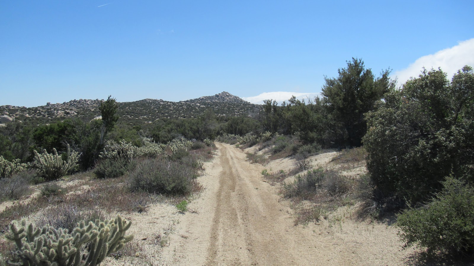
Back in January, I made an attempt on Lookout Knob, a 100' rock spire in Hellhole Flat. I didn't find a way up then so went back for another try.
While there is no easy way to Hellhole Flat, I took Buford's advice to approach from the west. I started on Cherry Canyon Road and went over the saddle south of the Thimble. From there, it was downhill cross country to the base of Lookout Knob. The terrain was not too brushy, but was rippled with a few dry stream crossings. I brought some climbing gear, but found a much better scramble route this time from the northwest and ended up not needing it. There were a couple of exposed class 3 moves and two ledge traverses to reach the top. I placed a register below the summit block in a plastic sandwich box. It was a really nice day, but did get warm on the way back which was mostly uphill. It was 55F in the morning, but about 90F when I got back. Felt great to get back in the desert. 9.3 miles, 7 hours, ~2850' gain. Full report.

Coming down from the saddle below the Thimble

Almost to the base of Lookout Knob

Entrance to northwest scramble route

This was the crux move with a ledge you can't see going left above it

Summit block

Placed a register below the summit block


Heading back


Got a little sloppy on the way back with some unnecessary ridge climbing |
9/30/2020
Topic:
Lookout Knob
tekewin
|
rockhopper wrote:
Nice trip report and photos. Ditto what Rocko1 said. The hardest moves and most fear is going down with no rope.
This one is not really that bad. No worse than the Thimble as long as you find the best route. The rock is better on the Thimble, though. |
9/30/2020
Topic:
Lookout Knob
tekewin
|
ziphius wrote:
Great trip report. I still need to explore the Thimble area.
Yes! It's an amazing area. I still have the Hob benchmark to climb near there and I want to spend half a day just exploring Hellhole Flat when it cools off a little. I'm psyched about winter and desert season. |
10/4/2020
Topic:
Lookout Knob
tekewin
|
Scooter wrote:
Does anyone know if Anza Borregos dirt roads are open ? Thinking of going up to Whale and takin Pinyon Mtn road. Thanks in advance Scooter
Yes, they are open. This is from the official web site updated September 20:
What is open now?
The following is open at this park:
- Backcountry Unpaved Roads
- Hell Hole Day-use Area: for day-use activities only from sunrise to sunset.
- Sunrise Trail Head Parking / Day-use Areas
- Camping (developed and primitive)
- Dispersed Backcountry Camping
- Coyote Canyon Above 3rd Crossing
- North Coyote Canyon / Turkey Track Access Gate
- Peg Leg Primitive Camping Area
- Culp Valley Primitive Camping Area
- Borrego Palm Canyon Full Hookup Campsites
- Borrego Palm Canyon Day-use (Borrego Palm Canyon Trail Map)
- Tamarisk Grove Campground Campgrounds
- Arroyo Salado Primitive Camp
- Blair Valley Primitive Camp
- Yaqui Pass Primitive Camp
- Yaqui Well Primitive Camp
- Bow Willow Primitive Camp
- Mt. Palm Springs Primitive Camp
- Fish Creek Primitive Camp
- Very limited parking is now available to the public.
|
11/2/2020
Topic:
Rockhouse Valley
tekewin
|
So much to explore out there. I've only been up the road a little to get to Coyote. Thanks for the report. |
11/2/2020
Topic:
Granite Mountain
tekewin
|
Wow, that wind was crazy! Granite is tough enough in perfect conditions. Well done. |
11/2/2020
Topic:
Photography
tekewin
|
Your stuff is pro quality. Love it!
You should start a new post next year so we don't have to scroll so much to get to the new stuff.
A red tail hawk attacked this eagle? Seems like it would be over matched. |
11/9/2020
Topic:
Election Week 2020 Hiding In The Desert
tekewin
|
Nice! I've never seen a coachwhip. Great photo quality.Love the sunset, too.
edited by tekewin on 11/9/2020 |
11/9/2020
Topic:
Arroyo Tapido mud caves
tekewin
|
Been on my list a while. I didn't have any specific beta, just drove out and looked around. I tried five or six promising starts but only two led to long tunnels/slots. I know there must be more I didn't find.

Cave #1:


Cave #2:


Heart of mud
Some video:
https://www.youtube.com/watch?v=HEQypprK8kE&feature=youtu.be |
11/13/2020
Topic:
Arroyo Tapido mud caves
tekewin
|
ziphius wrote:
Very cool! Never been there, but admittedly a little scared.
Haha, I was too, that's why I knew it was worth doing |
11/13/2020
Topic:
Arroyo Tapido mud caves
tekewin
|
Rocko1 wrote:
Very nice. Did those about 5 years ago. Found some cool routes that popped up a vertical shaft near the top of a hill. Could really get 'lost' out there is enough time is spent.
"top of a hill" is where the danger is. I got about 20' up a side branch of cave #2, then my footsteps sounded hollow. Immediately went back. |
11/14/2020
Topic:
Arroyo Tapido mud caves
tekewin
|
dsefcik wrote:
The mud caves are fun and need several trips out to really see most of everything. On busy weekends there are groups of people everywhere and you will see where all of the entrances are, many are so small and hidden they are hard to find even if you know where they are. In Schad's book he advises not to walk on top of the caves as they are subject to collapsing down. Tragically this happened back in 2012 to a young man named Guillermo Pino so folks should use caution when exploring the caves.
Thanks for the info and warning. That's a rough way to go. The signs there advise against exploring the caves, but clearly a lot of people do. |
11/17/2020
Topic:
Arroyo Tapido mud caves
tekewin
|
Buford wrote:
Nice. I like the idea of exploring the mud caves, but I don't think you'll ever find me in there. Too scared. I was in Arroyo Tapiado a couple days after a storm once and saw a couple/heard cave ins and slides happen in different sections of the wash over a couple hours. It was kind of eerie standing in the wash bottom when all of a sudden you hear small pebbles rolling down hill followed by a bigger thump sound. This happened more than once that day. People were still crawling around the caves as this was happening.
I talked with a SAR person about the guy that disappeared. His last known location was only feet from where he was found yet it took them weeks to find him from what I remember of the case.
Yeah, after a storm is the worst time to go. You want that mud to be hard and dry. I can easily see if someone fell through to a hollow cavern, they would be almost impossible to find. Another geological wonder in AB. |
11/23/2020
Topic:
Roost Benchmark
tekewin
|
Great trip! I did Roost because it was on the Sierra Club SD 100 list. I thought it was a great peak with a nice view of Granite. Wandering along that road, I remember getting the feeling that it was cougar country, but didn't see anything.
Re: marker elevations. I've rarely seen elevation stamped on most markers. Clearly, Roost is way off.
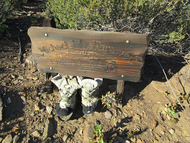
On the road down from Lucky 5, did you see the memorial boots for Michael John Farawell? Not sure if the memorial is still there.
 |
11/23/2020
Topic:
Photography
tekewin
|
More awesome photos. Holy crap, snake under the car tire. I need to stay alert for that. Is there a reason the other desert remains unnamed? |
12/7/2020
Topic:
Cactus Spring trail
tekewin
|
Cool report. All new to me. |
12/7/2020
Topic:
Whale Peak via Pictographs/Smugglers Canyon ?
tekewin
|
I've looked at the topo of those canyons on the south side wondering if anyone has ever explored them. The links show that most, if not all, have been explored by someone. |
12/15/2020
Topic:
Whale Peak Via Little Blair Valley North
tekewin
|
Thanks for awesome report! The canyon looks really fun. The video snips bring it to life. |
12/15/2020
Topic:
Whale Peak via Pictographs/Smugglers Canyon ?
tekewin
|
dsefcik wrote:
tekewin wrote:
I've looked at the topo of those canyons on the south side wondering if anyone has ever explored them. The links show that most, if not all, have been explored by someone. Which cyns? Bisnaga? It's all great areas to explore. I also did a trip once that went up and over Whale and went down to Split Rock, that was a tough trip down over big boulders.
Yes, Bisnaga and the 4 large canyons to the east. Sorry about the late reply, I was not set up to be notified, but now I am. |
1/4/2021
Topic:
Fish Benchmark and Eagle Benchmark
tekewin
|
I kicked off 2021 with a two summit loop in the Fish Creek Mountains just east of the Salton Sea. Eagle BM is also the high point in the Fish Creek Mountains. I drove to the end of Split Mountain Road, then east for 5 miles on a dirt road that parallels the Plaster City Narrow Gauge Railroad. The second mile of the road had some deeper sand and I used 4x4 but not sure it was needed. I parked along the tracks near my planned exit point and walked less than a mile to the ascent gully. The gully was full of large boulders and dry falls. The 1500' ascent was a mix of class 2/3, but with careful route finding, most was class 2. A second ascent gully was about 500', followed by 300' on the final ridge to reach Fish BM. On top, I found a benchmark, reference mark, and register placed in 1979 by Wes Shelberg. Fish is seldom visited. The prior entry in the register was from a year ago and was the only entry in 2020. The register was only half full since 1979.


Start of ascent gully


From the top of the first gully


Looking over at Eagle BM, about 40' higher than Fish
I dropped back onto the plateau and started down a long class 2 gully toward Eagle. I was dumped out about 700' below Eagle in a confluence of canyons. I aimed for the slope left of Eagle and slowly picked my way up. I heard voices and saw a couple of hikers on the ridge on their way to Eagle, a surprise since I didn't expect to see anyone the whole day. After fighting up to the saddle below Eagle, I was startled by an explosion above the summit. Some kind of loud fireworks had gone off above the summit, followed by a second explosion. In 15 minutes, I was on the summit with a party of six hikers and a dog. They were the vanguard of a larger group and set off the fireworks to let the others know they had reached the summit. I chatted with a guy named Alexis and discovered they were all local. I found no benchmark on Eagle, but the register also went back to 1979. The hikers settled north of the summit to wait for the rest of their group. I was only on Eagle long enough to sign the register since the day was short. I came down a steep, loose gully on the NW side of Eagle. Nothing was stable and I had to butt scoot most of it. I should have stayed on the ridge. Once on the lower plateau, I eventually found the remnants of an old miner's trail and was able to follow it on and off for the rest of the descent. Just under 8 hours round trip, 3300' gain, sore quads.


Looking back at Fish BM from Eagle

Some of the hikers on Eagle

Crappy, loose gully

Looking back at Eagle

Final descent

edited by tekewin on 1/4/2021 |
1/4/2021
Topic:
Fish Benchmark and Eagle Benchmark
tekewin
|
Rocko1 wrote:
Great report. Love the old register entries. That is some serious rock scrambling.
edited by Rocko1 on 1/4/2021
It was really fun going up to Fish. I was concerned there might be some really hard spots, but nothing really exposed or scary. |
1/4/2021
Topic:
Fish Benchmark and Eagle Benchmark
tekewin
|
Britain wrote:
Good job. Was up there from the southeast a few years back. Got within a 3/4 mile south of Fish. But fish wasn't what we were up there for. Thats some brutal stuff in there. Always had my eye on your route afterwards to tag fish.
Thanks, Fish was great! I thought the scrambling and gain was mostly over once I got to Fish, but was mistaken. Sort of a grind to Eagle, then a long 3.5 miles to get out. Legs are still complaining, but it hurts so good, haha. |
1/5/2021
Topic:
Fish Benchmark and Eagle Benchmark
tekewin
|
Britain wrote:
Had to get on GE to see the miner trail. Pretty cool down
The trail was in good shape up to the first plateau, then has some cairn markers, but kind of fades in and out all the way to the second plateau below Eagle. |
1/5/2021
Topic:
Fish Benchmark and Eagle Benchmark
tekewin
|
ziphius wrote:
Great trip! Too bad about the fireworks hikers. New Year's Day? I tend to avoid any New Year's hikes, *everyone* is out. But you at least had the expectation of remoteness!
It was actually 1/2 instead of New Year's Day, I should have been more clear. My first thought when I heard the fireworks go off was that someone was shooting up from the firing range below. Then I realized I was too far away even for a high powered rifle. |
1/7/2021
Topic:
Fish Benchmark and Eagle Benchmark
tekewin
|
Brian wrote:
Here's a trip report from a guy who did Eagle in November. I haven't done anything in that area but it's now on my (very long) todo list.
https://evanquarnstrom.com/2020/11/11/socal-desert-explorations-fish-creek-mountains/
Thanks, that was a cool report. From the register, it was clear that Eagle is far more popular than Fish. I am also surprised they found a bighorn skull. I don't remember seeing much evidence of sheep or deer out there. |
1/17/2021
Topic:
Rabbit Hemorrhagic Disease
tekewin
|
Thanks for the info. I've never heard of this. I'll keep a look out. Sounds like Rabbit ebola. |
2/10/2021
Topic:
Summit Registers
tekewin
|
I always sign if I find a register. I usually flip though to find rare autographs or people I know. I sometimes take photos of some of the pages. It often depends on how old and fragile the register is. If I find one that is really old and crumbly, I try not to disturb it. On Sierra Club peaks, I think they periodically collect them and archive the signatures. I find registers fun, but I think there are some purists who view them as litter. There was a streak of register shredding going on the San Gabriels a few years ago. One of my favorite registers was on Cobblestone Mountain in Los Padres which had a fancy custom aluminum box. I think the Sierra Club has only made a few of these and they are often on 14ers. Cool post!


 |
2/16/2021
Topic:
Martinez Canyon to Jack Miller cabin
tekewin
|
Thanks for the report and all the info. I want to get out to Martinez in the spring but I really need to study the roads and maps around there. |
2/17/2021
Topic:
Pyramid, Rosa Pt., Mile High Loop
tekewin
|
Great photos! Awesome trip. Tough stretch there between Pyramid and Rosa. |
2/17/2021
Topic:
Canebrake Valley and The Santa Rosas
tekewin
|
That was quite a hike up to the ridge! I'm not familiar the Cave story, will Google.
Very impressive painted pottery shard. I'm usually not looking for them when I'm out, but should be. I can't imagine how hard it must have been to live on this land. |
3/9/2021
Topic:
book recommendations?
tekewin
|
Just picked up Geology of Anza-Borrego. Good stuff, bringing back some Geology 1 memories. I have forgotten so much. What an interesting history. |
3/13/2021
Topic:
2021
tekewin
|
Awesome as always! Wow. |
3/13/2021
Topic:
Coyote Canyon
tekewin
|
Very nice report. You guys banked a lot of miles in 2 days. I've never seen a complete bighorn carcass. Freaky. |
3/13/2021
Topic:
Sheep Hole Mountains High Point
tekewin
|
Sheep Hole Mountains High Point (DPS #71) is a rough boulder scramble about 20 miles east of Twenty Nine Palms, north of highway 62. The high point has over 2000' of prominence. It averages about 10 visitors a year. I started from the shoulder of Amboy Road, paved all the way. I followed a gully route most of the way. The first half mile up the gully was mellow with small dry falls and easy bypasses. Higher up, the angle of the gully increased toward 45 degrees and boulders and falls got much larger. I drifted left above the gully and found a disjointed class 3 route over car-sized rocks. Although the forecast called for sunny skies, gray clouds had moved in and dropped sprinkles on me. A hard rain would have ended my bid for the summit.


Fresh scat, but I didn't see the perpetrators

Tough going

Stellar views started to open up as I got higher. The final half mile required navigation through bus-sized boulders. I moved in and out and under the boulders on a path of least resistance. I stumbled across some cairns leading around a pinnacle. I was moving very slowly at this point, losing steam, but the clouds had started to clear. Passing the pinnacle finally revealed the summit block. I'd read mixed things about the difficulty of the summit block. The obvious way up was via slab on the northwest side. It was class 3, but only the first 10' required pure friction. There were chunky holds the rest of the way. It was far more challenging to get to the summit area than climbing the block. The register was in an ammo box on top. On the way down, I found what looked like some airplane wreckage. It took nearly as long getting down as up. Tough little peak. 5.7 miles round trip, 2300' gain, 7 hours.

Summit


Going under some boulders on the way down

 |
3/14/2021
Topic:
Sheep Hole Mountains High Point
tekewin
|
rockhopper wrote:
Always had that one and Old Woman Mtn on my radar. Climbed the other "Granite Mtn" near Mitchel caverns near there. Similar granite boulders. Nice hike and great pics. Going down is a work out too! Hope you had good hiking poles.
Old Woman also on my radar. Long drive I think. Because there was so much hand and foot work, I left the poles behind. |
3/15/2021
Topic:
Sheep Hole Mountains High Point
tekewin
|
Rocko1 wrote:
Fantastic! How dicey was it coming off the peak boulder?
Rocko1, thanks! It wasn't hard to get down. It's solid rock, and there are big holds along the wide cracks. I was facing out most of the way down.
I had more trouble reaching the summit area and getting back to the gully. It was super fun, though. |
3/16/2021
Topic:
Sheep Hole Mountains High Point
tekewin
|
ziphius wrote:
Nice-going! I mean tough-going! A lot of work and a great view!
Thanks, Ziphius. Views were sweet. |
3/24/2021
Topic:
Rabbit/Village Peak Water Strategy
tekewin
|
rockhopper wrote:
I would do DHeuschle's plan. If you absolutely want to do a sun rise on top of Rabbit, do a headlamp start under the stars or moon light closer to the summit. I day hiked Rabbit from the Barton canyon route on the East side with a climbing buddy. One quart of water each in the winter.
A friend and I did the Barton route in May 2019. One quart for Rabbit? Wow. I think I drank 2 gallons, but we came down a different ridge below Villager. A ridiculous loop I don't recommend.
To OP: I vote with DHeuschele to camp at or below Villager. There are two bumps between Villager and Rabbit that add a few hundred feet of gain, but at that point, you are going to be tired and it feels like a lot more. Same with the final push to Rabbit.
It's awesome, though. Have fun! |
3/30/2021
Topic:
Chariot Mountain
tekewin
|
Everyone singing Chariot praises inspired me to visit on Sunday. The hike felt a lot like Roost, drop down, go up, drop down, go up. I took the firebreak both ways, pretty open. The small register is almost full, could use a new one the next time someone visits. Loved the views into Mason Valley and the weather was perfect. On the way back, I took a short side trip to Julian Ridge Benchmark. Surprised to find a register in cans there.


Chariot from Julian Ridge Benchmark |
4/6/2021
Topic:
Box canyon to nicholias loop
tekewin
|
I am really unfamiliar with the route you took. Could you please post a map of your route? Sounds like a big day. |
4/13/2021
Topic:
Martinez Mountain and Sheep Mountain
tekewin
|
First, the cougar. My friend Henry and did a loop down Cactus Spring Trail to Martinez, then cross country to Sheep Mountain. On the way back from Sheep, we walked up on a cougar resting in the shade of a small tree. The cougar was 15' away and bolted directly away from us at high speed. It was a surreal 2 second encounter. We checked the rear view frequently the rest of the way back, but don't think it followed us. First time meeting a cougar in the wild while hiking.
This was a very long hike. The Cactus Spring Trail was nicely maintained. Soft sand and wooden markers to keep you generally on track. Horsethief Creek had some water, but it wasn't flowing. We took the trail to the southeast ridge of Martinez, then followed a use trail with many cairns over 3 false summits. The summit plateau was filled with tall boulder piles and the high point was a 40' stack, requiring several solid class 3 moves. There was an ammo box on top with a register from 2003, only about 1/3 full. It's popular with peakbaggers being on both the Hundred Peaks List and Desert Peaks List. Awesome views of Rabbit, Toro, Asbestos, and Joshua Tree.


Rabbit from Martinez

Toro

We descended from Martinez down the main gully, full of boulders and run off. The rocks weren't too loose, but it was steep enough that it required attention. Then it was two miles cross country to Sheep Mountain. The high desert here is semi-open with cactus, junipers, cedars, and manzanita with enough space to weave in between. There were many ridges and bumps that prevented us from seeing Sheep until we were nearly there. GPS helped. Sheep was a walk up with a benchmark and standard HPS register. We followed a different ridge down and had more bumps to get over to get back to the trail. We were about a mile from the trail when we met the cougar. Once back on the trail, it was 4 miles and about 700' up to get back to the trailhead. In late afternoon, we found a small red diamond rattler (my favorite kind of rattler). Martinez was a spectacular mountain. Highly recommended!


Martinez from Sheep Mountain

Trying to get back to the trail

Red diamond, my favorite brand of rattlesnake |
4/13/2021
Topic:
Martinez Mountain and Sheep Mountain
tekewin
|
Brian wrote:
I really like this area but have never gone further than Cactus Spring.
Yeah, I really like it, too. Asbestos is the same kind of terrain. Large plants, small trees, but with space in between, and piles of stacked boulders. |
4/14/2021
Topic:
Martinez Mountain and Sheep Mountain
tekewin
|
rockhopper wrote:
Nice loop hike. Seeing the cougar was a plus. Matches your Icon. I have climbed up the the peak 2x via the normal route with the double false peaks. We had talked about climbing up one of those north face chutes. You went down them! Holly smokes! Did you move any boulders going down? Ditto on the snakes. They all seem to be rattlers'.
btw. Martinez and Cactus spring trail area is one of my favorite areas this time of year. I have never seen horse thief creek dry.
edited by rockhopper on 4/14/2021
The north face chute we went down is actually considered an optional route by the Sierra Club. The boulders are mostly stable and there is nothing technical. Not sure about the the other chutes. It gets a little tedious after 1000' or so, but it takes you directly below the summit.
It is such a cool transition zone between the desert and higher mountains. For convenience, I wish that creek was about half way to Martinez, ha. |
5/4/2021
Topic:
Rattler
tekewin
|
Speckled snakes are chameleons. I've seen them pink, red, sandy, and granite colored. Perfectly matched to surroundings.
@Brian, yeah, I don't get people blocking out nature sounds with music. A lot to head in the wild, including a warning that might save your life. |
5/27/2021
Topic:
Rabbit Peak Overnight
tekewin
|
I loved the first sunrise photo, but the ones on Rabbit were amazing! Some of the best I've ever seen.
Great job getting up there and back safely. Rabbit is mighty.
Dawns is still on my list, too, but it might be too hot already. |
5/30/2021
Topic:
Rabbit Peak Overnight
tekewin
|
Rocko1 wrote:
tekewin wrote:
I loved the first sunrise photo, but the ones on Rabbit were amazing! Some of the best I've ever seen.
Great job getting up there and back safely. Rabbit is mighty.
Dawns is still on my list, too, but it might be too hot already.
Thanks. Dawns is on my list as well. I think it will have to wait until cooler months. Also not something I would do solo.
Same. Not a good one to solo. |
6/17/2021
Topic:
Carrizo Gorge 3 Day Backpack
tekewin
|
Great report and photos!
I am a little surprised it wasn't too hot. I am guessing that gorge is one of the hottest places in the desert. |
6/17/2021
Topic:
Fire in Carrizo Gorge
tekewin
|
I've heard rumors for years, but I am not holding my breath for the railroad to open again. It has proven to be very difficult to keep open and I'm not sure it pencils out economically. Maybe it could be opened with a giant infrastructure bill from DC. |
7/22/2021
Topic:
North McCain Valley
tekewin
|
Nice trip! Gutsy to get that far out in the heat.
I'd be tempted to do short morning hikes if I lived closer. 2+ hour drive for me to AB.
Don't they close El Cajon for the entire month of August? Dangerous heat on that one.
I agree with your call on the patch nose. It's a common snake in the OC. |
7/22/2021
Topic:
Ban Mylar Balloons - Sign The Petition
tekewin
|
Signed. |
7/28/2021
Topic:
North McCain Valley
tekewin
|
Rocko1 wrote:
Not a bad idea Daren. https://www.amazon.com/NEW-Vi-Umbrella-Adjustable-Multifunction-Headwear/dp/B07SXJ5B8W/ref=asc_df_B07SXJ5B8W/?tag=hyprod-20&linkCode=df0&hvadid=366324011962&hvpos=&hvnetw=g&hvrand=5986338963772733368&hvpone=&hvptwo=&hvqmt=&hvdev=c&hvdvcmdl=&hvlocint=&hvlocphy=9031318&hvtargid=pla-811831028639&psc=1&tag=&ref=&adgrpid=79098076547&hvpone=&hvptwo=&hvadid=366324011962&hvpos=&hvnetw=g&hvrand=5986338963772733368&hvqmt=&hvdev=c&hvdvcmdl=&hvlocint=&hvlocphy=9031318&hvtargid=pla-811831028639
Definitely scare away the cougars wearing that. |
8/21/2021
Topic:
2021
tekewin
|
Is the last set from White Mountain or somewhere else? The B&W image is sweet. |
8/23/2021
Topic:
2021
tekewin
|
Nice! Haze was probably smoke from all the fires. We were in Tahoe and Mammoth in July and smoke was bad everywhere. |
9/11/2021
Topic:
Haboob in Borrego Springs
tekewin
|
Those are great animal print captures. I like the sidewinder tracks, too. Never seen one in the wild, though I think they are hard to spot.
Now I need research "moisture capture" for hot days. I wanted to visit AB last weekend but it was still too hot for me. |
9/21/2021
Topic:
Chubascos, Bees and Coyotes
tekewin
|
What a wild trip! Assaulted by all kinds of wild life on the beach. Love the truck BTW. It looks loaded and ready for anything. |
9/27/2021
Topic:
2021
tekewin
|
Bugs look like some kind of beetle. See if this site helps narrow it down.
Sounds like a nightmare from a movie. |
10/19/2021
Topic:
Wind tower collapses in Ocotillo
tekewin
|
Rocko1 wrote:
The chinesium pot metal failed?
That's a big failure for a new tower. Materials would be a good first place to look. |
12/14/2021
Topic:
Santa Rosas Petroglyph deciphers
tekewin
|
Hey, is anyone else having trouble posting in the forum? I've had problems even leaving comments regardless of browser used. |
12/19/2021
Topic:
Santa Rosas Petroglyph deciphers
tekewin
|
dsefcik wrote:
tekewin wrote:
Hey, is anyone else having trouble posting in the forum? I've had problems even leaving comments regardless of browser used.
There was a problem a month or so back but was resolved...can you elaborate on your current problem or a screenshot?
I think the problem may be fixed. Thank you! I'll reply with a screenshot if the problem comes back. |
12/26/2021
Topic:
Pyramid Peak
tekewin
|
Nice! Smoke Tree is the way I went and thought it was a good route. I got pretty far up the wash before I spotted the trail, but it was clear from there. Did you happen to swing by the rock tanks? I was just thinking they are probably holding a decent amount of water now. |
12/29/2021
Topic:
2021
tekewin
|
Impressed as always! Have you considered free lancing for Nat Geo? Your stuff is that level. Keep posting! |
1/5/2022
Topic:
2021
tekewin
|
The hawk dinner was something else. Pretty rare thing to witness.
I wasn't trying to flatter you, but I think your photos are pro level. You could probably get them published if you ever wanted to monetize it. I would also totally understand if you don't want to complicate your hobby. I don't put ads on my blog (though Google sometimes does). I just want it to be a resource.
Thanks! |
2/5/2022
Topic:
Oasis Peak
tekewin
|
There is an infrequently visited area of Joshua Tree south of Eagle Mountain that I have been interested in recently. Several unnamed peaks with >300' prominence dot the landscape and there is a rectangular area of jagged rocks and towers I call the "Wrecked Tangle". One of the easiest to reach peaks was 3723'. Someone had created an entry for it in Peakbagger called Oasis Peak based on it's proximity to the Lost Palms Oasis, but there were no attempts listed. Also no attempts in ListsOfJohn. I suspect it might have been climbed earlier since it is only 3.5 miles from I-10, but I might have the first documented attempt.
I drove north from the Chiriaco Summit exit on I-10, past the General Patton Museum, and past the dry campground to a turn around at a gated dirt road into Joshua Tree. I am not sure an entrance fee applies here, but I had a National Forest annual pass and I carried it with me. It would be a rare bit of luck to run into a park ranger in this area. The approach was sandy and easy. There was an elevated shelf east of the main wash and it was thick with dangerous cholla. I stayed off this shelf until I had to cross it. A short climb to the lowest saddle was easy.

Tanks behind the Patton museum

Thru the cholla forest, Oasis Peak on the left

From the low saddle
Terrain after the saddle was mostly class 2, with some class 3 near the top of the ridge. There were two false summits along the ridge. After passing the second false summit, it was a walk up. Two small piles of boulders competed for the high point, but the one at the very end of the ridge was slightly higher. That's where I placed a register in a plastic sandwich box. I got a great look at the "Wrecked Tangle", even more jagged from a closer perspective. Fantastic scenery all around. The wind was gusting hard on top, making it rather cold, so I didn't stay long. On the way back, I noticed something metal in the middle of the cholla forest and diverted my return slightly to investigate. It was the shell of an old car set up as some kind of shelter. Next to it, I found 3+ gallons of water stored in barrel. My guess is it was shelter for migrants.


First of two false summits

True summit

The "wrecked tangle", Eagle Mountain behind and right


Descending


6.8 miles, 2000' gain
 |
2/7/2022
Topic:
Oasis Peak
tekewin
|
Brian wrote:
I love seeing reports on areas that are seldom visited. How do you think the vehicle got there? Is this an area that would have had a mining road at one time?
There was definitely a road at one time and a local mine. I found some mining junk in the gully I went up and could see what looked like an abandoned adit on the next hill over. The USGS topo has a mine symbol there with no name. This was my second hike of the day and it was late or I might have gone over to take a look.
The southeast and northeast parts of JT are seldom visited, not easy to reach. My favorite part of the park is the Coxcomb Mountains in the northeast. The terrain is very alien. Aqua, Spectre, and Dyadic Point are all impressive peaks in the Coxcombs. Dyadic is technical and I haven't attempted it yet. |
2/12/2022
Topic:
Whale Peak Overnight
tekewin
|
Great trip. Whale looks like one of the more pleasant places to camp. 39F is pretty darn cold for camping. |
3/6/2022
Topic:
Ghost Mtn, Shake BM and 3899
tekewin
|
Nice trip! Those steaks look like they came from dinosaurs.
Awesome exploring off the grid there. |
3/27/2022
Topic:
Pinyons and Wreckage
tekewin
|
Thanks for the sharing the trip, looks fun! Well, 35f is pretty cold for me to camp in, but I don't handle cold as well as most people.
Kind of distressing that the pinyons are dying.
Have no idea about the debris. |
3/27/2022
Topic:
Coyote Mountain
tekewin
|
Good job on Coyote! My one hike to Coyote was the windiest I've ever experienced anywhere. Knocked me over a couple of times. It was the only time I seriously considered turning back because of wind. |