5/31/2017
Topic:
Desert Sentry
Britain
|
A friend of mine said he took his kids to look at it. Said the hat was cement ( no longer on the sentry but was when theses photos were taken.). I would guess Rick and his kids seen it in the 80's. Haven't found anything else about it. |
5/31/2017
Topic:
Desert Sentry
Britain
|
Went through yesterday, was still there
 |
5/31/2017
Topic:
Desert Sentry
Britain
|
Next time through time permitting I may go out to see if I can put his hat back on  |
6/1/2017
Topic:
Palm Grove Jacumba wilderness
Britain
|
In 2000 spent a lot of time backpacking the Myers area of the wilderness. On the western side up against the mountains to the VOM theres a palm grove. I understand the Indians used to periodically burn them. Must be some Indian ghosts laying about. Location is about 2 miles east of the freeway tunnel at Mountain springs. Anyone else been there> Are these original palms? Plan on going back in next year to poke around a bit more.
 |
6/6/2017
Topic:
Palm Grove Jacumba wilderness
Britain
|
Never thought about going up the mountain ( at my age prob wouldnt get all the way). Did come down from VOM to Mountain springs. I'll go up to the second palm grove. Ya I carry a head lamp and extra bats for those times you just cant get back before sundown.
So they can looked burnt from the drought? Interesting I thought perhaps a lighting strike. Its been 17 years so lets see whats changed next year.
edited by Britain on 6/6/2017 |
6/6/2017
Topic:
Rumorosa Baja
Britain
|
Anyone hike south of the La Rumerosa? Did some hiking in the La Milla area ( El Topo) . Theres a large granite out cropping that's really pretty cool. Some of the area is a national park. Snows in the winter . Has pine trees pretty cool area.
 |
6/7/2017
Topic:
Rumorosa Baja
Britain
|
Yes thats the area, one time there was a lot of campers climbing the tower. Used to camp an canyon de guadalupe, the canyon up to the tower is about a 1/2 mile or so north. Never got out of the canyon, got to the base. Easier to come in from the Rumerosa. |
6/11/2017
Topic:
Big Boy between hwy 8
Britain
|
Always like hiking between the 8, this is where the freeway splits going in and out of the desert. Some old mines, the DC marker on the peak and lots of big horn. This one had his eye on me. 100-400mm lens @400mm .
 |
6/13/2017
Topic:
Rumorosa Baja
Britain
|
The ranches run those cows everywhere that's for sure. There's even some wild ones roaming about. I've also camped on the east side, wheeled down to Mikes ranch then off to San Felipe. It is a nice area. |
6/13/2017
Topic:
Volcano Graffiti
Britain
|
I like how we use Google earth to check out circles and things. This is in the Volcano thats about 20 miles south east of Mexicali ( more south than east)
 |
6/14/2017
Topic:
Rumorosa Baja
Britain
|
@ImpatientHiker Sorry to hear about your bug. I also have an expensive rig that I take down and worry about it. When my dad retired from the Navy in the late 60's he got some beach property about 200 miles south of Ensenada. I used to bring him down buckets of old spark plugs for fishing weights. Fell in love with the Baja from that time. From 1990 to 2014 worked in the Baja and lived there for about 10 years. |
6/14/2017
Topic:
Volcano Graffiti
Britain
|
Went into it in 2000 at that time there was 2 aliens and a space ship, just checked to see if the aliens were still there and now a bird. |
6/15/2017
Topic:
Rumorosa Baja
Britain
|
Haha I've spent a little time in a Mexicali jail and Tijuana mostly because of being a gringo. But I do have a permanent residence card now. They now have to give me a ticket. But I do know a lot of folk down there. My wife is/was a Mexican national and our son is an attorney in Mexicali. So I think I got some bases covered! |
6/16/2017
Topic:
Rumorosa Baja
Britain
|
Nice! I've been to the ones in the Rumerosa. An engineer who was working for me took us out one summer night in the Salada to show us a few in the Cucapas. All I remember of that trip was it was really hot. Nice to see someone who still braves the Baja! |
6/16/2017
Topic:
Rumorosa Baja
Britain
|
BTY here's a list of books on the Baja explore. I've read a few. My dad always was looking for stuff to explore while he was down in the Baja.
http://forums.bajanomad.com/viewthread.php?tid=24136
One that I slightly remember was " Off The Beaten Track In Baja by Erle Stanley Gardner" I may go find it again to read. |
6/21/2017
Topic:
2017 Sheep Count info
Britain
|
Question. Why would the count be at this time of year? Or are there other times also? |
6/22/2017
Topic:
2017 Sheep Count info
Britain
|
Thanks. I was going to sign up this year but thought there might be another time. Never done this. Perhaps next year. |
6/22/2017
Topic:
2017 Sheep Count info
Britain
|
So for Borrego how is it divided up for the count ? Back it the late 70's I was coming back from Arizona took the S2 at Ocotillo. Theres a a guy afoot at the Carrizo Gorge entrance. His vehicle got stuck in the sand a few miles up. We went in and pulled him out. Said he was to join up with a group for a sheep count. |
6/25/2017
Topic:
2017 Sheep Count info
Britain
|
So who trucks in the water to you? Do you camp at the site or packout everyday? Anywhere to read up on this? |
6/25/2017
Topic:
2017 Sheep Count info
Britain
|
One shouldn't take the 120 temp to lightly its a killer even doing nothing but looking. I wouldn't have an issue with being self supporting but dealing with the heat is another issue. When I worked in Mexicali one of our customers Sony would deliver our packaging back to us in a truck. They would dump it in the parking lot, we would sort it out. Even though we had a tarp for shade we rolled through people. Only people from Mexicali could deal with the heat. I would guess in a canyon it would even be hotter. How did the heat treat you? How much water did you go through a day? |
6/25/2017
Topic:
2017 Sheep Count info
Britain
|
Thanks good write up. I'll need to get new glasses! Do envy that 600mm lens. |
6/25/2017
Topic:
2017 Sheep Count info
Britain
|
I Looked over the application for this. I certainly would check the backpacking. Question. Is there a list of spotting sites this is done from? Reason is I would like to , when its cooler pack in to the worst ones and see whats required. |
6/25/2017
Topic:
2017 Sheep Count info
Britain
|
Can you recommend a mad that shows these locations? My topo doesn't and I'm not familiar with this side of the park. |
6/25/2017
Topic:
2017 Sheep Count info
Britain
|
Wow thanks. Shows some good hiking trails. |
6/25/2017
Topic:
2017 Sheep Count info
Britain
|
dsefcik wrote:
Britain wrote:
Thanks good write up. I'll need to get new glasses! Do envy that 600mm lens.
I don't take that anymore, too heavy...I got a trail camera last year to do all the work for me
http://www.sefcik.com/2016/07/bighorn-sheep-census-count-2016-abdsp.html
Trail camera, those are great shots and video! Camera?? |
6/25/2017
Topic:
2017 Sheep Count info
Britain
|
Looks like you placed it near the sheep? |
6/27/2017
Topic:
2017 Sheep Count info
Britain
|
tommy750 wrote:
Kudos to all you counters that are braving the elements this coming weekend. Happy to have contributed a teeeny amount to the endeavor hauling water to Rattlesnake Spring earlier in the year and being rewarded in turn with a great hike on old Indian trails. Take care!
 Toward Pyramid by tomteske, on Flickr Toward Pyramid by tomteske, on Flickr
Does that trail drop down toward the Salton sea side? Now need to go check it out. |
6/29/2017
Topic:
2017 Sheep Count info
Britain
|
This weekend I went up a canyon to see if I could put up with the heat. Started early. By 9am it was 105. 1.5 miles in I called it quits. I'm in my 60's so this will need to be left to the younger. Hats off to those that do this! |
7/5/2017
Topic:
Big Boy between hwy 8
Britain
|
ziphius wrote:
"Island" sheep, nice. Makes me wonder how often vehicle collisions occur. What is the 'DC' refer to?
edited by ziphius on 6/12/2017
The highest peak in the island has the DC marker ( Devils Canyon-Peak)
Heres my little write up between .
http://www.icorva.com/index.php/2013-03-23-20-44-53/2013-04-20-02-04-08/2013-03-23-20-37-36/back-packing/7-between-the-8
edited by Britain on 7/5/2017
edited by Britain on 7/5/2017 |
7/5/2017
Topic:
Big Boy between hwy 8
Britain
|
dsefcik wrote:
I went out yesterday and hiked the loop from the island down the canyon, under the bridge and then back out near the spring....it was kinda hot out there. Was hoping to see some sheep, I was packing the 600mm lens but did not see any, just several iguanas and lizards and some hawks screeching in the high noon sky...didn't even see the BP. I need to spend some more time exploring that area, it is a fascinating place.
That canyon is infested with ticks. Been also on the mountain ridge which is on the west side of 8 before mountain springs. More deer on that side then Big Horn. There's a big cat also. That's why I asking what camera you were using.
edited by Britain on 7/5/2017 |
7/5/2017
Topic:
Big Boy between hwy 8
Britain
|
Devils Canyon, per BP used to be a pick up area for illegals. They would wait in the canyon and when the time came drop their stuff and scramble up to the freeway for the ride. That the reason for all the backpacks that used to be down there. In 2002 I ran into some BP with their shirts off trying to rid the ticks from them. Same year I found these explosives. The detonators per ID where from Germany around 1890-1900. I didn't know they had electrical ones back then. Up to 1978 when the hurricane came through you could almost drive a car through per some long term locals. There also are some ruins that are over looked. I thought at first was it the toll station but I think that is in mountain springs. Bada boom. Let the BLM know and they came in cleared them out.
 |
7/5/2017
Topic:
Big Boy between hwy 8
Britain
|
Your probably correct, every time I go through any brush I look for those hitchhikers on me ! |
7/6/2017
Topic:
Big Boy between hwy 8
Britain
|
rockhopper wrote:
All these stories of ticks reminds me of the back side of Palomar Mtn. I was covered with Deer ticks hiking up to Agua Tibia. Once I was sleeping on ground on the PCT south of Red Tahquitz when I was bolted awake by ticks on my neck! Tent from that day forward. Sounds like I need to hike out to the "island" area at I-8. It's near a main trail that heads towards the coast. Used for for thousands of years by the Native Americans.
edited by rockhopper on 7/6/2017
Interesting in 2002 I was photographing this area for a native American trail named the Yuma trail, a trail from mission bay to the river area at Yuma. I came across the Yuma to San Diego turnpike and thought perhaps I was wrong. Where can I find information on your trail? |
7/9/2017
Topic:
Big Boy between hwy 8
Britain
|
All Righty then. I've been reading how springs are drying up. That swampy area where the overland stage runs through near Valllecito wash has dried up, noticed that a couple years ago. Its always has had water in it. You can still dig in some of the washes near the Yuha wells and get water though. |
7/16/2017
Topic:
Photo hosting recommendations
Britain
|
I purchased a .com and a web hosting plan. Friend uses SmugMug seems to like it. |
8/6/2017
Topic:
Perseid Meteors
Britain
|
Always best viewing after 12pm , seen some good ones in the past. But you never know. |
8/13/2017
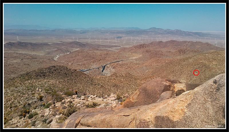
Topic:
The Island
Britain
|
Nice one of my favorite places. I usually park off the freeway near the bottom bridge. Theres a little turn out that will hide your vehicle. Theres also a couple of mines in which can be seen from the peak looking north. I haven't found as much scattered trash like old back packs up on the island. Passed through the area Saturday was 103 hats of to you! |
8/13/2017
Topic:
The Island
Britain
|
 This picture of yours shows one of the mines. This one was being worked on to about 5 years ago. In one of the Desert Magazines I think around 1940 or 50 mentions 2 mines , one is near the Hwy 8 exit to Myers and the other in the middle of the Island. This picture of yours shows one of the mines. This one was being worked on to about 5 years ago. In one of the Desert Magazines I think around 1940 or 50 mentions 2 mines , one is near the Hwy 8 exit to Myers and the other in the middle of the Island.
 |
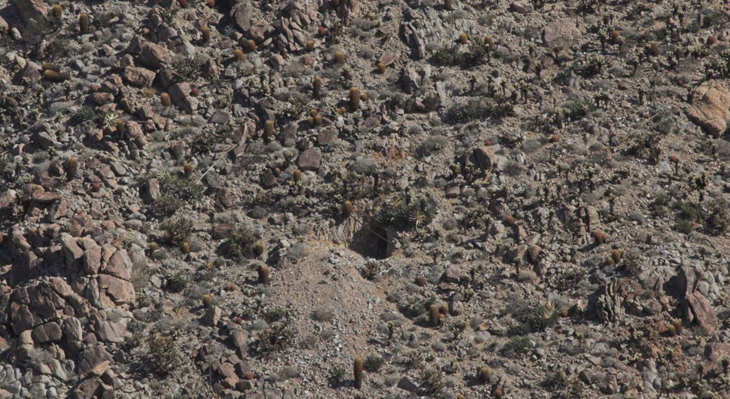
8/17/2017
Topic:
The Island
Britain
|
The garnets mines are mentioned in this article. I've found the mine its about 2/3 of the way to the mine in your picture but more east.
http://dezertmagazine.com/mine/1957DM06/index.html. |
8/17/2017
Topic:
The Island
Britain
|
rockhopper wrote:
Britain, Do you know what they were mining? I am guessing Gold.
I think garnets, the area is loaded with them. Close up of mine.
  |
8/19/2017
Topic:
Davies Valley and Pinto Canyon
Britain
|
The map from 1946, the areas labeled as springs would they be water springs? I haven't been in the south-west corner yet. But will put this on the list of todo. |
8/20/2017
Topic:
The Island - Inko BM
Britain
|
Ok Roasting pit. Seen a few. |
8/21/2017
Topic:
Davies Valley and Pinto Canyon
Britain
|
tommy750 wrote:
Britain wrote:
The map from 1946, the areas labeled as springs would they be water springs? I haven't been in the south-west corner yet. But will put this on the list of todo.
I've see water near one of the three springs (Juniper). Don't see any of them listed as springs on topo maps however.
Thanks does appear they went through in winter. I'll check some of them out later. |
8/21/2017
Topic:
Exploring the Service roads above the Carrizo R&R
Britain
|
tommy750 wrote:
Agree, that's a neat place to explore. Think we may share the same taste in artifacts
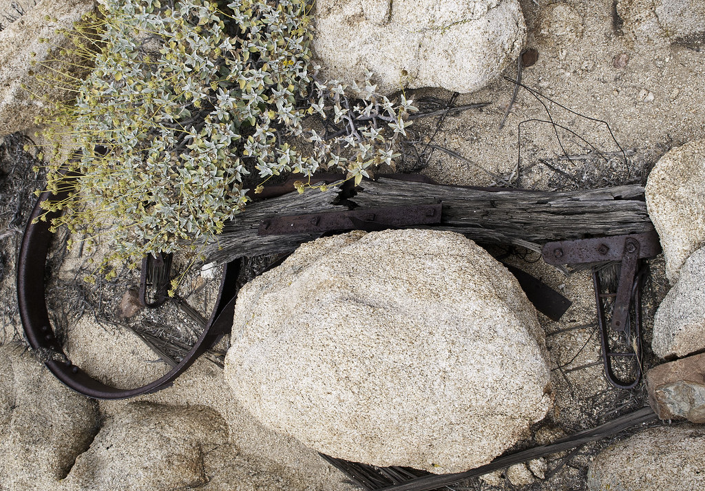 Yolk by tomteske, on Flickr Yolk by tomteske, on Flickr
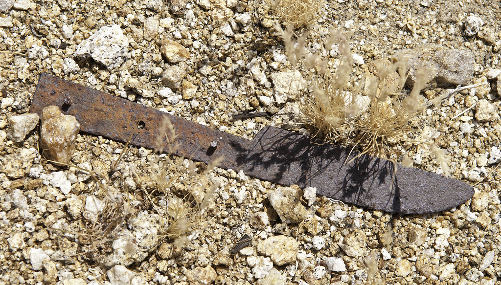 Knife by tomteske, on Flickr Knife by tomteske, on Flickr
Haha thats the same wheel and mounting bracket and looks like the same knife! |
8/24/2017
Topic:
Indian Hill Pictographs
Britain
|
I wonder what part of the Indian culture did the artist play? Was he/she just a regular so to speak. |
8/25/2017
Topic:
The Island - Inko BM
Britain
|
I caught these guys up on the eastern mesa of Table Mountain. One is tagged. I saw the same bunch a month earlier at the lower bridge on 8. Picture was taken early May.
 |
8/27/2017
Topic:
The Island - Inko BM
Britain
|
Well they are not easy to find and photo. I see them from a distance and it seldom at least for me to catch them close-up. I've packed the area from 8 were Devils goes under the freeway all the way up to Table in all directions. This year I'll go Eastern Table mountain down to Montero palms to see whats in that area or go up from Montero palms. |
9/7/2017
Topic:
The Island - PAH BM
Britain
|
PAH, I havent been on the northern end but I also show 2 positions for this. One on the far North and the other near where the 2 sides of the freeway are closest. Which one ? |
9/7/2017
Topic:
The Island - PAH BM
Britain
|
dsefcik wrote:
Britain wrote:
PAH, I havent been on the northern end but I also show 2 positions for this. One on the far North and the other near where the 2 sides of the freeway are closest. Which one ? It is the peak across from 1740, near the power line towers
OK got it. Doesn't look like any easy way up. |
9/7/2017
Topic:
The Island - PAH BM
Britain
|
Yes looks like the way I'll drive up to the end of what you can do on the side of 8 , The Calif Topo I use has the correct location . Its free. You can get it here. Loads on my Garmin fine and Base camp.
https://www.gpsfiledepot.com/ |
9/7/2017
Topic:
The Island - PAH BM
Britain
|
What are you using now for the tracks and item locations? |
9/7/2017
Topic:
The Island - PAH BM
Britain
|
My first was a Garmin 60csx , bright screen battery life good. Busted the screen climbing in the rocks then lost it on the eastern mesa of table mountain. No freeze ups worked great. I now have the Garmen Oregon 500. Screen brightness sucks rocks but can be read. Have 4 maps loaded, Baja, Italy , California and the stock map. No freeze ups, battery life soso depends on how many times I pull up the screen. Will last 16 hrs. Always carry spare batts. Can load satellite image overlays but only through Garmen. I use it more for tracks, trip meter and marking items. I'll use the compass with way points (added before) for getting to and from in rough stuff. Has funky camera never use it. |
9/8/2017
Topic:
The Island - PAH BM
Britain
|
So what was that stuck in the rock crack? Looks like a bullet casing. |
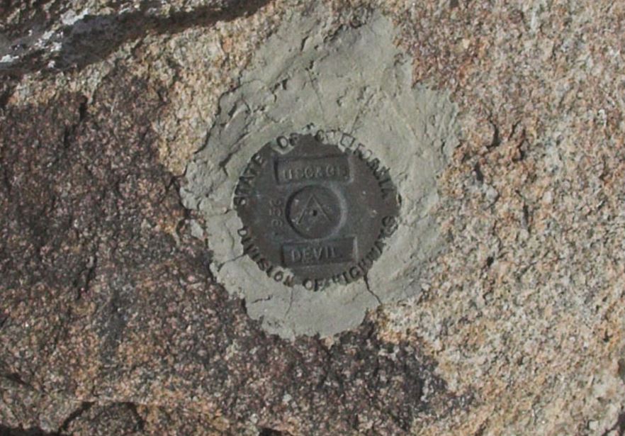
9/8/2017
Topic:
BM's
Britain
|
Are there any good resources for finding these? Some maps have them, have them on the wrong locations. I didnt know about these until reading the posts on this forum about them. So far I've walked over the INKO and MOAN BM's. And were close to others. I figure if I'm in the area why not and try and bag a few. |
9/8/2017
Topic:
The Island - PAH BM
Britain
|
tommy750 wrote:
Britain wrote:
So what was that stuck in the rock crack? Looks like a bullet casing.
Someone shoved a water bottle in the crack.
Haha crack is bigger then it appears! . |
9/8/2017
Topic:
BM's
Britain
|
Thanks NOAA site has some good stuff. |
9/9/2017
Topic:
BM's
Britain
|
Yes I'll use that as a source also. Just double check the gps. If theres 2 location check both if possible. |
9/9/2017
Topic:
The Island - PAH BM
Britain
|
Who names these things. Spring? Was there a Spring there? I may hopp across the freeway to look at LOAF on the way out Sunday. |
9/9/2017
Topic:
The Island - PAH BM
Britain
|
Prob short for Mountainsprings. |
9/9/2017
Topic:
The Island - PAH BM
Britain
|
Seen where you went up today to POH. Bee line!. LOAF yup Sugarloaf. |
9/9/2017
Topic:
The Island - PAH BM
Britain
|
Guess I wont run across the freeway after all. |
9/10/2017
Topic:
North McCain Valley
Britain
|
I caught one of the base sections @ Buckman Springs. Made in Korea. |
9/10/2017
Topic:
North McCain Valley
Britain
|
Its tragic whats happened to McCain area with power lines and turbines. Last time I was there in 2002 we packed down the trail to Cranebrake. Hoping find some of the McCain history. In the 70's we tested our rock climbing skills on the big chunk of granite. I dont remember the name of it anymore. Did loose some anchors in it.
edited by Britain on 9/10/2017 |
9/10/2017
Topic:
The Island - PAH BM
Britain
|
Well I bagged that tough Spring BM today. Heck of a hike! |
9/10/2017
Topic:
BM's
Britain
|
Though not a BM I found this near the Turbine that collapsed south of 8. I didn't have the gps so no exact location.
 |
9/10/2017
Topic:
BM's
Britain
|
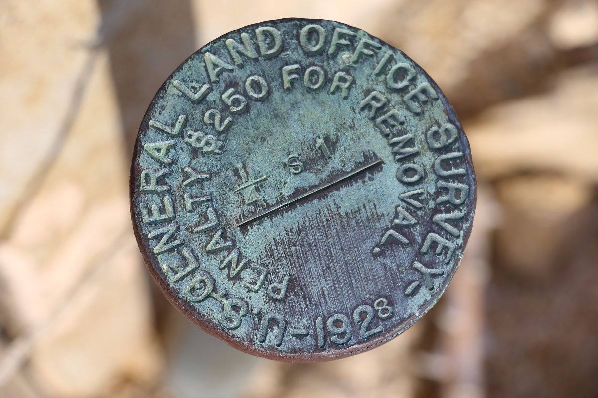
Question, Why would it be 1/4 S on S33? Caltopo survey map.
edited by Britain on 9/10/2017
edited by Britain on 9/10/2017 |
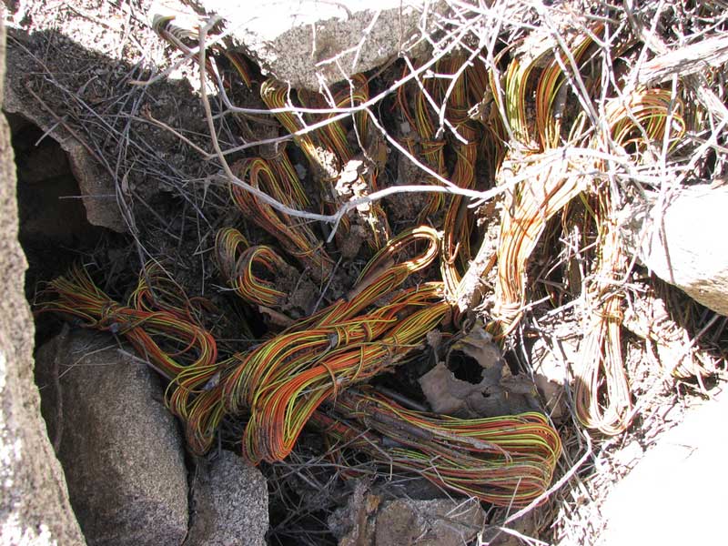
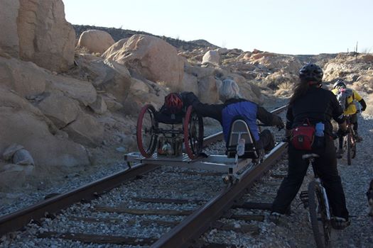
9/10/2017
Topic:
Railroad Police
Britain
|
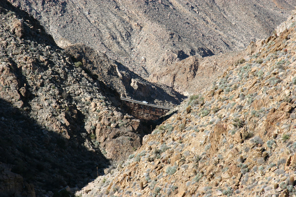
Yes they do exist. Picture taken in 2014 on the hill south of Goat Canyon. They have drop down wheels that fit the track. I think the next tunnel is partially blocked from a slide.
edited by Britain on 9/10/2017 |
9/10/2017
Topic:
BM's
Britain
|
Thanks makes sense.. I'm sort of familiar been working with Plat maps. I'll gps it next time to see how it matches up. . |
9/11/2017
Topic:
BM's
Britain
|
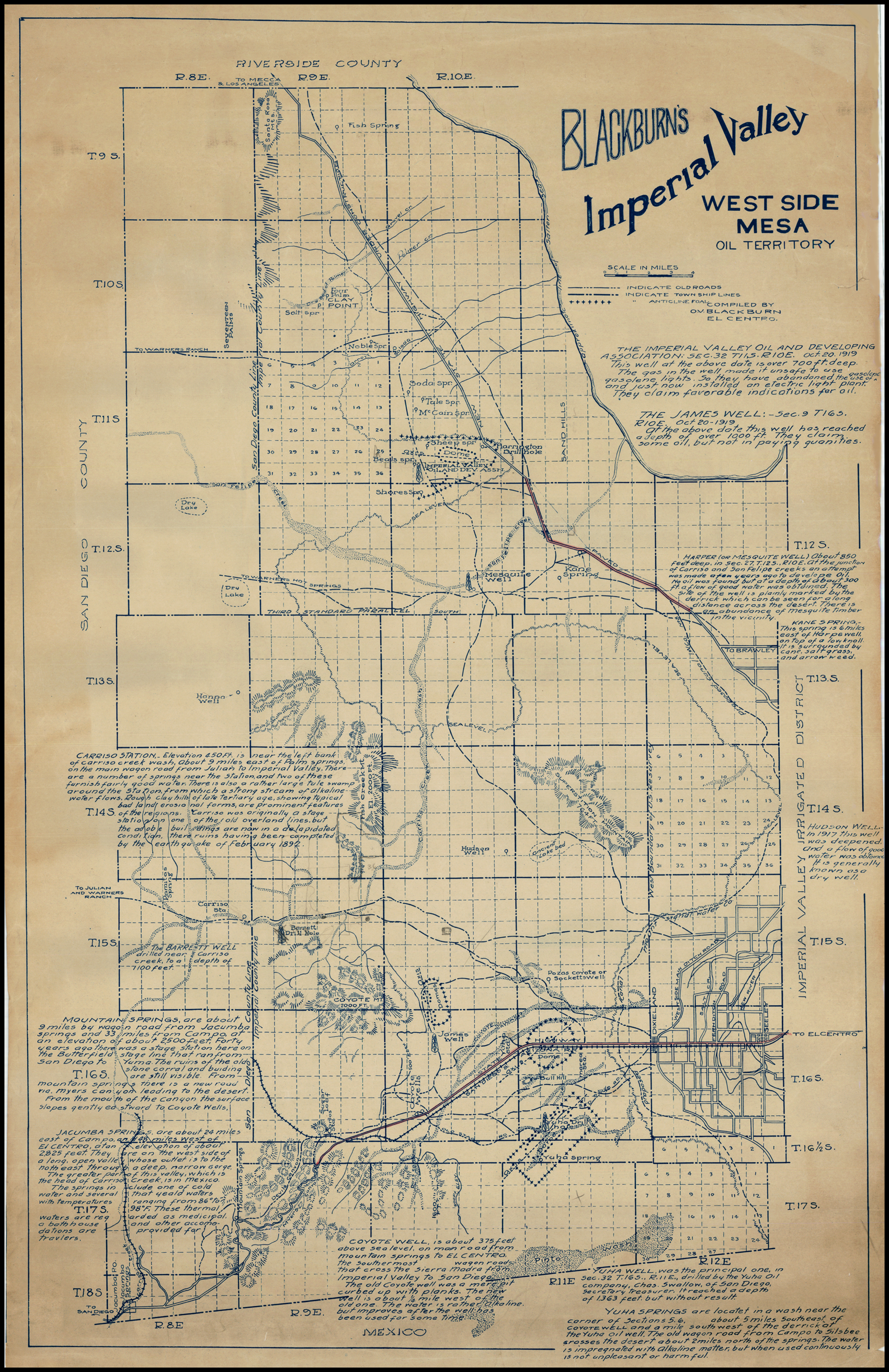
I was wondering why a 1/4 section was marked. So I dug into some old maps. Didn't find the reason yet but found this cool map from 1910 of Western Imperial County. Its a bit large.
edited by Britain on 9/11/2017 |
9/15/2017
Topic:
North McCain Valley
Britain
|
Interesting they must have recently updated GE. I see this else where also. |
9/15/2017
Topic:
Railroad Police
Britain
|
Last year the tracks were like a highway at rush hour. really full of people out enjoying what they do. I was surprised when I saw this one on the bridge. |
9/15/2017
Topic:
Railroad Police
Britain
|
This guy was pretty determined to do this. He wheeled from the east coast just to do the gorge.
 |
10/5/2017
Topic:
Photo hosting recommendations
Britain
|
Here's a link to a firefox and a google chrome plug-in so you can see all of the "broken" photobucket images....
Firefox... https://addons.mozilla.org/en-US/firefox/addon/photobucket-fixer/?src=cb-dl-recentlyadded
Google Chrome.... https://chrome.google.com/webstore/detail/photobucket-embedded-imag/ogipgokcopooepeipngiikdkpmcpkaon
Brings the pictures back. At least for now. |
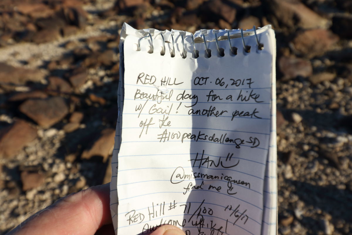
10/6/2017
Topic:
Weather Balloon
Britain
|
First hike of the season on Red Hill. Ended going up a canyon to stay in shade on the eastern side of the canyon. Bad choice upper end of the canyon ruined getting on top of Red Hill. But once I did get out of the canyon found the balloon.


And a self_adressed bag to send their junk back to them!
 |
10/6/2017
Topic:
Weather Balloon
Britain
|
Wonder what happens when one of these get sucked into a jet engine? I'll be mailing it back Saturday. |
10/6/2017
Topic:
Weather Balloon
Britain
|
Probably like a bird going in. Still, wouldn't want to be on any aircraft digesting anything through the engines. But for me a cool find.! |
10/9/2017
Topic:
Thorny desert weed
Britain
|
What is this stuff. Has lots of very small thorns. Rips your skin up. Stuff always seems to end up in groves, right in your path. Caused me today a lot of deterring. And those big flys, they follow you for miles. Wish I would have had a flamethrower!
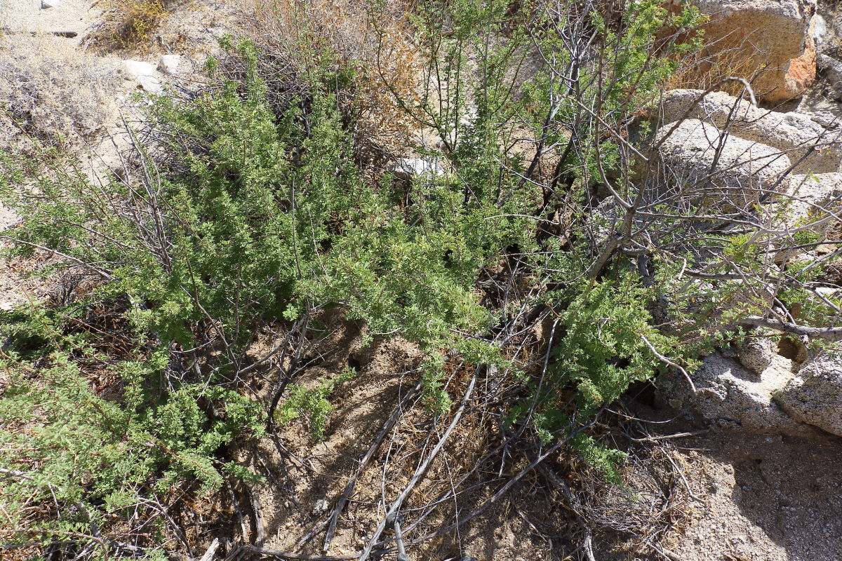  |
10/9/2017
Topic:
Thorny desert weed
Britain
|
dsefcik wrote:
Cat's Claw....
Thanks makes sense! |
10/11/2017
Topic:
Thorny desert weed
Britain
|
Got me a little cholla today. Those little ones that have broken off the ball. Had to take my pants off. Some of the spikes went through. But Love me some early morning hiking.
  |
10/12/2017
Topic:
Desert Night life
Britain
|
To have a faster wide open lens...
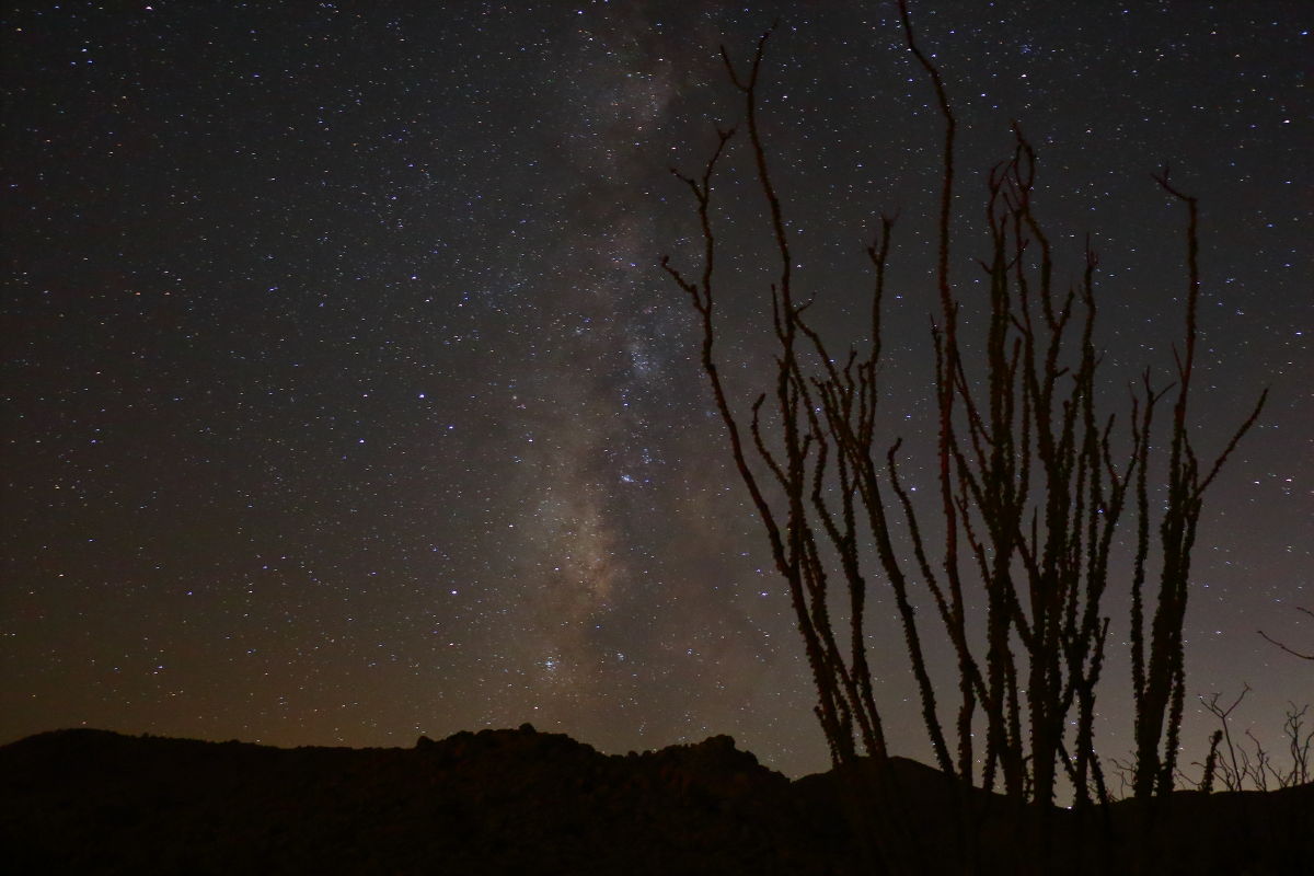 War of the worlds War of the worlds
 |
10/13/2017
Topic:
Thorny desert weed
Britain
|
Was in one of the big storm channels in Anaheim, there are thousands of homeless people. Just miles of them. I feel sorry for them. There are students living there. They just cannot afford to live in this area and this is the only option for them. It's truly sad this is happening. There's a line of what they can afford and moving to where they can afford. Most of them who I talked to are not of the crazy type. |
10/14/2017
Topic:
Desert Night life
Britain
|
dsefcik wrote:
Nice photos...I have not done any night shots for awhile. I have several Rokinon manual lenses, they are affordable and can get you into the faster, wider lens space. On my Fuji camera I have a 12mm F/2.8 which runs about $400.
Thats a good price for was low F and wide open. These were shot @ F/3.5 my wide open 10mm is at F/4.5 and the pictures are much darker and when applying more ISO much grainier. I haven't seen a reasonable priced low F wide open for Canon. I'm looking but I also want a better telephoto and that's 2K .
But the night temps were mid 70"s and clear out. Was a good night. |
10/14/2017
Topic:
Desert Night life
Britain
|
dsefcik wrote:
Britain wrote:
I haven't seen a reasonable priced low F wide open for Canon. I'm looking but I also want a better telephoto and that's 2K .
The Rokinon for Canon $399
Otherwise, yeah...Canon = $$$
Let me look into this. Mine is not a full frame. Price is right. Thanks |
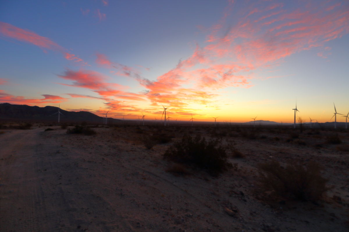
10/15/2017
Topic:
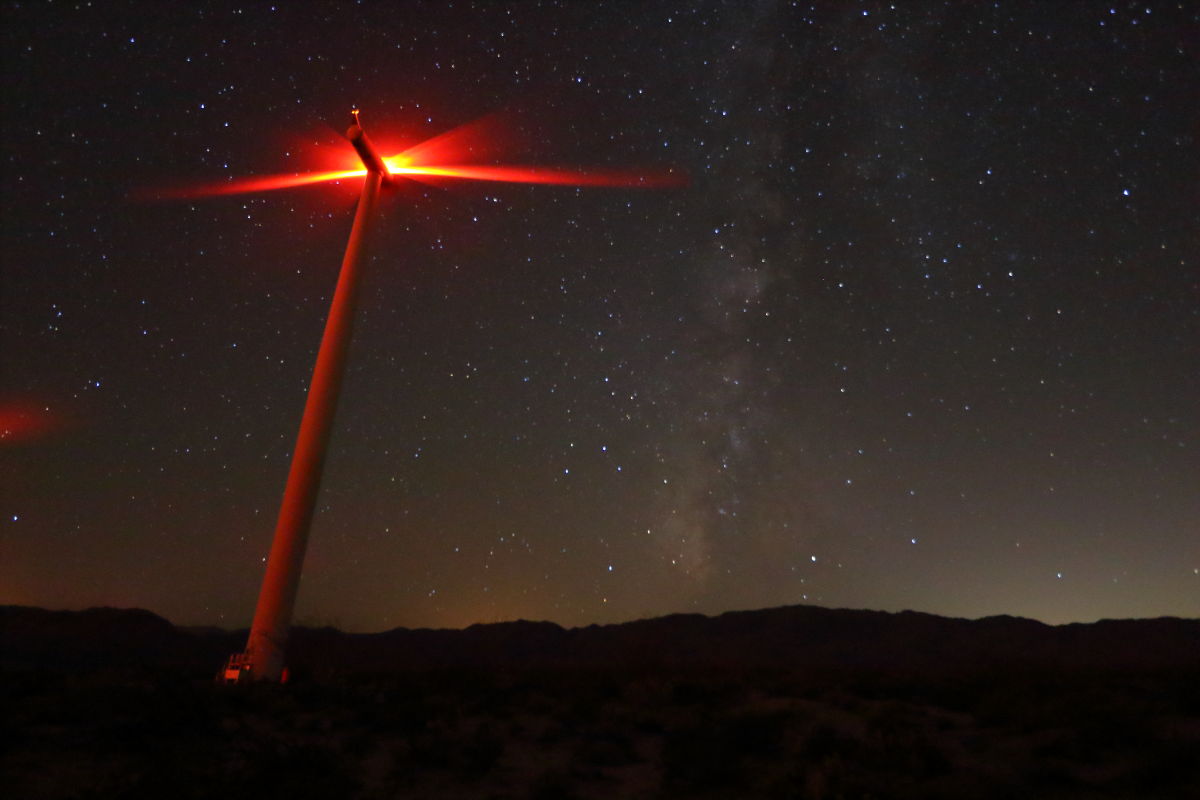
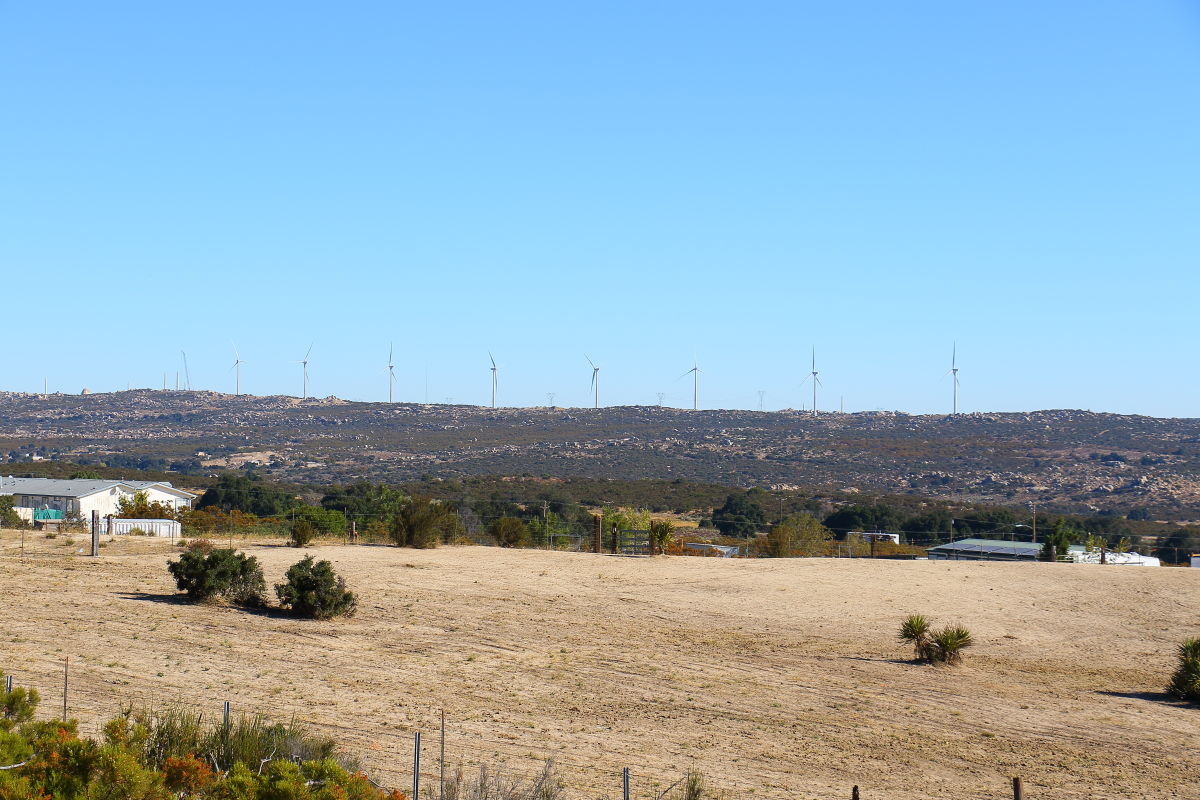
McCain and Wind Turbines
Britain
|
10.13.2017 Most of the poles are up, many are already assembled. A quick shot from the freeway. I would guess they will all be up in a month.
 |
10/18/2017
Topic:
McCain and Wind Turbines
Britain
|
tommy750 wrote:
Those things go up like weeds. Should be enjoyable relaxing at Cottonwood with the nearby 2,000 lumen red LEDs flashing every few seconds and the whoosh whoosh providing audio.
The R&R tracks at night when cooling down pop and crackle. But the Turbines also have the same noise. But there's was another noise I heard it sounded like the transformers were unloading there was a "Thumping" like sound periodically.
edited by Britain on 10/18/2017 |
10/18/2017
Topic:
McCain and Wind Turbines
Britain
|
About a month ago they left some of their junk at Buckman Springs.
 |
10/18/2017
Topic:
McCain and Wind Turbines
Britain
|
I would guess the lighting would be the same for Power poles and such. Never thought about the lighting requirements per FAA. Good info. |
10/18/2017
Topic:
McCain and Wind Turbines
Britain
|
Well, heres a FAA doc on lighting requirements.
https://www.faa.gov/documentLibrary/media/Advisory_Circular/150_5345_43g.pdf |
10/19/2017
Topic:
Ute Rock art
Britain
|
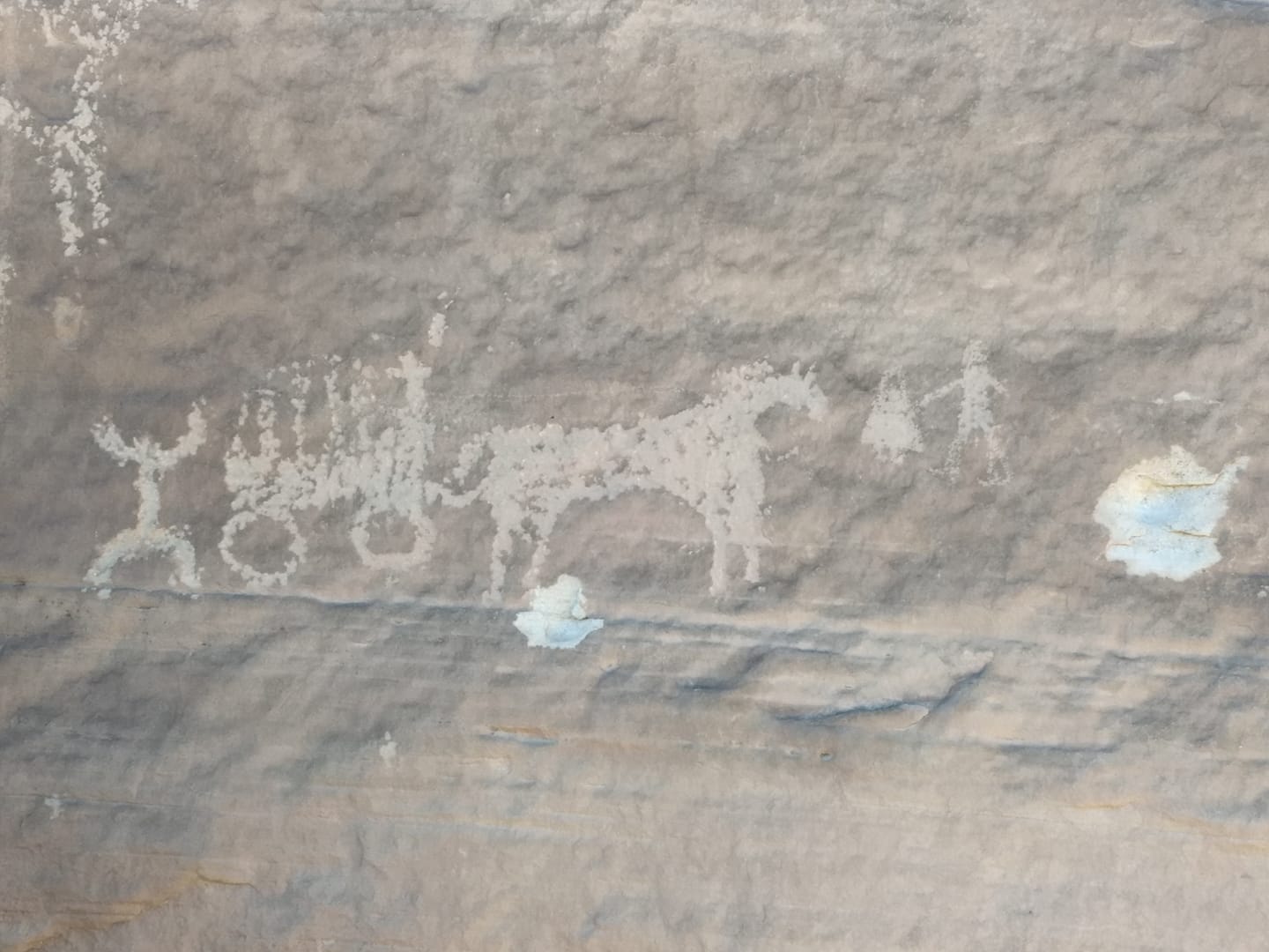
This was posted on a Rock art forum. I thought it was funny but full of history.
 |
10/25/2017
Topic:
Memorials in the Park
Britain
|
That's pretty cool! |
11/1/2017
Topic:
Red Hill
Britain
|
Took in an early morning hike up to Red Hill. Took the car and parked off S2. Some helicopters flying about.
Some notes in the bottle on top.
Took 100-400mmthe and snapped some of the wind turbines over at McCain.
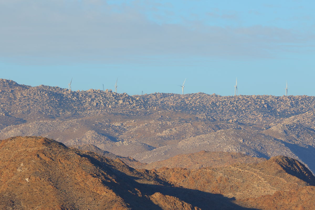
Another 100-400mm shot. Hey, what are all those trucks doing around my car! Some trouble a brewing?
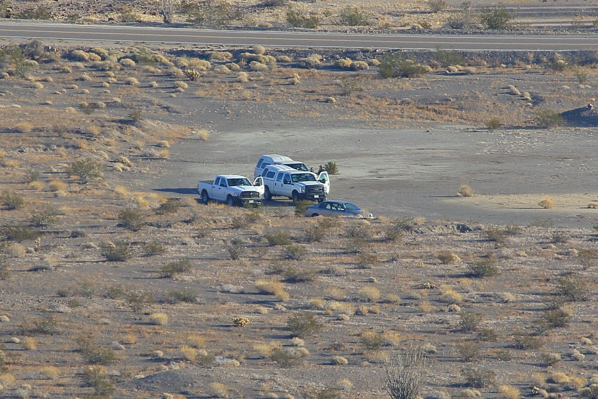
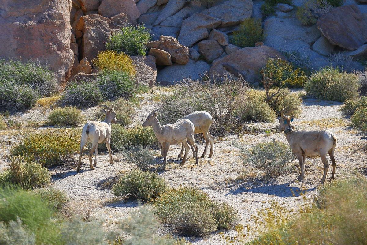
No, its only fish and game. They were out tagging and adding the tracking devices to the big horn sheep, at least to the ones they could chase down.
 |
11/3/2017
Topic:
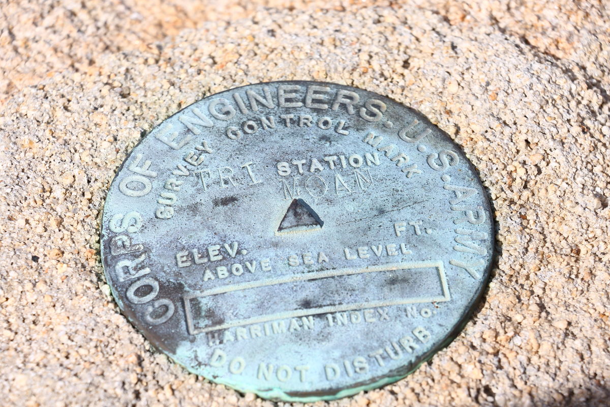
Moan Benchmark and I found a roasting pit.
Britain
|
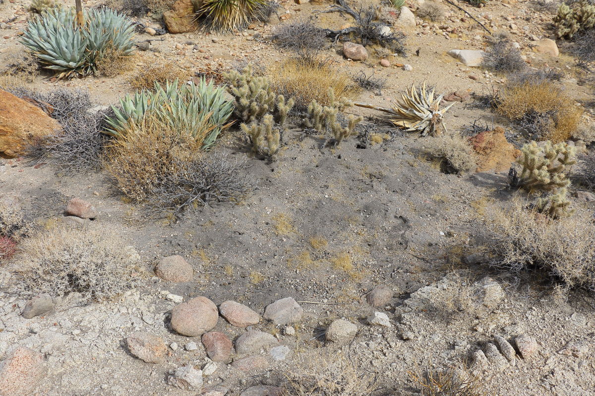
Tagged the Moan Benchmark today. I came up from the Indian Hill area and went down the west side of Moan to the R&R service road and out. About 200 ft down I came across a clean trail. Think a sheep trail so I followed it down to a flat area. Here's where the roasting pit was. You could smell the ash. Found 2 roasting pits.
Roasting pit. This was a really steep area. A small flat area and the pit. The trail did not go any farther in the direction I was heading ..down.
 |
11/3/2017
Topic:
Red Hill
Britain
|
tekewin wrote:
That's a fun hill with red volcanic rocks. What a zoom you must have on your camera. I went back and looked at my photos from the summit and McCain was a fuzzy ridge. Definitely peanut butter and jealous of that camera set up. Thanks for posting.
Sometimes all the glass I tote around for the camera makes hiking a bit of a journey. |
11/4/2017
Topic:
Moan Benchmark and I found a roasting pit.
Britain
|
dsefcik wrote:
Nice roasting pit...amazing how many there are out there...
Thanks to you I've got my eye open for them. |
11/9/2017
Topic:
Moan Benchmark and I found a roasting pit.
Britain
|
rockhopper wrote:
According to Marshal South's book. Marshal and his family were using roasting pits in the 1940's in and around Ghost mountain. He went on to say that the roasted Agave hearts were very tasty. Wonder how old your find was?
I found that roasting pit getting off of Moan. About 100 ft down on the west side I came across a trail running horizontally. The north end going up south going down. Downward took me straight into the roasting pit. I would guess because most of it is on the surface, erosion would remove them in short time. That one was being used over and over. They dumped the old ash about 10 ft away. I didn't follow or look into the trail, it wasn't going in the direction I wanted. I should have spent a little time looking into it. Perhaps in the future, I might. It's really steep, slippery and full of cactus. |
11/9/2017
Topic:
Indian roasting pits and Yoni's
Britain
|
Admin, please delete this thread, it is redundant. |
11/26/2017
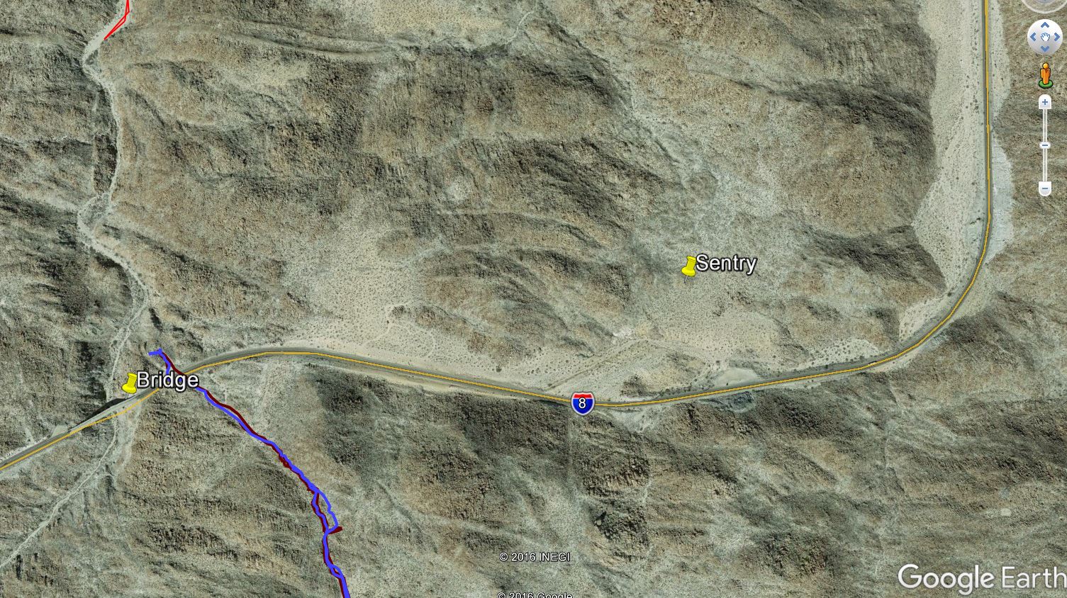
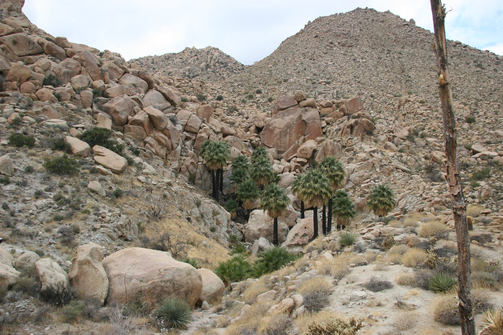
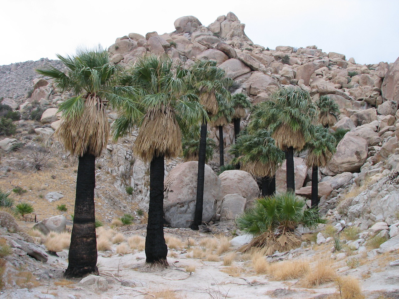
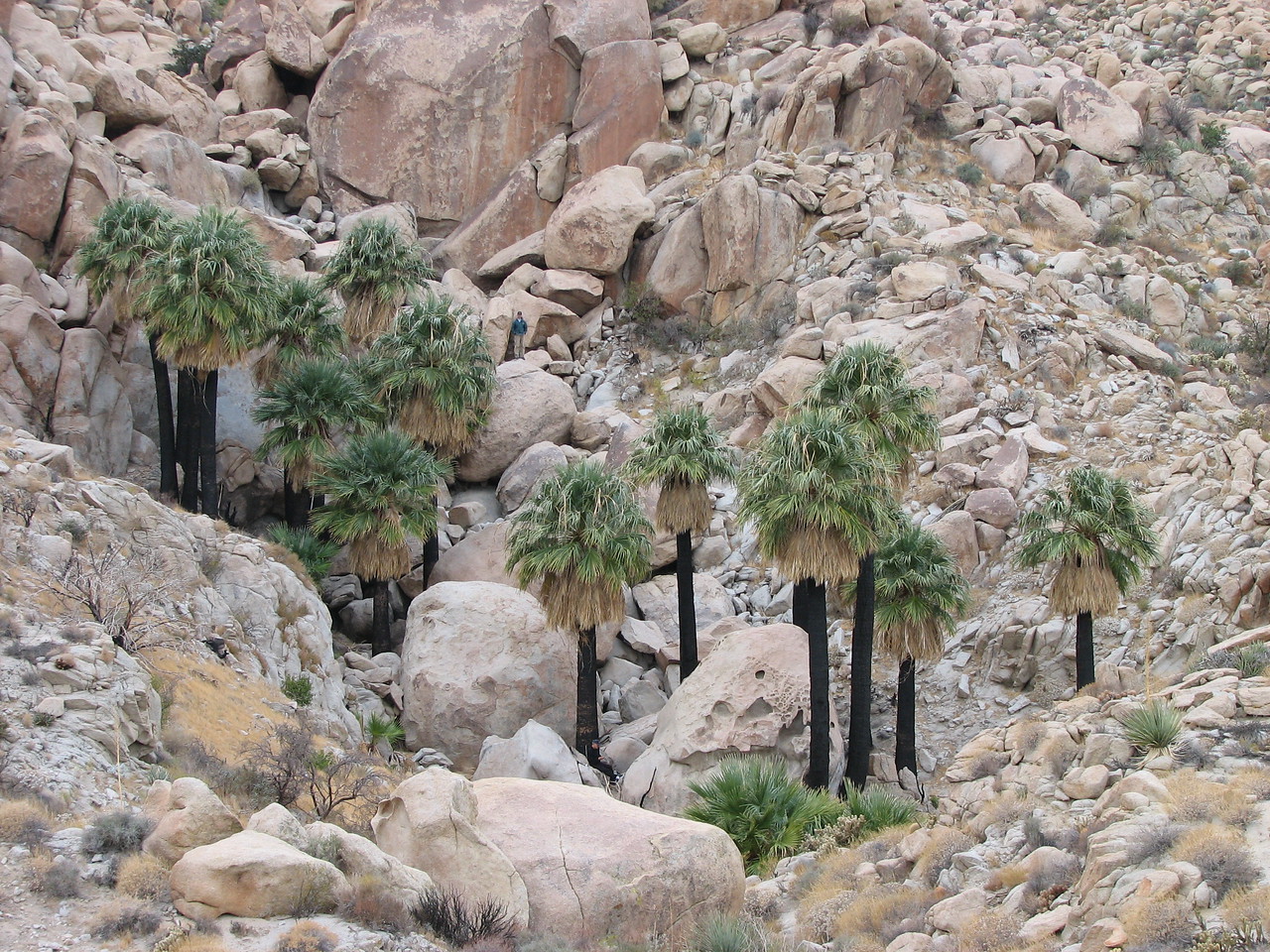
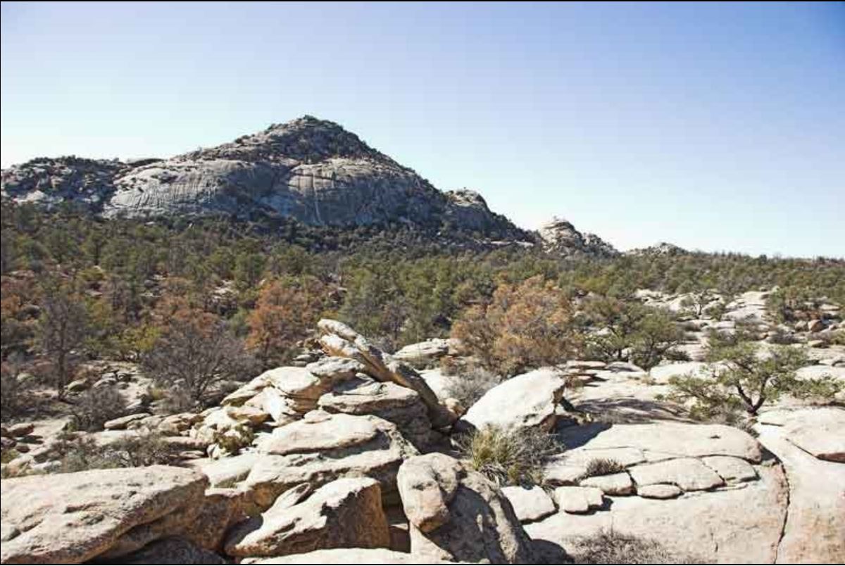
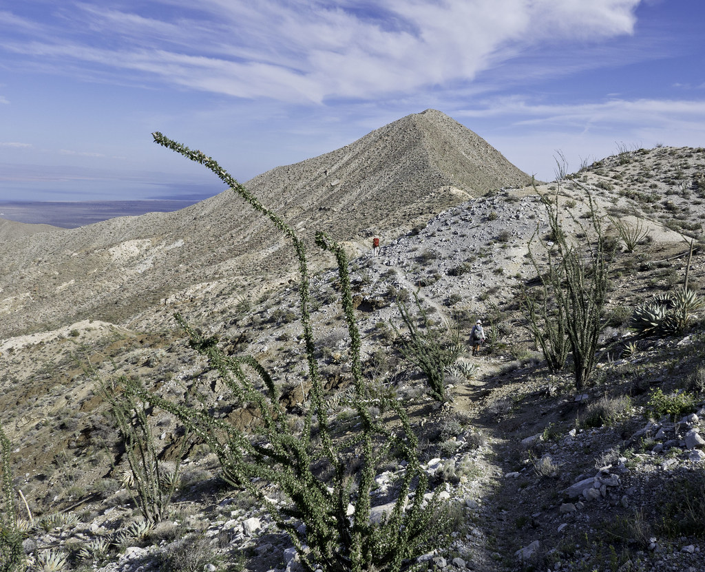
Topic:
Mountain Springs to Juniper springs
Britain
|
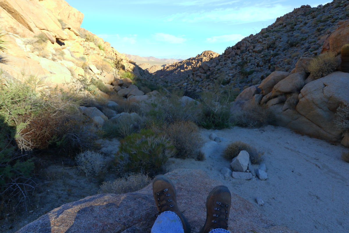
Bit warm out in the mid 90's. Made it to the Juniper, 3 miles 2.5 hrs. Will be faster next time around.
Storm Drain
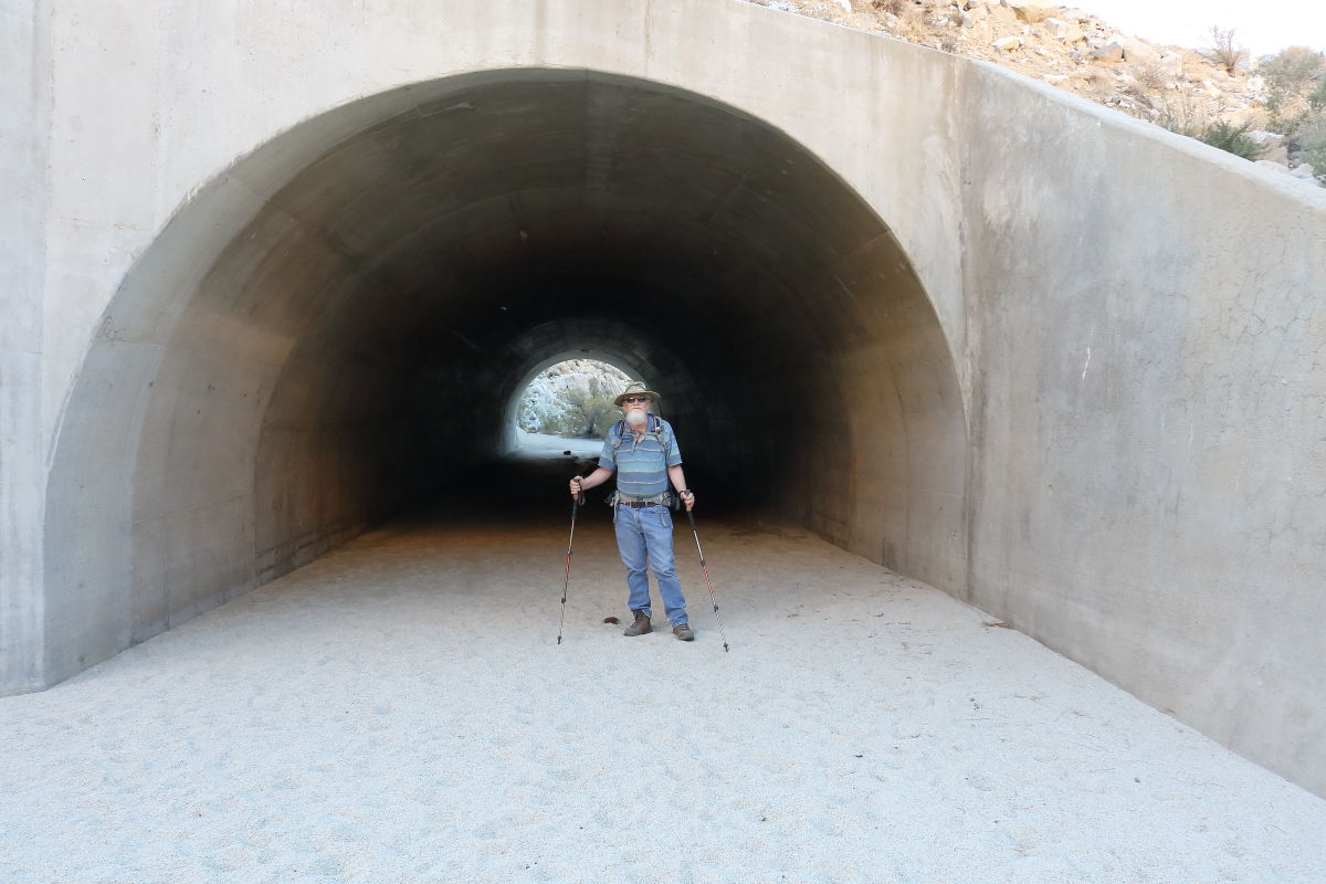
Canyon after boulder creek.
First rock waterfall.
Wife made short work of it.
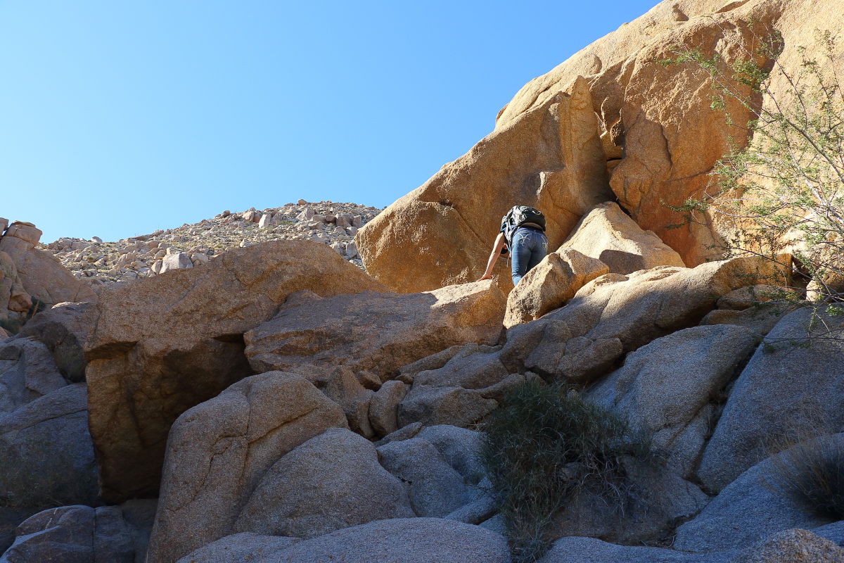 Making final to grove. Making final to grove. 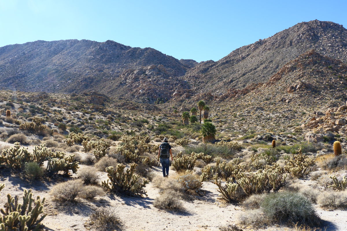 Enjoying the shade. Had lunch poked about. We got a late start and went through a lot of our water supply to get to the second grove. The palms were burned. Enjoying the shade. Had lunch poked about. We got a late start and went through a lot of our water supply to get to the second grove. The palms were burned.
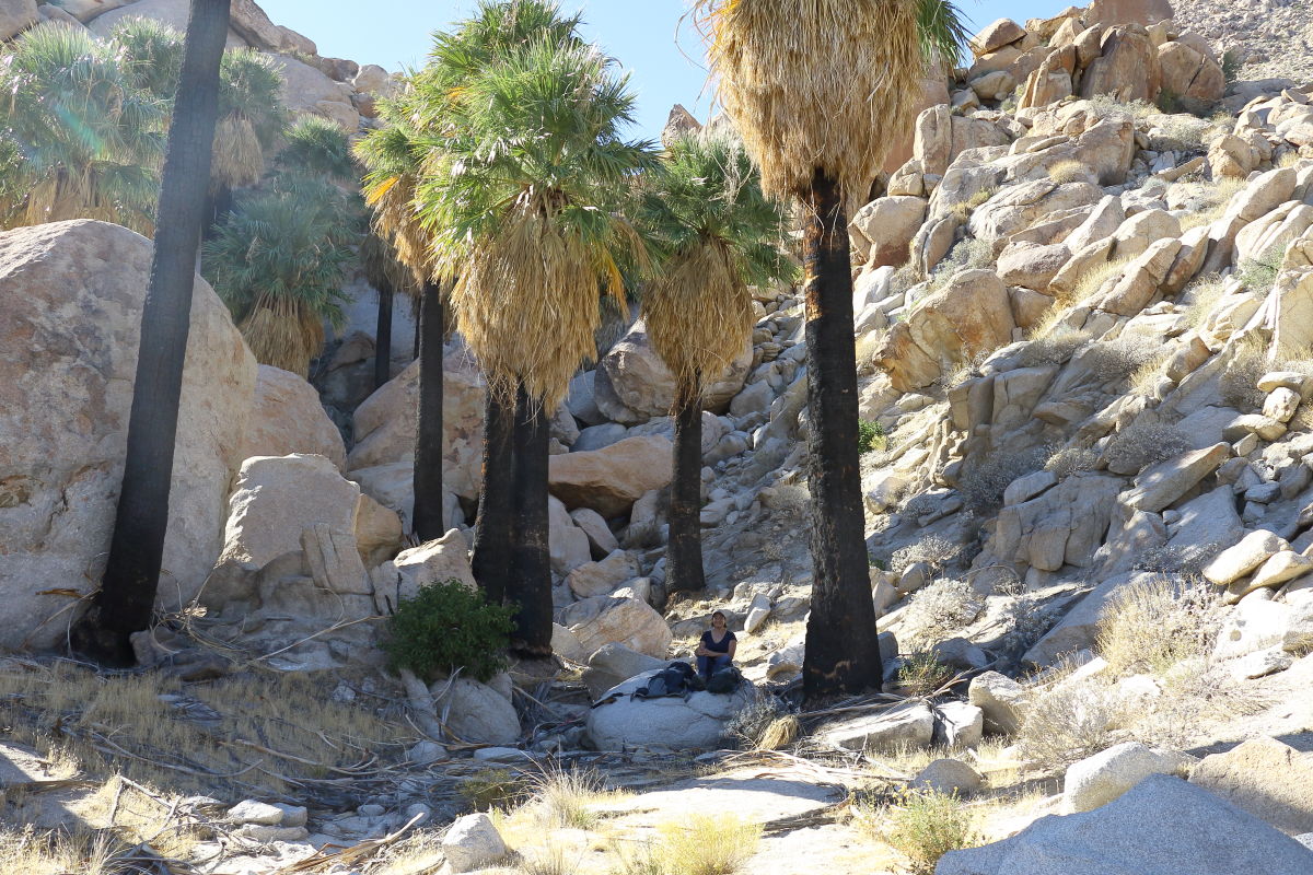
edited by Britain on 11/26/2017 |
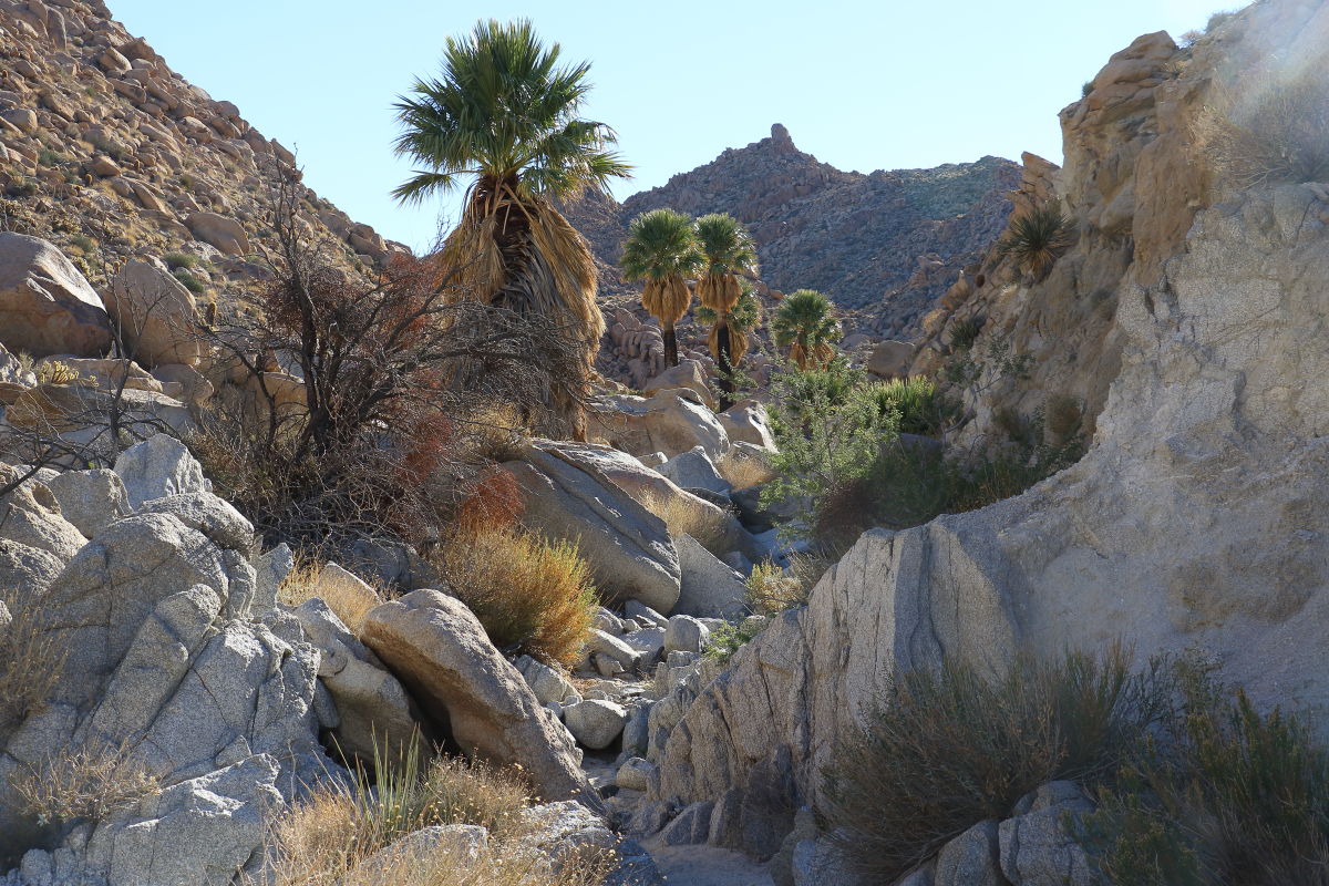
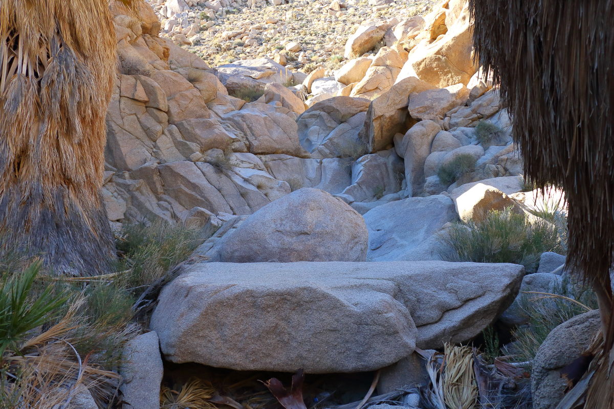
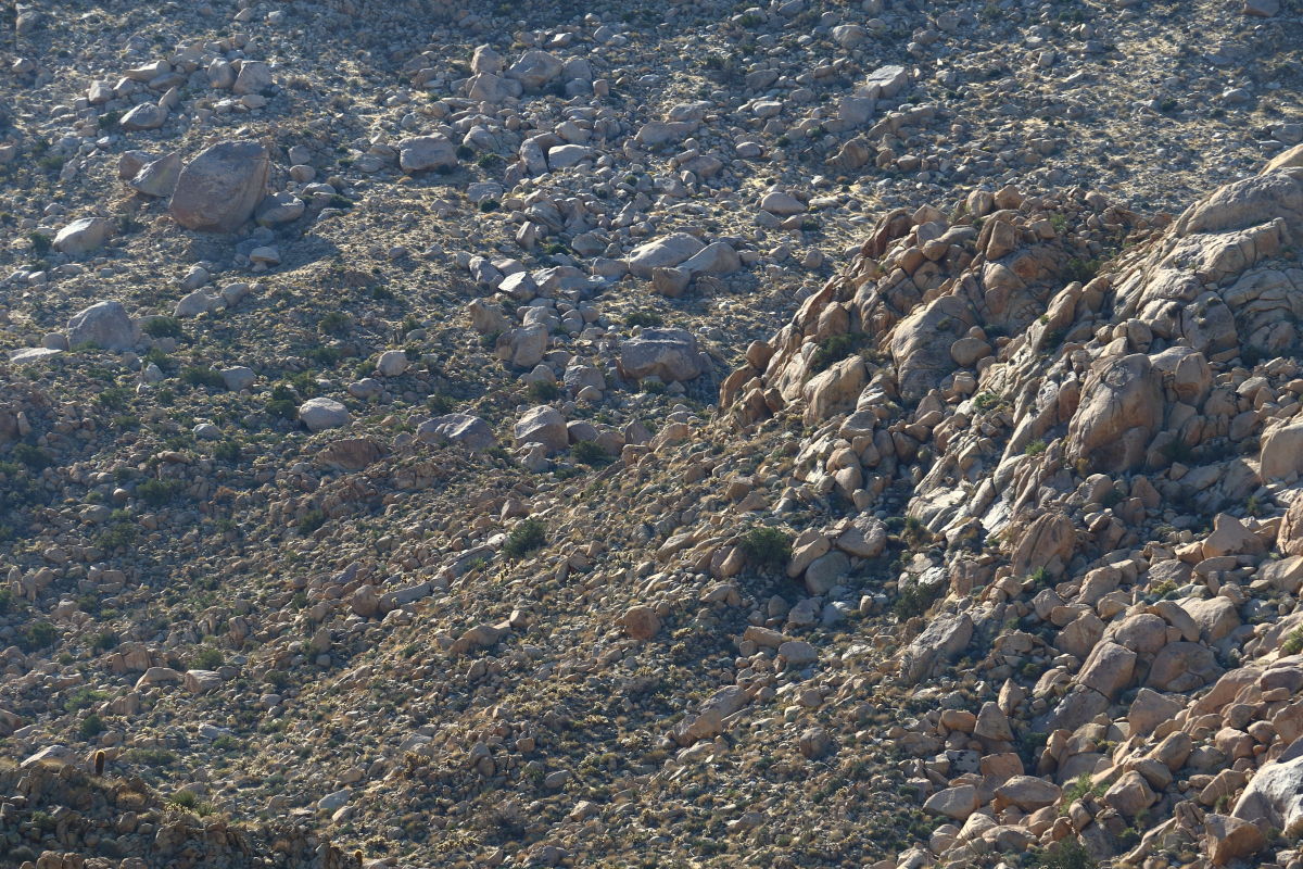
11/26/2017
Topic:
Mountain Springs to Juniper springs
Britain
|
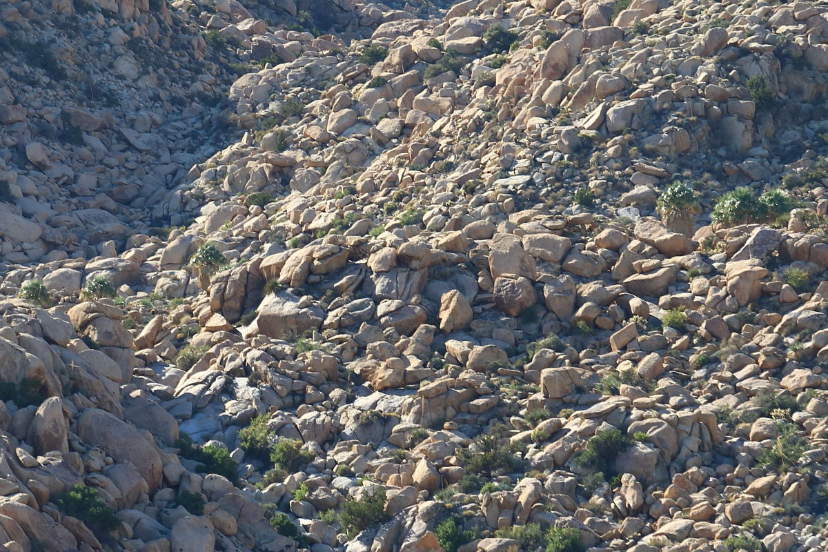
Pretty much bone dry. Guess if you dig around you might come up with some water. That's some rocky stuff on the right. Couple pictures here.
Close up rocky right side
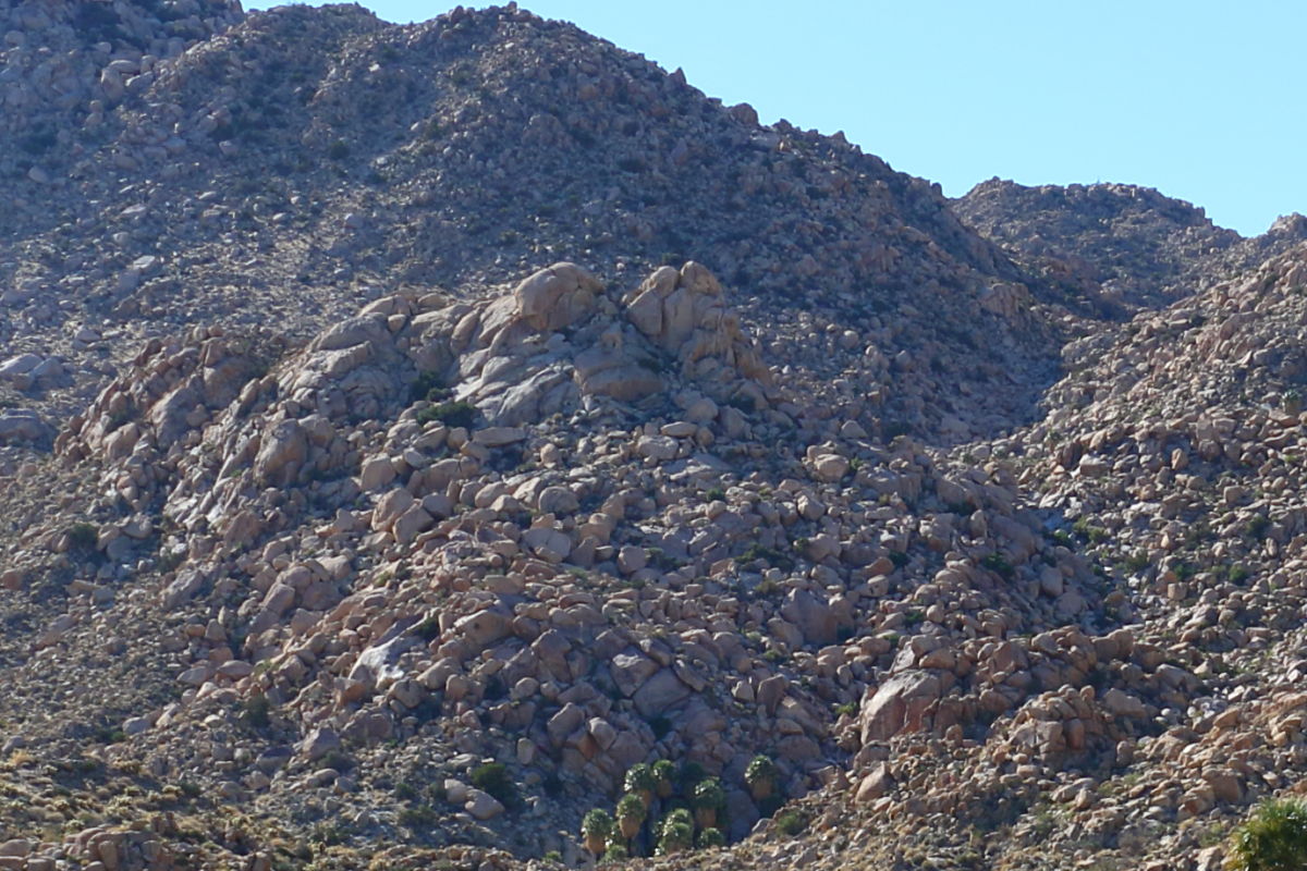 Left side Left side
 Upper palm grove. The pictures I've seen are not this rocky. Perhaps an illusion. Upper palm grove. The pictures I've seen are not this rocky. Perhaps an illusion.
 |
11/26/2017
Topic:
Mountain Springs to Juniper springs
Britain
|
Usually, carry a powder hydrator that we mix into a water bottle, forgot the bottle. Wife was a bit pissed about that. Went through 5.5 ltrs of water with .25 left when we got back to the jeep. |
11/28/2017
Topic:
Rockhouse, Jacumba Jim, Four Frogs and East Fork
Britain
|
The picture of Gary above Carrizo, I've pretty much hiked everything in the canyon that's going east. Haven't done anything on the west side. May go up the one you guys did tomorrow. Looks like a great hike. |