6/1/2020
Topic:
Colorado Desert From The Air
tommy750
|
Scooter wrote:
Thank you for a very interesting trip report. It sure has been a slow spring in the desert and on the blog. Thanks Again
2020 sure has been a terrible year for just about everything including enjoying the desert. Hopefully things will change soon |
6/1/2020
Topic:
Colorado Desert From The Air
tommy750
|
Rocko1 wrote:
Tommy you have a fantastic eye for finding things! Great pictures and finds. I have considered a drone but have reservations after being out in nature and having them buzz around near me-the noise can be quite off putting.
Agree, those yahoos flying drones all over public spaces or 2 ft away from the wildlife need to stay away. That said, really think it would be a great addition to park volunteers needing to document change over time at sensitive cultural sites. For example, just noticed by drone photos someone had been substantially altering a well known spoked wheel geoglyph near Ocotillo in the past years. Changes were made to another rather obscure geoglyph as well. Do-gooders? Kumeyaay? I don't know, but I forwarded the info to BLM for follow up. Not sure what the sheep counters would have to say about drones as a supplemental viewing platform. Drones can be annoying and noisy but many including mine are rather invisible and inaudible at about 50 ft overhead and may not be an issue for careful wildlife observers.
One last thing. I never have GPS enabled for cameras and phones but your drone will. Had to remind myself to remove all GPS data from pics of sensitive sites. |
6/2/2020
Topic:
Colorado Desert From The Air
tommy750
|
Sound like everyone is in agreement drones are awesome and terrible depending on how they're used. Ziphius, nice article on seal counting. My cheap drone camera now has more MP than the one in your article which is from 2011. Your Sony mirrorless setup is probably a completely different story! My little drone in intentionally 249 grams, one less than required for an FAA certificate which is .55 to 55lbs.
What interests me the most is high resolution panoramas and I think our area has a lot of possibilities. |
6/2/2020
Topic:
Cuyamaca SP
tommy750
|
Nice pics Rocko1. Like the one from the top. |
6/5/2020
Topic:
Colorado Desert From The Air
tommy750
|
rockhopper wrote:
Nice finds. Neat adventure Tommy! Were the camping circles on the benches above the ancient lake shore line? The multiple lake fills over the past 12,000 years ( At least 8 full fills but probably many more) supported large populations at various periods of lake fills. Lake fills may have lasted 50 years or more with constant inflows from the Colorado river. Population peak may have reached 10,000 around the lake. Those stone tools could be 1000 years old or 10,000 years old.
Was exploring around Ocotillo and SW of the Coyote Mts. Lots of reported Archaic sites in that area. The Park spent a lot of time last year excavating such a site near Carrizo. The history of early man in this area is quite fascinating. The earliest first man site in San Diego is probably beneath the fancy homes south of the La Jolla Beach and Tennis Club. Just finished reading this book on the subject and would definitely recommend it for those interested in the topic: https://sunbeltpublications.com/shop/first-people/ |
6/5/2020
Topic:
Colorado Desert From The Air
tommy750
|
Rocko1 wrote:
tommy750 wrote:
Sound like everyone is in agreement drones are awesome and terrible depending on how they're used. Ziphius, nice article on seal counting. My cheap drone camera now has more MP than the one in your article which is from 2011. Your Sony mirrorless setup is probably a completely different story! My little drone in intentionally 249 grams, one less than required for an FAA certificate which is .55 to 55lbs.
What interests me the most is high resolution panoramas and I think our area has a lot of possibilities.
What is your drones MP count Tommy? Some high res panos would be pretty fantastic.
Mine is 12.7MP and not bad for the price. Definitely could stitch a few pics together in Photoshop for a decent pano. |
6/5/2020
Topic:
Colorado Desert From The Air
tommy750
|
ziphius wrote:
Tommy yeah the article is a little outdated! We're using a 36 MP Sony A7R on a hexacopter these days.
You have any pics you could post from your work with that setup?? Would be very interesting to see. |
6/5/2020
Topic:
Colorado Desert From The Air
tommy750
|
ziphius wrote:

Gray whales from 150 ft altitude. Custom hexacopter with Sony A7R mirrorless body.
tommy750 wrote:
ziphius wrote:
Tommy yeah the article is a little outdated! We're using a 36 MP Sony A7R on a hexacopter these days.
You have any pics you could post from your work with that setup?? Would be very interesting to see.
edited by ziphius on 6/5/2020
So Ziphius you get paid to do this stuff?? Dang. Guess some of us got those good guidance couselers  |
6/9/2020
Topic:
Colorado Desert From The Air
tommy750
|
If you search "La Jolla Archaeological Area" or "Spindrift Archaeological District" you get a few hits on archaeology reports generated in association with La Jolla Shores area building permits. They're an interesting read. Here's a pic from Gallegos' book showing where the Spindrift site is located. Reported C14 dating of midden deposits is as far back as 9000 years before present with midden deposits 1-8 feet thick. The site has experienced continuous occupation over that extended period because who wouldn't want to live on Spindrift Drive?
 W-1 Spindrift by tomteske, on Flickr W-1 Spindrift by tomteske, on Flickr |
6/9/2020
Topic:
Diablo BM
tommy750
|
Nice TR Rocko1. Have only been there once in 2014 but the register had stuff back to 1955. Think there were two register caches near the benchmark if I recall correctly.
 Carl Whitefield (2018_09_25 07_05_23 UTC) by tomteske, on Flickr Carl Whitefield (2018_09_25 07_05_23 UTC) by tomteske, on Flickr
 1957 by tomteske, on Flickr 1957 by tomteske, on Flickr |
6/18/2020
Topic:
Colorado Desert From The Air
tommy750
|
rockhopper wrote:
Tommy. Book is on order. Looking forward to adding to the Library. On topic, Back in the 80's during my "Surfing Years" we would see scuba divers coming out of the ocean with stone tools and grinding metates from off shore. This was in the N. County near Encinitas. The divers could only go so deep so alot is still out there. 10,000 years ago the shore line was around 300 feet lower and up to miles out from the current shore line. At the Spindrift site in La Jolla the ocean bottom drops off quickly and the old shore line was only a few hundred yards out.
Here's an interesting article on La Jolla off shore archaeology. Fascinating stuff.
https://www.lajollalight.com/news/health-science/sd-scripps-center-marine-archaeology-20170803-story.html |
7/13/2020
Topic:
Owens Valley
tommy750
|
Not exactly Anza Borrego but pretty much the same stuff: rocks and sand, heat, sheep, hiking, rock art, artifacts, exploring, you know. When the wife's planned trip to Baja fell through (expired passport and extension of travel ban), we decided to head to the Owens Valley area. Was going to be hot but figured we could camp either in the eastern Sierras or in the White Mts to stay cool and do whatever during the day. Made it to Indian Wells Canyon (near Inyokern) the first night and explored a rock art site reportedly dating mainly to the "Ghost Dance" period of the 1890's. The site had some nice pictos with some reportedly showing a rider with a white hat, the prophet Wavoka. During the trip started reading a book on the Ghost Dance and highly recommend it: https://www.amazon.com/Gods-Red-Son-Religion-America/dp/0465015026
One of two sites in Indian Wells Canyon:
 Indian Wells Canyon Pano_lxx_0.58_0.90_1.50 by tomteske, on Flickr Indian Wells Canyon Pano_lxx_0.58_0.90_1.50 by tomteske, on Flickr
 IMG_4288 by tomteske, on Flickr IMG_4288 by tomteske, on Flickr
Was planning on visiting the second site in the morning but constant 30-50 mph winds became unbearable so we just packed up at 0300 and headed north. Ended up near a site called Ayers Rock, reportedly the most researched picto site in California. Also one of the most plundered.
Ayers Rock is the large boulder at ground level left ot the Joshua Tree.
 Ayers Rock Pano by tomteske, on Flickr Ayers Rock Pano by tomteske, on Flickr
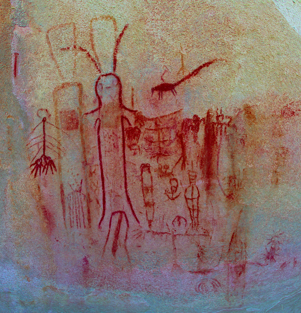 Ayers Rock Panel 1_lxx_0.40_0.84_1.14 by tomteske, on Flickr Ayers Rock Panel 1_lxx_0.40_0.84_1.14 by tomteske, on Flickr
Not your typical anthropomorphs!
 Ayers Rock Bunny by tomteske, on Flickr Ayers Rock Bunny by tomteske, on Flickr
Very nice sheep and antelope panel.
 Ayers Rock Panel_lxx_0.42_0.84_1.38 by tomteske, on Flickr Ayers Rock Panel_lxx_0.42_0.84_1.38 by tomteske, on Flickr
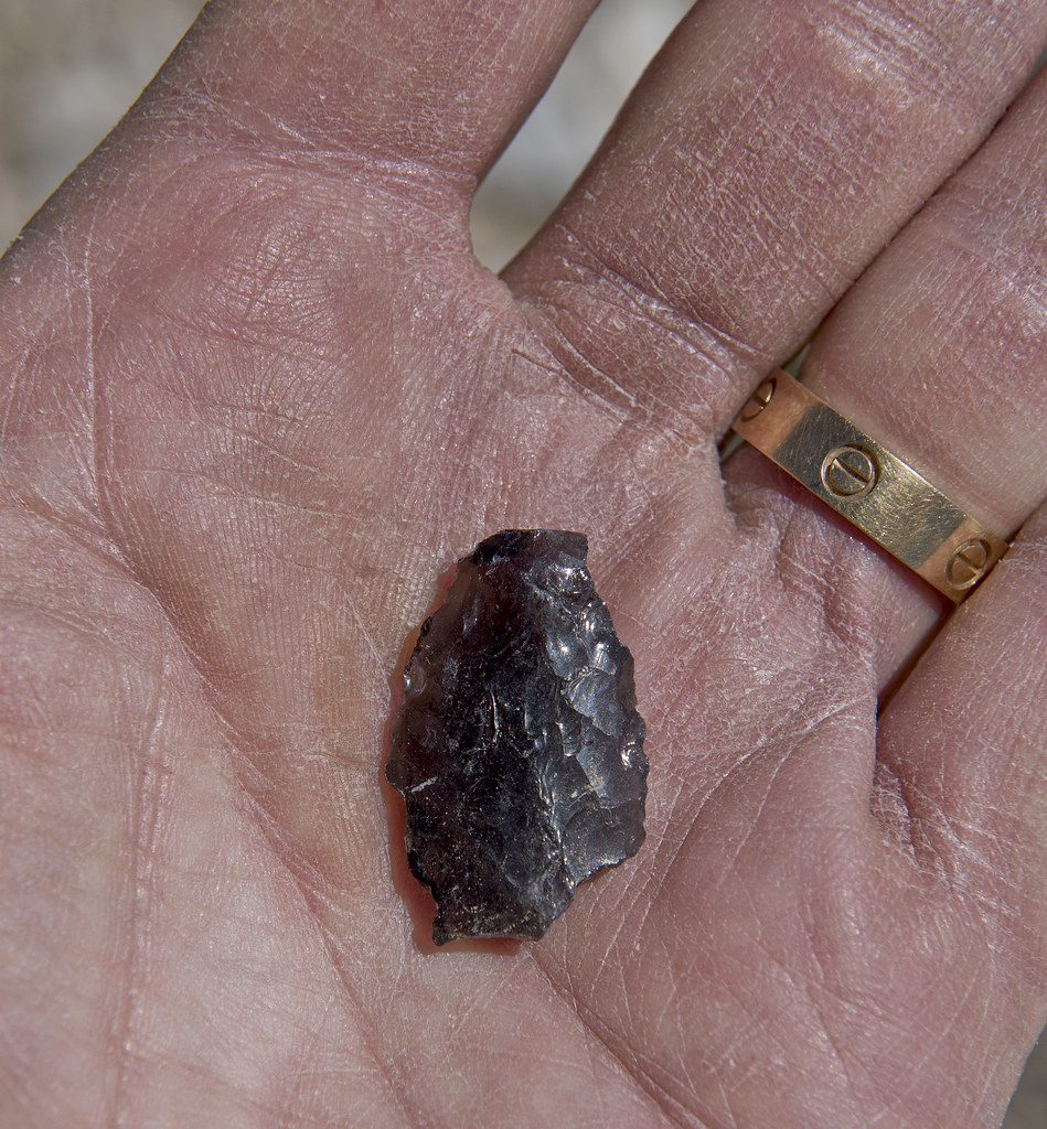
Walking back to the truck, found this really nice large projectile point with a broken tip and missing base. Probably the largest point I've ever seen and definitely atlatl/spear material.
 Ayers Rock Point by tomteske, on Flickr Ayers Rock Point by tomteske, on Flickr
We next headed up to the Bishop area. The heat kinda limited our activities but spent a relaxing evening near Buttermilk Boulders. Here's a rock art site associated with this area.
 Buttermilk Boulder Pano_lxx_0.36_0.78_1.02 by tomteske, on Flickr Buttermilk Boulder Pano_lxx_0.36_0.78_1.02 by tomteske, on Flickr
Went up Silver Canyon Rd toward the Ancient Bristlecone Pine Forest, a rather steep (4-Lo) route to the crest of the White Mts. Saw a ewe group of five ewes and two lambs. Not sure if that's a good or bad ratio of mommies to babies but you sheep counters would know. Almost felt like Buford with my camera a couple times since the sheep were pretty close to the road
 Ewe Group With Two Lambs by tomteske, on Flickr Ewe Group With Two Lambs by tomteske, on Flickr
 Ewe on the DL by tomteske, on Flickr Ewe on the DL by tomteske, on Flickr
 Silver Canyon Switchbacks by tomteske, on Flickr Silver Canyon Switchbacks by tomteske, on Flickr
Camped at a nice plateau at about 8300 ft but still in the 90s when we got there. The evenings were always cool and had a great view of the night sky and Milky Way.
 Silver Canyon Road by tomteske, on Flickr Silver Canyon Road by tomteske, on Flickr
Visited the Patriarch Grove.
 Patriarch Grove by tomteske, on Flickr Patriarch Grove by tomteske, on Flickr
 Patriarch Grove A Giraud by tomteske, on Flickr Patriarch Grove A Giraud by tomteske, on Flickr
Found a nice ?western stemmed point in the middle of the tundra.
 Great Basin Stemmed Point by tomteske, on Flickr Great Basin Stemmed Point by tomteske, on Flickr
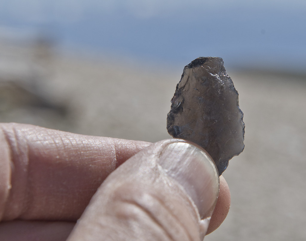 Great Basin Stemmed Point 3 by tomteske, on Flickr Great Basin Stemmed Point 3 by tomteske, on Flickr
Lots of nice little flowers in the tundra.
 Tundra Flowers by tomteske, on Flickr Tundra Flowers by tomteske, on Flickr
 Tundra Flowers 2 by tomteske, on Flickr Tundra Flowers 2 by tomteske, on Flickr
Hawk near a water trough.
 Hawk at Trough 2 by tomteske, on Flickr Hawk at Trough 2 by tomteske, on Flickr
 Hawk at Trough by tomteske, on Flickr Hawk at Trough by tomteske, on Flickr
Spent one night at Alabama Hills which is pretty, but.... Headed up to Whitney Portal for a mandatory water fall sighting per the spouse.
 IMG_4411 by tomteske, on Flickr IMG_4411 by tomteske, on Flickr
 IMG_4403 by tomteske, on Flickr IMG_4403 by tomteske, on Flickr
One last rock art site on the way home.
 Walker Creek Boulder_xp-0.25_1.52 by tomteske, on Flickr Walker Creek Boulder_xp-0.25_1.52 by tomteske, on Flickr
And probably the wife's favorite camping spot after five days in the heat Did hook her up with a new shower setup and awning which was greatly appreciated by all.
 IMG_4439 by tomteske, on Flickr IMG_4439 by tomteske, on Flickr
About 1K mlles driving, maybe a couple miles hiking and another great time in the outdoors. Enjoy! Tom |
7/14/2020
Topic:
Owens Valley
tommy750
|
Rocko1 wrote:
Very nice! I am always amazed at how you find these artifacts. You may have a built in dowsing rod ability for this stuff. 
That's exactly what I used to say to everyone I went out with when they found stuff and I never did. Then one day I was out in Canebrake with Daren and found seven points. Now, it seems easier to find stuff. Guess something in your brain clicks and then they're much more obvious to locate. |
7/15/2020
Topic:
Owens Valley
tommy750
|
rockhopper wrote:
Nice rock art expedition Tommy. The whole Owens valley was a major corridor to the early peoples for thousands of years so there is a lot of rock art out there. Speaking of thousands of years, that obsidian point you found on the White mountains is probably very very old. That has been a dry mountain for a long time with only seasonal creeks from snow melt. Was it found near a seasonal creek drainage? btw Years ago, when we went up to the Bristle cone forest / White mountains we smoke the clutch on our Ford Ranger going up the top locked gate just shy of the 14,000 ft+ summit weather station. I probably walked over your arrow point.
I found the point lying on the ground near where I took the BW bristlecone pic. Wasn't really near anything. Assuming the road to the research station used to be open?? Wow, that would have been a nice trip. Now the gate is at 11.7K and you've got a 15 mile 3K g/l hike ahead of you. I found out my Tundra had a transmission fluid temp idiot light going up Silver Canyon. Magically went away when I changed from 4-Hi to 4-Lo. Silver Canyon is the short cut from Bishop to the White Mts and is about a 6,200 feet climb in 9 miles with a 43% grade in places. Was about 100 degrees till above 8000 ft. Our camp site off the road had great views of the night sky but totally forgot about the comet. Need to check that out this weekend. |
7/15/2020
Topic:
Owens Valley
tommy750
|
ziphius wrote:
Great trip Tommy. Makes me miss the desert!
What are you waiting for Ziphius?? Everything is open and Inner Pasture this weekend is probably only as hot as El Cajon Mt. during an illicit August dayhike. |
7/17/2020
Topic:
Photography
tommy750
|
Nice pic! Was thinking of heading out tonight to take a peek. |
7/17/2020
Topic:
Owens Valley
tommy750
|
Buford wrote:
Nice report.
I like the sheep shots of course . Two lambs to five ewes is not terrible. ABDSP in July lamb survival is close to 0% some years and areas, other areas close to 70%. I don't know what normal is near the Bristlecones.
I have been meaning to make my way up to the White Mountains.
Thanks for the info. Couldn't find anything specific regarding sheep in that area but it's not endangered like the Sierra or Peninsular sheep and the forest service website mentions sighting in that area. |
7/18/2020
Topic:
Photography
tommy750
|
Here it is last night about 930 pm off EC 85 a few miles above Plaster City. Was windy and 90-95 degrees still so not the best conditions! You can see the faint second tail and the entire tail has swung rightward compared to Buford's earlier pic. Could easily see it with the naked eye out there but not in my front yard in El Centro even with binoculars. Was really cool to see.
 Neowise1 by tomteske, on Flickr Neowise1 by tomteske, on Flickr |
7/19/2020
Topic:
Photography
tommy750
|
Very nice time-lapse. |
7/27/2020
Topic:
Photography
tommy750
|
ziphius wrote:
Clouds rushing over San Ysidro Mtns from Big Spring area in 2014.
https://video.wixstatic.com/video/a56887_3e935c1a146c4aad98b3d4525a9296d5/1080p/mp4/file.mp4
Nice, I like it. Mind sharing your settings taking/making the clip? Thanks! |
8/2/2020
Topic:
Owens Valley
tommy750
|
tekewin wrote:
Thanks for report! It took me a few minutes to figure out that tent set up. Clever.
You got some close up sheep, always a treat. The White Mountains are still on my to-do list. I've heard the road is really long and rough.
All the dirt roads on top we traveled on were not bad and you could easily drive 30-40 mph. Not really sure about other seasons, however. |
8/2/2020
Topic:
Owens Valley
tommy750
|
dsefcik wrote:
Nice TR tommy750....Gary, myself and other gang members were not too far away up in the Domeland Wilderness and enjoyed some very hot summer weather as well. We did manage to see bears, deer and other local wildlife and some rock art. Glad you and the spouse had a good trip.
Definitely was warm out there. You guys probably had a nice portable shower at base camp like we did, right?? Looking forward to your post! |
8/17/2020
Topic:
Oriflame Mountain
tommy750
|
I seemed to have overlooked this nice TR, Rocko1. Davidwyby, thanks for bringing it to my attention! Surprised you found any cultural stuff out there just as Gary and I were surprised we found any thing the one time we were out there since BLM allowed the ranchers to plow/drag most of that plateau up there including a nice occupation site. Did you notice any water in Salt Creek or Oriflame Creek when you were out there? |
8/20/2020
Topic:
Valley of the Moon to East Davies Valley
tommy750
|
Have hiked out to Peak 4004 a few times along with Davies and Pinto but never that route. Looks like fun. Great TR. Thanks |
8/25/2020
Topic:
Valley of the Moon to East Davies Valley
tommy750
|
Spent about 45 minutes today talking with a BP agent regarding desert hiking and he said the wall was already being built in Davies Valley and possibly Valley of The Moon. Couldn't really believe this was happening but I was wrong. Here's satellite imaging from two days ago and four months ago. Have to admit, Davies Valley was one of the most serene and placid places I've ever hiked, but not anymore. Valley of The Moon doesn't look like it's been touched---yet.
 ezgif.com-gif-maker by tomteske, on Flickr ezgif.com-gif-maker by tomteske, on Flickr |
8/26/2020
Topic:
Valley of the Moon to East Davies Valley
tommy750
|
Heard BLM already towed them. Three? I only remember two, the blue Chevy Blazer and the grey/maroon ?Nissan. |
9/5/2020
Topic:
The Potrero
tommy750
|
Rocko1 wrote:
I didn't know there was a spring back there. Is it still viable?
I along with these froggies can attest it's quite viable as of a few weeks ago.
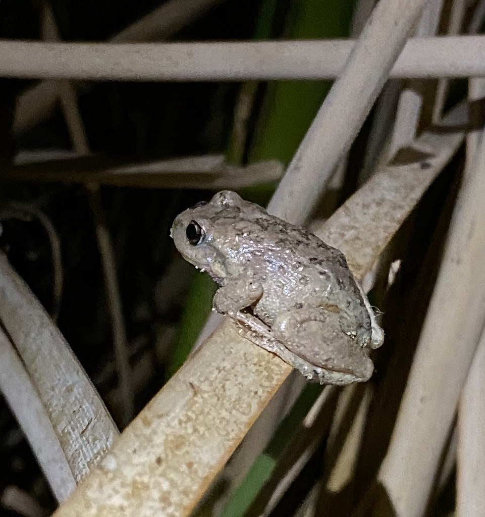 IMG_4602 by tomteske, on Flickr IMG_4602 by tomteske, on Flickr
 IMG_4627 by tomteske, on Flickr IMG_4627 by tomteske, on Flickr |
9/5/2020
Topic:
The Potrero
tommy750
|
sddarkman619 wrote:
Ziphius, the unwanted 4x4 traffic, were they stupid drunk people? Did they cause any issues? or did they leave?
Possibly taking my Daughter out for her first BP trip and hearing this makes me wonder if I should be concerned.
I know there's others on this forum who've been out in Potrero many more times than I have but during the dozen or so times I've been out there for day hikes and BP trips I've seen people three times, a couple people poking around a cultural site and two groups of hunters. Think it would be a great first backpacking trip choice.
edited by tommy750 on 9/5/2020 |
9/7/2020
Topic:
Valley of the Moon to East Davies Valley
tommy750
|
cercidium wrote:
thanks for posting these updates, especially the recent satellite view from tommy. was that from a service you subscribe to?
I got the images from caltopo.com. At the bottom of the drop down base layers menu there is a choice for "live satellites" but you have to be a pro member which is about $50/year. I use that site so often I'm happy to give them that amount yearly.
Thanks for the wall update, Cercidium. Looking forward to seeing you pics. |
9/10/2020
Topic:
Photography
tommy750
|
Very nice time lapse clips! |
10/7/2020
Topic:
Mason Valley Truck Trail
tommy750
|
Nice TR, Daren. Your trail register pic shows an entry listed in Peakbagger.com and that guy is apparently a pretty badass peakbagger: https://www.peakbagger.com/climber/climber.aspx?cid=711
You get a good view of the Lassater Hay Road just below the summit? |
10/8/2020
Topic:
The Killing of Frank Fox
tommy750
|
According to this, the grave washed away years ago: https://sandiegohistory.org/collection/davis/op-15362-25/
Would be nice to see if the plaque is still out there. Have been out there a few times but never found it. The OP below is the only article I've seen mentioning the black plaque. |
10/11/2020
Topic:
The Killing of Frank Fox
tommy750
|
Great detective work and great find, Britain! |
1/13/2021
Topic:
Death Valley Trip 12-2020
tommy750
|
Very nice, Daren. Pretty convinced one of you three has that rocket in your front yard right now |
1/14/2021
Topic:
Rabbit Hemorrhagic Disease
tommy750
|
Just an FYI about something you may have already heard about in the news. Was out hiking the past two weekends in the Dos Cabezas and Piedras Grandes area and encountered three deceased rabbits which is way more than I've ever seen just walking around before. Visited the Cal Fish and Wildlife site and noted they recommend reporting multiple rabbit deaths to aid in surveillance of Rabbit Hemorrhagic Disease. So I did right here: https://wildlife.ca.gov/Conservation/Laboratories/Wildlife-Investigations/Monitoring#55671861-rabbit-hemorrhagic-disease Got a nice call from Sacramento this afternoon from Kelsey, a cheery Fish and Wildlife rep interested in the find. Not sure what happens next but would suggest all of you desert hikers file similar reports if you encounter rabbit mortality since Kelsey seems to indicate the responsible virus is a bad actor and currently present in San Diego County.
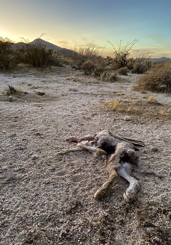 IMG_5683 by tomteske, on Flickr IMG_5683 by tomteske, on Flickr |
1/18/2021
Topic:
Rabbit Hemorrhagic Disease
tommy750
|
ziphius wrote:
Also bad news if you're a red-tailed hawk, bobcat, coyote....
Ziphius, did you mean no species barrier or less fresh meat? |
1/19/2021
Topic:
Rabbit Hemorrhagic Disease
tommy750
|
Rocko1 wrote:
ziphius wrote:
Also bad news if you're a red-tailed hawk, bobcat, coyote....
RHD isn't zoonotic and only affects rabbits.
Thank you for the clarification, Rocko1. |
1/19/2021
Topic:
Rabbit Hemorrhagic Disease
tommy750
|
ziphius wrote:
tommy750 wrote:
ziphius wrote:
Also bad news if you're a red-tailed hawk, bobcat, coyote....
Ziphius, did you mean no species barrier or less fresh meat?
Tommy, yes, I meant that rabbits are an extremely-important dietary item to those carnivores.
Thanks, Ziphius. Looking around the Fish and Wildlife site, just noted human carnivores have a year round jack rabbit open season as well. |
2/7/2021
Topic:
Martinez Canyon to Jack Miller cabin
tommy750
|
The only time I've ever drank green water was at Jack Miller Cabin having filtered the next day's supply at The Narrows just downstream. Was there any water running at Jack Miller? Great TR, Brian. |
2/7/2021
Topic:
Villager Peak
tommy750
|
That looks like a great trip. Happy to hear any tips you have on convincing my spousal "hiking partner" to bag Rabbit |
2/17/2021
Topic:
Canebrake Valley and The Santa Rosas
tommy750
|
Daren and Gary recently floated the idea of a 3-4 day trip to the crest of the Santa Rosas searching for the lost "Cave of The Seven Ollas," yet another magnificent tale, er, historical reality based on multiple anecdotal accounts. Using snow as a water source, a new area of interest would be searched and hopefully the mysterious cave relocated. In order to accommodate Randy and myself, the trip was delayed one relatively warm week with live satellite images showing a rapidly shrinking snow cover. As a warm up hike, Daren, his Marine buddy Yokes and I headed out to Canebrake for the weekend and descended the now literally Pepperwood Hiking and Dirt Bike Trail. Daren and Yokes decked out in camo spooked one group of riders but more were coming.
The faded picto panels in Pepperwood Canyon.
 Pepperwood Picto2 by tomteske, on Flickr Pepperwood Picto2 by tomteske, on Flickr
 Pepperwood Picto by tomteske, on Flickr Pepperwood Picto by tomteske, on Flickr
Daren and Yokes checking out a potential water source.
 Canebrake by tomteske, on Flickr Canebrake by tomteske, on Flickr
A nice incised pottery sherd and two Cottonwood points at a site overlooking the valley we all explored.
 IMG_5909 by tomteske, on Flickr IMG_5909 by tomteske, on Flickr
 IMG_5911 by tomteske, on Flickr IMG_5911 by tomteske, on Flickr
Another bunny.
 IMG_5907 by tomteske, on Flickr IMG_5907 by tomteske, on Flickr
Camped near an old spring and "trough" but the spring was only a wet spot even after the recent rains.
 IMG_5923 by tomteske, on Flickr IMG_5923 by tomteske, on Flickr
 IMG_5924 by tomteske, on Flickr IMG_5924 by tomteske, on Flickr
Marker pole on a hill overlooking the valley.
 IMG_5928 by tomteske, on Flickr IMG_5928 by tomteske, on Flickr
Had to filter water on the way out at Pepperwood Spring. That's Daren searching for the chlorine tabs to blunt the rich organic taste.
 IMG_5936 by tomteske, on Flickr IMG_5936 by tomteske, on Flickr
During the night, a kitty must have ascended the same trail we used. My boot for scale.
 IMG_5937 by tomteske, on Flickr IMG_5937 by tomteske, on Flickr
We met up the next weekend for the Santa Rosas hike. Parked our vehicles at the base of Coyote Mt. Was winding and rainy at the start but ended up a nice day. Old vehicles at an old homestead.
 IMG_5960 by tomteske, on Flickr IMG_5960 by tomteske, on Flickr
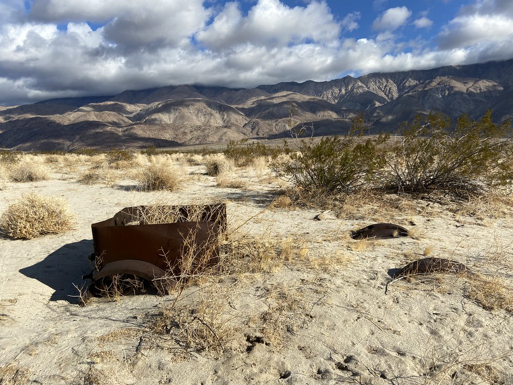 IMG_5964 by tomteske, on Flickr IMG_5964 by tomteske, on Flickr
Nice view with about 2K left to climb.
 IMG_5969 by tomteske, on Flickr IMG_5969 by tomteske, on Flickr
Interesting village site with lots of rock circles and pottery sherds.
 IMG_5973 by tomteske, on Flickr IMG_5973 by tomteske, on Flickr
Painted sherds are always nice to find. These were actually painted on the inside and outside.
 Painted Sherd by tomteske, on Flickr Painted Sherd by tomteske, on Flickr
 Painted Rim Sherd1 by tomteske, on Flickr Painted Rim Sherd1 by tomteske, on Flickr
We made it to the ridge about half way between Dawns and Rabbit a little after 5 pm, a 5K climb from Clark Lake. Gary and Randy decided to camp lower down. Nice cool evening with great views of all the glimmering lights from the night sky and Ocotillo Wells...
The next morning before I got up, Daren search high and low for snow and found a tiny patch in about three miles of hiking. Since I was the lowest on water, I dutifully boiled it, filtered out the dirt and twigs and had yet another refreshing naturally flavored liter on the way down (tasted like Negroni if that's something you have tucked away in your liquor cabinet).
 IMG_5989 by tomteske, on Flickr IMG_5989 by tomteske, on Flickr
About 18 miles, 5300 ft g/l and maybe ten mylars. Enjoy!
 Santa Rosas From Clark by tomteske, on Flickr Santa Rosas From Clark by tomteske, on Flickr |
2/17/2021
Topic:
Pyramid, Rosa Pt., Mile High Loop
tommy750
|
Another great TR, Ziphius. Great pics. Hand drawn maps?? Suppose your gps is the "backup" to your compass? Really nice. |
2/17/2021
Topic:
Canebrake Valley and The Santa Rosas
tommy750
|
ziphius wrote:
Good-looking trips Tommy. Nice lion track, looks like a right hind. That painted pottery shard is really nice. I've been regaled with the story of the Cave of The Seven Ollas by Gary while counting sheep with him. Hope you guys find it one day and never tell a soul. That's a lot of camo!
I have about a dozen possible points on GE for the cave AKA CSO scattered all over the Santa Rosas, many provided by others. Gary sends out an article every once in a while and I try to make sense of it but every account is very different. Still fun searching.
Yeah, lots of camo these days. Gary, Randy, Daren and Yokes. I'm still trying to stick with solids |
2/17/2021
Topic:
Canebrake Valley and The Santa Rosas
tommy750
|
Brian wrote:
Is the Pepperwood Hiking and Dirt Bike Trail the one that starts in Cottonwood Campground? I haven't hiked it in years, but I remember it being too steep and slippery for a bike. Is it an official route for bikes now or was the group using it illegally?
The Pepperwood trail is off limits to motorcycles but I have seen occasional tracks over the past five years. The last hike out was the worst. Someone even seems to be trimming the brush to widen the trail. I usually start at the end of McCain Valley Rd and drift NE to the start but you can easily get there from the campground. |
2/17/2021
Topic:
Canebrake Valley and The Santa Rosas
tommy750
|
tekewin wrote:
That was quite a hike up to the ridge! I'm not familiar the Cave story, will Google.
Very impressive painted pottery shard. I'm usually not looking for them when I'm out, but should be. I can't imagine how hard it must have been to live on this land.
Was definitely a good climb up there. Rarely find painted pottery and even less common to see the incised ones but definitely a neat find. |
2/17/2021
Topic:
Canebrake Valley and The Santa Rosas
tommy750
|
Rocko1 wrote:
Fantastic finds! One question Tommy, how was the accent in the Santa Rosas(especially the last stretch to the saddle)? Was there much rock scrambling?
There was a little slip and slide from some sandy areas near the top but not too bad and nothing over Class 2. On occasion, you could imagine an old trail and there was pottery scattered all the way to the top. |
2/17/2021
Topic:
Canebrake Valley and The Santa Rosas
tommy750
|
Buford wrote:
Excellent stone points!
I too have heard Gary explain his quest to find the cave with the ollas.
That is tough work hauling overnight gear up to the Santa Rosa ridgeline. I am surprised there was any snow still up there on the dates of your trip. A couple days before your trip I was on the ridgeline and there was very little snow even above 6k. We also started at the base of Coyote Mountain but took different routes than your map.
Yeah, carrying the extra 25-30-ish lbs to the top does add to the "fun." Buford, you brought water for the entire trip or used snow? |
2/18/2021
Topic:
Canebrake Valley and The Santa Rosas
tommy750
|
Rocko1 wrote:
Tommy, how far from the saddle did you camp? Looked like a couple of nice flat areas for that in the pics.
You can see where we camped on the gps route. It was right at the cliff edge on the west side of the ridge since the winds were howling on the east side. |
2/21/2021
Topic:
Rabbit Hemorrhagic Disease
tommy750
|
DesertWRX wrote:
Found 4 dead cottontails on our property recently. Hopefully it is the virus and not a neighbor poisoning them.
Did you report them to Fish and Wildlife? The link is above if you want to. |
3/1/2021
Topic:
Rabbit Hemorrhagic Disease
tommy750
|
Just got back from a three day BP trip with Daren through Inner Pasture and Potrero. We encountered ten rabbit carcasses. Saw a few live bunnies but not the usual bunny every hour or so all day long. We found another carcass in Canebrake a couple weeks ago. We were led to some carcasses by crows and suspect this predator (and others) is how the disease (assuming this is RHDV2) would be able to spread the 16 miles "as the crow flies" from the first sighting near Piedras Grandes to IP/Potrero. Was rather disappointing to see all the carnage. Will report this to Fish and Wildlife. |
3/23/2021
Topic:
Helicopter on Jacumba Gas Station?
tommy750
|
When I saw the Chevron station put up the chopper I assumed it was a way to drum up business since the Shell station competitor always had way more customers. Your link clarified everything. Thanks! |
3/23/2021
Topic:
Election Week 2020 Hiding In The Desert
tommy750
|
Just stumbled on your post, Ziphius. Very informative TR and an even better use of time than watching Steve Kornacki fret about when to call Arizona. Daren and I were out in Potrero late February and noted a lot of stripped cholla. Packrats?? Thanks! |
4/13/2021
Topic:
Rabbit Peak Overnight
tommy750
|
Just thinking about 9L x 2.2lbs/L= makes me hit the wall Great TR and really like your pano pic above the selfie. Okay, the selfie is nice, too... |
4/19/2021
Topic:
Three days of Petroglyphs in the Santa Rosas
tommy750
|
Very nice TR, Rockhopper. Lot of really old looking petros! Need to get out there. |
6/6/2021
Topic:
Carrizo Gorge 3 Day Backpack
tommy750
|
ziphius wrote:
Water quality sounds fun..... pretty sure your dead critter is a gray fox.
So Ziphius, while you're on the subject, what do you think about this dead guy in Potrero from a couple months back?
 IMG_6411 by tomteske, on Flickr IMG_6411 by tomteske, on Flickr
 IMG_6418 by tomteske, on Flickr IMG_6418 by tomteske, on Flickr |
6/6/2021
Topic:
Carrizo Gorge 3 Day Backpack
tommy750
|
Nice TR, Daren. Was wondering how you guys were going to manage your water with 90+ degree heat. Time for an activated charcoal filter downstream from the Sawyer. |
6/20/2021
Topic:
Fire in Upper Canebrake Canyon
tommy750
|
Caltopo has a couple nice map overlays that help show what's going on with active fires. Here's a link centered on the Overland Fire: https://caltopo.com/m/GLS2 You may need to zoom out.
The aqua, terra and viirs labels are satellite names. Looks like the 20-30 mph west wind is driving it down the valley.
edited by tommy750 on 6/20/2021 |
7/4/2021
Topic:
North McCain Valley
tommy750
|
Watched a work-mandated OSHA heat exposure video last week so figured I was ready for summer hiking. "Rest, Shade, Water", it advised. Headed out to McCain Valley where it was 86 when I arrived at 9 am (forecast said high of 83). Occasional nice shady spot:
 IMG_6767 by tomteske, on Flickr IMG_6767 by tomteske, on Flickr
Found this little guy inside. Looks like a striped racer.(7/20/21 Correction: going to have to change my mind on that; looks more like at Coast Patchnose; you can check here for more info: http://www.californiaherps.com/snakes/pages/s.h.virgultea.html ) It waited till I got a few pics and zipped away. Saw/heard one other snake but it rattled and zipped away before a pic.
 IMG_6762 by tomteske, on Flickr IMG_6762 by tomteske, on Flickr
Came across a couple nice rock shelters with flakes and sherds near a village site overlooking Pepperwood Canyon:
 IMG_6780 by tomteske, on Flickr IMG_6780 by tomteske, on Flickr
Uniface stone tool:
 IMG_6774 by tomteske, on Flickr IMG_6774 by tomteske, on Flickr
This poor little guy was deep in a rock shelter:
 IMG_6755 by tomteske, on Flickr IMG_6755 by tomteske, on Flickr
Was going to head father north but only had 3L and some areas felt 95-100 degrees (was 93 degrees when I got back) so made it to a ridge overlooking Canebrake to take a peek at what the Overland Fire had done and turned back. You can see the red streaks where the fire retardant was dropped. Overall, didn't look too torn up at least from my vantage point.
 IMG_6804 by tomteske, on Flickr IMG_6804 by tomteske, on Flickr
About six miles and another nice day out hiking. Happy 4th. Tom
edited by tommy750 on 7/20/2021 |
7/5/2021
Topic:
North McCain Valley
tommy750
|
Brian wrote:
Great pics. Now you're tempting me to do some high desert stuff. I've been concentrating on El Cajon MTN and other local hikes to try to get in shape for next desert season.
El Cajon is a hard to beat place to prepare for any kind of hiking IMHO. Worst heat exposure experience I've ever had was attempting to climb El Cajon in August with 2L years ago. If only I'd seen the OSHA video! |
7/5/2021
Topic:
North McCain Valley
tommy750
|
ziphius wrote:
Nice trip report Tommy. Good time of year to be out there when prepared.
Yep, definitely had the place to myself. |
7/6/2021
Topic:
North McCain Valley
tommy750
|
rockhopper wrote:
Nice Trip. Looks like a juvenile cat. Too bad. Cougar? Bob cat? Definitely heading to higher elevations or close to the coast for the summer.
I am guessing it was bobcat based on its size and where it was found. Ziphius, any thoughts? |
7/6/2021
Topic:
North McCain Valley
tommy750
|
Rocko1 wrote:
Nice report. I have often found boulder caves in AB and other areas and thought-how did someone NOT occupy this as a shelter-seems more than likely someone did at some point in history.
RE: El Cajon Mtn-just did this yesterday with a 5:20am start. Even with the temps not that high, the humidity, lack of wind and near constant exposure coupled with some laughably steep climbs, it's a tough one! I would say it's harder than Granite's southwest approach.
Agree and agree. |
7/29/2021
Topic:
North McCain Valley
tommy750
|
A few years back I showed up in McCain for a mid summer overnight trip with Daren while wearing all white including a big floppy hat. As I recall, the ensemble went over like a lead mylar as did prior discussions about a reflective hiking umbrella. Never got one but still think it would be a good idea in low wind open terrain. Don't forget the SPF part. Have already had my share of skin cancers removed and total body coverage with something, sunscreen or clothing, is a good idea. |
9/10/2021
Topic:
Haboob in Borrego Springs
tommy750
|
Very nice TR, Ziphius. My wife and I just found out the hard way what "Chubasco" meant a few nights ago down in Baja camping in a tent. |
9/16/2021
Topic:
Chubascos, Bees and Coyotes
tommy750
|
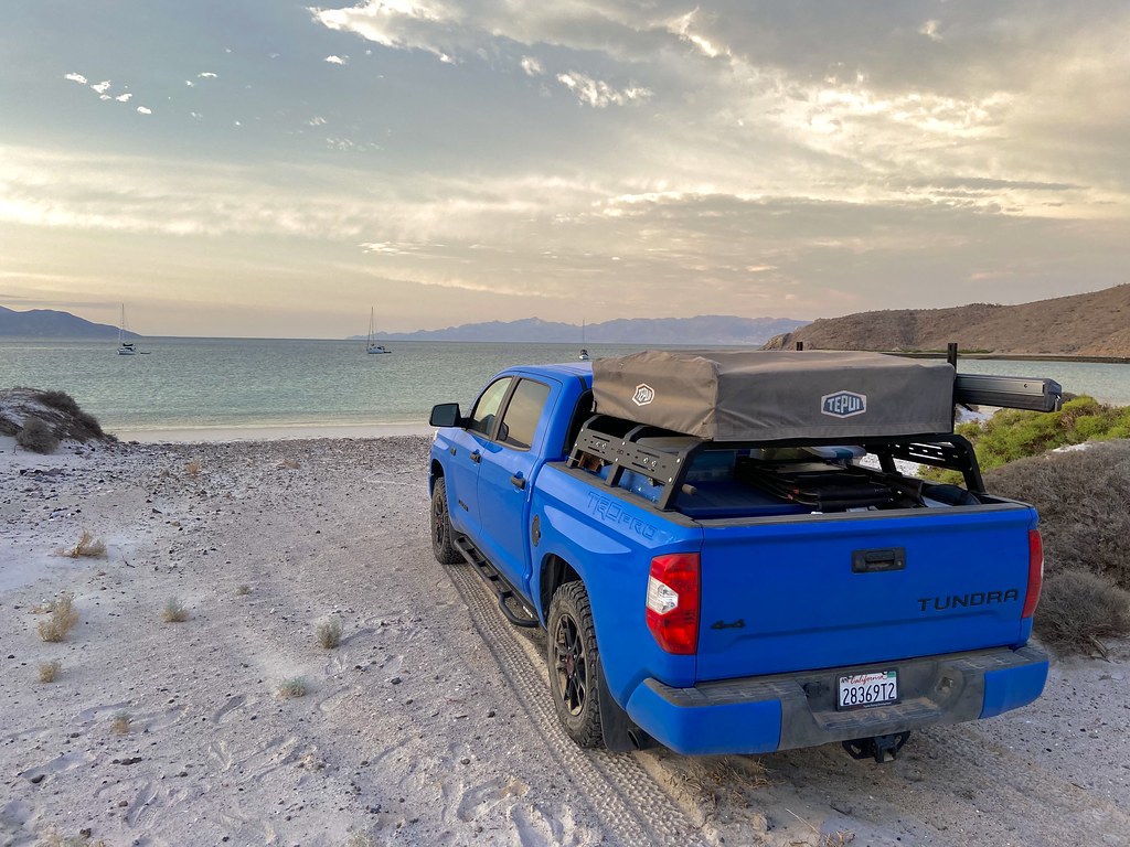
Not exactly The Park but kinda the same idea. My wife and I decided to head down to Baja last week for a break. Found a nice beach on GE we'd never visited and figured what the heck. Took about eight hours driving and arrived at the end of a 30 mile dirt road to this scene. Never would have guessed there would be five sailboats anchored off shore. Most of the sailors showed up on shore for a bonfire that night. There were retirees and two younger couples who had been sailing the Gulf for the past 1-2 years. Was a rather stark contrast to the standard rat race (guilty) and felt more than a twinge of envy regarding their circumstances. Before we left to set up camp, they mentioned Chubascos, bees and coyotes and we would find out exactly what they meant.
 IMG_7065 by tomteske, on Flickr IMG_7065 by tomteske, on Flickr
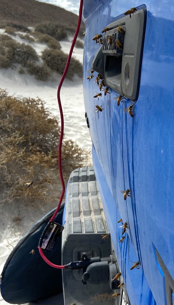
The next morning, we awakened to a beepocalypse. Hundreds of bees swarmed the water container on the tailgate and any stray moisture that may have leaked during the trip. Being a bit rusty regarding bee mitigation strategies and no internet, I was unable to make any inroads before my wife crawled out the tent and was promptly stung (ended up being three times total). With a concerted effort to relocate all our water jugs away from camp, immediately bury any spilled liquids and judicious use of DEET, we were able to make some inroads but our camp coordinates were firmly imprinted on too many bees to not have an ongoing problem. The pics don't capture even a slight percentage of the swarm.
 IMG_7075 by tomteske, on Flickr IMG_7075 by tomteske, on Flickr
 IMG_7072 by tomteske, on Flickr IMG_7072 by tomteske, on Flickr
We were able to improve the mood a bit with a few beverages and a dip in the 85 degree water. My wife is trying to finish some continuing education requirements.
 IMG_7080 by tomteske, on Flickr IMG_7080 by tomteske, on Flickr
Definitely were coyotes all over the beach which is rather common down there. Did notice both my water jugs got chewed up quite a bit.
 IMG_7070 by tomteske, on Flickr IMG_7070 by tomteske, on Flickr
 Low Tide Coyotes by tomteske, on Flickr Low Tide Coyotes by tomteske, on Flickr
 Lone Coyote by tomteske, on Flickr Lone Coyote by tomteske, on Flickr
 IMG_7118 by tomteske, on Flickr IMG_7118 by tomteske, on Flickr
Oh yeah, the Chubascos. The first night there was lots of lightening to the south and some wind but nothing major. The third night we awakened to strong gusts but regrettably delayed securing camp till things got dramatic. By the time we got serious, our "well secured" staked and guylined awning was flailing in the wind and bashing the truck. Fortunately, there was no significant damage. While blasted by blowing sand, we furiously threw every loose item into the truck bed, collapsed the roof top tent and jumped into the truck for the subsequent hour long deluge. By the next morning, the wife was pretty much over our relaxing stay on a deserted beach and we broke camp. The place is obviously quite beautiful but just not ideal in mid-September. Was also a speck on the warm side...
 IMG_7071 by tomteske, on Flickr IMG_7071 by tomteske, on Flickr
 Playa by tomteske, on Flickr Playa by tomteske, on Flickr
 Camp by tomteske, on Flickr Camp by tomteske, on Flickr
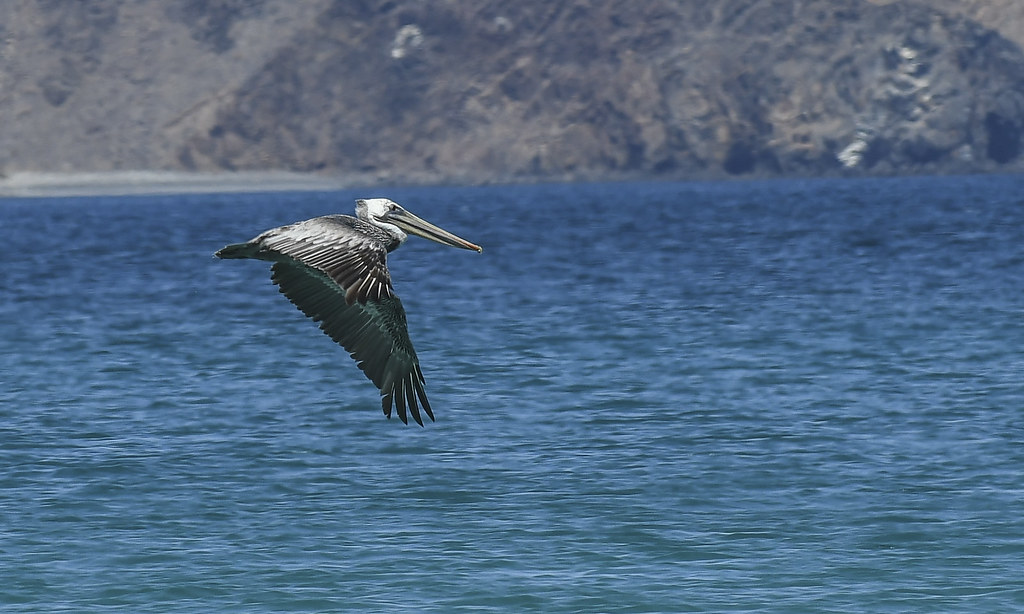 Pelican by tomteske, on Flickr Pelican by tomteske, on Flickr
 Bird by tomteske, on Flickr Bird by tomteske, on Flickr
 Beach Gull by tomteske, on Flickr Beach Gull by tomteske, on Flickr
Leaving camp.
 IMG_7092 by tomteske, on Flickr IMG_7092 by tomteske, on Flickr
On the way out, spotted what I think were a ewe and lamb. They were rather shy.
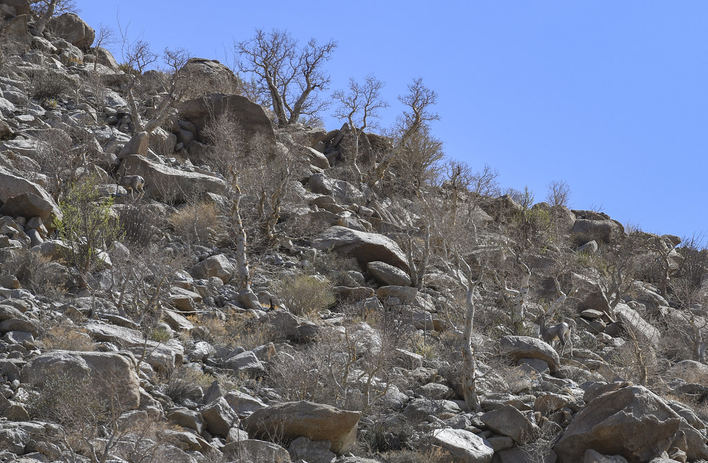 BHS Pair by tomteske, on Flickr BHS Pair by tomteske, on Flickr
 Bighorn Sheep Pair by tomteske, on Flickr Bighorn Sheep Pair by tomteske, on Flickr
Lots of elephant trees.
 IMG_7097 by tomteske, on Flickr IMG_7097 by tomteske, on Flickr
Few other critters.
 Raptor by tomteske, on Flickr Raptor by tomteske, on Flickr
 Horned Toad by tomteske, on Flickr Horned Toad by tomteske, on Flickr
Almost back to pavement. Was a very memorable trip with a "few" hiccups( forgot to mention the truck battery dying running the wife's shower setup---was able to luckily get it started using a Li battery jump start. Yeah, that was a rookie mistake) Definitely will be back. Enjoy! Tom
 IMG_7099 by tomteske, on Flickr IMG_7099 by tomteske, on Flickr |
9/17/2021
Topic:
Chubascos, Bees and Coyotes
tommy750
|
Rocko1 wrote:
Fantastic! Now that is a trip! It's so ironic to have that much beautiful water and not be able to drink it. I imagine there are no fresh water sources for many many miles?
edited by Rocko1 on 9/17/2021
Other than the back of my pickup? Probably not |
9/17/2021
Topic:
Chubascos, Bees and Coyotes
tommy750
|
Brian wrote:
I remember when the beach at Cabo looked like that and I remember thinking "it won't be like this for long."
Nice rig!
Did a number of trips to Baja in the late 70s and early 80s and when I first returned in 2011 I couldn't believe how all the pristine beaches were covered with houses or fenced in with a guy wanting $5 for the day. The one exception was Bahia de Las Animas south of LA Bay and maybe the beach we just stayed at. Both, a little off the beaten path. |
9/17/2021
Topic:
Chubascos, Bees and Coyotes
tommy750
|
Britain wrote:
Thanks for sharing. Love the Baja. I like taking the dirt roads south at the Rumerosa. Lots of good camping hiking areas. Head on down to Mikes Sky ranch and then either go down the pacific side or the gulf side. Travel Baja use to sell gps maps. I have an older version but at that time it did a good job showing dirt roads and places to get gas.
The classic Baja California Almanac and Nat Geo maps are pretty dated but there's a new Baja atlas here: https://smile.amazon.com/Baja-California-Recreation-Atlas-Benchmark/dp/1734315059/ref=sr_1_3?crid=3GBS8PJRUUJ3P&dchild=1&keywords=baja+california+atlas+2021&qid=1631936640&sprefix=baja+california+atlas%2Caps%2C210&sr=8-3
There's an app called Map E32 with a decent topos of Baja but in order to be useful you have to get the pro edition for $60 and then download tiles for wherever you're going. Mexico has great free topos of all of Baja but the only place I could find them stitched together was surprisingly caltopo.com---for free.
Need to check out the roads south of La Rumorosa. |
9/17/2021
Topic:
Chubascos, Bees and Coyotes
tommy750
|
Buford wrote:
Nice trip report. The only thing missing for a full Baja beach experience is noseeums.
Buford, you're a truly experienced Baja Traveler! My wife took a nap on the beach and got obliterated by noseeums or sand fleas or whatever they are. We were searching farmacias on the way back for creams etc. Read her your post and she started laughing. |
9/19/2021
Topic:
Chubascos, Bees and Coyotes
tommy750
|
ziphius wrote:
Great trip report Tommy. Love the coyote tracks, and even the coyotes! Spent a lot of time in 1997 in the northern Gulf on research vessels, surveying for the elusive vaquita porpoise. Saw a few too. The sheep know where the tinajas are...
So, you were involved in the first survey of the vaquitas in 1997? Are there any still alive?? Outlook seems quite desperate. |
9/21/2021
Topic:
Chubascos, Bees and Coyotes
tommy750
|
tekewin wrote:
What a wild trip! Assaulted by all kinds of wild life on the beach. Love the truck BTW. It looks loaded and ready for anything.
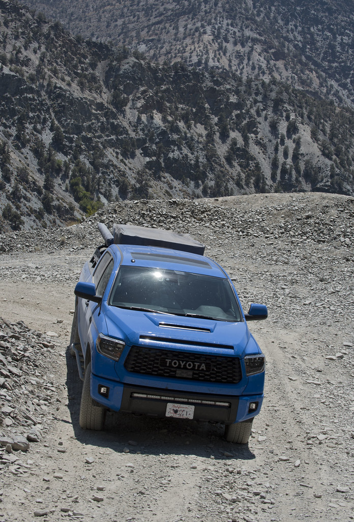
Took a stock Tundra and added KO2s, rock sliders, gas tank skid plate, a low bed rack for the lightweight RTT that's nearly below the roofline and a lightweight awning with adjustable height to keep it low while driving. No lifts, no racks on the cab or heavy stuff up high---all that makes me nervous driving on winding narrow roads. Saw lots of top heaving vehicles that looked roll over ready. |
9/22/2021
Topic:
Chubascos, Bees and Coyotes
tommy750
|
rockhopper wrote:
Neat Baja trip. Is that Isla angel de la Guardia in the back ground on pic 1 ? Reminds me of trips down to Bay of LA and Mulege'. Never had the bee problem. It's been years. brings back great memories of Baja. Baja is longer than the boot of Italy!
Believe you're correct. Had a hard time figuring what islands were offshore till the stars came out and I realized my orientation was way off. The sky was so dark you could actually see Andromeda with the naked eye. |
9/22/2021
Topic:
Chubascos, Bees and Coyotes
tommy750
|
Rocko1 wrote:
Any worry of pirates down there?
Was thinking of the Gulf of Mexico where there's lots of piracy but just saw this: https://maritime-executive.com/article/sea-shepherd-vessel-attacked-again-in-gulf-of-california
Kinda disappointing. Ziphius, you have any info on these attacks? |
9/22/2021
Topic:
Chubascos, Bees and Coyotes
tommy750
|
dsefcik wrote:
Nice TR tommy750..!!
I like the pics, good eye spotting the BHS....
Daren, if you ever find any free time in your extremely busy schedule, let me know and let's plan on a Baja adventure! |
9/24/2021
Topic:
Chubascos, Bees and Coyotes
tommy750
|
ziphius wrote:
tommy750 wrote:
Rocko1 wrote:
Any worry of pirates down there?
Was thinking of the Gulf of Mexico where there's lots of piracy but just saw this: https://maritime-executive.com/article/sea-shepherd-vessel-attacked-again-in-gulf-of-california
Kinda disappointing. Ziphius, you have any info on these attacks?
There's a lot of economic incentive to keep fishing, no matter what the consequences are for vaquita. So conservation groups being targeted is not a surprise. This article tells more of the story: https://qz.com/468358/how-chinas-fish-bladder-investment-craze-is-wiping-out-species-on-the-other-side-of-the-planet/
Interesting read. Thanks, Ziphius. When my wife and I were down in Baja in 2016 ( http://www.anzaborrego.net/anzaborrego/forum/topic1228-bahia-de-los-angeles-road-trip.aspx ), we encountered a couple fishermen who were harvesting the Blue Spotted Jawfish ( https://www.nationalgeographic.org/projects/photo-ark/animal/opistognathus-rosenblatti/ ). This trip, we saw multiple pangas near shore with diving hookah setups and presumably harvesting the same fish from their colonies on sandy bottoms. The two fishermen we met last trip stated they got $2.50 each and the price now on aquarium sites is around $200 each. Fortunately, they don't seen to be endangered---yet. |
11/22/2021
Topic:
Surf1div1 intro
tommy750
|
Hi Surf1Div1, have been to Pinto Canyon a couple times and it's well worth the trip. Things have changed quite a bit since my last trip with multiple new Border Patrol dirt roads heading to the canyon from Myer and Davies Valleys. It's (or was) wilderness so you'll need to walk. Should be multiple posts on this forum about Pinto Canyon. Have fun. |
11/22/2021
Topic:
Forum issues
tommy750
|
Thanks, Bob! |
11/22/2021
Topic:
M. Miller's Boots
tommy750
|
On the highest point in this pic is a boulder pile overlooking the Elephant Tree Area. Yesterday, I was out following one of the various Kumeyaay trails in the area and eventually ended up at said rock pile.
 Elephant Tree Area by tomteske, on Flickr Elephant Tree Area by tomteske, on Flickr
The pile contained a very nice rock shelter with rock circles both inside and out and multiple nearby roasting pits.
 IMG_7696 (1) by tomteske, on Flickr IMG_7696 (1) by tomteske, on Flickr
Inside the interior rock circle was a historical surprise.
 Boots by tomteske, on Flickr Boots by tomteske, on Flickr
Anyone seen this before or know who this person is?? Now, I too really liked my last pair of hiking boots but this seems more in the infatuation/obsession range Wasn't quite sure what the numbers were but figured out they are elevations with 5756 being Villager and 14495 being the old Whitney elevation. Assuming all the others could be figured out as well. Did a reverse image search but zero hits. Enjoy! Tom
 Plaque by tomteske, on Flickr Plaque by tomteske, on Flickr |
11/22/2021
Topic:
Rockhouse 3 day
tommy750
|
dsefcik wrote:
Gary and I did 8 days out there
Who has eight days to do Rockhouse? You guys freakin retired or something?? |
11/23/2021
Topic:
M. Miller's Boots
tommy750
|
Brian wrote:
Very cool find. Did you start out from the Elephant Tree area, or Hapaha Flat?
I started out from Fish Creek. There's supposedly a trail from Elephant Tree area to Harper/Hapaha but haven't found anything definite on GE as of yet. |
11/23/2021
Topic:
M. Miller's Boots
tommy750
|
Rocko1 wrote:
Wow, now that is interesting. Summit elevations listed-
CA-Villager 5,756' and Mt. Whitney 14,495'
OR-Mt. Hood 11,235'
WA-Mt. St. Helens 8,363'
NV-Wheeler Peak 13,063'
CO-Quandary Peak 14,265'
HI-Mauna Kea Volcano 13,796'
Africa-Kilimanjaro 19,340'
New Zealand-Couldn't find this one.
Is it just a memorial for the boots or boots and the person? I couldn't find any obituary's for a M Miller in 2012 in the San Diego area.
edited by Rocko1 on 11/23/2021
Thanks for doing the math, Rocko1!
I'm assuming the guy retired his 1984-2010 boots after an insanely long use period of 26 years (maybe special occasion only boots??) and in 2012 at age 59, hiked up to this shelter and left them as a memorial. The guy would now be 68 y/o and with all that peak bagging may be very much alive. Found an M. Miller living in Borrego Springs but have no idea if it's that guy. We've all found the RIP memorials for persons and pets out there but, your boots?? But heck, why not? |
11/23/2021
Topic:
Surf1div1 intro
tommy750
|
Wow, just checked out GE's updated Davies Valley imaging. They put a freeway through it! Have to admit, it was one of the most serene and peaceful places I've ever hiked but not anymore. Here's what it doesn't look like now from near BM Kirk toward the Sierra Juarez. If anyone wants to head out there for a day hike, would be happy to join you. Parking on old Hwy 80 and crossing under I-8, heading up Boulder/Myer, it's probably in the 14 mile range rt with Davies a few miles more but obviously easier since you can walk the freeway. Nothing is harder than a little boulder hopping.
 South Davies Valley3 by tomteske, on Flickr South Davies Valley3 by tomteske, on Flickr |
1/28/2022
Topic:
Is it just me or is there something not right?
tommy750
|
As someone rather skilled at getting lost, I'm giving this older guy from out of country a little slack. It was a mid week hike and there may have not been anyone around. Sounds like he let someone know where he was going and when he would be back. Obviously he should have prepared a speck better but at least he had the sense to stay alive out there for a couple days till found.
 Goat Canyon by tomteske, on Flickr Goat Canyon by tomteske, on Flickr |
2/6/2022
Topic:
Oasis Peak
tommy750
|
Nice trip and nice shelter find. Guess there's more to JT that Jumbo Rocks! |
2/16/2022
Topic:
Ghost Mtn, Shake BM and 3899
tommy750
|
Schad: "Resist the temptation to continue toward Little Blair Valley by going north of peak 3777---you won't save time this way."
Rocko1: Nah, let's do it!
Nice TR. Thanks.
edited by tommy750 on 2/16/2022 |
2/16/2022
Topic:
Whale Peak Overnight
tommy750
|
Nice trip and pics. Looks like the metal sign is holding up better than the previous wooden one. A route up Whale I kinda enjoyed started at Pinyon Wash, crossed Harper Flat and ascended a drainage out of Pinyon Canyon to the top. The only overnight I've ever done was up Smuggler and then at the top of the canyon making a turn south and following the 4600-4800 contours to a couple small meadows and then around to the summit. |
2/25/2022
Topic:
Snow
tommy750
|
Here's yesterday's satellite photos of Whale, Granite and the Santa Rosas. Looks like a good dusting on all of them.
 Whale and Granite by tomteske, on Flickr Whale and Granite by tomteske, on Flickr
 SANTA ROSAS by tomteske, on Flickr SANTA ROSAS by tomteske, on Flickr |
2/28/2022
Topic:
Snow
tommy750
|
Rocko1 wrote:
That's even better! Where would one find these images?
caltopo.com is where I got them but you need the pro subscription at $50/year to unlock the live satellite imaging. Happy to spend that amount for a super useful site and its free app which I use very frequently.
https://caltopo.com/subscription/update is ready to take your money! |
3/1/2022
Topic:
Snow
tommy750
|
rockhopper wrote:
Excellent! Rocko: I was thinking the same thing! Tommy750: Great photos. Thanks for sharing. What is the resolution on Cal topo? Is it high enough to see smallish features? Trails, small boulders, etc. G.Earth has resolution on some of it's images where you could see a football on the ground.
So, caltopo uses relatively low resolution for their live satellite and non-subscription "global imagery" layers. Their standard satellite imagery is GE but with a limit on zoom and no pan/tilt or rewind features. I always map and explore with both programs open. The most helpful layers for me on caltopo are public lands, fire history, historic topos and scanned topos. My current favorite GE imaging is from 10/2016 with the sun low in the sky and lots of nice shadows that make trails, rock circles and V shaped fish traps (a recent project) really pop. |
4/6/2022
Topic:
Camera found in Santa Rosas- Update
tommy750
|
The Canon PowerShot SX150 came out in 8/2011 so it could have been up there a while. Hopefully you can view the pics. |
4/7/2022
Topic:
Martinez and Agua Alta 3 Day backpack
tommy750
|
Glad to see someone else likes to spot stuff on GE and go out and find it. Did 9 miles this past weekend in order to get to this "rock" circle in an area known to contain Archaic sites via "Indian"/game/immigrant trails I also spotted on GE. Ended up being a lovely circle of cholla cacti around a sediment catchment and the trails had discarded plastic and clothing but still had a good time.
 Cholla Circle by tomteske, on Flickr Cholla Circle by tomteske, on Flickr
Did a Martinez-Agua Alta loop a few years back with Daren, Gary and Joel that has a bunch of your pics and comments posted here: http://www.anzaborrego.net/anzaborrego/forum/topic1139-martinez-and-agua-alta-canyons-backpack.aspx
Also remember getting to that dry falls in Agua Alta on the decent and having to backtrack and climb out. Nice TR! Tom
edited by tommy750 on 4/7/2022 |
4/18/2022
Topic:
Martinez and Agua Alta 3 Day backpack
tommy750
|
rockhopper wrote:
Rocko1 wrote:
rockhopper wrote:
Tommy750
Neat story about your rock circle search and finding it. It is always different on the ground. The same for my rock circle search. The "mystery ring" picture above sure looked man made. About 60 foot in diameter. On the ground is barely discernable. Seeing old charcoal poking thru the sand made me think it was a ceremonial gathering site for rituals perhaps. Too big for a roasting pit?
btw I remember your trip down Agua Alta. Thanks for the repost. Enjoyed it. Cheers.
Does the charcoal from roasting pits last for multiple centuries?
Rocko1,
I had to google it. Apparently burned wood, charcoal which contains no more organic matter in it is very stable so it can last for centuries underground. Longer in dryer climates. At the 60 foot "mystery ring" the surface was eroding away and small chunks of charcoal were making its way to the surface and then probably getting blown away with the strong winds over time. Giant roasting pit? Ceremonial ritual site? If I do Agua Alta again, I will have to check it out some more.

edited by rockhopper on 4/18/2022
Pretty sure charcoal will last thousands of year with regards to carbon-14 testing. Your first two photos of circles look like roasting pits but of course you would need to see if they are surrounded by fire affected rock and contain lots of ash/charcoal. Sometimes a overlying sediment layer complicates things. I know there is a 30 ft roasting pit on the Palo Verde trail Gary Jones showed me once. Not sure about 60 ft. Supposedly there is a 70 ft rock circle on the east side of Clark Lake but have been unable to locate it on GE. Here's an article regarding ages of local roasting pits and the curious observation they seemed to have been used more during dry periods of Ancient Lake Cahuilla. https://www.sandiegoarchaeology.org/Laylander/Issues/chron.agave.htm
NIce trail find leading out of Martinez. |
8/15/2022
Topic:
McCain Valley
tommy750
|
Haven't been out hiking in maybe a month so decided to head out to my favorite summer day hiking spot, McCain Valley. Have literally been out there dozens of times but there's always somewhere new to explore. It was 106 when I left the desert floor and 84 when I got to the Cottonwood Campground, but clouds were starting to build. Looked like it rained a fair bit in the recent past and even the washboard road wasn't that bad. Headed out on the Sombrero trail before veering east. Looks like a couple small tinajas got some water.
 IMG_0106 by tomteske, on Flickr IMG_0106 by tomteske, on Flickr
Came across a site Daren and I stumbled on a few years back just when it started to rain. Was a decent shower lasting 15-20min and enough to fill up a few morteros.
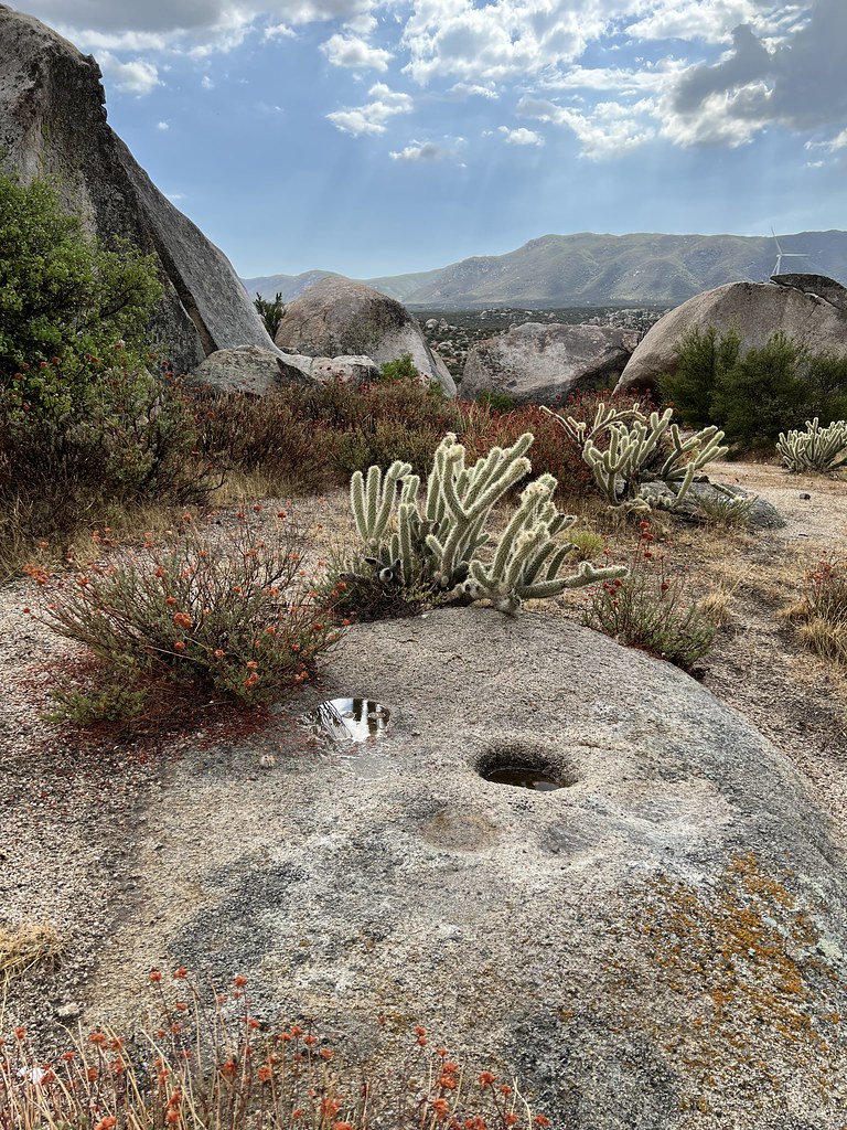 IMG_0114 by tomteske, on Flickr IMG_0114 by tomteske, on Flickr
 IMG_0115 by tomteske, on Flickr IMG_0115 by tomteske, on Flickr
Metate piece.
 IMG_0118 by tomteske, on Flickr IMG_0118 by tomteske, on Flickr
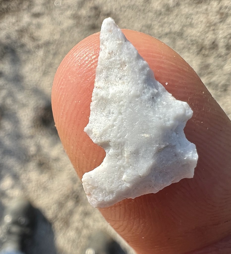
Found this little quartz Desert Side Notch point. It's a little beat up and missing a tang and barb but pretty hard to find anything these days out in McCain due to massive illegal collection over the decades.
 IMG_0126 by tomteske, on Flickr IMG_0126 by tomteske, on Flickr
Rock shelter with a few faded pictos all DStretched.
 IMG_0129 by tomteske, on Flickr IMG_0129 by tomteske, on Flickr
 IMG_0153 by tomteske, on Flickr IMG_0153 by tomteske, on Flickr
 IMG_0157 by tomteske, on Flickr IMG_0157 by tomteske, on Flickr
 IMG_0149 by tomteske, on Flickr IMG_0149 by tomteske, on Flickr
Found another Desert Side Notch walking on a stream bank. It also lost one of its tangs and a bit of a barb.
 IMG_0178 by tomteske, on Flickr IMG_0178 by tomteske, on Flickr
 IMG_0190 by tomteske, on Flickr IMG_0190 by tomteske, on Flickr
Headed over to a "topo spring" I'd never been to. Didn't expect much but almost looked like it could still have some water.
 IMG_0204 by tomteske, on Flickr IMG_0204 by tomteske, on Flickr
Did have a wet spot but may have just been the rain.
 IMG_0207 by tomteske, on Flickr IMG_0207 by tomteske, on Flickr
Expected ranching stuff was around. These metal troughs are kinda tough to escape if you're a critter and this rodent and his amphibian buddy didn't make it out alive.
 IMG_0230 by tomteske, on Flickr IMG_0230 by tomteske, on Flickr
 IMG_0237 by tomteske, on Flickr IMG_0237 by tomteske, on Flickr
 IMG_0233 by tomteske, on Flickr IMG_0233 by tomteske, on Flickr
Nearby was this benchmark. Don't think I've ever seen a Boy Scout BM but why not? Looks like it was run over since I couldn't move it upright.
 IMG_0244 by tomteske, on Flickr IMG_0244 by tomteske, on Flickr
 IMG_0250 by tomteske, on Flickr IMG_0250 by tomteske, on Flickr
A nice 8 mile hike with little elevation g/l but was a "chilly" 74 when I made it back. This toad was making the perilous journey across from Cottonwood West to East right when I was leaving. Hope he makes it. Enjoy!
 IMG_0263 by tomteske, on Flickr IMG_0263 by tomteske, on Flickr |
8/15/2022
Topic:
Cuyamaca
tommy750
|
Thought that snake pic looked familiar! Saw it on reddit this morning. Nice find, Rocko. |
8/16/2022
Topic:
Cuyamaca
tommy750
|
Rocko1 wrote:
tommy750 wrote:
Thought that snake pic looked familiar! Saw it on reddit this morning. Nice find, Rocko.
12 rattles on this one. What do you think of that skull Tommy? Look like a coyote?
Wasn't sure what that was and was thinking coyote skulls would have more of a pointy snout but coyote internet pics sure look like this. Am waiting for Ziphius to join the chat. |
8/16/2022
Topic:
McCain Valley
tommy750
|
Rocko1 wrote:
Great finds! You really have a built in dowsing rod for artifacts! I find a couple of pot shards and I am ecstatic. Was that trough being fed by that spring or just collecting rain water? How hot was it while you were out there?
There was a few inches of water in the trough and assuming it was from a recent rain. Smelled really bad from the decomposing critters. May stop by in the future to check on it. Earlier this year, I spotted a beat up trough on GE near the end of McCain Valley Rd and it had a nice nearby spring with decent flow. It was not present on the topo map
Was in the low 80s most of the hike and got nice and cool with the rain. Usually too lazy to get out early when it's cooler |
8/16/2022
Topic:
McCain Valley
tommy750
|
dsefcik wrote:
Surprised that old trough is holding water..looks like a nice day bike.
Trough must have been Boy Scout Strong Wanted to put a rescue stick/ladder in it but didn't seen anything handy. |
8/17/2022
Topic:
McCain Valley
tommy750
|
Brian wrote:
Great pics. I've only been to McCain Valley a couple times. I did the hike to Sombrero Peak and a bike ride to Carizo overlook. The bike ride was probably about 10 years ago. I remember there were helicopters placing the towers for the power lines at the time. I've always intended to go back and explore more but it hasn't happened yet.
If you liked the transmission towers, c'mon on back and check out the few dozen wind turbines! Not happy with them, but at least they're producing clean energy unlike the Ocotillo Wind project which only produced a dirty corporate tax break. |
8/21/2022
Topic:
McCain Valley
tommy750
|
rockhopper wrote:
Good eye on those quartz arrow points! Probably hunting for rabbit, squirrel and bird. The obsidian source was below the surface of Lake Cahuilla at the time perhaps? Nice trail report.
Perhaps indeed. Did see a few obsidian flakes but I'm assuming there's been a lot of disturbance all through that area so who knows when they showed up. |
11/3/2022
Topic:
Pinyon Ridge and Wilson BM
tommy750
|
NIce TR, Rocko1. Is that a Zpacks Duplex tent? Looks familiar. Have been packing the Altaplex the past few years and definitely like the weight but setting up the ten guylines is a speck annoying at the end of the day. Glad you got out. |