|
Rocko1 Posts: 588
9/13/2019
|
I am thinking about the best route of going from Salton Sea to Cuyamaca Lake. Would be 3 day trip, in winter/cooler weather, with water caches. I put this route together. Any thoughts or improvements would be appreciated. Rough draft-https://caltopo.com/m/VBL1
edited by Rocko1 on 9/13/2019
|
|
|
link
|
|
ziphius Posts: 911
9/14/2019
|
I've had the same goal for some time now, with most of my proposed routes coming in at around 65-75 miles. Your route comes in at about 68 miles from your Caltopo link. Doing that in 3 days seems ambitious, even with water drops, but maybe you're ultra-running it or hiking through the night? If you do it during a full-moon and get lucky with the weather, you can save on water by doing some night sections, especially in the eastern half where terrain is easier.
edited by ziphius on 9/14/2019
--
http://www.coyotelearning.org
|
|
|
+1
link
|
|
dsefcik Administrator Posts: 2609
9/14/2019
|
Can't do full research right now but Google Lost Boys 50 mile ultra run. I used to run that foot race and it went from pinyon wash to cuyamaca vc/school. Will take a look at route later when I get a chance.
--
http://www.sefcik.com
http://www.darensefcik.com
http://www.carrizogorge.com
|
|
|
+1
link
|
|
dsefcik Administrator Posts: 2609
9/15/2019
|
I might offer a suggestion of cutting south at earthquake valley and thru blair/box cyn and going up oriflamme instead.
--
http://www.sefcik.com
http://www.darensefcik.com
http://www.carrizogorge.com
|
|
|
+1
link
|
|
dsefcik Administrator Posts: 2609
9/15/2019
|
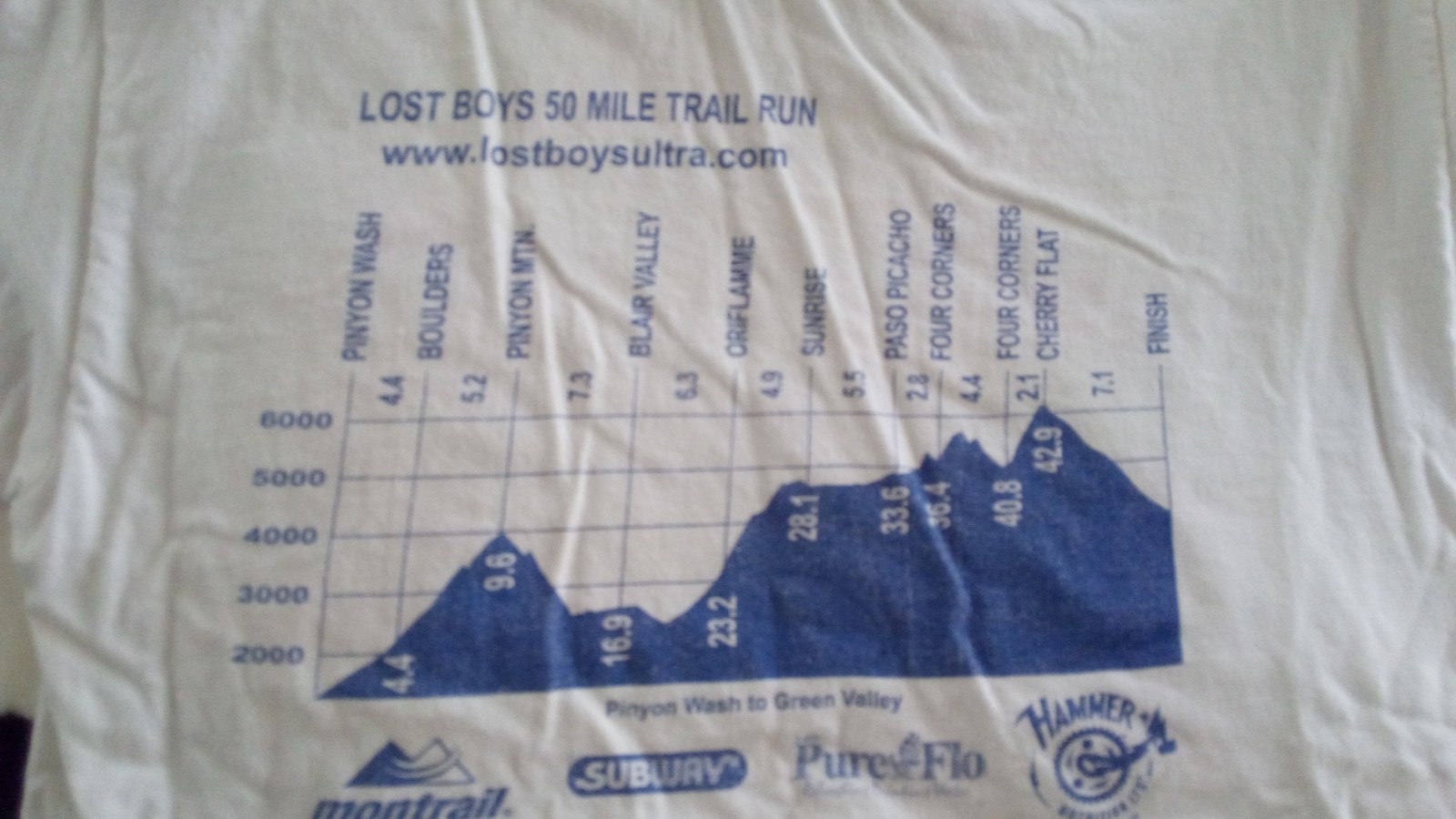
Here is the back of one of my old shirts from the race, it can give you some real miles along the way.
edited by dsefcik on 9/15/2019
--
http://www.sefcik.com
http://www.darensefcik.com
http://www.carrizogorge.com
|
|
|
+1
link
|
|
tommy750 Posts: 1040
9/15/2019
|
Roughly following San Felipe Creek/Old Kane Springs Rd to Fish Creek to Sandstone Canyon to Storm or Cottonwood or Oriflame Canyon would shave off 6-10 miles. Looks like a nice trek whatever route you chose.
|
|
|
+1
link
|
|
dsefcik Administrator Posts: 2609
9/16/2019
|
If I had the extra time I would join you....looks like a great route.
--
http://www.sefcik.com
http://www.darensefcik.com
http://www.carrizogorge.com
|
|
|
link
|
|
Rocko1 Posts: 588
9/16/2019
|
tommy750 wrote:
Roughly following San Felipe Creek/Old Kane Springs Rd to Fish Creek to Sandstone Canyon to Storm or Cottonwood or Oriflame Canyon would shave off 6-10 miles. Looks like a nice trek whatever route you chose.
I will look at modifying the route. Thanks for the tip.
The reason I chose a more northern route is 1) I am more familiar with that area and 2) it seemed to have easier points to do water caches and or bail out points.
|
|
|
link
|
|
Rocko1 Posts: 588
9/16/2019
|
dsefcik wrote:
If I had the extra time I would join you....looks like a great route.
That would be great.
I modified the track a bit adding cache locations/camp spots. Here is how it breaks down now.
Day 1) 28 miles 1,000ft of gain
Day 2) 14 miles 2,450ft of gain
Day 3) 22 miles 4,000ft of gain
Needs further work to lessen day 1, extend day 2.
|
|
|
link
|
|
Rocko1 Posts: 588
9/16/2019
|
dsefcik wrote:
I might offer a suggestion of cutting south at earthquake valley and thru blair/box cyn and going up oriflamme instead.
I think this makes sense. Seems to cut 2.5 miles and 800ft gain off. Thanks.
edited by Rocko1 on 9/16/2019
|
|
|
link
|
|
dsefcik Administrator Posts: 2609
9/18/2019
|
I would also suggest staying out of Oriflamme if it is a holiday weekend or such as there will be 5 million jeeps on that dirt road.
--
http://www.sefcik.com
http://www.darensefcik.com
http://www.carrizogorge.com
|
|
|
+1
link
|
|
Rocko1 Posts: 588
9/18/2019
|
dsefcik wrote:
I would also suggest staying out of Oriflamme if it is a holiday weekend or such as there will be 5 million jeeps on that dirt road.
Thanks. I did consider that. Hitting the PCT near Scissors Crossing would eliminate that issue but add a couple of miles.
|
|
|
link
|
|
rockhopper Posts: 668
9/20/2019
|
Sounds like a interesting adventure trek. Personally I would follow the San Felipe creek, cut across Split mountain gap and onward to Auga Caliente route to avoid the traffic along the 78. Packing water would be the main issue. Good luck. Keep us posted.
|
|
|
+1
link
|
|
Rocko1 Posts: 588
9/20/2019
|
rockhopper wrote:
Sounds like a interesting adventure trek. Personally I would follow the San Felipe creek, cut across Split mountain gap and onward to Auga Caliente route to avoid the traffic along the 78. Packing water would be the main issue. Good luck. Keep us posted.
Doing water caches on that route would be difficult-that's why I chose to finish the days near a road. Thinking I might have my brother meet me at the cache/camp locations too.
Even in cooler weather I will probably need to carry 6L.
|
|
|
link
|
|
rockhopper Posts: 668
9/22/2019
|
Rocko1 wrote:
rockhopper wrote:
Sounds like a interesting adventure trek. Personally I would follow the San Felipe creek, cut across Split mountain gap and onward to Auga Caliente route to avoid the traffic along the 78. Packing water would be the main issue. Good luck. Keep us posted.
Doing water caches on that route would be difficult-that's why I chose to finish the days near a road. Thinking I might have my brother meet me at the cache/camp locations too.
Even in cooler weather I will probably need to carry 6L.
Right. The Kane spring to Auga Caliente route is over 35 miles on foot with a lot of cross country. Would probably need a water cache' at or around split mountain or carry 2 days worth. Having your brother help is a great idea.
Cheers
|
|
|
+1
link
|
|
Rocko1 Posts: 588
11/4/2019
|
dsefcik wrote:
Here is the back of one of my old shirts from the race, it can give you some real miles along the way.

edited by dsefcik on 9/15/2019
That race looks awesome but brutal. I was hoping they had the gps track but I didn't see that on the website.
Found out my brother is moving out of state soon so this trip may have to be shelved for a bit.
|
|
|
link
|
|
rockhopper Posts: 668
11/4/2019
|
Rocko1 wrote:
dsefcik wrote:
Here is the back of one of my old shirts from the race, it can give you some real miles along the way.
edited by dsefcik on 9/15/2019
That race looks awesome but brutal. I was hoping they had the gps track but I didn't see that on the website.
Found out my brother is moving out of state soon so this trip may have to be shelved for a bit.
Right, That 50 miles lost boys run on your T-shirt looked insanely tough. World class athletes, please apply.
My condolences on your brother's move.
|
|
|
link
|
|
deborah Posts: 115
11/4/2019
|
Rocko1 wrote:
dsefcik wrote:
Here is the back of one of my old shirts from the race, it can give you some real miles along the way.
edited by dsefcik on 9/15/2019
That race looks awesome but brutal. I was hoping they had the gps track but I didn't see that on the website.
Found out my brother is moving out of state soon so this trip may have to be shelved for a bit.
I put a route for this run into CalTopo a little while ago. I haven't done the run myself, but I was curious. It looks like a beast.  I based the route on the website description. Hopefully it's representative. I can't remember why I broke it up into sections. It was either for cut-off times, or maybe just playing around with fun day hikes. I based the route on the website description. Hopefully it's representative. I can't remember why I broke it up into sections. It was either for cut-off times, or maybe just playing around with fun day hikes.
Anyway, here's a link to map. I think I have it set to be visible, but let me know if you can't get to it.
https://caltopo.com/m/VLAV
|
|
|
+1
link
|
|
dsefcik Administrator Posts: 2609
11/4/2019
|
deborah wrote:
Anyway, here's a link to map. I think I have it set to be visible, but let me know if you can't get to it.
https://caltopo.com/m/VLAV
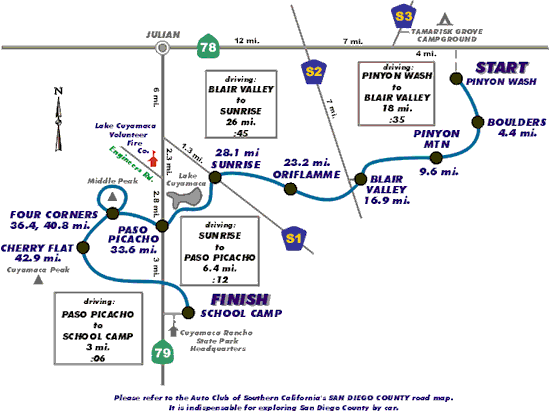
Your route is slightly different than the original...check out the wayback machine for the last one:
https://web.archive.org/web/20030603211938/http://www.lostboysultra.com/
Here is the course map
--
http://www.sefcik.com
http://www.darensefcik.com
http://www.carrizogorge.com
|
|
|
link
|
|
dsefcik Administrator Posts: 2609
11/4/2019
|
Rocko1 wrote:
That race looks awesome but brutal. I was hoping they had the gps track but I didn't see that on the website.
Found out my brother is moving out of state soon so this trip may have to be shelved for a bit.
Hope you get a chance to get back out there and do it.
--
http://www.sefcik.com
http://www.darensefcik.com
http://www.carrizogorge.com
|
|
|
link
|
|
Rocko1 Posts: 588
11/5/2019
|
dsefcik wrote:
deborah wrote:
Anyway, here's a link to map. I think I have it set to be visible, but let me know if you can't get to it.
https://caltopo.com/m/VLAV
Your route is slightly different than the original...check out the wayback machine for the last one:
https://web.archive.org/web/20030603211938/http://www.lostboysultra.com/
Here is the course map
I always forget about the archive. Thanks.
edited by Rocko1 on 11/5/2019
|
|
|
link
|
|
Rocko1 Posts: 588
11/5/2019
|
deborah wrote:
Rocko1 wrote:
dsefcik wrote:
Here is the back of one of my old shirts from the race, it can give you some real miles along the way.
edited by dsefcik on 9/15/2019
That race looks awesome but brutal. I was hoping they had the gps track but I didn't see that on the website.
Found out my brother is moving out of state soon so this trip may have to be shelved for a bit.
I put a route for this run into CalTopo a little while ago. I haven't done the run myself, but I was curious. It looks like a beast. I based the route on the website description. Hopefully it's representative. I can't remember why I broke it up into sections. It was either for cut-off times, or maybe just playing around with fun day hikes.
Anyway, here's a link to map. I think I have it set to be visible, but let me know if you can't get to it.
https://caltopo.com/m/VLAV
That is awesome! Thank you.
Seems no matter how I slice it, I just can't get the mileage under 63 or so.
edited by Rocko1 on 11/5/2019
|
|
|
link
|
|
Rocko1 Posts: 588
8/10/2022
|
Well, after mulling this over for a year, I have decided to not reinvent the wheel, do the extra mileage and take the SDTCT trail to Cuyamaca. Couple reasons. 1) It's much easier to cache water/water food. 2)I want to complete the SDTCT trail at some point and don't want to have to redo that section. 3) Less important but still valuable, much easier bail out points if needed.
Here is my plan for November:
Day 1-Salton Sea to 2 miles south of Villager Trail head off Thimble Trail. Pick up cache at at S22 and Ella Wash. 23-24 mile day.
Day 2- Fonts Point Wash to Culp Valley Campground. Prob. cache water here to-not sure Pena is reliable. 18 mile day, large climb out of BS.
Day 3-Culp to Box Canyon-Pick up Cache. 25 miles
Day 4-Box Canyon up Mason Valley Truck Trail, cross S1 at Pedro Fages monument and head to Lake Cuyamaca. 13 miles.
Total will be 80 miles +/-. 10,000 gain, 5,400ft loss.
Map - https://caltopo.com/m/0A3SJ
edited by Rocko1 on 8/10/2022
|
|
|
link
|
|
dsefcik Administrator Posts: 2609
8/11/2022
|
Rocko1 wrote:
Well, after mulling this over for a year, I have decided to not reinvent the wheel, do the extra mileage and take the SDTCT trail to Cuyamaca. Couple reasons. 1) It's much easier to cache water/water food. 2)I want to complete the SDTCT trail at some point and don't want to have to redo that section. 3) Less important but still valuable, much easier bail out points if needed.
Here is my plan for November:
Day 1-Salton Sea to 2 miles south of Villager Trail head off Thimble Trail. Pick up cache at at S22 and Ella Wash. 23-24 mile day.
Day 2- Fonts Point Wash to Culp Valley Campground. Prob. cache water here to-not sure Pena is reliable. 18 mile day, large climb out of BS.
Day 3-Culp to Box Canyon-Pick up Cache. 25 miles
Day 4-Box Canyon up Mason Valley Truck Trail, cross S1 at Pedro Fages monument and head to Lake Cuyamaca. 13 miles.
Total will be 80 miles +/-. 10,000 gain, 5,400ft loss.
Map - https://caltopo.com/m/0A3SJ
edited by Rocko1 on 8/10/2022
Seems reasonable and fun...!
--
http://www.sefcik.com
http://www.darensefcik.com
http://www.carrizogorge.com
|
|
|
link
|
|
Rocko1 Posts: 588
8/11/2022
|
dsefcik wrote:
Rocko1 wrote:
Well, after mulling this over for a year, I have decided to not reinvent the wheel, do the extra mileage and take the SDTCT trail to Cuyamaca. Couple reasons. 1) It's much easier to cache water/water food. 2)I want to complete the SDTCT trail at some point and don't want to have to redo that section. 3) Less important but still valuable, much easier bail out points if needed.
Here is my plan for November:
Day 1-Salton Sea to 2 miles south of Villager Trail head off Thimble Trail. Pick up cache at at S22 and Ella Wash. 23-24 mile day.
Day 2- Fonts Point Wash to Culp Valley Campground. Prob. cache water here to-not sure Pena is reliable. 18 mile day, large climb out of BS.
Day 3-Culp to Box Canyon-Pick up Cache. 25 miles
Day 4-Box Canyon up Mason Valley Truck Trail, cross S1 at Pedro Fages monument and head to Lake Cuyamaca. 13 miles.
Total will be 80 miles +/-. 10,000 gain, 5,400ft loss.
Map - https://caltopo.com/m/0A3SJ
edited by Rocko1 on 8/10/2022
Seems reasonable and fun...!
Thanks Daren. May push this to first week in December. I forgot how busy the time around Thanksgiving is in the washes-don't want to get run over by ATV..
|
|
|
link
|
|
rockhopper Posts: 668
8/21/2022
|
There is an old native American trail that cuts across the bad lands from Kane springs towards Clark Lake south of S22. Sections of the trail on the desert pavement are still visible but most of it is eroded into history. You would probably be the first person to traverse it in over 100 years on foot. Sounds like an epic expedition any way you do it.
Cheers
|
|
|
link
|