2/9/2012
Topic:
San Felipe Valley Wildlife Area
herofix
|
Greetings all,
Long time reader, first time poster.
I'm wondering if anyone here has explored the subject area, as it is so close to the ABDSP and along a major ingress route to the park. I rode through the valley with the Boy Scouts many years ago and was captivated by the silence and solitude to be found there. I'm planning a trip out that way to check out a few short hikes in the Lindsay guidebook, and was curious if anyone has any experience with the area, specifically if there's anything of interest along the trail thru there. Here's a link to the CA Fish and Game info site for the area: http://www.dfg.ca.gov/lands/wa/region5/sanfelipe/index.html
Thanks and I'll be sure to post pics and a trip report when I return.
Dan
edited by herofix on 2/9/2012
edited by herofix on 2/9/2012
edited by herofix on 2/9/2012
<em>edited by herofix on 2/9/2012</em> |
3/1/2012
Topic:
ABDSP Via Sunrise HWY
herofix
|
Isn't there a section of the Fages trail up near that area? I seem to recall hiking down to Oriflamme Canyon with the Boy Scouts from a mountain road like that...the pic with the caption "Right across the street there is a jeep trail, that I think goes north towards oriflamme canyon" looks familiar, as does the Lucky 5 Ranch view. |
3/21/2012
Topic:
San Felipe Valley / Plum Canyon / Yaqui Well
herofix
|
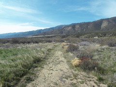
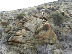
About a month ago on President's Day I took a drive out of Escondido heading for ABDSP to check out a few hikes in the Lindsay guidebook. On the way there I stopped off at the San Felipe Valley Wildlife Area to "see what I could see". As it turned out, the answer was "not much", though I did enjoy the wide-open feel of the trail and serene silence found just a few hundred yards off S-2. I didn't see much wildlife, though...at least not directly.
Views from the trailhead:


The trail looks like an old ranch road, though I believe it may be part of the California Hiking and Riding Trail:
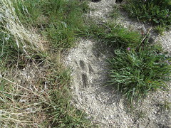
Like I said, I didn't directly observe any wildlife, though I did find this track, which I thought might be from a mountain lion:
Granite Mountain had some snow on its shoulders from the storm that had blown through that weekend:

Next I headed down 78 toward Ocotillo Wells. Passing through the Sentenac Cienega area, I paused to look for the remains of the stone cabin mentioned in the Lindsay book. Has anyone ever checked it out? I couldn’t see anything from the road and don’t know if there’s a trail nearby.

I proceeded down canyon until I turned off at the Plum Canyon sign and proceeded up the dirt road about two miles, taking the right fork to what I *thought* was the trailhead:
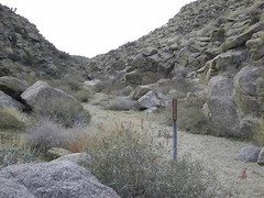
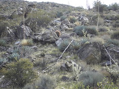
I now realize that the "short hike to a viewpoint overlooking Earthquake Valley" may have been at the end of the *left* fork. I swear I must have hiked 2+ miles (my definition of a "short hike") and didn't find any such viewpoint. Anybody know for sure? It was a great hike anyway, as I had the trail to myself. There are also numerous rock formations, dry waterfalls and other interesting stuff to look at:

After that excursion I wasn’t quite worn out and wanted to see more, since I don't get out that way very often. I headed down Yaqui Pass Road and parked by the closed Tamarisk Grove campground. Anyone know why it is closed? I'm guessing state budget cuts.
Some friendly fellow hikers offered me the last copy of the trail pamphlet, so I headed out on the short Yaqui Well trail. After a pleasant but uneventful stroll, I arrived at Yaqui Well. Even in late February I would have expected it to have some visible water, but as you can see it was largely dry. There were quite a few bees or wasps flying into the vegetation, so I would bet there was still some water down there somewhere:

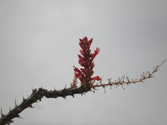
On the way back I passed a few ocotillo with buds just starting to bloom:
All in all, it was a good trip, though I didn't see exactly what I was expecting. Passing through Julian on the way home I picked up an Apple Boysenberry pie at Mom's, and that always helps make a successful excursion.
<em>edited by herofix on 5/9/2012</em> |
3/22/2012
Topic:
San Felipe Valley / Plum Canyon / Yaqui Well
herofix
|
Interesting, thanks for the topo view. The whole time I was hiking I kept thinking "it must be just around the bend", but the path stayed down in the wash and never rose or opened up to any viewpoint. I guess I just didn't go far enough, but it sure seemed like it...
By the way, how did you map out your route and distance? Is a GPS required for that, or can you use a pedometer or similar device? I'd love to know how far I go each time.
Thanks. |
4/2/2012
Topic:
2012 Wildflowers are beginning to bloom
herofix
|
Beautiful! Really great shots; thanks for sharing. |
4/11/2012
Topic:
Where the wild flowers weren't.
herofix
|
Great pics, thanks for sharing. Love your tongue-in-cheek reporting on the (lack of) flowers, too. |
4/18/2012
Topic:
Mason Valley Truck Trail /CRHT to abandoned mines
herofix
|
Hi all,
Anyone have experience hiking to the old mines in the Chariot Canyon area? I'd like to hike down from Sunrise Highway and back in the same day, and according to a rough calculation on the CalTopo map, it's about 5 miles each way. According to this Schad article (link), the trail is "rougher and harder" than descending into Oriflamme Canyon on the truck trail. I know Darren has mentioned running through this area...is it worth checking out?
Thanks for any input. I'll likely go the first weekend in May, as I'm hoping it won't be too warm out there yet at 3600-4600 feet.
Dan |
4/19/2012
Topic:
Mason Valley Truck Trail /CRHT to abandoned mines
herofix
|
Excellent! Thanks very much for the detailed map and advice. I'll definitely take the Banner route, as it's shorter and definitely sounds easier. I'll definitely post a TR when I return.
Thanks again.
Dan |
4/19/2012
Topic:
Near Piedras Grandes and Dos Cabezas
herofix
|
Awesome pics! Thanks for sharing. |
4/19/2012
Topic:
Mason Valley Truck Trail /CRHT to abandoned mines
herofix
|
No worries...that CalTopo site is indeed very cool. I plan on downloading a copy of the map to Google Earth to take along.
Dan |
4/23/2012
Topic:
Mason Valley Truck Trail /CRHT to abandoned mines
herofix
|
Don't worry about me...last thing I want is to encounter some dusty prospector with a shotgun thinking I'm there to steal his gold!  |
4/24/2012
Topic:
Best spots to camp
herofix
|
Great pic! Thanks for sharing. |
5/9/2012
Topic:
Body recovered from Anza Borrego Mud Caves
herofix
|
Very sad indeed, and a reminder to anyone (many of us!) that may go exploring in remote areas alone. I thought of this young man while I was checking out the gold mines near Banner this past weekend. If something had happened, it would have been a long time before I was found, even though I told people where I was going and stayed near a well-traveled road.
RIP Guillermo |
5/10/2012
Topic:
Body recovered from Anza Borrego Mud Caves
herofix
|
anutami wrote:
Herofix, would love to see your trip report on the mines you explored 
Thanks, yeah I'll be posting it soon. If only work would quit getting in the way!
Dan |
5/15/2012
Topic:
3D Panoramic Virtual Tours
herofix
|
Agreed, those are awesome. How do you get Google to host content that large? I can't even figure out how to display my trip pics at full size! |
5/16/2012
Topic:
Hike through Banner mine district
herofix
|
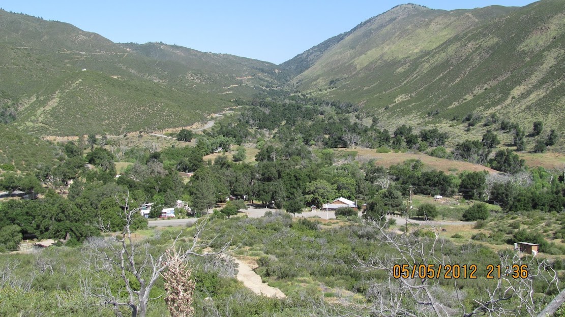
On May 6th I headed to Banner to check out what I could see of any abandoned gold mines. Having only passed through the area a few times I didn't realize that the route is basically an old fire road that heads pretty much straight uphill! But I drove a long way to get there and was undaunted in my quest. I was going to park at the Banner Store but it wasn't open yet and there were a bunch of signs saying "customers only", so I parked just off Banner Pass under an oak tree and started hiking up.
Here's a view from near the start...Banner Store is in foreground and the road to Julian snakes up the canyon beyond:
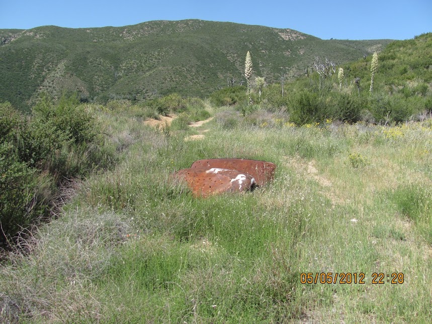
About 1/2 way to the top of the ridge I came across these blocks that looked like old cattle troughs of some kind. The top of the one on the left says "SHOOTING 1 MI". More on that in a moment:

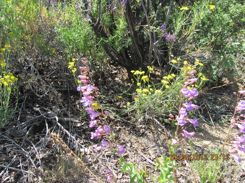
It was a beautiful day, about 72-75 degrees without a cloud in sight. Lots of wildflowers and other plants were in bloom:


According to the Cal Topo map (thanks Daren), there are numerous mines all around this area, but most were not easy to see from the road. This side road pretty clearly led up to something, so I gave it a shot:
End of the line was just this open area, which may have had a structure on it at one time, but no mine opening was in evidence. Based on map comparisons, I'm pretty sure this was near the location of the Golden Ella Mine:

Back on the main road, I could see what I believe to be the still-active Chariot/Golden Chariot mines down below:

Through binocs:

I would have headed down there for a closer look but I didn't want to run into any gun-toting prospectors. I started back down and stopped by the "shooting" area mentioned earlier, as there was an overgrown old road nearby that looked promising:

There were tons of spent cartridges and clay pigeons all over the ground in this area, so I assume it's some kind of open-air range:

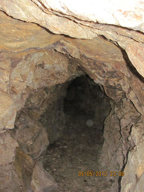
Anyway, I finally located a mine opening that I could reach. This one doesn't appear to be named on the maps that I saw:

The opening wasn't very large, so I had to stoop down to get inside:

I can't imagine trying to actually chisel ore out of solid granite while on your knees:

I didn't go in very far because I (stupidly) didn't bring a flashlight. What kind of dummy goes spelunking without a light?:
A little further along on my way down I found another caved-in mine opening; this one runs under the Rodriguez Spur Truck Trail near where it splits from the main road I was on:

All in all, it was an interesting hike, except for all the boring walking parts (which I left out). I didn't see much wildlife to speak of other than a few birds high above and garden variety lizards on the rocks. I didn't feel like I was violating any laws by going off the main road, since at no time during this trek did I see a single "private property" or "no trespassing" sign (I know that doesn't mean it's not private property, just saying). The road was actually quite busy, and I was passed by numerous 4x4's and Jeeps on their way up the hill. Toward the end I met up with some young dudes out exploring as well, except they were in a truck and when they jumped out to look at that last mine with me, one of them had a huge machete in his hand. He sees at me looking at it and he says "this isn't for you; it's in case of rattlesnakes". Glad to hear it, bro!
Sorry for the lame timestamps on the pics; I was using a borrowed camera. Thanks for reading!
<em>edited by herofix on 5/16/2012</em> |
5/17/2012
Topic:
Hike through Banner mine district
herofix
|
Thanks all for checking out my report.
Ziphius, I thought the same thing about the liability for property owners, but there were no signs and only 1 fence or gate that I saw on that whole trek, and that was around the caved-in entrance in the last pic...but it was wide open. I wouldn't have hopped a fence to gain access but some might and could get hurt.
Daren, thanks again for the map and detailed info. You did indeed mention that it was a fire road but when viewed from above it was hard to gauge elevation. Still, I'm certain that it was much better than coming in from the Fages trail direction. I definitely got plenty of exercise walking up there! I think I may head out there again in the future, but NEXT time I'll have a flashlight AND I'll drive at least partway up first!
Oh and the trash in the mine entrance was weird. The box with blue writing says "Kirkland Butter" (Costco), so it's clearly not historic miner trash! My bet is that the shooters from the nearby range dumped their crap in there.
And Rockhopper, your comment about your mine exploring days begs for more details! Do tell...
Dan
<em>edited by herofix on 5/17/2012</em> |
5/20/2012
Topic:
Hike through Banner mine district
herofix
|
WOW!!  What an amazing story! Your friend's dog was extraordinarily lucky to land on a "soft spot" in an abandoned mine shaft...a one in a million chance. I was thinking of similar stories when I was just *looking* into that mine tunnel, so that helped keep me from going further. Well, that and no flashlight. What an amazing story! Your friend's dog was extraordinarily lucky to land on a "soft spot" in an abandoned mine shaft...a one in a million chance. I was thinking of similar stories when I was just *looking* into that mine tunnel, so that helped keep me from going further. Well, that and no flashlight.
Thanks for sharing.
Dan |
8/7/2012
Topic:
Horseshoe Canyon Rock Art Site
herofix
|
You always take the greatest pics. Thanks for sharing! |
9/4/2012
Topic:
Lost Valley
herofix
|
Thanks for the link to the story. I've read about Lost Valley with fascination for several years now. Does anyone know where to get additional info about public trails in the area? |
11/16/2012
Topic:
Changed Post Thread Sorting
herofix
|
I prefer it with the oldest first, esp. in when it's a new trip report. That way you see all the pics first and then other readers' comments below. But I'll defer to whatever the group decides, no big deal. |
1/8/2013
Topic:
Pinyon Wash to Harper Flat and Cabin
herofix
|
Great TR and pics. Thanks for sharing. I gotta get out there someday. |
1/10/2013
Topic:
Adding Images From Google - Picasa
herofix
|
Thanks for the tips, Bob. When I finally get around to posting my Thanksgiving hike, this will come in handy. |
2/20/2013
Topic:
Villager/Rabbit/Dawns Via Mojave & Rockhouse Cyn
herofix
|
Great report and pics! Those were amazing views you had...thanks for sharing. |
3/26/2013
Topic:
West Mesa and Ancient Lake Cahuilla
herofix
|
Fascinating! Thanks for posting, with all your excellent (as usual) pics and descriptions. That's an area waaaay beyond my range, so I'd never see it but for your report.
Dan |
1/6/2014
Topic:
Jamul Kiln Ruins
herofix
|
Fascinating! I think "backcountry" hikes like these relate enough to ABDSP to count for this forum, IMO. Thanks for the write up, as always. |
11/14/2014
Topic:
Rockhouse Canyon in Carrizo Gorge Backpack
herofix
|
Great pics as always, thanks for sharing. looks pretty rugged and remote out there. BTW, I think that SkyBlazer was Lot# 61 and expired in Oct. 2010.
edited by herofix on 11/14/2014 |
1/25/2016
Topic:
Anza Borrego Site Redo
herofix
|
Looks great, thanks for all your work on the site! |
6/8/2016
Topic:
Proposed closures in ABSP, read and act now
herofix
|
Thanks Bob for your efforts on ALL our behalf. Unless the state can point to specific negative impacts occurring in the proposed closure areas, there is no legitimate reason to close them at this time. We'll be out of town on the 22nd or I'd be there for the hearing to add my voice. |
1/4/2017
Topic:
Ghost Mountain Article
herofix
|
Thanks for sharing this event, I sure wish I could make it out there on a Friday afternoon...or a Tuesday before 2, for that matter. Such a fascinating man and topic. So glad I got to hear Rider speak in person a few years ago at the Escondido Library, where he signed a copy of Diana's book for me. Also whenever I'm in Julian I ask to see the murals that Marshall painted in various buildings there, including the basement of the Town Hall. |