|
tommy750 Posts: 1040
7/13/2020
|
Not exactly Anza Borrego but pretty much the same stuff: rocks and sand, heat, sheep, hiking, rock art, artifacts, exploring, you know. When the wife's planned trip to Baja fell through (expired passport and extension of travel ban), we decided to head to the Owens Valley area. Was going to be hot but figured we could camp either in the eastern Sierras or in the White Mts to stay cool and do whatever during the day. Made it to Indian Wells Canyon (near Inyokern) the first night and explored a rock art site reportedly dating mainly to the "Ghost Dance" period of the 1890's. The site had some nice pictos with some reportedly showing a rider with a white hat, the prophet Wavoka. During the trip started reading a book on the Ghost Dance and highly recommend it: https://www.amazon.com/Gods-Red-Son-Religion-America/dp/0465015026
One of two sites in Indian Wells Canyon:
 Indian Wells Canyon Pano_lxx_0.58_0.90_1.50 by tomteske, on Flickr Indian Wells Canyon Pano_lxx_0.58_0.90_1.50 by tomteske, on Flickr
 IMG_4288 by tomteske, on Flickr IMG_4288 by tomteske, on Flickr
Was planning on visiting the second site in the morning but constant 30-50 mph winds became unbearable so we just packed up at 0300 and headed north. Ended up near a site called Ayers Rock, reportedly the most researched picto site in California. Also one of the most plundered.
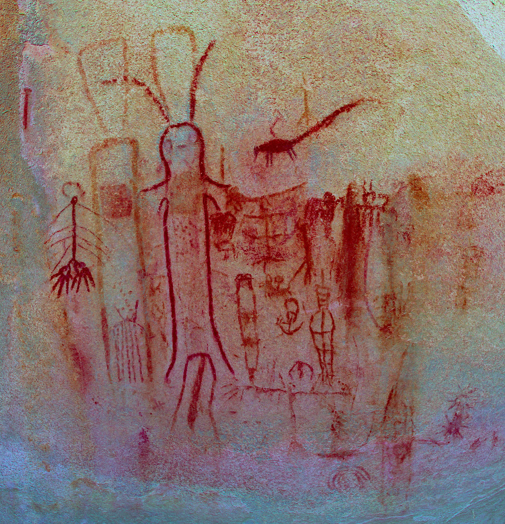
Ayers Rock is the large boulder at ground level left ot the Joshua Tree.
 Ayers Rock Pano by tomteske, on Flickr Ayers Rock Pano by tomteske, on Flickr
 Ayers Rock Panel 1_lxx_0.40_0.84_1.14 by tomteske, on Flickr Ayers Rock Panel 1_lxx_0.40_0.84_1.14 by tomteske, on Flickr
Not your typical anthropomorphs!
 Ayers Rock Bunny by tomteske, on Flickr Ayers Rock Bunny by tomteske, on Flickr
Very nice sheep and antelope panel.
 Ayers Rock Panel_lxx_0.42_0.84_1.38 by tomteske, on Flickr Ayers Rock Panel_lxx_0.42_0.84_1.38 by tomteske, on Flickr
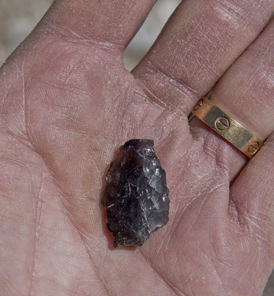
Walking back to the truck, found this really nice large projectile point with a broken tip and missing base. Probably the largest point I've ever seen and definitely atlatl/spear material.
 Ayers Rock Point by tomteske, on Flickr Ayers Rock Point by tomteske, on Flickr
We next headed up to the Bishop area. The heat kinda limited our activities but spent a relaxing evening near Buttermilk Boulders. Here's a rock art site associated with this area.
 Buttermilk Boulder Pano_lxx_0.36_0.78_1.02 by tomteske, on Flickr Buttermilk Boulder Pano_lxx_0.36_0.78_1.02 by tomteske, on Flickr
Went up Silver Canyon Rd toward the Ancient Bristlecone Pine Forest, a rather steep (4-Lo) route to the crest of the White Mts. Saw a ewe group of five ewes and two lambs. Not sure if that's a good or bad ratio of mommies to babies but you sheep counters would know. Almost felt like Buford with my camera a couple times since the sheep were pretty close to the road 
 Ewe Group With Two Lambs by tomteske, on Flickr Ewe Group With Two Lambs by tomteske, on Flickr
 Ewe on the DL by tomteske, on Flickr Ewe on the DL by tomteske, on Flickr
 Silver Canyon Switchbacks by tomteske, on Flickr Silver Canyon Switchbacks by tomteske, on Flickr
Camped at a nice plateau at about 8300 ft but still in the 90s when we got there. The evenings were always cool and had a great view of the night sky and Milky Way.
 Silver Canyon Road by tomteske, on Flickr Silver Canyon Road by tomteske, on Flickr
Visited the Patriarch Grove.
 Patriarch Grove by tomteske, on Flickr Patriarch Grove by tomteske, on Flickr
 Patriarch Grove A Giraud by tomteske, on Flickr Patriarch Grove A Giraud by tomteske, on Flickr
Found a nice ?western stemmed point in the middle of the tundra.
 Great Basin Stemmed Point by tomteske, on Flickr Great Basin Stemmed Point by tomteske, on Flickr
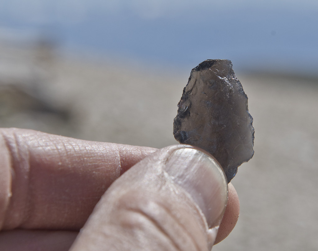 Great Basin Stemmed Point 3 by tomteske, on Flickr Great Basin Stemmed Point 3 by tomteske, on Flickr
Lots of nice little flowers in the tundra.
 Tundra Flowers by tomteske, on Flickr Tundra Flowers by tomteske, on Flickr
 Tundra Flowers 2 by tomteske, on Flickr Tundra Flowers 2 by tomteske, on Flickr
Hawk near a water trough.
 Hawk at Trough 2 by tomteske, on Flickr Hawk at Trough 2 by tomteske, on Flickr
 Hawk at Trough by tomteske, on Flickr Hawk at Trough by tomteske, on Flickr
Spent one night at Alabama Hills which is pretty, but.... Headed up to Whitney Portal for a mandatory water fall sighting per the spouse.
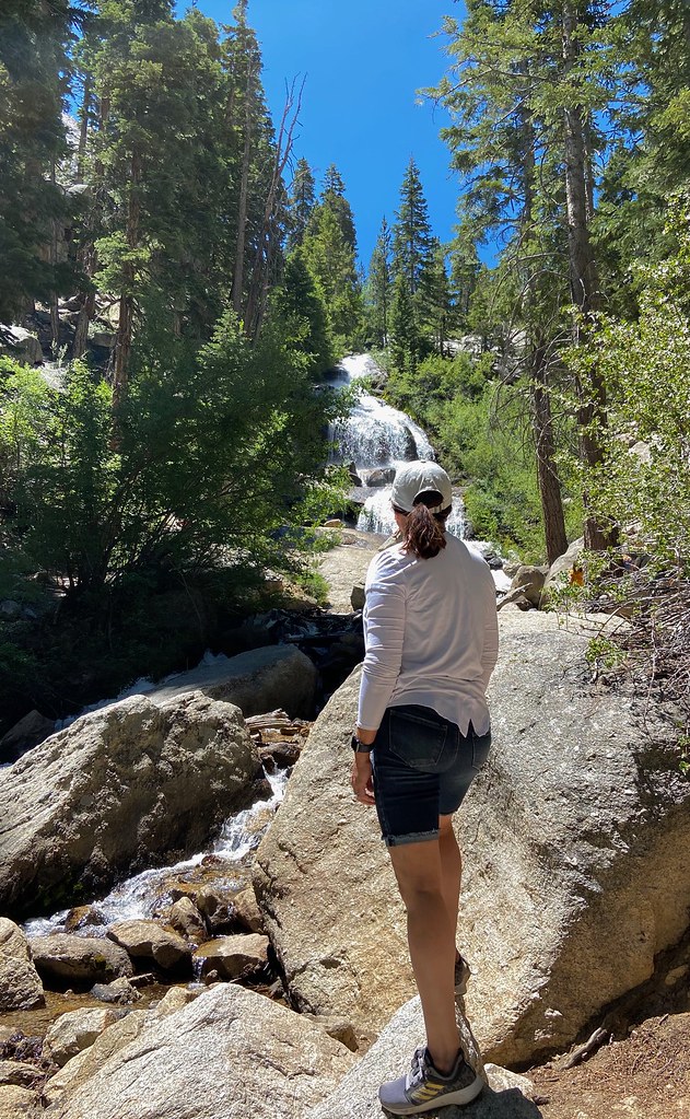 IMG_4411 by tomteske, on Flickr IMG_4411 by tomteske, on Flickr
 IMG_4403 by tomteske, on Flickr IMG_4403 by tomteske, on Flickr
One last rock art site on the way home.
 Walker Creek Boulder_xp-0.25_1.52 by tomteske, on Flickr Walker Creek Boulder_xp-0.25_1.52 by tomteske, on Flickr
And probably the wife's favorite camping spot after five days in the heat Did hook her up with a new shower setup and awning which was greatly appreciated by all.
 IMG_4439 by tomteske, on Flickr IMG_4439 by tomteske, on Flickr
About 1K mlles driving, maybe a couple miles hiking and another great time in the outdoors. Enjoy! Tom
|
|
|
+1
link
|
|
Rocko1 Posts: 588
7/14/2020
|
Very nice! I am always amazed at how you find these artifacts. You may have a built in dowsing rod ability for this stuff. 
|
|
|
link
|
|
tommy750 Posts: 1040
7/14/2020
|
Rocko1 wrote:
Very nice! I am always amazed at how you find these artifacts. You may have a built in dowsing rod ability for this stuff.
That's exactly what I used to say to everyone I went out with when they found stuff and I never did. Then one day I was out in Canebrake with Daren and found seven points. Now, it seems easier to find stuff. Guess something in your brain clicks and then they're much more obvious to locate.
|
|
|
+1
link
|
|
rockhopper Posts: 668
7/15/2020
|
Nice rock art expedition Tommy. The whole Owens valley was a major corridor to the early peoples for thousands of years so there is a lot of rock art out there. Speaking of thousands of years, that obsidian point you found on the White mountains is probably very very old. That has been a dry mountain for a long time with only seasonal creeks from snow melt. Was it found near a seasonal creek drainage? btw Years ago, when we went up to the Bristle cone forest / White mountains we smoke the clutch on our Ford Ranger going up the top locked gate just shy of the 14,000 ft+ summit weather station. I probably walked over your arrow point.
|
|
|
link
|
|
ziphius Posts: 911
7/15/2020
|
Great trip Tommy. Makes me miss the desert!
--
http://www.coyotelearning.org
|
|
|
link
|
|
tommy750 Posts: 1040
7/15/2020
|
rockhopper wrote:
Nice rock art expedition Tommy. The whole Owens valley was a major corridor to the early peoples for thousands of years so there is a lot of rock art out there. Speaking of thousands of years, that obsidian point you found on the White mountains is probably very very old. That has been a dry mountain for a long time with only seasonal creeks from snow melt. Was it found near a seasonal creek drainage? btw Years ago, when we went up to the Bristle cone forest / White mountains we smoke the clutch on our Ford Ranger going up the top locked gate just shy of the 14,000 ft+ summit weather station. I probably walked over your arrow point.
I found the point lying on the ground near where I took the BW bristlecone pic. Wasn't really near anything. Assuming the road to the research station used to be open?? Wow, that would have been a nice trip. Now the gate is at 11.7K and you've got a 15 mile 3K g/l hike ahead of you. I found out my Tundra had a transmission fluid temp idiot light going up Silver Canyon. Magically went away when I changed from 4-Hi to 4-Lo. Silver Canyon is the short cut from Bishop to the White Mts and is about a 6,200 feet climb in 9 miles with a 43% grade in places. Was about 100 degrees till above 8000 ft. Our camp site off the road had great views of the night sky but totally forgot about the comet. Need to check that out this weekend.
|
|
|
link
|
|
tommy750 Posts: 1040
7/15/2020
|
ziphius wrote:
Great trip Tommy. Makes me miss the desert!
What are you waiting for Ziphius?? Everything is open and Inner Pasture this weekend is probably only as hot as El Cajon Mt. during an illicit August dayhike.
|
|
|
+1
link
|
|
Rocko1 Posts: 588
7/16/2020
|
rockhopper wrote:
Nice rock art expedition Tommy. The whole Owens valley was a major corridor to the early peoples for thousands of years so there is a lot of rock art out there. Speaking of thousands of years, that obsidian point you found on the White mountains is probably very very old. That has been a dry mountain for a long time with only seasonal creeks from snow melt. Was it found near a seasonal creek drainage? btw Years ago, when we went up to the Bristle cone forest / White mountains we smoke the clutch on our Ford Ranger going up the top locked gate just shy of the 14,000 ft+ summit weather station. I probably walked over your arrow point.
I have read about the White Mtn Peak hike and the road going up to the trailhead. Didn't realize it was that steep.
|
|
|
link
|
|
Buford Posts: 453
7/16/2020
|
Nice report.
I like the sheep shots of course . Two lambs to five ewes is not terrible. ABDSP in July lamb survival is close to 0% some years and areas, other areas close to 70%. I don't know what normal is near the Bristlecones.
I have been meaning to make my way up to the White Mountains.
--
Links to my photos: ABDSP photos, Bighorn sheep photos, ABDSP time lapse video, Wildlife photos (mainly birds)
|
|
|
link
|
|
tommy750 Posts: 1040
7/17/2020
|
Buford wrote:
Nice report.
I like the sheep shots of course . Two lambs to five ewes is not terrible. ABDSP in July lamb survival is close to 0% some years and areas, other areas close to 70%. I don't know what normal is near the Bristlecones.
I have been meaning to make my way up to the White Mountains.
Thanks for the info. Couldn't find anything specific regarding sheep in that area but it's not endangered like the Sierra or Peninsular sheep and the forest service website mentions sighting in that area.
|
|
|
link
|
|
rockhopper Posts: 668
7/18/2020
|
Rocko1 wrote:
rockhopper wrote:
Nice rock art expedition Tommy. The whole Owens valley was a major corridor to the early peoples for thousands of years so there is a lot of rock art out there. Speaking of thousands of years, that obsidian point you found on the White mountains is probably very very old. That has been a dry mountain for a long time with only seasonal creeks from snow melt. Was it found near a seasonal creek drainage? btw Years ago, when we went up to the Bristle cone forest / White mountains we smoke the clutch on our Ford Ranger going up the top locked gate just shy of the 14,000 ft+ summit weather station. I probably walked over your arrow point.
I have read about the White Mtn Peak hike and the road going up to the trailhead. Didn't realize it was that steep.
It wasn't that steep. It was more our vehicle and the altitude. A older 90's Ford ranger with big tires and a small V6 fully loaded with a week of camping gear.
|
|
|
+1
link
|
|
ziphius Posts: 911
7/18/2020
|
Yes sir! I have plans! Just need to get over a nagging piriformis injury!
tommy750 wrote:
ziphius wrote:
Great trip Tommy. Makes me miss the desert!
What are you waiting for Ziphius?? Everything is open and Inner Pasture this weekend is probably only as hot as El Cajon Mt. during an illicit August dayhike.
--
http://www.coyotelearning.org
|
|
|
link
|
|
rockhopper Posts: 668
7/18/2020
|
tommy750 wrote:
rockhopper wrote:
Nice rock art expedition Tommy. The whole Owens valley was a major corridor to the early peoples for thousands of years so there is a lot of rock art out there. Speaking of thousands of years, that obsidian point you found on the White mountains is probably very very old. That has been a dry mountain for a long time with only seasonal creeks from snow melt. Was it found near a seasonal creek drainage? btw Years ago, when we went up to the Bristle cone forest / White mountains we smoke the clutch on our Ford Ranger going up the top locked gate just shy of the 14,000 ft+ summit weather station. I probably walked over your arrow point.
I found the point lying on the ground near where I took the BW bristlecone pic. Wasn't really near anything. Assuming the road to the research station used to be open?? Wow, that would have been a nice trip. Now the gate is at 11.7K and you've got a 15 mile 3K g/l hike ahead of you. I found out my Tundra had a transmission fluid temp idiot light going up Silver Canyon. Magically went away when I changed from 4-Hi to 4-Lo. Silver Canyon is the short cut from Bishop to the White Mts and is about a 6,200 feet climb in 9 miles with a 43% grade in places. Was about 100 degrees till above 8000 ft. Our camp site off the road had great views of the night sky but totally forgot about the comet. Need to check that out this weekend.
This was back in the 1990's . The graded dirt ( rocky) road was open up to a locked gate just below the summit. You could see the research station beyond.
Also, When ever we are traveling up in that area during the cool seasons we always stop at nearby Benton Hot Springs or Kehoe Hot springs for a soak and talk story with the locals.
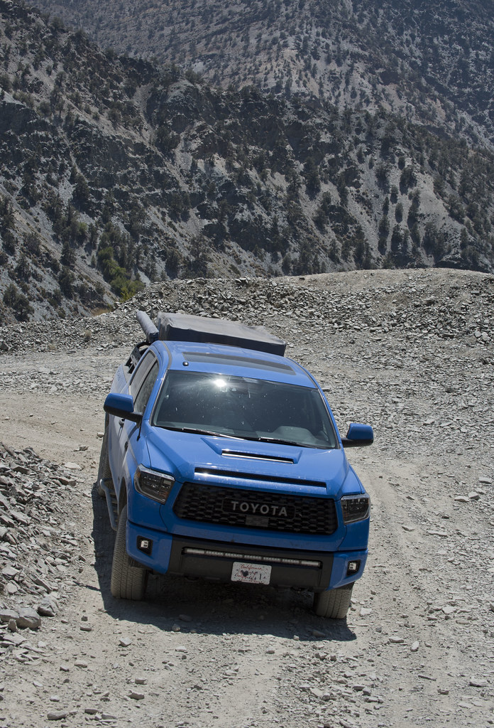
BTW nice Tundra and interesting camping set up.
|
|
|
+1
link
|
|
tekewin Posts: 365
7/29/2020
|
Thanks for report! It took me a few minutes to figure out that tent set up. Clever.
You got some close up sheep, always a treat. The White Mountains are still on my to-do list. I've heard the road is really long and rough.
|
|
|
link
|
|
dsefcik Administrator Posts: 2609
8/2/2020
|
Nice TR tommy750....Gary, myself and other gang members were not too far away up in the Domeland Wilderness and enjoyed some very hot summer weather as well. We did manage to see bears, deer and other local wildlife and some rock art. Glad you and the spouse had a good trip.
--
http://www.sefcik.com
http://www.darensefcik.com
http://www.carrizogorge.com
|
|
|
link
|
|
tommy750 Posts: 1040
8/2/2020
|
tekewin wrote:
Thanks for report! It took me a few minutes to figure out that tent set up. Clever.
You got some close up sheep, always a treat. The White Mountains are still on my to-do list. I've heard the road is really long and rough.
All the dirt roads on top we traveled on were not bad and you could easily drive 30-40 mph. Not really sure about other seasons, however.
|
|
|
link
|
|
tommy750 Posts: 1040
8/2/2020
|
dsefcik wrote:
Nice TR tommy750....Gary, myself and other gang members were not too far away up in the Domeland Wilderness and enjoyed some very hot summer weather as well. We did manage to see bears, deer and other local wildlife and some rock art. Glad you and the spouse had a good trip.
Definitely was warm out there. You guys probably had a nice portable shower at base camp like we did, right?? Looking forward to your post!
|
|
|
link
|