|
AdventureGraham Posts: 170
10/10/2013
|

"The road into Lower Coyote Canyon was badly damaged during summer rainstorms, and will not open until mid-October or later. The road into Upper Coyote Canyon should open as scheduled October 1. Horse Camp should open October 1, but the road to Horse Camp has soft sand, and four-wheel-drive is recommended. We appreciate your patience as we work to repair these roads." -Anza Borrego Park Headquarters
Although it seemed that I would be unable to travel the entire trail, I was curious to see how far I could get and how badly it was damaged from the recent floods. There were also a few other areas I wanted to explore...
Click here for more photos and the complete write up: ABDSP: Culp Valley, Coyote Canyon, Kane Springs Rd, & Harper Canyon - Oct. 5th, 2013
edited by BorregoWrangler on 10/10/2013
|
|
|
link
|
|
DesertWRX Posts: 135
10/10/2013
|
Like the photos! I'm curious to see Bypass Road. Sounds like a lot of the rocks washed out of it making it pretty tough to travel. I'd love to go up it in that state! It got civilized and easy with the cobblestones being added to it.
|
|
|
link
|
|
dsefcik Administrator Posts: 2609
10/11/2013
|
I have been told that the bypass road is closed until it can be rebuilt. Also, you will need a 4x4 to get to the Wind Caves in Fish Creek.
--
http://www.sefcik.com
http://www.darensefcik.com
http://www.carrizogorge.com
|
|
|
link
|
|
tommy750 Posts: 1040
10/11/2013
|
Nice trip! Did you see anything at Harpers Well or Kane Spring? Tom
|
|
|
link
|
|
Borregolinda Posts: 69
10/12/2013
|
dsefcik wrote:
I have been told that the bypass road is closed until it can be rebuilt. Also, you will need a 4x4 to get to the Wind Caves in Fish Creek.
Yep. Went up Fish Creek a couple of weeks ago and no more mini vans or rental cars can get to the Wind Caves! Some rocks to climb over now. 4x4 for sure.
|
|
|
link
|
|
AdventureGraham Posts: 170
10/13/2013
|
tommy750 wrote:
Nice trip! Did you see anything at Harpers Well or Kane Spring? Tom
I don't think I traveled that part of Old Kane Springs Road. Harpers Well and Kane Spring are east of Split Mountain Road, right?
|
|
|
link
|
|
tommy750 Posts: 1040
10/14/2013
|
BorregoWrangler wrote:
tommy750 wrote:
Nice trip! Did you see anything at Harpers Well or Kane Spring? Tom
I don't think I traveled that part of Old Kane Springs Road. Harpers Well and Kane Spring are east of Split Mountain Road, right?
Yes, you're right. Have never been on it. Looks like the part east of Split Mt. Rd is pretty sketchy or nonexistent when looking at GE. Not sure of the boundaries of San Sebastian Marsh/San Felipe Creek ACEC (BLM website down) but they probably preclude anything but a walk through that portion. Looks like you can catch the far east part off 86, though. Tom
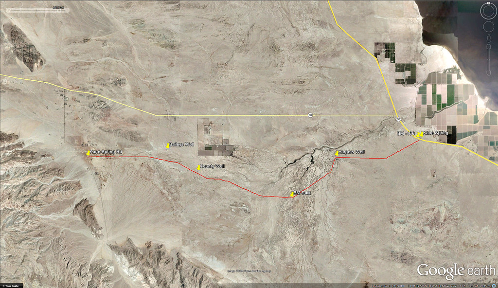
Kane Spring Road by tomteske, on Flickr
|
|
|
link
|
|
AdventureGraham Posts: 170
10/14/2013
|
tommy750 wrote:
BorregoWrangler wrote:
tommy750 wrote:
Nice trip! Did you see anything at Harpers Well or Kane Spring? Tom
I don't think I traveled that part of Old Kane Springs Road. Harpers Well and Kane Spring are east of Split Mountain Road, right?
Yes, you're right. Have never been on it. Looks like the part east of Split Mt. Rd is pretty sketchy or nonexistent when looking at GE. Not sure of the boundaries of San Sebastian Marsh/San Felipe Creek ACEC (BLM website down) but they probably preclude anything but a walk through that portion. Looks like you can catch the far east part off 86, though. Tom
Kane Spring Road by tomteske, on Flickr
Thanks for posting that. From what I've been able to find, Old Kane Springs Road marks the boundary of the ACEC. So you can travel along the route that you highlighted in red. At Harpers Well there's a toppled wall along the wash that used to prevent erosion. About 12 feet of the old well casing has been exposed and toppled, now laying on the sand bar. One of these day I'll need to get out there and explore more of that area.
|
|
|
link
|
|
tommy750 Posts: 1040
10/14/2013
|
BorregoWrangler wrote:
tommy750 wrote:
BorregoWrangler wrote:
tommy750 wrote:
Nice trip! Did you see anything at Harpers Well or Kane Spring? Tom
I don't think I traveled that part of Old Kane Springs Road. Harpers Well and Kane Spring are east of Split Mountain Road, right?
Yes, you're right. Have never been on it. Looks like the part east of Split Mt. Rd is pretty sketchy or nonexistent when looking at GE. Not sure of the boundaries of San Sebastian Marsh/San Felipe Creek ACEC (BLM website down) but they probably preclude anything but a walk through that portion. Looks like you can catch the far east part off 86, though. Tom
Thanks for posting that. From what I've been able to find, Old Kane Springs Road marks the boundary of the ACEC. So you can travel along the route that you highlighted in red. At Harpers Well there's a toppled wall along the wash that used to prevent erosion. About 12 feet of the old well casing has been exposed and toppled, now laying on the sand bar. One of these day I'll need to get out there and explore more of that area.
I agree, looks like a fun place to check out. Tom
|
|
|
link
|