5/13/2015
Topic:
Carrizo Marsh
dsefcikAdministrator
|
Not sure what area you are referring to that is closed. There is tamarisk removal efforts and stage station rebuilding efforts in progress. They have been working on Carrizo Gorge for a couple of years now, it is pretty cleared out.
I think the CIA is closed for obvious reasons not related to tamarisk. |
5/13/2015
Topic:
Canebrake Canyon Access
dsefcikAdministrator
|
Canebrake Jeff wrote:
The owner of the Crawford ranch, Larry, died in the summer of 2013. It went up for sale in the early fall of that year. Unfortunately the Anza Borrego Foundation was not interested in buying the property. Between October and December of 2013, the canyon was open to hikers with permission to cross Canebrake. The new owners have since closed all access, fixed the road up the canyon and built a helicopter pad among other things. They now come and go by private helicopter. You must be referring to access from the S2, Canebrake is easily accessible from other routes. |
5/13/2015
Topic:
Carrizo Marsh
dsefcikAdministrator
|
Canebrake Jeff wrote:
Then some idiot was digging for scrap metal and got hurt. There is still plenty of ground level un-exploded ordinance out there. They have to close it for that obvious reason combined with today's litigation crazy society. It is definitely one of the most beautiful parts of the desert and I personally hope to see open again some day. |
5/13/2015
Topic:
Carrizo Marsh
dsefcikAdministrator
|
Canebrake Jeff wrote:
The marsh is closed by order of Kathy Dice, 1 mile east of the Vallecito/Canyon Sin Nombre jct. No word on when it will reopen. I'll check it out next week. Let me see what I can find out, was not aware they were keeping it closed. |
5/14/2015
Topic:
Carrizo Marsh
dsefcikAdministrator
|
Seems it has no immediate re-open date. It will remain closed to public access for the duration of tamarisk removal and habitat restoration.
-- |
5/15/2015
Topic:
Cuyamacas Day Hike
dsefcikAdministrator
|
Great photos Tom, the snake was fun...he made a hell of rattle sound as he slithered down into the rocks. It was a peaceful and quiet day hiking in the mountains, a nice change of pace. I didn't take too many photos and I am still practicing my analog to digital skills...
Japacha & Cuyamaca Peaks

Tom in an open meadow

Total Mylar Balloons - (-4) they were way off in a tree and I did not go get them....
-- |
5/17/2015
Topic:
Bighorn Sheep Count 2015 Volunteers Needed !!
dsefcikAdministrator
|
The 2015 BHS Count Signup Sheet is attached to this post. If you have ever thought about participating in the Bighorn Sheep Count this is your chance!


-- |
5/19/2015
Topic:
Bighorn Sheep Count 2015 Volunteers Needed !!
dsefcikAdministrator
|
Would be great if you could make this year Buford, at least to give it a try...! Go the meeting and you can decide if it is for you or not. |
5/21/2015
Topic:
Bighorn Sheep Count 2015 Volunteers Needed !!
dsefcikAdministrator
|
For any potential counters, if this will be your first year counting the June 20th meeting is mandatory. It is a great meeting and returning counters pretty much always go every year also. I won't be at the meeting this year though as I am planning a Sierras bcackpack trip that week so hopefully I will have a chance to meet any of you on the count dispersal date. Thanks for your counting support..!!  |
5/28/2015
Topic:
Coyote Canyon camping
dsefcikAdministrator
|
Were there any other people out and about? Sounds like the bypass is not too bad right now. I need to post something up from last weekend, hopefully in the next couple of days. |
5/28/2015
Topic:
A few familiar places we enjoyed in May
dsefcikAdministrator
|
Those pilings/bollards at the fish creek mtns trestle are new, I don't remember those...damn that's muddy. Great TR, kids are getting big...the desert last weekend was awesome, I too went home to cold temps after being warm all weekend. Your rig is parked where Gary has his truck, we were out of there by 9am. I need to post a TR on our backpack trip..
Oh yeah, smoke trees seem to be big and bright this season, you got some good pics of them... |
5/31/2015
Topic:
Carrizo Gorge Wilderness Backpack
dsefcikAdministrator
|
Gary and I spent the long 3 day Memorial Day weekend leisurely traversing the Carrizo Gorge Wilderness with no more of an agenda other than getting back to our trucks sometime by the end of the day Monday. Mr Tom was kind enough to drop us off at Jacumba on Sat morning and was going to hike with us for the day but the weather was kinda cold and blustery and I guess his jacuzzi and booze back home sounded better so it was just Gary and I.
Carrizo Gorge is one of those easy to get to wilderness areas that just never gets old and it has a long history with the railroad and the now famous Goat Canyon Trestle. The trestle seems to be growing exponentially in popularity and I suspect that will continue until the railway patrols pickup again. This particular trip we saw as many as 10 motorcycle adventurers in addition to all of the usual hikers and MTB'ers.
There is something about the Gorge that seems to beckon film photography and I always enjoy taking at least one older analog camera with me. The B/W photos here are from my Fuji GW690 6x9 medium format camera and the film is Fuji Acros 100 developed 1+2+100 in PMK Pyro @13 minutes. A few of the photos I took were an attempt to mirror photos found in the The Impossible Railroad book.
Carrizo Gorge with Sombrero Peak way off in the distance to the right

Following the tracks, some of the trestles are in good shape, others not so much

One particular set of railway cars that has been out on the tracks for several years now has been heavily vandalized.

On page 36 of The Impossible Railroad book there is a picture showing the Young & Crooks Camp 1 and all of the workers tents and the compressor plant equipment. This is the roughly the same photograph but the only thing you can still see are foundations of cement and many of the cleared areas that were built up with rocks to form a tiered foundation for the large tents they used

Gary at a few of the railroad camps

This workers camp overlooks the gorge and has approx 5-6 built up tiers for large tents. Most of it is overgrown with cholla now though.


Here is another photo from The Impossible Railroad book
on page 40 showing tunnel 15 where they eventually gave up on that tunnel and built the tracks around it

We found a huge horseshoe, looked more decorative than useful

This is one of the cooler tunnels out there

Gary heading into tunnel 16, this one has a history of fires and collapses which is evidenced by the tweak on the top. The inside supports you see in the other tunnels are missing which I am guessing is from the 1986 fire that burned it out

What would a trip thru the Gorge be without a photo of the Trestle

Eventually we found our way to the East Fork and the Carrizo Palms. There was some water and lots of wildlife tracks

Unfortunately this poor gal was not able to make it to the water source. I was able to go out a few days later with a Fish & Game Biologist to perform a post-mortem and the cause of death was determined to be from disease

Rock Art

I did manage to get some digital shots as well, love the sunrise photos with a super zoom

The Goat Canyon Trestle has several "catwalks" built in to facilitate repairs and maintenance duties and there is also an elaborate fire supression system built into the trestle with many pipes and valves that lead up to the water tanker on the hillside above. This photo is looking straight thru the first catwalk and some of the water pipes are visible. I can't recommend walking these catwalks at all, they are sketchy at best

Gary enjoying some of the water at Carrizo Palms

Reptiles were out and about, we found 2 in the same spot with head injuries, pretty strange, anybody have any ideas? We were thinking hawks or such


This guy was chilling in the shade of the tunnels

Railroad camp debris, re-purposing a shovel for something?

This is more my speed, a real fifth bottle of whisky

Anyways, thanks for reading, hope you enjoyed...time to turn in.....

----- |
5/31/2015
Topic:
Carrizo Gorge Wilderness Backpack
dsefcikAdministrator
|
surfponto wrote:
Mary and I were out in Jojoba Wash on Saturday for the night.
Super windy. How was it just sleeping in your bags on the ground with the wind?
We had the luxury of the rooftop tent  Pretty sucky as was Sunday morning....cholla kept blowing into my head, we slept on a ridge Sat night with "gorge"ous views but windy and tons of cholla balls. Wish I knew you guys were out, we need to hike again, it's been awhile. |
5/31/2015
Topic:
Coyote Canyon camping
dsefcikAdministrator
|
Borregolinda wrote:
We were all the way up to Sheep Canyon Thursday doing our clean up. The bypass road is not as rough as it was years ago. But rougher than the last time we were up earlier this year. Need a little bit of thinking to get up it but not bad. A 2wd SUV isn't going to make it! Thanks for that update Borregolinda, road will be closed for awhile now, hopefully I can get out there when it opens up again. |
5/31/2015
Topic:
A few familiar places we enjoyed in May
dsefcikAdministrator
|
When I had my Dodge I would beat it up pretty good but I can't remember ever using it as the backstop for batting practice....guess you guys couldn't get way from baseball that weekend after all... |
5/31/2015
Topic:
Carrizo Gorge Wilderness Backpack
dsefcikAdministrator
|
We did also see a grey fox towards the end of the day Sat as we were scouting a place to camp for the night. He was near the 2 dead snakes. Not sure if he was checking them out or responsible for them. Ziphius..?? |
5/31/2015
Topic:
Carrizo Gorge Wilderness Backpack
dsefcikAdministrator
|
Jim (ziphius) wrote:
I like the medium format photos Daren. Gosh, my first guess with the snakes is that they were mating and got interrupted. If you watch video of their mating ritual, their heads end up intertwined and the 2 snakes combined are not very mobile at that point. Maybe your fox came by and chomped on both of their heads at the same time. Otherwise, it's hard to catch 2 snakes at once and chomp their heads...they look like coachwhips / racers? ...which are pretty fast. I like your theory...very plausible...yes, racers I think also... |
5/31/2015
Topic:
Carrizo Gorge Wilderness Backpack
dsefcikAdministrator
|
tommy750 wrote:
Nice trip, Daren. Wish I could have joined you especially since when I went back home, ended up eating bad takeout and was sick all week Looks less cloudy than I thought. Pics look really nice when you click on them and get a larger size. So the necropsy showed "disease"?? Any more specific? Gonna take some of the negs to the enlarger tonight...we'll see how they print...as for the ewe, official report shows "nonpredation – chronic sinusitis"....most likely a barrel cactus spine (or two) got stuck in one of the horns and caused a long history of infection, apparently common in sheep. |
5/31/2015
Topic:
Overnight backpack north of Wilson Peak
dsefcikAdministrator
|
Desert season is starting....you should sign up for the sheep count..!! |
5/31/2015
Topic:
A few familiar places we enjoyed in May
dsefcikAdministrator
|
tommy750 wrote:
Looks like a nice time out, Nolan. There's a bunch of markers on the west side of E085 related to the bombing range. I think that tall sign is one of them. Here's a couple other ones presumably guiding planes to specific targets: Tom....you moved those didn't you..??  |
5/31/2015
Topic:
A few familiar places we enjoyed in May
dsefcikAdministrator
|
tommy750 wrote:
With my bare hands! Actually, looking at GE you can see what they're about. Didn't realize it when I was out there a couple years ago but they're 5,000 ft markers heading toward a target tank. I only saw the 20K and 30K markers but they're all still out there and visible on GE.
.....  |
6/1/2015
Topic:
Carrizo Gorge Wilderness Backpack
dsefcikAdministrator
|
Canebrake Jeff wrote:
The Coachwhips look like they were killed by a human with a rock. A predator would have eaten its kill. All the animals out there are hungry. Given the location, general environment and that they were not smashed at all, just bloody with holes in the head laying next to each other I am not thinking that is likely...when we came around the bend a fox took off running from the general location. We saw no signs or evidence of people anywhere in that location. |
6/2/2015
Topic:
Carrizo Gorge Wilderness Backpack
dsefcikAdministrator
|
tommy750 wrote:
Daren, you might want to contact the California Herps guy regarding the weird snake kill. Thanks Tom, I sent the photos to him..will post back with anything he may say. |
6/2/2015
Topic:
Bighorn Sheep Count 2015 Volunteers Needed !!
dsefcikAdministrator
|
Jim (ziphius) wrote:
Thinking about this year, I'm already planning a mid-June trip to Big / Middle Spr. area as a test run of my summer heat tolerance. I know you guys lug in all your water into Rattlesnake ahead of time in the spring. What about tarps? Are they something you need to provide or does the park provide those? Rattlesnake is the only place that requires us to cache water, all other count sites you bring it in each day you go or there is water available to filter. The park does not provide tarps or shade shelters, counters typically will divide count site needs among themselves. The pre count meeting is essential for questions like this. |
6/2/2015
Topic:
Carrizo Gorge Wilderness Backpack
dsefcikAdministrator
|
dsefcik wrote:
tommy750 wrote:
Daren, you might want to contact the California Herps guy regarding the weird snake kill. Thanks Tom, I sent the photos to him..will post back with anything he may say. Gary's first thought mirrored ziphius..he also suggested what canebrake jeff said....so anyone's guess but I suspect the mating idea is probably correct since I doubt anyone was near the area we saw them and the fox was coincidentally present. |
6/4/2015
Topic:
Bighorn Sheep Count 2015 Volunteers Needed !!
dsefcikAdministrator
|
Buford wrote:
I signed up. Looking forward to June 20th and the 4th of July weekend. Hope to see you out there! |
6/8/2015
Topic:
from rockhouse ruins to cactus springs trail
dsefcikAdministrator
|
I have not been on the Cactus Springs Trail but there is a finger just east of the Old Santa Rosa Village you can ascend that will put you up near Martinez Cyn near peak 5668. There is an old Indian trail you can follow up. On the topo for RHC find quad 16 and the finger to ascend is almost right underneath the number 16. Head up the canyon on the west side of the quad 16 ridge (side with 4600 on the contours) a 1/4 mile or so and you will see the trail up. I am guessing from there you can descend down to the Cactus Spring trail. From Cottonwood Spring just stay up on the alluvial's avoiding any constant up/down thru the dips and head towards the base of the mountains, there you will find an Indian trail that hugs the base of the mountains and can take you to the finger I mention.
-- |
6/8/2015
Topic:
from rockhouse ruins to cactus springs trail
dsefcikAdministrator
|
BTW, if you want any company let me know, I wouldn't mind doing that trip also. |
6/8/2015
Topic:
from rockhouse ruins to cactus springs trail
dsefcikAdministrator
|
BTW,BTW...Welcome to the forums...!!.... |
6/11/2015
Topic:
Santa Rosa Traverse in One Day-unsupported
dsefcikAdministrator
|
Definitely enjoyed reading the posts on your site. I will 110% agree with what happens after Rabbit and the false summit, that one took 1,000' out of my trip to get around. I thought I recognized Cappy...been too long since I was UR, good to see you guys still out there. Maybe we can try for RHC again when your up for it. |
6/11/2015
Topic:
Carrizo Gorge Wilderness Backpack
dsefcikAdministrator
|
ImpatientHiker wrote:
Hi Daren, your pictures are so good and you take so many. I wonder, do you display many around your home? Do you change them out? Do you do any framing yourself? Thanks for the compliments, much appreciate...can't say I do much of anything with them other than let people see them on the web. I just enjoy the process of it all and film has given me even more of a challenged process but more importantly film has given Tom something he can poke fun at me with every trip....
I have just recently starting doing prints in my garage/darkroom, they are really nice compared to inkjet printing and you can totally control how the print looks with dodging & burning.
I am happy to give my photos to anyone who wants to use them for personal use...better than just sitting on my computer buried away.
-- |
6/11/2015
Topic:
Carrizo Gorge Wilderness Backpack
dsefcikAdministrator
|
Florian wrote:
Those two dead snakes are very odd. Is that how you found them beside each other? Yesterday hiking near Palm Springs i came across a young king snake cut into 2" pieces. Weird. Yes, that is how I found them....I would go with canebrake jeff's theory on yours and probably ziphius's theory with mine....just MHO... |
6/21/2015
Topic:
Borrego Springs 1965
dsefcikAdministrator
|
AWESOME...!!....
These are great, please post anymore you may have, I love old photos... |
6/21/2015
Topic:
Santa Rosa Traverse in One Day-unsupported
dsefcikAdministrator
|
I am just getting back from a long backpack trip in the Sierras so I am a little late catching up on all the posts. Your trip was awesome to read thru, if anything I posted was helpful for your trip I am happy. I know I lost/gained something like 700' on the last chunk getting to Dawns, the manzanita was so thick there was no getting thru it.
Reading thru this TR makes me want to go back out there....soon..!! |
6/21/2015
Topic:
from rockhouse ruins to cactus springs trail
dsefcikAdministrator
|
More great old photos from rockhopper...!
Will probably start looking at this trip when the weather is more accommodating, right now just getting geared up for 4 days at Rattlesnake to count sheep. |
6/21/2015
Topic:
Montezuma Grade during the heat wave
dsefcikAdministrator
|
Tell Rich great photos...!
Yep, getting ready to spend 4 days at Rattlesnake for the annual BHS count, only a couple more weeks...seems like you got a taste of what it is like. |
6/22/2015
Topic:
Borrego Springs 1965
dsefcikAdministrator
|
ImpatientHiker wrote:
See the white chevron behind the little white hill on the top of the ridge to the right of your mom? AKA "The Necklace"...that is a straight drop down from there....does look like Butler junction, nice call IH.
ImpatientHiker wrote:
Here's a pic of my grandparents in Borrego in the late thirties. I am definitely not hiking in the right clothing! Please comment if anybody recognizes the location.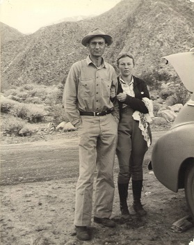 Can't say there is enough for me to recognize it but those are some cool clothes..!! |
6/23/2015
Topic:
Carrizo Gorge Wilderness Backpack
dsefcikAdministrator
|
tommy750 wrote:
Think I just figured out the dead snake mystery! Make sure you read the entire article.
https://www.thedodo.com/mother-rabbit-attacks-snake-1211670128.html 
--
Nice find Tom.... |
6/27/2015
Topic:
Rocky Basin Lakes 7 Day Backpack in the Sierras
dsefcikAdministrator
|
One thing I learned on this trip is I need to pay more attention to my route planning when it comes to ascents and descents. I showed Gary the map of where I planned our route and he looked at and said...looks good but we probably should go in reverse order, that would save us from going up hill all this way and on the way back would be a lot easier since we probably won’t find water in any of these creeks since everything is so dry right now...dry in June in the Sierras?? Yep, pretty damn dry, water was scarce enough that we had to plan our days to make sure we had water. And it turns out Gary was right (as always) and 2 days were dry until we made camp at the end of the day.
We started at the Schaeffer Meadow trail in Monache Meadow and did a figure 8 loop going up to Rocky Basin Lakes and back. Water was available enough thru Templeton and Ramshaw Meadows but dry on the trail to Rocky Basin Lakes from Tunnel Meadows. It was also dry from Rocky Basin Lakes all the way down Johnson Creek to Salt Lick Meadow, where Johnson Creek splits and the trail crosses the creek there is good water. The trail up from Salt Lick is a bit tricky to follow for a few miles from lots of downed trees as there doesn’t seem to be much trail maintenance happening. Luckily Gary was smart enough to make sure we came *down* the Johnson Creek trail and not up like I had planned.
Here is the southern portion of our figure 8 route

Here is the northern portion

Caltopo gave me a profile of our route. I did not track the trip but instead drew it up on Caltopo as close as possible to the marked trails. While it was off in a few places it is amazing how accurate it is on the GPS, I did bring a GPS and pretty much used it only to amuse myself and for a few areas where we lost the trail big time.

This trip I took 3 Cameras, a 4x5 sheet film cigar box pinhole camera I made recently, my waist belt holstered Canon S95 point ‘n shoot and a recently acquired Fuji GA645W medium format film camera. The pinhole camera stayed in the truck and I only took a few pictures with it when we were car camping. I have been using B/W film on almost all my trips for the last year or so and it is kinda growing on me. I have recently started doing prints with an enlarger in the darkroom and that has been a lot of fun, learning how to Dodge & Burn with my hands and pieces of cardboard. I am really happy with the film photos from this trip, I used Ilford HP5 Plus 400 and developed it in Formulary PMK Pyro.
I originally had some really long lenses, a tripod and my Fuji X-E1 in my pack thinking it would be good for wildlife but the weight of a 600mm lens, it's carry case and a tripod was more weight than I wanted to carry so it stayed home. Turns out it would have been great to have as we saw 2 bears, deer, marmots, coyotes and many birds all close enough to fill a 600mm lens frame. Ended up having to use the Canon S95 to zoom in on the distance wildlife so the pictures are not that great.
On the road into Blackrock just before the Monache Trail this sign was worked into a Bigfoot Crossing, I thought it was kinda cool

Here is where we started the trip down in Monache Meadow

There were many great meadow views and the first day we had lots of puffy big white clouds but that didn't last any longer than one day. Here is Schaeffer Meadow with Templeton Mtn in the distance

In no particular other order here are some other photos from the trip, B/W is medium format Ilford HP5 Plus film, color is noted as either digital from the Canon S95 or Vevlvia 50 film although I think the difference between the Velvia 50 and the digital is somewhat obvious.
Gary at the Snow Survey Cabin in Little whitney Meadow

Snow Survey Cabin Horse Shoe Station


Dragon Outhouse

Trail Cross Roads

Lower Salmon Creek Falls

Rocky Basin Lakes - #25A Filter and Polarizer

Rocky Basin Lakes Evening Shadows

At the top of Red Hill you can look down thru Ramshaw Meadows and see Olancha Peak off in the distance. Olancha & Kern Peaks are prominent landscape features in the southern Sierra range

According to the topo map this is Rocky Basin Lake WL 10802T, the west'ish most lake of the bunch

There many burned out tress in the Sierras and many have some stunning colors and patterns, here is one I tried to be artsy with but probably failed at since it really is not in my blood to be artsy

Handing the camera over to Gary you get a rarely seen photograph of yours truly in a uniquely split tree trunk

One of the teachers where I work did a project with cigar boxes and had a few left over so I built a 4x5 sheet film pinhole camera out of one of them and took it on the trip with us but only for car camping. We stopped at Sherman Pass and it was a cloudy, windy and just about to be rainy day. I set up the pinhole camera and guessed at a 1.5 minute long exposure, here is the result...not bad for a small hole in a box

Here is another I took on the last morning of our trip in Monache Meadow before we drove off

The last day of our trip I put a roll of Fuji Velvia 50 slide film in the Fuji GA645W camera. I was skeptical of how it would turn out and I knew it wouldn't be cheap to get just one roll developed but my curiosity won my wallet over. I have to say, looking at the color slide film on a light table with a loupe is just amazing, the transparencies are razor sharp and almost 3D like with amazing colors. The scanned B/W negatives and transparency photographs really do not do justice to the actual film photographs, the film is just so sharp and beautiful to look at that the scanned images are almost painful to show you....but I am gonna do it anyway....
Here is the sunrise in Strawberry Meadows (Fuji Velvia 50)

The Schaeffer Meadow Trail Sign, I have a B/W version in the beginning of this TR for a comparison (Fuji Velvia 50)

Here is Gary on the boulders overlooking the Kern River near Strawberry Meadows, this was my most favorite place in the whole trip, I could spend days there. The colors of the film photographs to me have a kind of visual appeal I just don't get in the digital photographs..not sure how to really define it though, maybe just nostalgia, childhood memories of waiting for Thrifty's to develop my film..not sure but I do like it. (Fuji Velvia 50)

Brown Cow Camp, it was pretty run down, it has not been used in awhile (Fuji Velvia 50)

Kern River in Strawberry Meadows (Fuji Velvia 50)


Here is a west view of Strawberry Meadows with Kern Peak way off in the far distance and a Marmot perched on the boulder in front of me (Fuji Velvia 50)

Kern River flowing south down towards Monache

The rest of the photos here are from the Canon S95 digital camera, a fine little 8oz camera.
Small yellow flowers like this bloomed for 2-3 days before all dying off

We had several Marmots check us out at various parts of the trip


We also saw 2 definite bears grazing in the meadows and 2 more we believe at sundown but it was getting dark so we could not be certain.
Looks like bear tracks

Looks like bear crap

Must be bears....


The last bear we saw was about 1/4 mile away from where we setup camp so we were extra careful about hanging our food really high

We crossed paths with deer a few times also

We spent quite a few hours hanging out by the Kern River watching the Golden Trout swim by and every now and then there would be some pretty cool reflections

Gary and I share the same cultural and historical interests and we are always looking for signs of the past in our backcountry excursions. The Sierras were also home to Native Americans and evidence of their habitation can be found if you look close enough


This was another great backpack trip with Gary and I hope you enjoy the photographs as much as I enjoyed taking them.
Total Balloons this trip - 3 (1 mylar + 2 latex) Sorry, no photos
http://www.sefcik.com/2015/06/rocky-basin-lakes-7-day-backpack-in.html
-- |
6/28/2015
Topic:
Bighorn Sheep Count 2015 Volunteers Needed !!
dsefcikAdministrator
|
DesertWRX wrote:
Going back to Yaqui Pass this year. Saw none there last year, but who knows maybe we missed them by a day. You never know..last year was not so good for almost everyone if I remember correct....maybe I will see you at the pickup on Thursday.....glad you are going back out again this year....wasn't Yaqui Pass a new count site last year (or at least one that has not been used in awhile)?? |
6/28/2015
Topic:
Bighorn Sheep Count 2015 Volunteers Needed !!
dsefcikAdministrator
|
I was actually getting my pack ready just now, have it pretty much done except water and food. Same waist pack as last least year, should be under 20lbs total after I add water/food. Last year it was 18lbs (pretty sure...) Not bad for 3-1/2 days. |
6/28/2015
Topic:
Rocky Basin Lakes 7 Day Backpack in the Sierras
dsefcikAdministrator
|
tommy750 wrote:
Looking at your BW pics makes me think you have more than a few drops of "artsy" in your blood  I think my drops of artsy come in a 90 proof bottle... |
6/29/2015
Topic:
Rocky Basin Lakes 7 Day Backpack in the Sierras
dsefcikAdministrator
|
surfponto wrote:
Wow when i saw the bear pictures I was freaking, looks closer than a 1/4 mile a way.
Very cool.
Great pics of your adventure. We got as close as 4-500' before either one of them ran off...too close for me and since Gary politely let me go first I was kinda getting nervous as we got closer and closer...we ended up camping maybe a 1/4 mile away from the second bear we saw right where we saw lots of big deer, not those puny little mule deer in the so cal mountains. Bear, Deer and Marmot tracks everywhere...only a few coyote but they were howling all night in Strawberry Meadows. |
6/29/2015
Topic:
Bighorn Sheep Count 2015 Volunteers Needed !!
dsefcikAdministrator
|
Buford wrote:
I got assigned to head up Palm Canyon with a group. Looking forward to it. I saw our site hasn't been counted every year. I also looked at previous counts and thought it was interesting how some years a site has 0 and the next year that site might have 15.
It will be weird to backpack and not worry about cold temps at night. Where did you get assigned, 4th grove? Usually they don't have enough backpackers to count each grove. Yeah, I sleep in a nylon bivy with a mesh screen for the bugs, that's it....1lb for sleep gear plus the pad. |
6/29/2015
Topic:
Baby foxes. Everyone loves those, right?
dsefcikAdministrator
|
All great stuff..I am a sucker for wildlife, love the moth shot for sure... |
6/29/2015
Topic:
Brewing The Foundation For Conservation Event
dsefcikAdministrator
|
Looks like a rough job.....glad somebody has to do it... |
6/30/2015
Topic:
Pacific Imperial Railroad's latest idea
dsefcikAdministrator
|
The Impossible Railroad saga continues, Spreckles would be proud.... |
6/30/2015
Topic:
Baby foxes. Everyone loves those, right?
dsefcikAdministrator
|
tommy750 wrote:
Nice pics Jim! More animals than an Marlin Perkins episode OMG..forgot all about that show.....
 |
7/6/2015
Topic:
Bighorn Sheep Count 2015 Volunteers Needed !!
dsefcikAdministrator
|
Hey Buford, did you go? I was at the maint yard until about 4pm...if you made it out, how was the count? I will post up pics and a TR from our site in the next couple of days. |
7/6/2015
Topic:
Bighorn Sheep Count 2015 Volunteers Needed !!
dsefcikAdministrator
|
Attached to this post is the final 2015 count report, I will post up some pics in the next few days.
Thank you to anyone who participated in this years count, the flies and bees were awful for everyone I am hearing.
--
edited by dsefcik on 7/6/2015 |
7/6/2015
Topic:
Sheep Count 2015
dsefcikAdministrator
|
Great report Buford...I will write something up for our site in the next few days.
You never know what you will see during the sheep count, you may get tons of sheep or you may get none. This year was not particularly hot so my guess is they were not out looking for water as much but I am no expert. I totally understand the frustration and boredom of sitting around all day and not seeing any sheep, my first count we saw a few sheep and many were already counted by a group below us. I hope your experience was positive enough to sign up again next year but totally understand if not, this event just isn't for anyone which I am sure you now understand much better.
I am wondering why your 7pm sighting did not count, did Steve specifically say that? |
7/6/2015
Topic:
Sheep Count 2015
dsefcikAdministrator
|
Buford wrote:
I thought the bugs might be an issue. At worse, they were a minor annoyance. Interesting, we had so many flies and bees it was really, really bothersome, we used mosquito nets some of the day to keep them off us and one of our counters was stung several times. Glad to hear you did not have to experience this. |
7/7/2015
Topic:
Sheep Count 2015
dsefcikAdministrator
|
surfponto wrote:
Was all set to do it next year until I heard about Daren's bee encounter  You seem to threaten doing it all the time but never go...will next year be for real?? |
7/7/2015
Topic:
Sheep Count 2015
dsefcikAdministrator
|
I have too many photos to post, you can see all of them here:
http://www.darensefcik.com/Photography/Anza-Borrego-Desert-State-Park/Bighorn-Sheep-Count-2015/50432774_DV9dvK
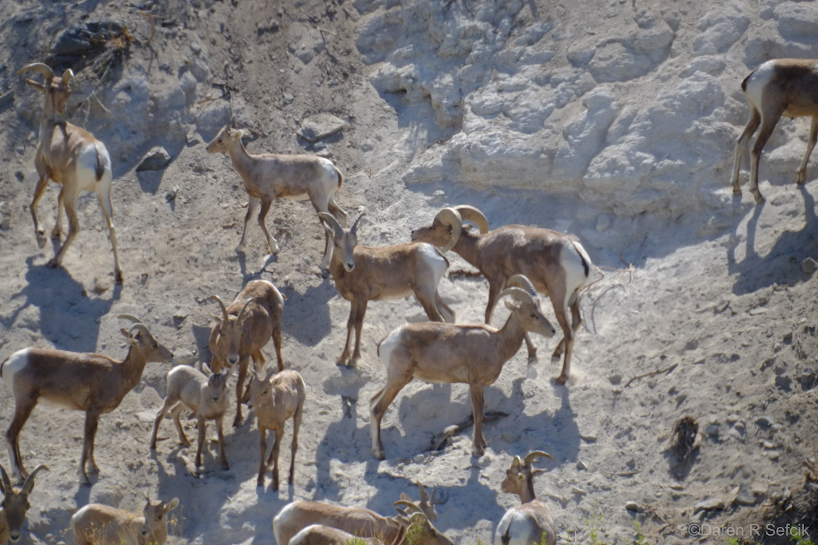
I have been counting at Rattlesnake Spring for the last 4 years, before that I counted at Upper HellHole Canyon. Rattlesnake Spring usually has more sheep than the other count sites but is also considered the most difficult site to count at. We backpack in and out during the evening hours and catch the shadows of sunset and the dark of the night. Because of this we also count 3 full days instead of the usual 2-1/2 days. During the Spring we will make one or more trips carrying water up to the site and burying it so we have water to drink during the count, we do not drink from the spring. The result of all of this is we get to see many sheep that others do not. This year we had a total of 73 unique sheep and too many flies and bees to count The weather was especially nice compared to previous years. All in all a good count this year.
We are not particularly close to the sheep when we count, I used a 600mm lens this trip for most of the pictures. Binoculars and a spotting scope are a must for us to accurately count and identify the sheep. The camera and 600mm lens helps us to identify repeat sheep. This especially difficult if they come back in a large group of twenty or more.
Here is our count site as seen from the spring where the sheep drink


-- |
7/7/2015
Topic:
Sheep Count 2015
dsefcikAdministrator
|
Jim (ziphius) wrote:
Great photos Daren. Congrats on another year. With that many sheep, you guys gotta be on your toes to sort them all out and ID them. What were the longest periods during the day without sheep at the spring? Was your team 3 or 4 people? 4 people this year, we were breaking in a new guy to replace Gary, he retiring, this was his last year. Each day is different, some days we have action from 6am to 7pm, others we have dead times all day and it is extremely boring and then 30-40 will all come down and dance around the water, then it gets tough to sort out. I guess unlike the other count sites, we have nobody else to contend with for seeing the same sheep and we count from sunrise to sunset, ain't nothing else to do. |
7/7/2015
Topic:
Sheep Count 2015
dsefcikAdministrator
|
surfponto wrote:
I was tripping on the closeup shots of the flies Those were the small ones, billions of them...also had a few white crickets


-- |
7/9/2015
Topic:
Sheep Count 2015
dsefcikAdministrator
|
DesertWRX wrote:
We were at Yaqui Pass. Pretty deluxe spot, but saw only 1 sheep, a ewe missing her right horn. Saw her Fri and Sat morning. But how many cold beer bottles did you get to see everyday?? I know for me none....
Thanks for hanging in there, maybe next year you will get lots of sheep.... |
7/12/2015
Topic:
Culp Valley
dsefcikAdministrator
|
Welcome to the forums!
Those cans I would suspect are from the Paroli Homestaed era, last I remember they were near that cave. The black bird can be heard and seen almost everywhere in the park, zipius will correct me but I think it is the Phainopepla and anybody who hikes with me will know how off key I am trying to mimic their call...
Curious about the eggs and nest, was that on the ground, how big?
Where the hell is that damn graffiti? I haven't seen any out there in awhile unless it is near the campground, I haven't been over there in a few years. |
7/22/2015
Topic:
Perseid meteor shower this weekend
dsefcikAdministrator
|
absolemn wrote:
Troutbum wrote:
Thanks! Will do.
I'm thinking of doing the exact same thing. Hi, I'm new to this site and I created an account just to comment on this. How did it go? How was the weather? We wrote a trip report here http://www.anzaborrego.net/anzaborrego/forum/topic317-perseid-meteor-shower-.aspx |
7/23/2015
Topic:
Perseid meteor shower this weekend
dsefcikAdministrator
|
tommy750 wrote:
I still remember that night. We almost missed meeting Daren for the first time since he apparently passed out after a long hike with his buddies Jose and Jack Little did I know Tom and I would end up becoming friends and hiking/backpacking all the time now... |
7/24/2015
Topic:
Perseid meteor shower this weekend
dsefcikAdministrator
|
Thanks for the advance notice rockhopper, according to earthsky it is happening the 11th-13th of August.
I have marked my calendar, Tom...can I ask you out on another date..??  |
7/27/2015
Topic:
Blair Valley
dsefcikAdministrator
|
You can see the wind turbines from just about everywhere. At Rattlesnake Spring this last July 4th we could see the ones recently built in Mexico also, at night we could just see red blinking lights all to the south. I am sure the views up on higher ridges like Rabbit see it all. |
7/28/2015
Topic:
The Potrero
dsefcikAdministrator
|
yeah froggies...!! we had to leave some reeds for them...looks like my pipe prop was still holding up also...thanks for the photos Tom and my pack is still sitting in the garage ready to go minus the food I ate from it last week.
Love that B/W pano, really nice..!! |
7/29/2015
Topic:
The Potrero
dsefcikAdministrator
|
trail cam?? any photos of that? never seen a cam out there. |
7/29/2015
Topic:
The Potrero
dsefcikAdministrator
|
either CDFW, BP or illegal hunters would be my guess..but CDFW sounds most likely...never seen a cam there before. |
7/30/2015
Topic:
The Potrero
dsefcikAdministrator
|
Nolan (anutami) wrote:
What the heck were all the frogs doing on your tent? Obviously you have never gone backpacking with Tom.... |
7/30/2015
Topic:
Summer of 2015
dsefcikAdministrator
|
You drilled thru leaf springs with a cordless drill..??? OK, you are bad ass....
I have so may Ansel Adams books on my desk right now that your El Cap photo fit right in to my current library. Nice trip, once again totally jealous...wish I was your kid...
You know, I thought your daughter was strong when you posted that pic of her with that portable mortero once but this TR with her holding that huge truck wheel in the river is amazing...just amazing....
Amazing TR, just amazing..wishing I was there with you..thanks for sharing all that.
Daren |
7/30/2015
Topic:
The Potrero
dsefcikAdministrator
|
tommy750 wrote:
Actually, a bunch of them would jump on the tent and climb to the top and jump off. Leap...Frog ?? |
7/30/2015
Topic:
The Potrero
dsefcikAdministrator
|
Peace Out.... |
8/2/2015
Topic:
The Potrero
dsefcikAdministrator
|
I can vouch for 2 of the springs...I still have to investigate the 3rd most southern one.


-- |
8/3/2015
Topic:
The Potrero
dsefcikAdministrator
|
tommy750 wrote:
surfponto wrote:
I second what Nolan said about you heading out in the warmer months.....
Daren and I had some more fourth season fun this past weekend out in McCain Valley. The weather service said it was going to be only 84/69 degrees but ended up about ten degrees hotter. And no luxurious spring nearby to tap for an extra liter or three! Tom, you gonna start a TR for it? It was damn hot and the In-Ko-Pah mountains are steep coming back up..! |
8/3/2015
Topic:
Jamul Kiln Ruins
dsefcikAdministrator
|
So I wanted to check this site out Sunday and after a bit of research it was clear that it is NOT open to the public at all. The CDFW website for the Ecological Reserve in Jamul is very clear and it states Hours: The reserve is only open for special events.
I drove out and took a look around, there is no easy place to park and no welcoming visitor trail head signs, instead you will find fence line in all directions and No Trespassing signs posted everywhere alongside the Ecological Reserve signs. I can't vouch for when BW visited the site but I can say for certain now it is definitely off limits to the public. |
8/3/2015
Topic:
Jamul Kiln Ruins
dsefcikAdministrator
|
Nolan (anutami) wrote:
Daren, your trip out didn't qualify for a "special event"? Every trip report you post is special and such a great event! I will vouch for you anytime I will be sure to let them know, maybe they will let me in now... |
8/6/2015
Topic:
Is Fingertail Spring Dry?
dsefcikAdministrator
|
Nice TR Tom..!!
I never knew it was named Fingertail, you make that up or what..?? I have some photos I still need to develop but I haven't finished the roll yet so I will post some of my own soon...
I brought my 4x5 field camera and do have one shot from that of the cattle trough(s). My shot shows both the older cement water tank and also the newer steel one. Carrizo and the Coyotes of in the distance

A sheet of 4x5 film scanned at 3200dpi is about 181MP and a 2.1GB file...fun...
Had fun Tom, let's do it again sometime... |
8/6/2015
Topic:
Is Fingertail Spring Dry?
dsefcikAdministrator
|
Hey, that's my Invisible Man Rain Dance...almost worked to...!!
tommy750 wrote:
Later that night, someone celebrating the full moon and another desert backpack trip Enjoy. Tom
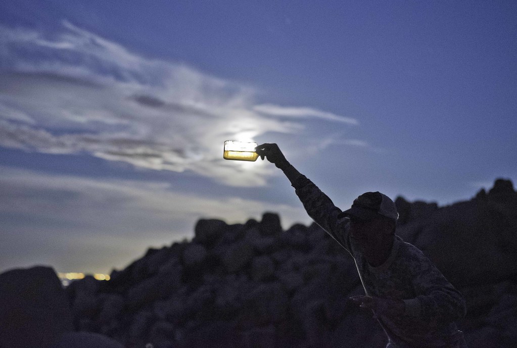 Invisible Man by tomteske, on Flickr Invisible Man by tomteske, on Flickr |
8/6/2015
Topic:
Is Fingertail Spring Dry?
dsefcikAdministrator
|
Which book, Historic Backcountry? maybe it's time I buy it.... |
8/7/2015
Topic:
Diablo Dropoff graded
dsefcikAdministrator
|
The Pinyon Mtn Rd is closed before it gets to the Squeeze, you can't drive thru there anymore. |
8/7/2015
Topic:
Arroyo Tapiado Mud Caves Map?
dsefcikAdministrator
|
The Mud Caves are legit...maps someone may have created to sell are at your own risk I guess. You can just go out there and start poking around, you will find them...especially when there are 5 million other people all parked there and running around. |
8/7/2015
Topic:
Arroyo Tapiado Mud Caves Map?
dsefcikAdministrator
|
sddmarkman619: PM me for more info
--
edited by dsefcik on 8/7/2015 |
8/8/2015
Topic:
Diablo Dropoff graded
dsefcikAdministrator
|
sddarkman619 wrote:
dsefcik wrote:
The Pinyon Mtn Rd is closed before it gets to the Squeeze, you can't drive thru there anymore.
You can't drive the squeeze anymore? why? wow this is the first I've heard of that. Why did they close it?
so I guess the only way to get to split mountain now is from ocotillo wells route? or?
edited by sddarkman619 on 8/8/2015 I drove out Pinyon Mtn rd back around spring break and there are posts up at the pass before you head down into Hapaha Flat, right around where the yellow circle is that Tom drew on his map and where the road ends on the USGS maps. You can get to Split Mtn via Fish Creek / Ocotillo Wells road near the quarry. |
8/10/2015
Topic:
Perseid meteor shower this weekend
dsefcikAdministrator
|
absolemn wrote:
Should I be worried about snakes/scorpions/tarantulas when I camp? Does a zippered tent help? They live out there...but I wouldn't worry about them, just don't bother any snakes you see.
 |
8/10/2015
Topic:
Jamul Kiln Ruins
dsefcikAdministrator
|
Finally developed my roll of film...here is the sign I saw hung all along the fence lines, fairly clear and straight forward, no guess work needed.

-- |
8/12/2015
Topic:
Is Fingertail Spring Dry?
dsefcikAdministrator
|
Finally developed my roll of film so here 'ya go...
The Mastermind behind the whole trip with Sombrero Peak in the distance and Whale Peak way far back

Modern Rock Art in B/W

Tom at the spring


The In-Ko-Pah's have all kinds of really cool shaped boulders


Total Mylar Ballons This Trip - 4

-- |
8/14/2015
Topic:
Is Fingertail Spring Dry?
dsefcikAdministrator
|
tommy750 wrote:
Don't wait too long to get out there cuz Tule Wind is coming soon and things are going to look (and sound) very different afterward.   |
8/18/2015
Topic:
Anza-Borrego Desert Photo Contest 2015
dsefcikAdministrator
|
http://www.theabf.org/anza-borrego-desert-photo-contest
Looks like it is all digital submission this year with a final print send in if qualified and I am not seeing any fees this year either. |
8/21/2015
Topic:
Anza-Borrego Desert Photo Contest 2015
dsefcikAdministrator
|
I would encourage everyone to give it a shot, many of you have posted very nice photos of ABDSP. I could not find anywhere in the submission forms where is was asking for an entry fee like in the past so it seems like it is now free to enter...so why not..??
Looking forward to seeing some great photos of the desert! |
8/21/2015
Topic:
Carrizo Marsh Controlled Burn Today
dsefcikAdministrator
|
http://www.eastcountymagazine.org/prescribed-burn-set-ana-borrego-desert-state-park-today
-- |
8/21/2015
Topic:
Perseid meteor shower this weekend
dsefcikAdministrator
|
Did anybody make it out for the showers? I have been way too busy with work to get away this summer much, I was hoping some other folks may have been able to get out and see the meteors. |
8/25/2015
Topic:
Feinstein seeks new National Monuments
dsefcikAdministrator
|
Didn't see that coming but wouldn't mind seeing it happen....suppose no response is because the land is already spoken for...wind/solar... |
9/1/2015
Topic:
Drone use in the Park
dsefcikAdministrator
|
There are quite a few discussions about drones, privacy etc in public spaces and my guess is they will continue for some time. ABDSP already has regulations that prohibit using them within park boundaries and I am sure rangers will be citing folks as appropriate or giving warnings.
When I was last at Henderson Canyon photographing the Spring Wildflowers there were 2 drones flying around and yeah, it was very annoying.
Teachers and students at the school where I work fly them around the park nearby and do some pretty cool work with the engineering and photography from them.
I have been at the beach and had them buzz me over and over and over again and I could never see who was flying them...again, very annoying.
They have their place and time, I think they are cool...just not everywhere at any time.
ABDSP is one the few remaining places that is free and open for so much to do outdoor related, I would hate to see it turn into another NP requiring gated entrances and visitation fees.
Lets keep the drones home for now..... |
9/11/2015
Topic:
Itching to get out in the desert
dsefcikAdministrator
|
Good find....Mission Trails has some unique "Cuyamaca Ovals" which are rare in the desert areas. It has been hot lately, Tom and I got out to McCain Valley last weekend over labor day, found Thunder Cyn but it was nothing spectacular without roping down in. |
9/11/2015
Topic:
Itching to get out in the desert
dsefcikAdministrator
|
Jim (ziphius) wrote:
a screening of the film Impossible Railroad will take place on 17 September at the Museum of Contemporary Art in downtown San Diego. I might go check it out. Thanks for the heads up...I put it on my calendar. |
9/11/2015
Topic:
Itching to get out in the desert
dsefcikAdministrator
|
Well...it was **a** entrance, the real one is nearby...I think that headlamp makes me look fat....
tommy750 wrote:
Here's Daren checking out a possible entrance to Thunder Canyon:
 |
9/20/2015
Topic:
Carrizo Creek to Carrizo Stagecoach Station
dsefcikAdministrator
|
orion13213 wrote:
I read there was a caretaker / manager of this stage station stage many hundreds of years ago, who murdered his common law Native American wife. He then disappeared, some say avenged by her relatives, others say he fled east.
By the way, where does the bombing range begin? Is it enforced, or can you drive out to Plaster City? The drive thru Carrizo is fenced and marked, you cannot (legally) drive thru it. You can drive out to Plaster City though on the old highway and take EC805(?) the BLM dirt road all the way to Split Mountain. It is all marked well enough to make it clear where you are allowed or not and rangers do patrol on occasion.
I have not heard about the caretakers story, only the one of Joe Fox in Lester Reed's book...anybody know more about the caretaker story?
-- |
9/20/2015
Topic:
Carrizo Creek to Carrizo Stagecoach Station
dsefcikAdministrator
|
orion13213 wrote:
By the way, where does the bombing range begin? Is it enforced Any map these days shows the CIA boundaries, they are fairly accurate and yes the area is patrolled by vehicle and airplane.
This map has the outline for the CIA http://www.parks.ca.gov/pages/638/files/abdspmap.pdf
-- |
9/20/2015
Topic:
Itching to get out in the desert
dsefcikAdministrator
|
Tom and I got out again this weekend for another McCain Valley backpack trip, the stars were beautiful and the temps warm.
Heading down the Pepperwood trail, I have crossed that saddle in the far distance a couple of times now, it drops down into Potrero

Track Erasers

We were not the first to travel here, some very old and faded paintings


-- |
9/21/2015
Topic:
Itching to get out in the desert
dsefcikAdministrator
|
tommy750 wrote:
I think Daren is over collecting mylars and has found a new love Surprisingly there were no mylars found on this trip..maybe I got all of them.... |
9/21/2015
Topic:
Itching to get out in the desert
dsefcikAdministrator
|
Jim (ziphius) wrote:
Ah, it looks like your tent is framed by Red Top on the right and her taller, unnamed sister to the left. Time to start thinking about a 2nd ascent trip, I'll send invites.... Any nighttime foot traffic during your stay? No nocturnal visitors I saw...let me know when you want to summit RT again... |
9/25/2015
Topic:
Carrizo Impact area
dsefcikAdministrator
|
For general use it is close enough.
The stage station is outside the boundary.
The CIA is fenced and signed in key areas, if you don't see any signs or fences while hiking your location is defensible....
ABDSP makes available this map but CalTopo is more precise. If you overlay the ABDSP map over Caltopo you will see it is pretty close but that is just a map, on the ground fence line would be your best guide.
Remember, the CIA is ABDSP property and is patrolled by plane and 4wd vehicles as many OHV folks stray into the area.
Lastly, if you disturb live ordinance and we never see you again then I guess your were in the CIA..... |
9/25/2015
Topic:
Carrizo Impact area
dsefcikAdministrator
|
Also, in CalTopo use the Land Managment option in the Map Layers dropdown menu, that will give you a fairly accurate map. |