9/25/2015
Topic:
Carrizo Impact area
dsefcikAdministrator
|
Also, also (sorry) in CalTopo in the map layers select CA Visitor map and you will get the same map I linked to...it's been awhile since I used CalTopo. Try layering USGS 7.5 with an Enhanced Relief Layer at 25% and a CA Visitor map layer and playing with the opacity % and you can get a pretty good representation of the area.
edited by dsefcik on 9/25/2015 |
9/30/2015
Topic:
South West Road Trip
dsefcikAdministrator
|
Looks pretty cool..I have yet to make out to the GC....yeah, yeah..I live under a cactus.... |
9/30/2015
Topic:
Looking for a mechanic to install lift on Tacoma
dsefcikAdministrator
|
Sorry, I got nothing..I do most of my own work...maybe someone else here can help you out |
10/1/2015
Topic:
Looking for a mechanic to install lift on Tacoma
dsefcikAdministrator
|
Hey Dartman, thanks for helping out with some info... |
10/2/2015
Topic:
Drone use in the Park
dsefcikAdministrator
|
sddarkman619 wrote:
Jim (ziphius) wrote:
Friends of the Anza Borrego Desert Facebook page cited a generic regulation (see games and recreational activities) in support of the drone ban. I don't see anywhere that Drones are prohibited in ABSP Rangers have told me they are illegal per some blah blah code and they will enforce it as seen in that one youtube video. ABDSP rangers are pretty serious about regulations, they are in general a good bunch but take their duties pretty serious. I would say if you do decide to fly your drone in ABDSP and you do it with some common sense and in a way that does not disturb other folks or fly it in places where there are always people present you will probably be fine...
As I stated in my first post of this topic, drone use is a hot topic and will be for some time, everybody has an opinion about them.....the photos from them are really cool and the tech is amazing but.....
 |
10/3/2015
Topic:
South West Road Trip
dsefcikAdministrator
|
Nolan (anutami) wrote:
Very cool, there is nothing like a road trip With a bad ass camper rig and getting paid to to do it.....yeah, I see what you mean.... |
10/4/2015
Topic:
Drone use in the Park
dsefcikAdministrator
|
Florian wrote:
sddarkman619 wrote:
In any case check out this nice video of a sunrise over the badlands:
https://youtu.be/hs2PE6rYyXE
Drones are interesting. I've thought about getting one myself but not sure what i'd really do with it. Looking at this video i can see 4 vehicles parked at Font's Point and some people walking up to the viewpoint. Maybe they were all with the guy that was flying and were fine with it. But if i had driven out to Font's Point early in the morning to watch the sunrise and ended up being buzzed by a drone i would not be happy. I really don't think they belong in a wilderness setting. I've no problem with them at public events, sports, concerts, etc.
-Florian It really does hit an emotional button doesn't it....we are in a new generation, will be interesting to see see where it all settles.
BTW, I tried to watch that (9.28 minutes) video and couldn't, way too long and slow...a few bad ass photographs would have done it for me...but yeah, new generation. I use to think model airplanes and gas helicopters were cool (well helicopters still are).
edited by dsefcik on 10/4/2015 |
10/4/2015
Topic:
Drone use in the Park
dsefcikAdministrator
|
Florian wrote:
Have you ever noticed that large "barn" like building along S22 east of the BS airport. It's on the north-south portion of S22 about halfway between the Pegleg marker and the corner where the dump road joins. The guy flies model planes there all the time. I've seen them multiple times. Haven't seen a model helicopter there yet but maybe someday.
-Florian
Yeah, I know where you are talking about...I live near a model airplane flying club park and see them all the time, there are always people with helicopters and they are just plain bad ass...dude yesterday was flying that thing with full tail drops at a full stall....I can't imagine a real helicopter could ever fly like that....you'd want to be wearing brown underwear if you were ever in one that could... |
10/5/2015
Topic:
Drone use in the Park
dsefcikAdministrator
|
sddarkman619 wrote:
BTW I talked to Ranger Steve as well yesterday and dromes were NEVER allowed out there. all these videos are Illegal. Yeah, pretty much...Steve is a god guy, stay on his good side though...8-) |
10/5/2015
Topic:
Mammoth footprints
dsefcikAdministrator
|
Unfortunately due to the sensitivity of them and the carelessness of of some folks you probably (hopefully) won't find anyone posting directions publicly to them.... |
10/5/2015
Topic:
Mammoth footprints
dsefcikAdministrator
|
tommy750 wrote:
I believe my post may equal or surpass Daren's in terms of being completely unhelpful. 😕 Waaay more helpful then mine...thanks Tom..! --  |
10/6/2015
Topic:
NASA finds evidence of water on surface of CA
dsefcikAdministrator
|
I knew it all along...you can see some of it driving down Montezuma grade.... |
10/6/2015
Topic:
From the Unpublished Series
dsefcikAdministrator
|
Roadkill has hit 33,000+ observations...even Bighorn Sheep
Have you seen any roadkill lately? |
10/8/2015
Topic:
98 Years in Prison for looting artifacts in Califo
dsefcikAdministrator
|
Doctor accused of looting ancient artifacts is indicted on 21 counts
Damn... |
10/8/2015
Topic:
98 Years in Prison for looting artifacts in Califo
dsefcikAdministrator
|
Jim (ziphius) wrote:
tommy750 wrote:
What's up with these doctor pot hunters?? Daren, have you checked Tommy's living room?  ..Chico no talk about that...forget I even posted this.... ..Chico no talk about that...forget I even posted this.... |
10/8/2015
Topic:
McCain Valley / In-Ko-Pah Mts Last 2 months
dsefcikAdministrator
|
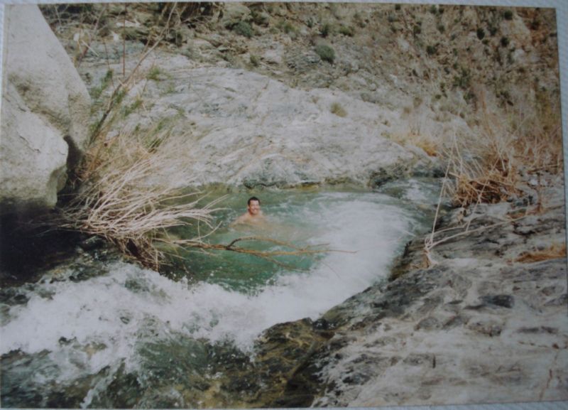
Tom and I have been going out to McCain Valley the last couple of months for some backpack and car camping trips just exploring around the immense boulder strewn In-Ko-Pah mountain range. Some of our explorations were in ABDSP and some crossed into BLM territories. The weather has been pretty hot this summer and the 4,000+' higher altitude of McCain Valley was tolerable for many weekends. Wildlife was scarce, Pepperwood Spring was dry and the only other people we saw on any of our hikes were OHV users driving around where they shouldn't have been.
I lugged along my Olympus 35mm camera with a roll of Fuji Velvia and struggled to take 29 pictures before I finally decided to roll it up and get it developed..wasting 7 precious frames of Velvia goodness. There really is something magical about Velvia film, it is amazing sharp, colors are warm and beautiful and holding the film in your hands and looking at it thru a loupe reminds me of when I was kid and had all the Disney slides for my View Master....pure joy....
All of the photos on this post are Fuji Velvia 50 35mm from my Olympus OM-1n. Processed at NCP in Carlsbad CA and scanned by me with an Epson V700 scanner. I did no touch up to them other than a small zap of USM.
Here is a really nice early morning view of Canebrake Wash from the Pepperwood trail. Red Top is just out of site on the right side. I have crossed over that pass on the left several times on trips to Potrero

One place I have been trying to find for several years was Thunder Canyon and Tom and I found it...barely. It is very difficult to find and we almost gave up but decided to look down "one more" crack in the boulders. Here is a view of the boulder pile where we found it, even standing right next to it you will miss it if you are not trying to find it on purpose

There is an old coral nearby but has no significant clues to it's location

We did find some nice pictographs and mortars nearby. Here are before and after pictures of DStretch in action with Film photographs. These were scanned on an Epson v700 and Vuescan Pro. I think they are very nice and in some ways better than the digital versions. Large format film I am sure would really make the quality of DStretch images better than any digital cameras


Pepperwood Trail is a regular corridor for undocumented travelers and they will leave behind all kinds clothing discards and in particular shoe covers that keep their tracks from being seen

Some people may not know about it but there will be a wind turbine farm soon built in McCain Valley and turbines will be along one of the ridges that separate McCain Valley and Thing Valley so Tom and I climbed up the ridge to have a look around and the views were amazing. It will be such a shame to put big turbines there.
Here is the ridge we climbed up, my camera jammed on the shot so it doubled up the exposure but you get the idea

Up on the ridge line where the turbines will be placed you can see all of the Carrizo Mtn range, Ocotillo, Canebrake, Fish Creek, just about anywhere east

Tom and I surmised this was some kind of wind data collection pole since it had several spinning things at the top and what looked like CDMA communications strapped on the pole

Tom looking out over Thing Valley and towards the Laguna Observatory

Misc Flora

And Tom near Lowenbrau Pinnacle

Total Balloons for these trips - 20+ stopped counting
---- |
10/8/2015
Topic:
98 Years in Prison for looting artifacts in Califo
dsefcikAdministrator
|
That looks like maybe 102 years tops...hopefully you won't get caught until you are 98 or so... |
10/9/2015
Topic:
98 Years in Prison for looting artifacts in Califo
dsefcikAdministrator
|
He actually knows where everything is also, he has it meticulously inventoried on his iPad. |
10/14/2015
Topic:
McCain Valley / In-Ko-Pah Mts Last 2 months
dsefcikAdministrator
|
Nice pics Tom....mine are still rolled up and waiting to be developed...
The views out here are just amazing, especially at night way up on the boulder piles like Sombrero and such. Looking forward to another trip out... |
10/20/2015
Topic:
The Year in Archaeology Oct 22nd 2015 at the ABDSP
dsefcikAdministrator
|
Colorado Desert Archeology Society Program
“The Year in Archaeology”
with
Robin Connors, Colorado Desert District Archaeologist
Thursday, October 22, 2015 – 2:00 pm – ABDSP Visitor Center
- Volunteers, staff, and the public are invited -
Anza Borrego Desert State Park is rich with cultural resources, an Archaeologist’s dream! And the dream came true for Robin Connors, who was hired a year ago as the District’s Archaeologist. Join us for a look back at her first year, a time filled with new challenges.
It began last winter when Robin took the lead in a major effort to restore a significant cultural site which had been looted for many years. Gathering together a team of staff and volunteers, she skillfully directed the work which resulted in the restoration of a treasured site.
So it’s been a very busy year in the life of an archaeologist whose task it is to protect over 700,000 acres of cultural resources, there is enough to last a lifetime. Come find out just what happens when you get to live your dream… |
10/22/2015
Topic:
The Year in Archaeology Oct 22nd 2015 at the ABDSP
dsefcikAdministrator
|
rockhopper wrote:
btw Was the fourm page chronology acting a little wonkey or was it just my c'puter
Cheers That was the result of some spammer posts, I don't think I can fix it, I am hoping Bob(surfponto) can look into it. |
10/22/2015
Topic:
BORREGO DAYS DESERT FESTIVAL - OCT 23-25th
dsefcikAdministrator
|
Sorta late notice and I will not be going but for those that may be interested
http://borregospringschamber.com/BorregoDays/index.html
I will be out with Gary, Tom & crew backpacking in Rockhouse canyon for the weekend. |
10/26/2015
Topic:
BORREGO DAYS DESERT FESTIVAL - OCT 23-25th
dsefcikAdministrator
|
Scott Turner wrote:
Will you update us on water conditions at Nicholas Canyon? I'm taking three days back there in December. No guarantee that El Nino will start delivering the goods until January, so I want to make sure I'm prepared. We did not go to Nicholias this trip, we were more near the trail up to Martinez Cyn and there was plenty of water there. I am sure you will have water at Nicholias, that is pretty much year round always. |
10/26/2015
Topic:
Carrizo Gorge
dsefcikAdministrator
|
The Tamarisk is gone from about Goat Canyon north to the road, they have been working for the last 2 years to clear it. They may be back out now continuing the removal efforts since summer is over. You can easily hike from the Carrizo Gorge road end to Goat Canyon in a couple of hours, the brush is all gone. After that though it can still be very ugly and full of ticks. I was out several times this year and you can find trip reports here or on my website http://www.carrizogorge.com
-- |
10/28/2015
Topic:
The Year in Archaeology Oct 22nd 2015 at the ABDSP
dsefcikAdministrator
|
Looks like you fixed it Bob??
surfponto wrote:
I see why it is doing it.I need to fix.
dsefcik wrote:
rockhopper wrote:
btw Was the fourm page chronology acting a little wonkey or was it just my c'puter
Cheers That was the result of some spammer posts, I don't think I can fix it, I am hoping Bob(surfponto) can look into it.
edited by surfponto on 10/22/2015 |
10/28/2015
Topic:
THE MAJESTIC DESERT BIGHORN SHEEP OF ANZA-BORREGO
dsefcikAdministrator
|
http://www.theabf.org/majestic-desert-bighorn-sheep-anza-borrego
Happy fall everyone!
For the first class in ABF’s new program series, Anza-Borrego: In Focus, Mark Jorgensen will be giving a lecture on our Park’s “Magnificent Bighorn Sheep” this Friday, October 30 at 7:30 pm at the Steele/Burnand Anza-Borrego Desert Research Center. The fee is $5 at the door. We hope you’ll join us for the lecture on Friday to learn from one of the Park’s greatest sheep experts! (Unfortunately, the field class on Saturday is already full.) Details below and flyer attached.
The Majestic Desert Bighorn Sheep of Anza-Borrego
Underwritten in memory of Fran Medema
October 30-31, 2015
Instructor: Mark C. Jorgensen, desert bighorn sheep researcher and retired Park Superintendent
Mark will provide a lively presentation about Anza-Borrego's iconic animal and its wilderness habitat. The program will highlight the magnificent bighorn's adaptations to survive in some of the harshest habitats in North America and the efforts underway to restore and maintain populations of desert bighorn not only in Anza-Borrego, but throughout the Southwest and northern Mexico. Jorgensen's talk will be beautifully illustrated with photographs by Jeff Young featuring rare behavior, massive rams in ritualized combat, and ewes nurturing their newborn lambs.
Steele/Burnand Anza-Borrego Desert Research Center
401 Tilting T Drive
Borrego Springs |
10/30/2015
Topic:
Diablo Dropoff graded
dsefcikAdministrator
|
sddarkman619 wrote:
The squeeze is open.
Body modificationion progress... hummm..maybe I have my roads mixed up..?? |
10/30/2015
Topic:
Diablo Dropoff graded
dsefcikAdministrator
|
So I guess I had my roads mixed up...didn't realize the Pinyon Mtn forked off to the squeeze so yes, it looks like it is open. Thanks sdarkman619 for correcting me and letting us know, I may try and squeeze my truck thru it soon.... |
10/30/2015
Topic:
Diablo Dropoff graded
dsefcikAdministrator
|
sddarkman619 wrote:
I'm heading out to diablo dropoff to get to split mtn on sunday. someone put a bunch of toys animals in some of the wind holes there and we(my two little girls and I) are going to go out and clean them out of there. Girls are stoked to get the toys but the desert shouldn't be littered like that, even if it was a cute idea.
Welcome to go along if you'd like. try to get to badland overlook to meet a friend by 9am. I saw them in your photo, good idea...I may try and go out to meet you, I do not know those roads back in there very well, would be great to drive them with somebody else....will contact you offline to confirm...thanks. |
11/1/2015
Topic:
McCain Valley / In-Ko-Pah Mts Last 2 months
dsefcikAdministrator
|
Got a few more photos developed from the last McCain trip, hope you enjoy...
These old state park signs were originally mounted to redwood posts (sombrero peak background)

This is the headwaters of Bow Willow Creek where it meets the Thing Valley ridge line (home of the new Tule wind turbines).
I thought it was an interesting picture, the shadows were just right to bring out the long draw of the dried up creek bottom.
Note the lone Cottonwood in the middle of the creek (yellow leaves)

These next 2 images I think Tom may have already posted a version of
Here is the Cowboy Crapper...I think I prefer the bushes....

In the midst of arguably the driest season known to us there is still some water in the middle of the high desert

Great views from the In-Ko-Pah mountains, Carrizo Gorge and the Ocotillo Wind Farm below

Panorama of the whole desert floor from Sombrero Peak to Ocotillo

-- |
11/1/2015
Topic:
McCain Valley / In-Ko-Pah Mts Last 2 months
dsefcikAdministrator
|
Jim (ziphius) wrote:
Curious, is that spring / trough marked on the topo? It is near a marked spring but not right on it. |
11/1/2015
Topic:
McCain Valley / In-Ko-Pah Mts Last 2 months
dsefcikAdministrator
|
tommy750 wrote:
I think the white shirt makes me look fat... I think the fat makes you like white..... |
11/3/2015
Topic:
CalTopo Route Planning: What's Next?
dsefcikAdministrator
|
Matt has been great to me over the last few years, he responds quickly, has made changes based on some suggestions I have had and he really has made an awesome online mapping system. I knew this was coming, he has been suggesting it for some time. I have made donations to him in the past and will most likely buy into his map system, it is the most useful mapping tool for me I have seen or used.
Thanks for posting thins JIm... |
11/3/2015
Topic:
CalTopo Route Planning: What's Next?
dsefcikAdministrator
|
I just paid my subscription...I hope he finally gets some payment back out of it....long overdue. |
11/4/2015
Topic:
dos cabezas
dsefcikAdministrator
|
It is in ABDSP
The main road is on maps and is now flanked with wind turbines, can't miss it as it goes right thru the heart of the installation. At some point the road leaves the wind turbines and gets a little rougher but 2wd truck or such should be able to make it. I have seen all sorts of passenger cars out there so with careful driving you are probably fine. Any 4wd type truck/jeep etc will go anywhere near there no problem. You will need to choose your tracks crossing wisely.
Fires need to be completely self contained in a metal container not just have a ring, basically when you leave nobody should be able to tell you were there.
Good luck, have fun and report back...and welcome to the ABDSP forums! |
11/4/2015
Topic:
Un Cabeza Del Lobo
dsefcikAdministrator
|
Have read them all, still looking for the emerald mine....
Just go get out there and explore, you will soon find it is not as easy as many of the stories suggest, RHC is huge. |
11/5/2015
Topic:
dos cabezas
dsefcikAdministrator
|
wintyfresh wrote:
If you're heading to the siding station just take Mortero Wash (just north of the Border Patrol station), should be doable in a 2wd. There is a section about 1/2 mile or so from the pavement that can be very sandy, the Dos Cabezas rd is hard dirt so just keep that in mind also. |
11/6/2015
Topic:
Un Cabeza Del Lobo
dsefcikAdministrator
|
mattherrington wrote:
Seems like I met you (or your twin) oncoming traffic near the top of Whale Peak a winter or two ago. Two guys having come from either the W or S approach (not the Pinion Mtn road easy way as we had come) near the top and your twin was ruthlessly dispatching cairn after useless cairn (I mean, all you've got to do is get to the top) back to whence they had came. Sound possible?
Probably not me, doesn't sound like my style.... |
11/6/2015
Topic:
Diablo Dropoff graded
dsefcikAdministrator
|
mattherrington wrote:
Sounds like yes if it's graded everywhere up (SW) of there. I know a couple years ago they graded just about everywhere I went...except Rockhouse Canyon....not sure about since then though. |
11/6/2015
Topic:
Diablo Dropoff graded
dsefcikAdministrator
|
wintyfresh wrote:
Yep, Broken Shaft Gulch was graded too. Where is Broken Shaft Gulch? Sorry, I am not a big off roader so I am not familiar with a lot of the off road areas...well technically there is no such thing "off road areas" since all vehicle travel off established roads is prohibited in ABDSP but you know what I mean... |
11/7/2015
Topic:
Diablo Dropoff graded
dsefcikAdministrator
|
sddarkman619 wrote:
and if it was graded it was with a narrow blade. Almost 2 years ago this month it was graded all the way down to the main fish creek road, a prius could have probably made it. I did not get a picture of the section between the main fish creek rd and the uphill but here is what it looked like from the top
 |
11/8/2015
Topic:
Diablo Dropoff graded
dsefcikAdministrator
|
Nice...I guess you could kinda call that a "toy drive".... |
11/8/2015
Topic:
Diablo Dropoff graded
dsefcikAdministrator
|
sddarkman619 wrote:
When I saw it in person I was sort of miffed that someone would do that. This was out on the road to Panamint near Trona...I about died laughing when I saw it


 |
11/9/2015
Topic:
Photo Contest winner :)
dsefcikAdministrator
|
yeah, OK..you're famous.... |
11/9/2015
Topic:
Diablo Dropoff graded
dsefcikAdministrator
|
sddarkman619 wrote:
the rest was donated(that were salvageable) to children without toys. .... |
11/12/2015
Topic:
Santa Rosas / Rockhouse Canyon 4 Day Backpack
dsefcikAdministrator
|
Here are a few pics from our recent backpack trip into Rockhouse Canyon where we spent 3 days base camped near the trail that leads up and over to Martinez Canyon and explored the various fingers that lead to and around the Necklace. It felt good to just relax for a few days and explore with a light day pack instead of lugging around a big heavy pack everyday. We were able to squeeze enough good water out of Stifferino to keep us happy for the whole trip. The repairs we made several years ago to the spring seem to be holding up with minor upkeep and it is also providing a bit better of a watering hole for the wildlife.
With the exception of the close up insects all of the photos are Fuji Velvia 50 film taken with my medium format Fuji GSW645 camera
Hope you enjoy


Total Balloon count this trip - 10+ I have been pretty lame lately not taking pictures and not keeping good count, maybe that can be my new years resolution..haha...
-- |
11/12/2015
Topic:
Santa Rosas expedition partner wanted, Dec. 20-24
dsefcikAdministrator
|
I have tentative plans already for the Xmas break but have not nailed down any specific dates yet. If I have that week available I wouldn't mind joining you. |
11/12/2015
Topic:
Lots of Renewable Energy Fun in the Deserts
dsefcikAdministrator
|
From the BLM News Bytes
DESERT RENEWABLE ENERGY CONSERVATION PLAN |  | Desert Renewable Energy Conservation PlanThe Department of the Interior and the State of California announced the final environmental review of the Desert Renewable Energy Conservation Plan. The DRECP is an innovative landscape-scale plan that provides protection and conservation for wildlife, recreation and cultural resources in the California desert while encouraging streamlined renewable energy development in the right places.(BLM Facebook)
Related: Interior Department, State of California Announce Innovative Strategy for Renewable Energy and Conservation on Public Lands in California Desert (BLM News Release)
Related: DRECP (Drecp.org)
|  | Environmental Plan Balances Conservation and Renewable Energy in the California DesertWilderness.org, 11/10/2015
The Bureau of Land Management’s (BLM) plan for the California desert, released today, could have lasting benefits for both conservation and renewable energy. The Desert Renewable Energy Conservation Plan (DRECP) was initiated to find appropriate places for development—and just as important—those that are not. (Read full story)
| Plan Designates Desert Land for Renewable Energy Development
Sacramento Bee, 11/10/2015
A sweeping plan released Tuesday to regulate development of renewable energy in Southern California deserts designates nearly 400,000 acres for potential solar, wind and geothermal plants and millions more acres for conservation and recreation. (Read full story)
|  | After 7 years, Desert Renewable Energy Plan FinalizedThe Desert Sun, 11/10/2015
State and federal officials released a sweeping plan for the future of California’s deserts Tuesday, designating areas for renewable energy development, conservation and recreation across 10 million acres overseen by the Bureau of Land Management. (Read full story)
| Final Draft of Desert Renewable Energy Conservation Plan Released
The Sun, 11/10/2015
Federal and state officials Tuesday released a final draft of the federal portion of the Desert Renewable Energy Conservation Plan. Officials call the plan, which covers about 22.5 million acres of federal and non-federal California desert land, an unprecedented cooperative effort to manage where California’s renewable energy conservation projects go to preserve plant and animal habitat as well as recreation areas. (Read full story)
|
|
11/13/2015
Topic:
Santa Rosas expedition partner wanted, Dec. 20-24
dsefcikAdministrator
|
rockhopper wrote:
I love your old photos, makes me want to go put some film in my camera now...! oh wait....I already do...ha...thanks for posting those..we will be heading heading out to Martinez next week. |
11/13/2015
Topic:
San Ysidro - East approach
dsefcikAdministrator
|
Another "I haven't done that route" but it looks easy on google earth....
Good chance you'll see some bighorn
 |
11/15/2015
Topic:
Santa Rosas / Rockhouse Canyon 4 Day Backpack
dsefcikAdministrator
|
rockhopper wrote:
Nice photos as always. I'm not worthy! Nice to see the spring flowing. Good work. And nice arrow point find. Good eye to spot that one. What elevation did you find it? How far east from the Santa Rosa ridge line do you go?
Cheers.
btw Enjoy Martinez canyon We based camped in RHC at the bottom of the Santa Rosa's and climbed the fingers going up to the top of the rifgeline so we could see Cochella, Salton sea, etc. Gary found the point somewhere not to high up, he seems to find them regularly. |
11/15/2015
Topic:
Santa Rosas / Rockhouse Canyon 4 Day Backpack
dsefcikAdministrator
|
nice pics tom...!!
we split up on the ridge so i didn't see the ram and i don't think you saw all the mortars with holes thru them.
i remember that snooze, not even 2 hours into the hike from the cars...phewww! |
11/17/2015
Topic:
Combs Peak Hike
dsefcikAdministrator
|
Nice trip and good to see you back again BW....I had looked at your blog not too long ago just to make sure you were still on track with your new years challenge..how is that looking? Last entry I see is in July...! |
11/29/2015
Topic:
Martinez and Agua Alta Canyons Backpack
dsefcikAdministrator
|
Nice Tom...yeah, I got home last night and am just getting caught up with things...here are a couple of shots inside the cabin....I'll post up some more after my negatives finishing drying.
Here is the main living room

Here is the kitchen area

-- |
11/30/2015
Topic:
San Ysidro Mountain - East Approach
dsefcikAdministrator
|
Nice to see some of the lesser explored areas of the park.... |
12/1/2015
Topic:
Cactus spring trail to Martinez Canyon Rock House
dsefcikAdministrator
|
Look familiar?
Ours was the next one....

edited by dsefcik on 12/1/2015 |
12/2/2015
Topic:
Martinez and Agua Alta Canyons Backpack
dsefcikAdministrator
|
Got a few pics finally ready...all the B/W are from my 1937 Zeiss Ikon Nettar 515/2 folding "pocket" camera, HP4 film, Rodinal 1:100 @90 minutes stand development.
Tom and Gary at the Narrows

Tahquitz Canyon Sunset

Smoke Tree

Jack Miller's Cabin

Gary & Joel amongst the Tamarisk Forest that is now in Martinez Canyon

Read All About It

Beautiful and damn cold sunrise up on the Agua Alta bench, clouds, rain and eventually snow moved in on the Santa Rosa range


Old, abandoned guzzler that overlooks the Alta Agua Canyon

Dried up bee hive in the water box


Total Mylar Balloons this trip - about 2 bags full between us

-- |
12/2/2015
Topic:
Martinez and Agua Alta Canyons Backpack
dsefcikAdministrator
|
rockhopper wrote:
Daren, how did that water taste? Hope you are ok. Nothing like burping up algae iodine water all day....yummm, made my coffee and oatmeal have some added trail flavor. By the last day it was tasting good, kinda missed it.... |
12/2/2015
Topic:
San Ysidro Mountain - East Approach
dsefcikAdministrator
|
Viper wrote:
Unfortunately, no good pics into the South Fork. This one looks toward the South Fork (apologies if my picture-posting skills are not yet up to snuff):
Summit register:
When in doubt, pinky out....pics look..thanks for struggling thru that effort..!!
--
edited by dsefcik on 12/2/2015 |
12/8/2015
Topic:
Mojave National Preserve and other areas
dsefcikAdministrator
|
yep, good stuff..glad you didn't wait for Tom and I...we still keep talking about going back but don't seem to do it.
11.9?? I think I have the opposite photo of 150 in DV.
|
12/12/2015
Topic:
Drone use in the Park
dsefcikAdministrator
|
Interesting find Jim.....yes, this is a topic that I am sure will stay current for some time.
My guess is that people will continue to fly them at will until there are genuine financial repercussions. |
12/13/2015
Topic:
Tabletop/Trestle/Mortero Palms/Dos Cabezas Spring
dsefcikAdministrator
|
ImpatientHiker wrote:
It was when I came across a large Bighorn carcass that my day changed. It didn't take long to realize that it was a very fresh kill with clumps of brush clawed up over it and slobber still wet on the bloody, pierced neck
Emailed you about this...thanks. |
12/13/2015
Topic:
Hiker rescued in Rock house canyon 12-13-15
dsefcikAdministrator
|
Hiker 
thanks rockhopper... |
12/15/2015
Topic:
Sheep Canyon Pot Farm
dsefcikAdministrator
|
The pot farms are gone, you will have to go hiking and find a new one.... |
12/15/2015
Topic:
Tabletop/Trestle/Mortero Palms/Dos Cabezas Spring
dsefcikAdministrator
|
Another great run IH and a great Ram find (well not so great for the ram). Any photos of the trip you can post would be cool. |
1/2/2016
Topic:
Last Days In The Desert movie
dsefcikAdministrator
|
When is this movie supposed to be out? I looked at all of the social media pages and I just don't get it... |
1/20/2016
Topic:
Moderation
dsefcikAdministrator
|
Thank you Florian....it is a known issue with the software and Bob and I are discussing options. We will contact you if we need any additional help. |
1/24/2016
Topic:
Sheep Canyon, South Fork Sheep Canyon, Cougar Cany
dsefcikAdministrator
|
Buford wrote:
I know it is a little late, but there was plenty of water back there last weekend (January 16-17) after all the rain. Thanks Buford, never too late to know where there is water available.. |
1/25/2016
Topic:
Anza Borrego Site Redo
dsefcikAdministrator
|
Looks good so far... |
1/25/2016
Topic:
Anza Borrego Site Redo
dsefcikAdministrator
|
1. "back to the website" link goes to old website
2. Sort order of messages now seems to be "newest first", how to change? |
1/25/2016
Topic:
Anza Borrego Site Redo
dsefcikAdministrator
|
Lets let others chime in, oldest to newest is what I would expect...there is no option for the user to decide as a preference?
Bob Baran wrote:
dsefcik wrote:
1. "back to the website" link goes to old website
2. Sort order of messages now seems to be "newest first", how to change?
Do you want the forum threads sorted oldest to newest?
I have seen it done both ways.
I am fine either way. |
1/25/2016
Topic:
Anza Borrego Site Redo
dsefcikAdministrator
|
For anyone who has layout problems, please clear your cache and do a force reload on the pages to see if that clears it up. |
1/25/2016
Topic:
Anza Borrego Site Redo
dsefcikAdministrator
|
BTW, FireFox works fine on my computer (Linux Mint, FF version 43.0) |
1/25/2016
Topic:
San Diego Backcountry & Anza-Borrego Desert map
dsefcikAdministrator
|
I am not sure I get this, it is a PDF map for your phone? |
1/27/2016
Topic:
Anza Borrego Site Redo
dsefcikAdministrator
|
That scrolls because of large images in the post, not layout problems, the forum software does not dynamically resize images for you so if you post large images it will cause the browser to scroll.
sddarkman619 wrote:
dsefcik wrote:
BTW, FireFox works fine on my computer (Linux Mint, FF version 43.0)
Daren check this:
http://www.anzaborrego.net/anzaborrego/forum/viewpostsbyuser.aspx?UserID=29&Page=18
do you have to scroll right ? seems like the container isn't formatted correctly. Did the cache clean and refresh and nothing, I think it's a theme/css issue. might be browser specific, but the forum works in most areas in others it's not. |
2/8/2016
Topic:
Tarantulas, Cahuilla Indians, & Johnny Cash
dsefcikAdministrator
|
Nice truck....
surfponto wrote:
I like Johnny Cash

ziphius wrote:
all in the same article: http://www.cbsnews.com/news/tarantula-species-named-for-johnny-cash/ |
2/9/2016
Topic:
Villager Peak trailhead vandalism
dsefcikAdministrator
|
That is my sheep counting partner for Rattlesnake Spring, he went to stash water this weekend and that was his reward...thanks to SOB who did that... |
2/9/2016
Topic:
Villager Peak trailhead vandalism
dsefcikAdministrator
|
Here is the other side of the car, they stole everything inside and ruined the chassis with the boulders
 |
2/9/2016
Topic:
Villager Peak trailhead vandalism
dsefcikAdministrator
|
Florian wrote:
Was your friend gone overnight or just a day hike?
Overnight |
2/9/2016
Topic:
Villager Peak trailhead vandalism
dsefcikAdministrator
|
The call box there didn't work either...just to polish off the problem. But the Park Rangers and Highway Patrol had already seen it and were helping out.
Buford wrote:
That sucks.
Hope this does not become a thing out here. I haven't heard of this too much in Borrego before.
That is one of my fears, coming back to find a vehicle gone or destroyed and no cell reception. |
2/14/2016
Topic:
Jamul Kiln Ruins
dsefcikAdministrator
|
railexplorer wrote:
So I was able to take a trip out to the Jamul Cement Kilns (Its all a matter of who you know). Remembering this thread I asked who was in charge of the reserve. I had to laugh because I couldn't get a straight answer. hummm...I didn't seem to have any problems finding out who was in charge and scheduling a visit...they just don't want people out there. |
2/24/2016
Topic:
Palm Mesa High Point and nearby benchmarks
dsefcikAdministrator
|
Looks like a nice area, would have thought there would be some water by now though.....I like the deer...nice TR, thanks for posting and welcome to the forums... |
2/26/2016
Topic:
Photo being used on new panels
dsefcikAdministrator
|
Will keep an eye out for the new signs.....the new signs by the taco shop have many of Ranger Bier's photos. |
3/6/2016
Topic:
Anza Borrego Wildflower Update
dsefcikAdministrator
|
Maybe after this weeks rains the blooms will begin to start popping up. |
3/16/2016
Topic:
Swainson's Hawk migration
dsefcikAdministrator
|
Nice Jim..thanks... |
3/17/2016
Topic:
Jamul Kiln Ruins
dsefcikAdministrator
|
sddarkman619 wrote:
For anyone not wanting to get some run around or whatever there's a guided tour hike for this place april 9th:
http://earthdiscovery.org/events/san-diego-natural-history-museum-canyoneers-hike-at-rancho-jamul-ecological-reserve/
Thanks for the update... |
3/29/2016
Topic:
Vandalism on S22
dsefcikAdministrator
|
tomasphoto wrote:
Does anyone know of any more vandalism on cars parked overnight on S22? I want to backpack up Smoke Tree Cyn and down Palo Verde and don't want to leave my truck near the pavement. I'm thinking of driving into Coachwhip and leaving my vehicle hidden in there. Any info would be appreciated! I take it the car that had its wheels taken was parked just off the pavement? Sorry about the short request for a reply(I am going tomorrow morning).
Thanks in advance,
Tomás I don't think it is all that common, years past they had problems along the S22 but I think the recent one was just bad luck. You could just park over in the Arroyo Salado campground and walk a little further, that is what I have done. |
3/31/2016
Topic:
Forum Thread Order
dsefcikAdministrator
|
oldest first, that is the time honored order of forum threads...first to last. |
4/11/2016
Topic:
Hiking to the top of Viejas Mountain
dsefcikAdministrator
|
Bob, you already have your permits, you got space in the lottery? We used to do the mountaineers route when it was permit free but now you need one for any ascent (apparently). We also did Langley one year, I almost preferred it, much less of a crowd. If you have time, I recommend spending a day or two up at the portal or doing a couple of day hikes up to lone pine lake to get used to the altitude. Leave early, 2-3am. |
4/12/2016
Topic:
What Is This??
dsefcikAdministrator
|
Going with miners candle holder
http://www.miningartifacts.org/minerscandleholders.html |
4/16/2016
Topic:
Hiking to the top of Viejas Mountain
dsefcikAdministrator
|
Love rockhopper's old photos..thanks for posting..! |
4/16/2016
Topic:
Hiking to the top of Viejas Mountain
dsefcikAdministrator
|
Make sure to bring your wrestling masks....

and make time to visit alabama hills

and always remember who's #1

it will be hot
--
edited by dsefcik on 4/16/2016 |
4/17/2016
Topic:
Jacumba and Table Mountain Exploration
dsefcikAdministrator
|
anutami wrote:
Really? I find that hard to believe. Any more information on how they are formed? They seem to always be around village sites and from my experience I would say it is obvious they are man made. General consensus from folks who study them say they are geological formations but then there are folks who listen to Coast to Coast every night and always stop to visit Coyote Jeff next to the Desert Tower...

 |
4/30/2016
Topic:
Jacumba and Table Mountain Exploration
dsefcikAdministrator
|
ziphius wrote:
listening to archived Art Bell episodes from my backyard.... a good use of a Saturday night. I miss Art Bell, the new guy just isn't the same...kinda like Johnny Carson, nobody since has been the same.... |
5/1/2016
Topic:
Santa Rosa Mnts / Martinez Canyon 12 Day Backpack
dsefcikAdministrator
|
I have been battling some personal issues for the last several months and have not been as active as I normally would be, I hope to participate more in the coming months with all of your adventures, I have enjoyed reading many of the posts here lately even though I may not be actively participating in many of the discussions. Here is a trip report I have been meaning to post for months and am now finally getting to it.
====================
Long overdue are some trip reports for Dec 2015 and the first quarter of 2016. Over the Christmas/Winter/Holiday (take your pick) Break I managed to get almost 12 days of backpacking in the Santa Rosa Mountains and Martinez Canyon area. Most of these photos are from a small Olympus XA film camera I picked up just for backpacking trips. It is a small lightweight 35mm film camera that takes very sharp pictures. Fuji Velvia 50 slide film provided lots of color and an old school look that I love so much in photos.
(Click on any of the photos to see a larger size version)
Sort of an Ansel Adams moment atop a razor sharp and crumbly limestone ridge

A panorama from the same ridge looking towards Cochella (click to see full size image)

This is a small area of the now dried up Lake Cahuilla shoreline. The years gone by have left an easily seen water line on the rocks

Personally I prefer to just squat over a hole in the ground but if you gotta sit while taking care of business then this would be your best friend

Moon rise from an unnamed canyon we camped in

Lots of Bighorn Tracks and body parts


Those old time cowboys really knew how to party, Gallo Wine and Hostetter's Stomach Bitters

There are also a handful of photos from my new Garmin Montana 600 GPS, it surprised me with how good of photos it can take and it is able to evaluate some tough low light exposures pretty well (sunrise/sunset).
Early morning sunrise looking at Toro Peak, yes, those are patches of snow on the ground, it was cold at night up on the mountain range!

Randy is hauling a hefty pack up several thousand feet of climbing in one day, I am not sure how he does it, especially with the light snow all over the place making it very slippery

The snow we had for a couple of days made animal tracking lots of fun and we did not need to carry much water since we could drink/eat the snow

Sunrise over the Salton Sea. I have to say that waking up in the morning and looking out over the Salton Sea from anywhere on the Santa Rosa mountain range is without a doubt one of my favorite parts of any trip up there, it is just magical

There are probably dozens of airplane wrecks in the Santa Rosa mountains, we found one


Gary & Randy enjoying some morning Starbucks looking out over Cochella Valley, damn it was cold..!!

Up near Rabbit Peak we could see down into Borrego Springs and Clark Lake

I hope you enjoy these photos of Martinez Canyon area and the Santa Rosa Mountain range |
5/2/2016
Topic:
Hiking to the top of Guatay Mountain
dsefcikAdministrator
|
ziphius wrote:
If you're looking for Whitney training opportunities, the El Cajon Mtn. hike is a good one! - Jim Agreed, put that on your training list. |
5/2/2016
Topic:
Santa Rosa Mnts / Martinez Canyon 12 Day Backpack
dsefcikAdministrator
|
anutami wrote:
my kids are growing up so fast and life just keeps getting in the way I can't get mine to go out anymore..enjoy your time with them while you can. |
5/2/2016
Topic:
Santa Rosa Mnts / Martinez Canyon 12 Day Backpack
dsefcikAdministrator
|
rockhopper wrote:
Nice expedition trip and great photography! I really like the sunrise over the Salton sea pic. Did you know of the plane crash site or just stumble upon it? Looks like it was on the ridge. Missed it by that much...Nice there was a little snow for water but cold at nite. Did you guys measure the low temps in the am? Nice arrowhead too! We had heard tales of the plane but that was not our MO for the trip, only a side trip for something to find. Night temps were low 20's with a couple of 17'ers. Most mornings the tents were frozen over crunchy, any condensation was thin ice sheets. The killer part in winter is the nights are 14 hours long and it is so damn cold you just want to stay in your down bags. Gary was the only one who did not use a tent that trip AND he forgot his sleeping pad so he slept on a sheet of blue plastic on the hard dirt every night and the first night in the rain under a rock shelter full of rat crap. |
5/4/2016
Topic:
Yoni
dsefcikAdministrator
|
http://www.darensefcik.com/Photography/Rock-Art/Yoni
I forgot I had put these online several years ago, many of them will be recognizable, some are in areas way off any beaten path...let the yoni wars begin.... |
5/8/2016
Topic:
Happy Mothers Day from ABDSP
dsefcikAdministrator
|
Found this today arriving back to the car in Rockhouse Canyon (well, descending a steep wall in the canyon)
|