5/15/2017
Topic:
What footwear do you use for desert hiking?
dsefcikAdministrator
|
I have been using Asolo boots for years, I like them and usually get them cheap on Sierra Trading Post. I prefer heavy boots though with Vibram type soles to keep cactus out, I have had cactus go right thru the sole of light weight trail hiking type shoes/boots but much of my travel in the desert is cross country and bush whacking. If I do wear some low cut shoes and shorts Dirty Girl Gaiters are wrapped around my ankles.
edited by dsefcik on 5/15/2017 |
5/20/2017
Topic:
Sleeping with Snakes?
dsefcikAdministrator
|
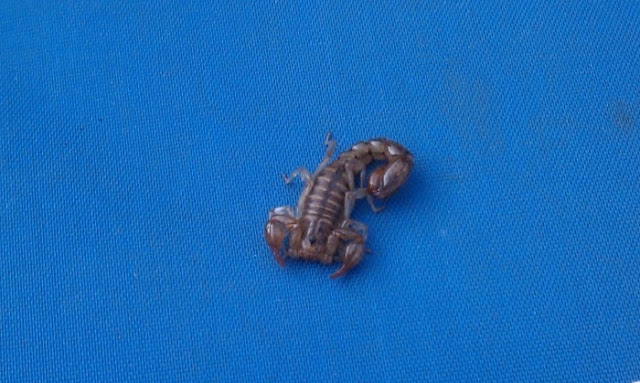
Been sleeping on the ground for years, never had a problem with snakes. Mosquitoes can be a problem more than anything else but you can use a flip out net or get a bivy with a built in net. I use a military bivy that the top does not seal up closed, only just flips over. I use and like it mostly for wind protection and to keep cactus off my expensive sleeping bag. I have had several occasions though were I will wake up and find a scorpion or tarantula between my bag and sleep pad.

 |
5/21/2017
Topic:
Burrowing Owls
dsefcikAdministrator
|
Very nice, I have never actually seen one out in the field. I need to start taking my digital camera and zoom lens out again, you have given me a little motivation. |
5/21/2017
Topic:
Sleeping with Snakes?
dsefcikAdministrator
|
Another option for fair weather is just an open air bug tent, I have the old version of one of these Bug Hut shelters and used it a few times in the past.
There is also a full length Bug Bivy, I have an older version that I don't use anymmore. |
5/21/2017
Topic:
Sleeping with Snakes?
dsefcikAdministrator
|
I use the military Gore-Tex bivy usually but recently bought an OR Helium Bivy for longer trips since it is much lighter weight and packs smaller and it has worked well and keeps the bugs off. |
5/21/2017
Topic:
Burrowing Owls
dsefcikAdministrator
|
This is my usual DSLR carry system...right on the sternum strap.

-- |
5/23/2017
Topic:
Sleeping with Snakes?
dsefcikAdministrator
|
GoLite poncho tarp, versatile, lightweight, adaptable, still gets put in my pack for many trips


Tarp tent, rarely used, nice idea but not really practical

BugHut, a good idea, covers sleeping bag and keeps critters out mostly...has a place I suppose for some people, not used much anymore, will probably put on ebay

Bughut pro, too much orange filter on the camera, Turtle mtns

BugHut Pro WITH Tarp Tent in the freezing rain, yeah I was cold, yeah I didn't use this combo again

Ultimately I still stand (well really lay down) behind my military goretex bivy, it has proven itself over and over again in the rain, the wind and the cactus. It weighs as much as a light weight tent but is so simple to pack, setup & breakdown I can do it drunk, hung over and in the dark....curl up and sleep worry free...it is my sleep system for years so far.. |
5/25/2017
Topic:
Hapaha or Hahapa Flat?
dsefcikAdministrator
|
I have always known it as Hapaha...old maps show "carriso" gorge and "borego" spring/valley...where are you seeing it as Hahapa? |
5/25/2017
Topic:
Hapaha or Hahapa Flat?
dsefcikAdministrator
|
I think the map in the book is just a mistake, everywhere else in the book it is referenced as Hapaha. People looking at the map probably just propagate the mistaken name. |
5/27/2017
Topic:
Sleeping with Snakes?
dsefcikAdministrator
|
Amazon, Ebay or GI Joes in El Cajon.... |
5/30/2017
Topic:
Desert Sentry
dsefcikAdministrator
|
Haven't seen it, will have to look for it next time....thanks for mentioning it. |
5/31/2017
Topic:
Desert Sentry
dsefcikAdministrator
|
Britain, when was the last time you can confirm it was still there? |
6/2/2017
Topic:
Palm Grove Jacumba wilderness
dsefcikAdministrator
|
There are quite a few pockets of palms in the Myer/Boulder Creek area. While I have not found anything to confirm, a ranger once told me that palms can look burnt like that after a long drought or absence of water. |
6/12/2017
Topic:
Big Boy between hwy 8
dsefcikAdministrator
|
sheep are common in that area, there is water at the spring (trough) and vehicle collisions do occur....nice photo |
6/19/2017
Topic:
2017 Sheep Count info
dsefcikAdministrator
|
Good to see you counting this year ziphius, I will be at Rattlesnake as usual. |
6/22/2017
Topic:
2017 Sheep Count info
dsefcikAdministrator
|
All of the sites are in the north end of the park, they do not count in the south end...not that they don't care about the "south" sheep, it is just a matter of staying consistent and I believe the DFG/DFW have their own method of tracking wildlife. I encourage anyone to volunteer that can tolerate 3 long days of sitting still scanning the landscape for BHS in 100+ temps, it can be a great experience or possibly the most boring and miserable thing you have ever done. Many people drop out after the orientation (REQUIRED for first time counters) and count site assignments shift around accordingly.
Hey, happy sheep counting to all the volunteers and thank you for your efforts..!! |
6/23/2017
Topic:
Tunes about Anza Borrego
dsefcikAdministrator
|
I listened to the audio snippet...interesting...thanks for posting and sharing. |
6/25/2017
Topic:
2017 Sheep Count info
dsefcikAdministrator
|
Britain wrote:
So who trucks in the water to you?  Do you camp at the site or packout everyday? Anywhere to read up on this? Do you camp at the site or packout everyday? Anywhere to read up on this?
Depends on the count site, there are all levels of count site opportunities, some are easy walk in everyday from your hotel sites and others are backpack only. Most sites require you to bring your own water each day, some may have water available to filter. Our site at Rattlesnake Spring we carry water up and bury it each spring and then pack out the empty containers. The count is for the most part completely self supported, the park really only provides you with a location, advice and paperwork to fill out, everything else is up to you, that is one reason why so many people drop out after the orientation, they think the park is gonna give them everything they need and take care of them but that is not how it works. |
6/25/2017
Topic:
2017 Sheep Count info
dsefcikAdministrator
|
I think Buford summed it up pretty good.... |
6/25/2017
Topic:
2017 Sheep Count info
dsefcikAdministrator
|
Britain wrote:
Thanks good write up. I'll need to get new glasses! Do envy that 600mm lens.
I don't take that anymore, too heavy...I got a trail camera last year to do all the work for me
http://www.sefcik.com/2016/07/bighorn-sheep-census-count-2016-abdsp.html |
6/25/2017
Topic:
2017 Sheep Count info
dsefcikAdministrator
|
Britain wrote:
I Looked over the application for this. I certainly would check the backpacking. Question. Is there a list of spotting sites this is done from? Reason is I would like to , when its cooler pack in to the worst ones and see whats required.
You csn see a list of the results and count sites here http://theabf.org/45th-annual-anza-borrego-sheep-count-results
Many of the sites have regulars (like Rattlesnake Spring) so it is not guaranteed you will get a site you request...you can certainly request a specific site but you may be assigned elsewhere if needed. |
6/25/2017
Topic:
2017 Sheep Count info
dsefcikAdministrator
|
Britain wrote:
Can you recommend a mad that shows these locations? My topo doesn't and I'm not familiar with this side of the park.
https://caltopo.com/ |
6/25/2017
Topic:
2017 Sheep Count info
dsefcikAdministrator
|
Britain wrote:
Trail camera, those are great shots and video! Camera??
https://www.amazon.com/gp/product/B01EK61B4I |
7/3/2017
Topic:
2017 Sheep Count info
dsefcikAdministrator
|
@Buford Thanks for the report and glad you had a good count
@ziphius Sorry you had no sheep, I saw that in the final results. At least you got to experience the count. Not every site will see sheep every year, it can vary dramtically year to year...glad you have decided to return next year.
Our Rattlesanke site was quite different this year. One of our veteran counters had some issues with the heat about 2 miles in so we turned around and hiked back out with him to get him to his vehicle and safety. There is no room for taking chances out there in the heat and so far away, phones do not work and any help is as far away as the hike out and drive into town and then back again. With 4 extra miles added to our hike my remaining partner and I got to the count site around 11:30pm, just in time for some star gazing and tequila from our hidden stash. Lots of shooting stars that night, beautiful.....
In the morning though we noticed a total absence of sign from sheep, no tracks, scat or urine stains, something very obvious year after year...sheep had not been coming here recently. We found the spring dry. We discussed options and decided to hike out before the sunrise and the heat, otherwise we would have had to wait until dusk to hike out in the cover of shade.
We did see 1 ram so our total count was 1, a historic low I am sure.
Thanks to all who participated, your efforts are appreciated very much!
Daren |
7/5/2017
Topic:
Big Boy between hwy 8
dsefcikAdministrator
|
I went out yesterday and hiked the loop from the island down the canyon, under the bridge and then back out near the spring....it was kinda hot out there. Was hoping to see some sheep, I was packing the 600mm lens but did not see any, just several iguanas and lizards and some hawks screeching in the high noon sky...didn't even see the BP. I need to spend some more time exploring that area, it is a fascinating place. |
7/5/2017
Topic:
Big Boy between hwy 8
dsefcikAdministrator
|
Personally I blame the Tamarisk, the whole Jacumba/Carrizo area is infested with Tamarisk and ticks. Too many trips in Carrizo have left me with 4,5,6 or more ticks in a single day. I was talking with some BP once out in Myer and a younger one commented about the ticks whenever they patrolled the island area. Devils Cyn had a lot of Tamarisk growing...just MHO.... |
7/10/2017
Topic:
2017 Sheep Count info
dsefcikAdministrator
|
Buford, thanks for posting that story link, much appreciated... |
7/12/2017
Topic:
The "New" McCain Valley
dsefcikAdministrator
|
Bob S wrote:
My first time out to McCain Valley was in 1965. Have camped out there many times over the years. Spent Monday night at Cottonwood and more than likely won't be back. RIP McCain Valley. Amen.....however you can still venture off into some remote areas if backpacking or distance hiking. The sights of evolution are discouraging to say the least. |
7/14/2017
Topic:
Photo hosting recommendations
dsefcikAdministrator
|
I use SmugMug..... |
7/14/2017
Topic:
Photo hosting recommendations
dsefcikAdministrator
|
tommy750 wrote:
Agree with Buford. Flickr works well, at least at the present time. Who knows what will happen now that Verizon bought it.
You'll get a Photo App on your Verizon phone.... |
7/17/2017
Topic:
A 'plug' for the San Diego Tracking Team
dsefcikAdministrator
|
I own several tracking & scat books, this one I believe is the best and is recommended by the SDTT. If you are at all interested in identifying animal scat and tracks get this book...
=====================
Mammal Tracks & Sign: A Guide to North American SpeciesPaperback – August 1, 2003
by Mark Elbroch (Author) |
7/17/2017
Topic:
Photo hosting recommendations
dsefcikAdministrator
|
tommy750 wrote:
The Flickr app works great! Let's face it, the only cell service that works at all "out there" is Verizon. Or, Iridium
A lot of people like Flikr and it is free..SmugMug is relatively cheap (about $30 per year) for unlimited storage and lots of options. I am jealous of folks who have Verizon, it works everywhere...but hopefully T-Mobile will make some progress in the next couple of years since they have just purchased up some of the frequencies needed to penetrate deeper into the public use air space.
=====
edited by dsefcik on 7/17/2017 |
7/18/2017
Topic:
The "New" McCain Valley
dsefcikAdministrator
|
@Bob S: I really enjoy reading about old memories of how things were....any further stories you care to share about how things "used to be" out in the desert and surrounding areas would be great to hear about....your accounts of names that never made it to the maps or books is valuable to know about..thank you for sharing... |
8/6/2017
Topic:
The Island
dsefcikAdministrator
|
Went out yesterday to explore the Island a bit....copy/pasted from my blogger site
----------------
The Island
When you drive the 8 highway between Ocotillo and Jacumba you can see "The Island" between the East & West bound lanes of the highway. There is one exit on the The Island named Mountain Springs. There is a lot of rugged terrain to explore from that exit, Devils Canyon, In-Ko-Pah Gorge, Myer Creek to name just a few places. This trip I decided to go try and find the Devil benchmark located on a peak just east of the Devils Canyon #2 bridge. It was a pretty warm day, maybe 100 degrees or so, not too bad. This is a relatively easy BM to get to, my total mileage hiking was about 2.5 miles and elevation gain/loss was about 800'. Most maps will not have this named as Devil BM but it is marked as peak 2532. There are several other BM's in the area to find as well.

There are some great views from the peak, or at least there were...now all you see are wind turbines

The migrants coming from Mexico have used this peak as route north as evidenced by the abandoned backpacks and water bottles everywhere. I am still amazed at some of the remote and rugged areas of the desert I find their discards, they are some tough and determined folks.

Looks like the BM register was established in 1998

Last entry was 2010 so I guess not a very popular destination.
BTW, is there ANYWHERE the Monday Maniacs don't go???

Looking off towards the west you can see the Mountain Springs area, lots of SDG&E power line towers and the infamous Desert View Tower

All of the usual desert suspects were around
Mortars, slicks, pottery and such


Kit Kat Scat

Highway vehicle debris

And of course our BFF of the desert, mylar balloons

Total Mylar Balloons this trip: 2 (1 per mile)
-- |
8/6/2017
Topic:
The Island
dsefcikAdministrator
|
I think that shell will fit my truck...I was thinking about pulling over and trying to pull it up...I could use some Plexiglas and Gorilla tape it in for the windows.... |
8/6/2017
Topic:
The Island
dsefcikAdministrator
|
anutami wrote:
Kit Kat scat, Love it Isn't chocolate like really bad for canines?? Com'n peoples, lets not get the coyotes sick...keep that Kit Kat in the car! |
8/7/2017
Topic:
The Island
dsefcikAdministrator
|
tommy750 wrote:
Funny how there's not too many August entries in that register, Daren Looks like a nice hike. Yeah..noticed that..those two pages were it for the register. |
8/7/2017
Topic:
Perseid Meteors
dsefcikAdministrator
|
Blair Valley is a good place to go..or anywhere in Ranchita. |
8/7/2017
Topic:
The Island
dsefcikAdministrator
|
rockhopper wrote:
I had a camper shell just like that back in the 80's.
btw That pot drop is huge. My truck is an '81...the whole olla may have been there, much of it was buried in the ground and under surrounding boulders. Even with a GPS point I doubt I could find it again, I was boulder hopping up the ridge and saw it in the shadows down below, I could barely fit in between the rocks to take a picture. |
8/8/2017
Topic:
The Island
dsefcikAdministrator
|
ziphius wrote:
Can't believe you broke an entire, intact olla by dropping your sunglasses on it! Best I had for size comparison....there was tons more in the sun lit part but all I had was my 600mm lens and phone, neither one suited to the photo taking job. |
8/16/2017
Topic:
Alder Canyon Area
dsefcikAdministrator
|
Tom and I did a quick overnight trip to the upper reaches of Alder Canyon last weekend. Very pretty out there, weather was nice and we found a few unexpected things.
Hey ziphius, what do you know about ladybug infestations? We found bazillions of ladybugs all over the trees


Found a very unpopular benchmark, the Gene BM


Some wildlife (Tom, that is a rattlesnake BTW)


And some pretty scenery

A seismic panel pointing off towards Toro Peak

Total Mylar balloons this trip - 2
--- |
8/16/2017
Topic:
Alder Canyon Area
dsefcikAdministrator
|
ziphius wrote:
Wow, never seen that before! Apparently (and I had to Google this), they swarm to stay warm ahead of an approaching spell of cool / cold weather. Was there a big temperature change during your trip? Cold air drainage in the canyon maybe? Nice photos. - Jim
63 was the low at night and 89 was the high, we saw them mostly on the southern slopes of the santa rosa range. Thanks for looking it up..! |
8/17/2017
Topic:
The Island
dsefcikAdministrator
|
Britain wrote:
 This picture of yours shows one of the mines. This one was being worked on to about 5 years ago. In one of the Desert Magazines I think around 1940 or 50 mentions 2 mines , one is near the Hwy 8 exit to Myers and the other in the middle of the Island. This picture of yours shows one of the mines. This one was being worked on to about 5 years ago. In one of the Desert Magazines I think around 1940 or 50 mentions 2 mines , one is near the Hwy 8 exit to Myers and the other in the middle of the Island.
Thanks for that...I may go out again this weekend and will keep an eye out for it. |
8/20/2017
Topic:
Davies Valley and Pinto Canyon
dsefcikAdministrator
|
Britain wrote:
The map from 1946, the areas labeled as springs would they be water springs? I haven't been in the south-west corner yet. But will put this on the list of todo.
I would think so, I know there is water and springs up thru the different drainage's of Myer Creek. |
8/20/2017
Topic:
The Island - Inko BM
dsefcikAdministrator
|
copy/pasted from my blog
I found one of the mines Britain mentioned but not the other, I think I missed it by a couple hundred feet...next time!
==================================
The Island - Inko BM
Headed back out to The Island yesterday to try and find the Inko Benchmark. It is one of several that are not marked on most maps but can be found as peak 2222 on the USGS topo maps. It was another hot day out, probably 100+ again. I parked where some shooting debris was and headed up into the boulders eventually picking up an old indian trail that had several roasting pits along the way. Some great views and this was another seldom visited BM as the register was only 2 small pages with a few sign ins....Monday Manics strike again.


Most of the route was straight thru SDG&E power lines, this is some rugged terrain.


Here is one of the hadnful of roasting pits I found with the powerline tower in the background

Great views up on the Inko peak, here is looking at the windfarm in Ocotillo

Highway 8 west and Devil BM peak

Here is looking south at Myer Valley and Slant Peak

There was one mine pit near the peak, there is supposed to be another but I did not see it.

Pottery, slicks, mortars, metates, etc all checked in this trip as well


Wildlife noted were a variety of birds, lizards, antelope squirrels, the rest had the good sense to hide in the shade for the day.
Total Mylar balloons this trip - 0 (we must be making a dent in them!)
---- |
8/21/2017
Topic:
The Island - Inko BM
dsefcikAdministrator
|
ziphius wrote:
Daren, any bighorn 'sign'? Only some day old droppings here and there... |
8/23/2017
Topic:
Indian Hill Pictographs
dsefcikAdministrator
|
Interesting idea, have you done any research on historical dates/times of when other solar eclipses may have happened in the past in that area? |
8/23/2017
Topic:
Indian Hill Pictographs
dsefcikAdministrator
|
I see what you are saying, that sun with a black circle in the middle then a totally black sun (if that is even what they are).....I don't think anyone but the actual artist could tell you what the paintings mean or represent with any authority.....all speculation.....professional or otherwise. |
9/6/2017
Topic:
The Island - PAH BM
dsefcikAdministrator
|
Copy/Pasted from my blog...took me two visits to find this one.
============================
The Island - PAH BM
A couple of weeks ago when the temperatures in Ocotillo were hovering around 108 degrees Tom and I set out to try and find the PAH BM which lies on one of the final bumps of the north end of The Island....or so we thought. I was using a link from Peakbagger and CalTopo maps to locate the BM but they are not correct on those maps and Tom and I found out the hard and Hot way that afternoon.
We met up at Millers Garage and took the old highway until it turned into the sandy wash road wich would cross under 2 bridges until the road ended at our steep rocky climb up.


At a flat open sandy spot near the top Tom was looking for rock art while I was checking out the view


At the top of peak 1740 we looked around for the PAH BM for about an hour and finally conceded it wasn't there, we must be looking in the wrong place. We found some shade and rested a bit, my thermometer in the shade showed 107.6. While we were discussing where the BM could possibly be my radio caught a SURCOM dispatcher call in a downed motorcycle 5 miles east of Ocotillo Wells and then changed it to 5 miles east the Border Patrol, Tom says "that would make it in the Salton Sea"....well the rest of the dispatch was kinda funny
It was hot and we called it a day and headed back home empty handed except for the one mylar balloon we found, a Mothers Day left over.
With Tom's help I found the correct listing on the USGS site for the PAH BM and this last weekend I tried again to find it, in another 107 degree day.

I think I finally found a BM that the Monday Manics have not visited..!!


There are some great views of Ocotillo and the windfarm...and a Turkey Vulture flew into view and buzzed close enough I could take a photo with my phone


I decided to try a selfie of me blending in with the desert environment

Driving home I noticed it looked like they finally replaced the Old Highway Cafe sign in Ocotillo
--original sign

--New sign

Total Mylar Balloons for both trips - 2
--
edited by dsefcik on 9/6/2017
edited by dsefcik on 9/6/2017 |
9/7/2017
Topic:
The Island - PAH BM
dsefcikAdministrator
|
Britain wrote:
PAH, I havent been on the northern end but I also show 2 positions for this. One on the far North and the other near where the 2 sides of the freeway are closest. Which one ? It is the peak across from 1740, near the power line towers |
9/7/2017
Topic:
From the Unpublished Series
dsefcikAdministrator
|
The CROS (California Roadkill Observation System) has published the 2016 Wildlife-Vehicle Collision Hotspots Report
Interesting reading....but hey, I take close up pictures of animal crap.....
Report Roadkill..!!! The data is useful to help save wildlife..!! |
9/7/2017
Topic:
The Island - PAH BM
dsefcikAdministrator
|
Britain wrote:
OK got it. Doesn't look like any easy way up.
Wasn't too bad actually...the route Tom and I took was worse
 |
9/7/2017
Topic:
The Island - PAH BM
dsefcikAdministrator
|
Britain wrote:
Yes looks like the way I'll drive up to the end of what you can do on the side of 8 , The Calif Topo I use has the correct location . Its free. You can get it here. Loads on my Garmin fine and Base camp.
https://www.gpsfiledepot.com/
Yeah, I have that map also but I sold my garmin awhile ago, may get another. Also used the Arizona map from there. |
9/7/2017
Topic:
The Island - PAH BM
dsefcikAdministrator
|
AlpineQuest on my phone....I had a Garmin 680 and it would freeze or reboot several times on each trip, I had it replaced with a new one and same thing, different versions of firmware, same thing...so I sold it. May get another model though, phone batteries just don't last out in the field for days at a time. |
9/8/2017
Topic:
The Island - PAH BM
dsefcikAdministrator
|
Britain wrote:
My first was a Garmin 60csx , bright screen battery life good. Busted the screen climbing in the rocks then lost it on the eastern mesa of table mountain. No freeze ups worked great. I now have the Garmen Oregon 500.
I wonder how many 60csx units are buried out in the wilderness....I lost one out in a canyon in Canebrake, another hiking buddy lost one coming down from 6582. I had the Oregon before the Montana and it worked great, I gave it to Gary. Was looking at the watch ones but again battery life is dismal. |
9/8/2017
Topic:
The Island - PAH BM
dsefcikAdministrator
|
tommy750 wrote:
The Island's named BMs are DEVIL, INKO, PAH (those easy ones Daren did) and then the really tough ones, SPRING and LOAF. Bagged SPRING with a brutal 15ft RT 1ft G/L death march. LOAF is a few feet from the #1 westbound lane of I-8. Was blocked from LOAF by the wife who forbade me from dashing across both lanes last Friday night because of the holiday Zonie invasion that made crossing riskier than a Widlebeest fording the Mara River during a Serengeti migration
yep...still a few more BM's to go find..... |
9/8/2017
Topic:
BM's
dsefcikAdministrator
|
Caltopo with the MapBuilder layer will also have them and have been accurate for me until PAH. |
9/9/2017
Topic:
BM's
dsefcikAdministrator
|
tommy750 wrote:
Peakbaggers.com has BMs. They list BM PAH at the incorrect location and three people report bagging it but none actually leave a trip report.
http://www.peakbagger.com/peak.aspx?pid=27325
John Strauch, the first entry at peakbagger is the first entry on the register and the date matches...but the map is wrong.
|
9/9/2017
Topic:
The Island - PAH BM
dsefcikAdministrator
|
And LOAF maybe from Sugarloaf nearby? |
9/11/2017
Topic:
BM's
dsefcikAdministrator
|
Ditto, very cool...thanks for posting. |
9/11/2017
Topic:
North McCain Valley
dsefcikAdministrator
|
Progress....we all just need to go back to outhouses and horses..... |
9/13/2017
Topic:
Railroad Police
dsefcikAdministrator
|
The large rail cars are still derailed near De Anza resort, any access would have to come from Dos Cabezas. There are dozens...yes dozens of cyclists and hikers almost every single weekend going out to the trestle, there is no way they will enforce anything right now without massive effort. In the last 2 years I have seen several groups of 10 or more motorcyclists on the tracks, tourist groups shuttled in from baja and the De Anza resort now putting up no parking signs all along the road...it is really bad now. |
9/15/2017
Topic:
North McCain Valley
dsefcikAdministrator
|

 |
9/18/2017
Topic:
2017 Sheep Count info
dsefcikAdministrator
|
sddarkman619 wrote:
Daren I signed up for this and got no notification. any idea why? There were new folks coordinating the sheep count effort this year, it is possible some volunteers were not contacted, I am not sure. There is contact info for the new people at this link I would suggest contacting them to find out and make sure you are on the email list for the 2018 count. |
9/20/2017
Topic:
2017 Sheep Count info
dsefcikAdministrator
|
sddarkman619 wrote:
Didn't Ranger Steve used to do this?
Yes
http://www.anzaborrego.net/anzaborrego/Forum/topic1274-ranger-steve-dies-in-shooting-incident.aspx |
10/6/2017
Topic:
Weather Balloon
dsefcikAdministrator
|
My understanding is that two of those go up every day from Kearny Mesa, if they land in the desert they had a short life. I have dropped a couple off at the Rancho Bernardo office. |
10/6/2017
Topic:
Weather Balloon
dsefcikAdministrator
|
Britain wrote:
Wonder what happens when one of these get sucked into a jet engine? I'll be mailing it back Saturday.
"it can be ingested by a jet engine without causing significant engine damage"
http://www-das.uwyo.edu/~geerts/cwx/notes/chap01/balloon.html
|
10/9/2017
Topic:
Thorny desert weed
dsefcikAdministrator
|
Cat's Claw.... |
10/11/2017
Topic:
Thorny desert weed
dsefcikAdministrator
|
The worst part is the claws break off in your skin and then you gotta dig them out. |
10/11/2017
Topic:
Thorny desert weed
dsefcikAdministrator
|
cercidium wrote:
nothing quite like an acacia to slow you down. i've got a beautiful one on my hillside overlooking chollas creek... if anybody ever entered our fence it'd be the first friend to greet them!
You need to plant some more down in the canyon...the new home of the homeless....I just cleared out more crap from them this morning. |
10/14/2017
Topic:
Desert Night life
dsefcikAdministrator
|
Nice photos...I have not done any night shots for awhile. I have several Rokinon manual lenses, they are affordable and can get you into the faster, wider lens space. On my Fuji camera I have a 12mm F/2.8 which runs about $400. |
10/14/2017
Topic:
Desert Night life
dsefcikAdministrator
|
Britain wrote:
I haven't seen a reasonable priced low F wide open for Canon. I'm looking but I also want a better telephoto and that's 2K .
The Rokinon for Canon $399
Otherwise, yeah...Canon = $$$ |
10/18/2017
Topic:
McCain and Wind Turbines
dsefcikAdministrator
|
tommy750 wrote:
Should be enjoyable relaxing at Cottonwood with the nearby 2,000 lumen red LEDs flashing every few seconds and the whoosh whoosh providing audio.
I thought to myself, how does tommy750 know they are 2,000 lumens?? Well, it turns out the FAA measures aviation obstruction lights in candela, not lumen. Candela is more important as that defines (loosely) how far the light can be seen from whereas lumen defines how much can be seen with the light.
A laser pointer for example vs a big fat flashlight.
Minimal research suggests the FFA requirements are 2,000 candelas, visibility from about 1.2 miles away at night. There is more math and science behind the wind turbine obstructing lighting systems so do some research if that interests you.
Tom and I were there a month or so ago and I got stuck behind a caravan of turbine blade delivery trucks. Kinda sucked since I was on the new and improved McCain Valley dirt road freeway they created, it's practically paved all the way to Cottonwood.
---
--- |
10/18/2017
Topic:
McCain and Wind Turbines
dsefcikAdministrator
|
Technically I think the requirement is 32.5 candela once the obstruction reaches 200 feet but many of the lighting systems I researched had specs of 2,000 candela and some FAA docs had charts showing as much as 20,000 candela for some situations. I am no expert at all, just did some searching and learned a few new things. |
10/20/2017
Topic:
McCain and Wind Turbines
dsefcikAdministrator
|
tommy750 wrote:
Well Daren, didn't know you were so fascinated by lighting units! I corrected my post to say 2,000 cd so we're good
Think I'll get a shirt made that says "I'd rather be sitting in a Sling-Light" |
10/23/2017
Topic:
Samurai Surprise...Hit and Run
dsefcikAdministrator
|
Nice...looks like a front disc brake conversion? Seeing the garage paint setup reminded me of when we would do automotive painting in the garage, same thing, hang plastic up everywhere and we would also keep the floor mopped down with water to keep dust down and paint from sticking.
Nice work, thanks for sharing.... |
10/23/2017
Topic:
Memorials in the Park
dsefcikAdministrator
|
rockhopper wrote:
Hi Tommy 750,
Either hike in from Rock house Canyon or Hike down from Toro Peak. It's eaiser coming down from the mountian.
As I remember there were about 8 or more marked ( falling apart) wooden grave markers with no info. No idea of age
or who they were. But the view from the memorial ground was fantastic! I have a guess.
a) Converted Christian native Americans
b) Lumber mill workers ( seems like a lot) from the old Santa Rosa lumber mill
c) Homesteders who lived on or around the mountian
Going back has been on my list. If I can still find it! We just stumbled on it hiking down towards Toro Spring.
I don't have any better info but was able to find the location this past weekend.
Rockhopper's original film photo

My attempt to duplicate Rockhopper's photo

Close up of the single remaining cross

View of Rockhouse Valley

Thank you Rockhopper for posting this, it was of great interest to many people.
Daren |
10/30/2017
Topic:
Memorials in the Park
dsefcikAdministrator
|
rockhopper wrote:
Daren, Tommy and the crew. I found these burial mounds east of the Santa Rosas on a trail heading down to the ancient Lake Cahuilla shoreline.
Working on posting pic with new photo hosting#%@!
I saw them with the link...interesting, they looked like they had been dug up |
11/1/2017
Topic:
Heads Up for the Railroad tracks in the Gorge
dsefcikAdministrator
|
railexplorer wrote:
There are cables across both sides of the Goat Canyon Trestle. I'm not sure what those are supposed to do but they're up. Finally
What does that mean exactly?
Thanks for the update, have been meaning to get out there..almost went last weekend. |
11/1/2017
Topic:
Goat Canyon Trestle
dsefcikAdministrator
|
I thought someone posted a similar picture before...I remember trying to pan around google earth to find the same spot but no luck..... |
11/4/2017
Topic:
Moan Benchmark and I found a roasting pit.
dsefcikAdministrator
|
Nice roasting pit...amazing how many there are out there... |
11/28/2017
Topic:
Rockhouse, Jacumba Jim, Four Frogs and East Fork
dsefcikAdministrator
|
Nice photos Tom....all I have to add is the coyote scat with shoelace

Total mylar balloons this trip - 7 |
11/28/2017
Topic:
Mountain Springs to Juniper springs
dsefcikAdministrator
|
Seems like a popular place lately...I was also just out in that area a couple weeks ago.
Nice TR, thanks for sharing. |
11/28/2017
Topic:
Rockhouse, Jacumba Jim, Four Frogs and East Fork
dsefcikAdministrator
|
ziphius wrote:
Looks like you got yourself a headless barn owl there! Looks like a fun trip, nice to find the mortero and grinding stone still paired after all those years. What is the difference between a headless and regular barn owl? When examined, his/her wing was broken but hard to tel if it was pre/post death. |
11/29/2017
Topic:
Rockhouse, Jacumba Jim, Four Frogs and East Fork
dsefcikAdministrator
|
Britain wrote:
And yes the soft sand in Carrizo is a mess!
Coffee pot? Yeah, deep sand in CG right now |
11/29/2017
Topic:
Rockhouse, Jacumba Jim, Four Frogs and East Fork
dsefcikAdministrator
|
tommy750 wrote:
So Daren, millions of animal pooping in the desert and you alone spot the Kit Kat scat AND the shoe lace scat?? Scat Skill Level 3000 for sure!
poop fascinates me...tells a story like no other...... |
12/5/2017
Topic:
Exploring Coyote Canyon w/o 4wd or High Clearance
dsefcikAdministrator
|
You could do as ziphius says, I have done a partial of that route. I am not sure how much any route would be for a day hike, that is a long way in and out by foot. If you look at the old topo maps on caltopo you will see an old trail from Lost Valley down to "Elder" canyon, you can still follow that route mostly. |
12/5/2017
Topic:
Exploring Coyote Canyon w/o 4wd or High Clearance
dsefcikAdministrator
|
Last I heard there were pretty sandy conditions in that area and others. I would check in with the VC before driving a Fit down that way....however I once saw a Fit parked up at the Telescope Peak trailhead, never would have guessed that! |
12/6/2017
Topic:
Pinyon Valley Road Condition?
dsefcikAdministrator
|
Not sure about current conditions for that road but you are correct about many roads this year seem to be much more sandy. |
12/6/2017
Topic:
A different desert
dsefcikAdministrator
|
Nice....has been awhile since I have been to DV. |
12/6/2017
Topic:
A Red Desert
dsefcikAdministrator
|
Very nice....envious.... |
12/6/2017
Topic:
Rockhouse / Buck Ridge
dsefcikAdministrator
|
Did a 4 day backpack a few weeks ago out to Rockhouse Valley. Did a big loop up thru Rockhouse cyn, over to Mojave then over to the Cotton woods. Dropped down into Alder and then followed the Buck Ridge line before dropping down into Jackass Flat. Mostly did spring cleaning.
Cowboy spring before

After

Barrel cleanup

Nicholias needed lots of brush cut back and an improvised spout

Birdhouse

Sleeping setup with a view of Rockhouse Valley

Sunrise

View of Jackass from Buck Ridge

Buck Ridge register...kinda lonely


Total Mylar Balloons this trip - 10 |
12/6/2017
Topic:
Rockhouse / Buck Ridge
dsefcikAdministrator
|
surfponto wrote:
Looks like a great trip..
How were the night time temperatures?
High 50's I believe...day temps were low 80's, warmer than expected. |
12/7/2017
Topic:
Rockhouse / Buck Ridge
dsefcikAdministrator
|
rockhopper wrote:
Did you filter or boil the water? How did it taste? I always packed in water most of the time as insurance.
Filter.....water out there is fine, no problems. We still need to carry lots of water since the springs are not conveniently located logistically speaking. |
12/11/2017
Topic:
Road to Mt Palm Springs primitive camp
dsefcikAdministrator
|
Have not been on that road specifically but I would not doubt it....Carrizo was really bad a couple weeks ago and the general trend this year is it is more sandy were there is sand. |
12/11/2017
Topic:
A trip started in the desert
dsefcikAdministrator
|
Not familiar with that area but looks nice. We did a 7 day backpack end of Sept over Crabtree Pass annd Rock Creek...never got around to posting anything but some photos and gps tracks are here if interested. Days were 40/50's and nights were below 20....cold.....
Beautiful country out there, thanks for sharing. |
12/14/2017
Topic:
Road to Mt Palm Springs primitive camp
dsefcikAdministrator
|
Britain wrote:
If your stuck get an FB account for SoCal Off-road Recovery SOS ( link below). In imperial Country theres a couple of us that can assist if we're online and notice the request.
https://www.facebook.com/groups/scor.sos/
That's pretty cool... |
12/18/2017
Topic:
Best route for hike from Laguna to desert floor?
dsefcikAdministrator
|
I have not done it personally but have explored Cottonwood Cyn plenty and been to Pioneer Mail lots, you can pick a route down pretty easy. You should also be able to find a route down to Storm. Butterfield store has a book/register people have signed from coming down into Cottonwood. |
12/18/2017
Topic:
Rockhouse / Buck Ridge
dsefcikAdministrator
|
Rocko1 wrote:
Nice trip. What bivy is that?
Also, how much water did you carry at one time?
OR Helium
5-7 liters this trip, we dry camped every night because of our route. You could do it carrying much less with the springs being your final destination for each day. |
12/20/2017
Topic:
Split Mountain East and West
dsefcikAdministrator
|
Love that area, thanks for sharing. You can definitely get cliffed out easy in the Fish Creek Mtns. Hope to get out there this xmas break. |