|
Brian Posts: 224
12/23/2021
|
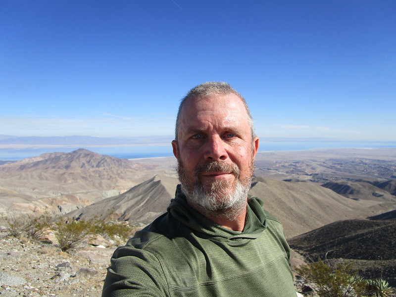
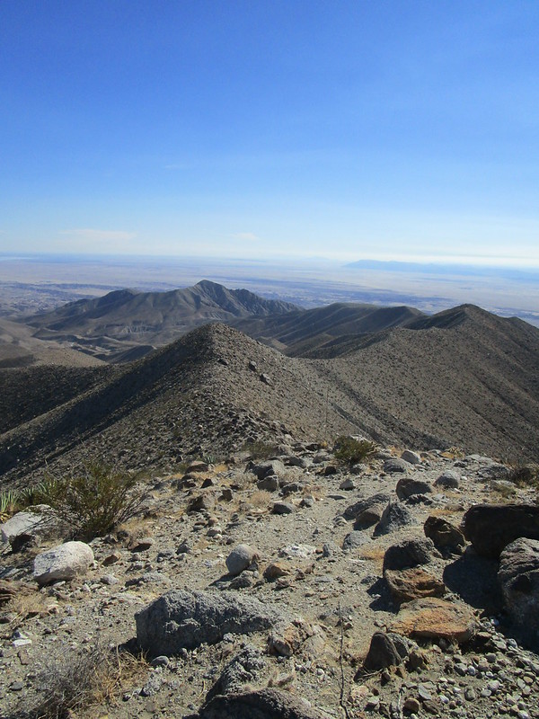
On Monday I climbed Pyramid Peak for the first time. I had tried a couple months ago via Palo Verde wash. But I lost the miner's trail a few times and generally wasn't making very good time, so I decided to leave it for another time and another route.
This time I went straight up Smoke Tree Wash, which doesn't seem like a common route (based on GPX tracks I've seen) but worked out much better for me. It had been a cold clear night of camping in Coachwhip Canyon Sunday night, but that paid off with great clear views from the peak. I just had time to get a few pics before the weather started to change with clouds rolling in.
The only obstacle going up Smoke Tree is this small easily climbed dry fall.


|
|
|
+1
link
|
|
ziphius Posts: 911
12/23/2021
|
The views from Pyramid are fantastic. Nice trip.
--
http://www.coyotelearning.org
|
|
|
link
|
|
Buford Posts: 456
12/23/2021
|
Pyramid is a fun one.
I'm surprised the miner's trail was that hard to follow. It is steep. Finding the start of it is tough out of Palo Verde, but after that it has been very easy to follow for years. Did it get washed out in a storm? I know a huge storm hit that area in March 2020 and rearranged some of the canyon bottoms. Or were you on a different mine trail? There are at least two old trails back there in Palo Verde.
--
Links to my photos: ABDSP photos, Bighorn sheep photos, ABDSP time lapse video, Wildlife photos (mainly birds)
|
|
|
link
|
|
Brian Posts: 224
12/23/2021
|
Buford wrote:
I'm surprised the miner's trail was that hard to follow. It is steep. Finding the start of it is tough out of Palo Verde, but after that it has been very easy to follow for years. Did it get washed out in a storm? I know a huge storm hit that area in March 2020 and rearranged some of the canyon bottoms. Or were you on a different mine trail? There are at least two old trails back there in Palo Verde.
It was a combination of factors. I had done Schad's Rock Tanks loop 10 years ago and remembered the miner's trail as being marked by a cairn. It wasn't there this time. Also I had downloaded a GPX track which I assumed was going to follow this trail. It took me up a dry fall and then along a canyon bottom, which wasn't terrible but was kind of slow. I didn't remember that from before, but it had been 10 years so I thought my memory was off. The track eventually converged with the real trail.
When I got home I looked on Google Earth and saw the beginning of the trail out of Palo Verde is still there just as I had remembered it, but unfortunately I wasn't on it.
In any case I decided I would prefer an approach from Smoke Tree so I wouldn't have any up hill on the return.
edited by Brian on 12/23/2021
|
|
|
link
|
|
tekewin Posts: 367
12/26/2021
|
Nice! Smoke Tree is the way I went and thought it was a good route. I got pretty far up the wash before I spotted the trail, but it was clear from there. Did you happen to swing by the rock tanks? I was just thinking they are probably holding a decent amount of water now.
|
|
|
+1
link
|
|
Brian Posts: 224
12/26/2021
|
tekewin wrote:
Nice! Smoke Tree is the way I went and thought it was a good route. I got pretty far up the wash before I spotted the trail, but it was clear from there. Did you happen to swing by the rock tanks? I was just thinking they are probably holding a decent amount of water now.
I had read a trip report where someone mentioned seeing them from the ridge, so I was looking but didn't see them. That person may have been on a different ridge. I had gone up the side canyon to see them 10 years ago and didn't do that this time.
|
|
|
+1
link
|
|
Rocko1 Posts: 596
12/27/2021
|
Looks like a great trip Brian. Fantastic views up there. What was your mileage and elevation gain/loss?
edited by Rocko1 on 12/27/2021
|
|
|
link
|
|
Brian Posts: 224
12/27/2021
|
Rocko1 wrote:
Looks like a great trip Brian. Fantastic views up there. What was your mileage and elevation gain/loss?
edited by Rocko1 on 12/27/2021
10 miles round trip / 2600'

|
|
|
+1
link
|
|
Buford Posts: 456
12/28/2021
|
If just doing Pyramid the route up Smoke Tree makes sense. Most people probably use the miner's trail out of Palo Verde Wash because they are doing a broader loop instead of just Pyramid.
There is actually an old trail from Smoke Tree that goes up and joins the ridgeline just North of Pyramid. That trail is hard to follow but one of the old hands showed it to me.
--
Links to my photos: ABDSP photos, Bighorn sheep photos, ABDSP time lapse video, Wildlife photos (mainly birds)
|
|
|
link
|
|
rockhopper Posts: 668
12/29/2021
|
I like it. The Desert is back in full hiking mode. Hiked up to the natural rock tanks and Villager a few times. Always had my eye on Pyramid and Mile high peaks. Good show man.
|
|
|
+1
link
|