|
Brian Posts: 221
1/27/2023
|
Last year I was doing a hike of the plateaus above Clark Lake and I descended the ridge that Schad recommends as an approach for a hike to Dawn's. The whole way down that steep ridge, I kept thinking "this is the last thing I'd want to be doing after summiting Dawn's." After some good advice from Sicco Rood, I decided the Rockhouse Canyon approach would be viable for me. I knew I could make it to a base camp at the base of the ridge. I wasn't fully convinced of my ability to make it up that final ridge until I was actually up there. Rocko1 improved on my game plan by coming up with a base camp part way up the ridge, meaning we would "only" have to climb 2000' on the morning of day 2. That helped a lot.
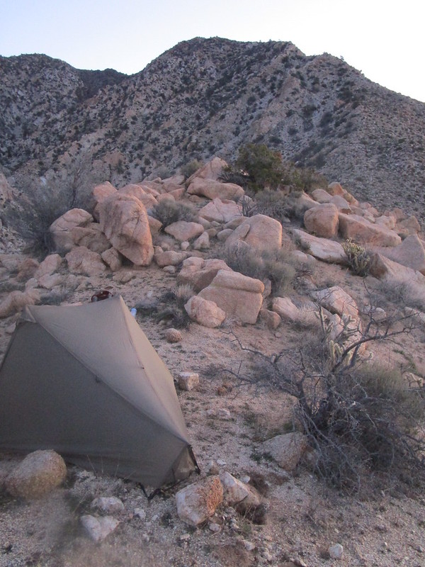
Pre-dawn view of a snowy Toro as seen from base camp. We had originally planned this trip for the previous weekend, but delayed it due to weather. Good call!

Our accommodations.

Climbing (I can't get any pics of Rocko1 climbing since he's always ahead).


The views.


edited by Brian on 1/27/2023
|
|
|
+2
link
|
|
Brian Posts: 221
1/28/2023
|
Buford wrote:
Nice. Going up the gentler Rockhouse approach must take some of the sting out of that final climb. Still, no way it is easy. Is Rockhouse longer mileage wise?
Was the register there? It was in 2019 when I did 6582, but the recent report from Tekewin indicates it disappeared.
I think the mileage would be about the same as the traditional route IF one's vehicle could make it to the road end (which is pretty screwed up right now - we didn't see any evidence of recent tire tracks for about the last 1.5 miles). Since I parked in my usual spot at the Rockhouse/Butler split, our route was 6 miles longer than the traditional route (but those extra miles are essentially road walking).
We didn't find any register. We might have spent more time looking if not for the persistent blasts of cold wind that were encouraging us to get on our way.
|
|
|
+1
link
|
|
dsefcik Administrator Posts: 2609
1/29/2023
|
I remember the register was buried at the bottom of the cairn in the rocks and was hard to find, I almost gave up looking for it the first time I went there. Perhaps it is still there and just not found.
Nice TR, wish I could have joined you.
--
http://www.sefcik.com
http://www.darensefcik.com
http://www.carrizogorge.com
|
|
|
+1
link
|
|
surfponto Administrator Posts: 1362
1/29/2023
|
The pictures from the top are awesome.
Great job.
--
https://www.anzaborrego.net/


|
|
|
+1
link
|
|
Rocko1 Posts: 588
1/31/2023
|
Was a fun trip for sure. Setting up camp at 4,600ft was a good choice as it broke up the climb into two days. A few more pics.


View from the top-https://imgur.com/kpUUq3D
Hidden Spring had water flowing out of the rock https://imgur.com/KBSZ6a3
On thing being up there really solidified is actually how far away Rabbit and Village look. Knowing how thick the brush can be it seems to be a very daunting task to get to them.
Album https://imgur.com/a/RChvH21
edited by Rocko1 on 1/31/2023
|
|
|
+1
link
|
|
Brian Posts: 221
1/31/2023
|
I forgot about that unfortunate former resident of the Hidden Springs metropolitan area.
|
|
|
+1
link
|
|
tekewin Posts: 365
2/1/2023
|
Great hike and photos! Glad you made it.
When Henry and I visited, we didn't find the register, but didn't know it was located in the base of the cairn. It might have been there. We left another in the open that maybe was removed or added to the original. These photos kind of want to make me go back, but I also remember how I felt coming down. Haha.
The bighorn carcass was a great find.
On thing being up there really solidified is actually how far away Rabbit and Village look. Knowing how thick the brush can be it seems to be a very daunting task to get to them.
Yeah, they both looked a long way off. Crazy that some people have traversed the entire ridge in one go.
|
|
|
+1
link
|
|
Rocko1 Posts: 588
2/2/2023
|
tekewin wrote:
Great hike and photos! Glad you made it.
When Henry and I visited, we didn't find the register, but didn't know it was located in the base of the cairn. It might have been there. We left another in the open that maybe was removed or added to the original. These photos kind of want to make me go back, but I also remember how I felt coming down. Haha.
The bighorn carcass was a great find.
On thing being up there really solidified is actually how far away Rabbit and Village look. Knowing how thick the brush can be it seems to be a very daunting task to get to them.
Yeah, they both looked a long way off. Crazy that some people have traversed the entire ridge in one go.
There was some broken red plastic pieces near the cairn, maybe from another register?
I was pleasantly surprised at the difficulty level of the climb was after reading all the reports. I thought I would be climbing on hands and knees but it wasn't so bad. A bit steeper than going up from Stifferino to the ridge in my opinion. 2 hours up from the 4,600ft mark with a few breaks. Maybe the northwestern ridge that we took was the easier route. I am sure day hiking I would just be wrecked.

|
|
|
+1
link
|
|
rockhopper Posts: 668
2/6/2023
|
Congrats. Great trip report. Thanks for sharing the route map. I like it!
|
|
|
+1
link
|