|
Britain Posts: 610
6/11/2017
|
Always like hiking between the 8, this is where the freeway splits going in and out of the desert. Some old mines, the DC marker on the peak and lots of big horn. This one had his eye on me. 100-400mm lens @400mm .

--
Cant drive 55
Britain
http://icorva.com
|
|
|
+1
link
|
|
kk6mbh Posts: 5
6/12/2017
|
Wow!
|
|
|
link
|
|
ziphius Posts: 911
6/12/2017
|
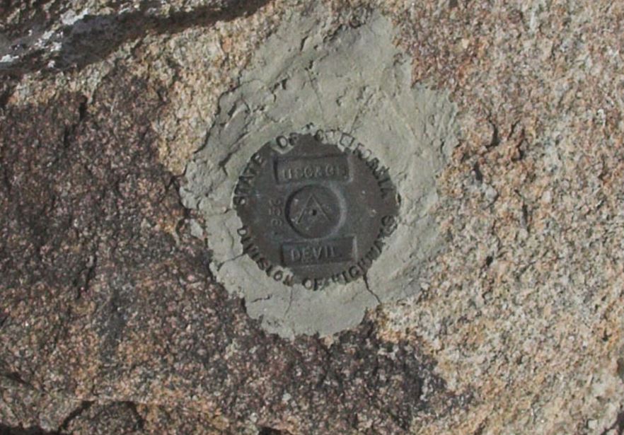
"Island" sheep, nice. Makes me wonder how often vehicle collisions occur. What is the 'DC' refer to?
edited by ziphius on 6/12/2017
--
http://www.coyotelearning.org
|
|
|
link
|
|
dsefcik Administrator Posts: 2634
6/12/2017
|
sheep are common in that area, there is water at the spring (trough) and vehicle collisions do occur....nice photo
--
http://www.sefcik.com
http://www.darensefcik.com
http://www.carrizogorge.com
|
|
|
link
|
|
tekewin Posts: 386
6/17/2017
|
Another sweet photo!
|
|
|
link
|
|
surfponto Administrator Posts: 1369
7/3/2017
|
Great photo!
Sorry have not been on the forum as much as I should. Lots of family stuff going on.
Anyway wanted to comment that I really love that area.
Daren and I explored it 5 plus years ago.
I would like to take credit for the name "The Island" but someone will probably refute it 
http://www.anzaborrego.net/2012/04/19/exploring-myer-valley-and-beyond/
Bob
edited by surfponto on 7/3/2017
--
https://www.anzaborrego.net/


|
|
|
link
|
|
ziphius Posts: 911
7/3/2017
|
I learned "Island" from this forum.  Speaking of sheep, had a great time on my 1st 'sheep count'. Zero sheep at Big Spring this year (counters had a zero in 2015 too). Met a lot of great people and we got to stare at rocks, lizards, and birds all day for 2.5 days. Speaking of sheep, had a great time on my 1st 'sheep count'. Zero sheep at Big Spring this year (counters had a zero in 2015 too). Met a lot of great people and we got to stare at rocks, lizards, and birds all day for 2.5 days.
surfponto wrote:
Great photo!
Sorry have not been on the forum as much as I should. Lots of family stuff going on.
Anyway wanted to comment that I really love that area.
Daren and I explored it 5 plus years ago.
I would like to take credit for the name "The Island" but someone will probably refute it
http://www.anzaborrego.net/2012/04/19/exploring-myer-valley-and-beyond/
Bob
edited by surfponto on 7/3/2017
--
http://www.coyotelearning.org
|
|
|
link
|
|
Britain Posts: 610
7/5/2017
|
ziphius wrote:
"Island" sheep, nice. Makes me wonder how often vehicle collisions occur. What is the 'DC' refer to?
edited by ziphius on 6/12/2017
The highest peak in the island has the DC marker ( Devils Canyon-Peak)
Heres my little write up between .
http://www.icorva.com/index.php/2013-03-23-20-44-53/2013-04-20-02-04-08/2013-03-23-20-37-36/back-packing/7-between-the-8
edited by Britain on 7/5/2017
edited by Britain on 7/5/2017
--
Cant drive 55
Britain
http://icorva.com
|
|
|
link
|
|
dsefcik Administrator Posts: 2634
7/5/2017
|
I went out yesterday and hiked the loop from the island down the canyon, under the bridge and then back out near the spring....it was kinda hot out there. Was hoping to see some sheep, I was packing the 600mm lens but did not see any, just several iguanas and lizards and some hawks screeching in the high noon sky...didn't even see the BP. I need to spend some more time exploring that area, it is a fascinating place.
--
http://www.sefcik.com
http://www.darensefcik.com
http://www.carrizogorge.com
|
|
|
link
|
|
Britain Posts: 610
7/5/2017
|
dsefcik wrote:
I went out yesterday and hiked the loop from the island down the canyon, under the bridge and then back out near the spring....it was kinda hot out there. Was hoping to see some sheep, I was packing the 600mm lens but did not see any, just several iguanas and lizards and some hawks screeching in the high noon sky...didn't even see the BP. I need to spend some more time exploring that area, it is a fascinating place.
That canyon is infested with ticks. Been also on the mountain ridge which is on the west side of 8 before mountain springs. More deer on that side then Big Horn. There's a big cat also. That's why I asking what camera you were using.
edited by Britain on 7/5/2017
--
Cant drive 55
Britain
http://icorva.com
|
|
|
link
|
|
Britain Posts: 610
7/5/2017
|
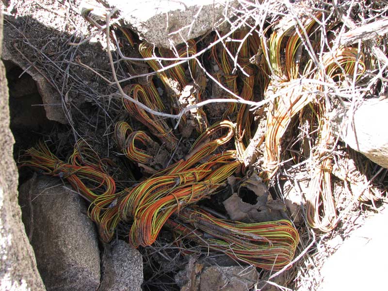
Devils Canyon, per BP used to be a pick up area for illegals. They would wait in the canyon and when the time came drop their stuff and scramble up to the freeway for the ride. That the reason for all the backpacks that used to be down there. In 2002 I ran into some BP with their shirts off trying to rid the ticks from them. Same year I found these explosives. The detonators per ID where from Germany around 1890-1900. I didn't know they had electrical ones back then. Up to 1978 when the hurricane came through you could almost drive a car through per some long term locals. There also are some ruins that are over looked. I thought at first was it the toll station but I think that is in mountain springs. Bada boom. Let the BLM know and they came in cleared them out.
--
Cant drive 55
Britain
http://icorva.com
|
|
|
link
|
|
dsefcik Administrator Posts: 2634
7/5/2017
|
Personally I blame the Tamarisk, the whole Jacumba/Carrizo area is infested with Tamarisk and ticks. Too many trips in Carrizo have left me with 4,5,6 or more ticks in a single day. I was talking with some BP once out in Myer and a younger one commented about the ticks whenever they patrolled the island area. Devils Cyn had a lot of Tamarisk growing...just MHO....
--
http://www.sefcik.com
http://www.darensefcik.com
http://www.carrizogorge.com
|
|
|
link
|
|
Britain Posts: 610
7/5/2017
|
Your probably correct, every time I go through any brush I look for those hitchhikers on me !
--
Cant drive 55
Britain
http://icorva.com
|
|
|
link
|
|
rockhopper Posts: 678
7/6/2017
|
All these stories of ticks reminds me of the back side of Palomar Mtn. I was covered with Deer ticks hiking up to Agua Tibia. Once I was sleeping on ground on the PCT south of Red Tahquitz when I was bolted awake by ticks on my neck! Tent from that day forward. Sounds like I need to hike out to the "island" area at I-8. It's near a main trail that heads towards the coast. Used for for thousands of years by the Native Americans.
edited by rockhopper on 7/6/2017
|
|
|
link
|
|
Britain Posts: 610
7/6/2017
|
rockhopper wrote:
All these stories of ticks reminds me of the back side of Palomar Mtn. I was covered with Deer ticks hiking up to Agua Tibia. Once I was sleeping on ground on the PCT south of Red Tahquitz when I was bolted awake by ticks on my neck! Tent from that day forward. Sounds like I need to hike out to the "island" area at I-8. It's near a main trail that heads towards the coast. Used for for thousands of years by the Native Americans.
edited by rockhopper on 7/6/2017
Interesting in 2002 I was photographing this area for a native American trail named the Yuma trail, a trail from mission bay to the river area at Yuma. I came across the Yuma to San Diego turnpike and thought perhaps I was wrong. Where can I find information on your trail?
--
Cant drive 55
Britain
http://icorva.com
|
|
|
link
|
|
rockhopper Posts: 678
7/9/2017
|
Britain wrote:
rockhopper wrote:
All these stories of ticks reminds me of the back side of Palomar Mtn. I was covered with Deer ticks hiking up to Agua Tibia. Once I was sleeping on ground on the PCT south of Red Tahquitz when I was bolted awake by ticks on my neck! Tent from that day forward. Sounds like I need to hike out to the "island" area at I-8. It's near a main trail that heads towards the coast. Used for for thousands of years by the Native Americans.
edited by rockhopper on 7/6/2017
Interesting in 2002 I was photographing this area for a native American trail named the Yuma trail, a trail from mission bay to the river area at Yuma. I came across the Yuma to San Diego turnpike and thought perhaps I was wrong. Where can I find information on your trail?
Hi Britain,
It is my understanding the major East-West cooridor used for thousands of years at the southern part of the county is basically under or near old I-80 following the springs and water sources ( dug out wells) from the desert toward the coast. It was not uncommon for these Native Americans to travel on foot over 40 miles in one day carrying their gear wearing only deer skin or woven foot ware. Tough!
edited by rockhopper on 7/9/2017
|
|
|
link
|
|
Britain Posts: 610
7/9/2017
|
All Righty then. I've been reading how springs are drying up. That swampy area where the overland stage runs through near Valllecito wash has dried up, noticed that a couple years ago. Its always has had water in it. You can still dig in some of the washes near the Yuha wells and get water though.
--
Cant drive 55
Britain
http://icorva.com
|
|
|
link
|