|
dsefcik Administrator Posts: 2634
8/20/2017
|
copy/pasted from my blog
I found one of the mines Britain mentioned but not the other, I think I missed it by a couple hundred feet...next time!
==================================
The Island - Inko BM
Headed back out to The Island yesterday to try and find the Inko Benchmark. It is one of several that are not marked on most maps but can be found as peak 2222 on the USGS topo maps. It was another hot day out, probably 100+ again. I parked where some shooting debris was and headed up into the boulders eventually picking up an old indian trail that had several roasting pits along the way. Some great views and this was another seldom visited BM as the register was only 2 small pages with a few sign ins....Monday Manics strike again.


Most of the route was straight thru SDG&E power lines, this is some rugged terrain.


Here is one of the hadnful of roasting pits I found with the powerline tower in the background

Great views up on the Inko peak, here is looking at the windfarm in Ocotillo

Highway 8 west and Devil BM peak

Here is looking south at Myer Valley and Slant Peak

There was one mine pit near the peak, there is supposed to be another but I did not see it.

Pottery, slicks, mortars, metates, etc all checked in this trip as well


Wildlife noted were a variety of birds, lizards, antelope squirrels, the rest had the good sense to hide in the shade for the day.
Total Mylar balloons this trip - 0 (we must be making a dent in them!)
----
--
http://www.sefcik.com
http://www.darensefcik.com
http://www.carrizogorge.com
|
|
|
link
|
|
Britain Posts: 611
8/20/2017
|
Ok Roasting pit. Seen a few.
--
Cant drive 55
Britain
http://icorva.com
|
|
|
link
|
|
rockhopper Posts: 678
8/21/2017
|
Daren, that island area and the area in general was one of the major Native American trail/ trading route from the Colorado River to the Pacific coast. It's no surprise that there are still artifacts present. The trail followed springs and walk in wells along the route. I read somewhere that a lot of the main trail is under Hwy 80 and I-8.
|
|
|
link
|
|
ziphius Posts: 911
8/21/2017
|
Daren, any bighorn 'sign'?
--
http://www.coyotelearning.org
|
|
|
link
|
|
dsefcik Administrator Posts: 2634
8/21/2017
|
ziphius wrote:
Daren, any bighorn 'sign'? Only some day old droppings here and there...
--
http://www.sefcik.com
http://www.darensefcik.com
http://www.carrizogorge.com
|
|
|
link
|
|
Britain Posts: 611
8/25/2017
|
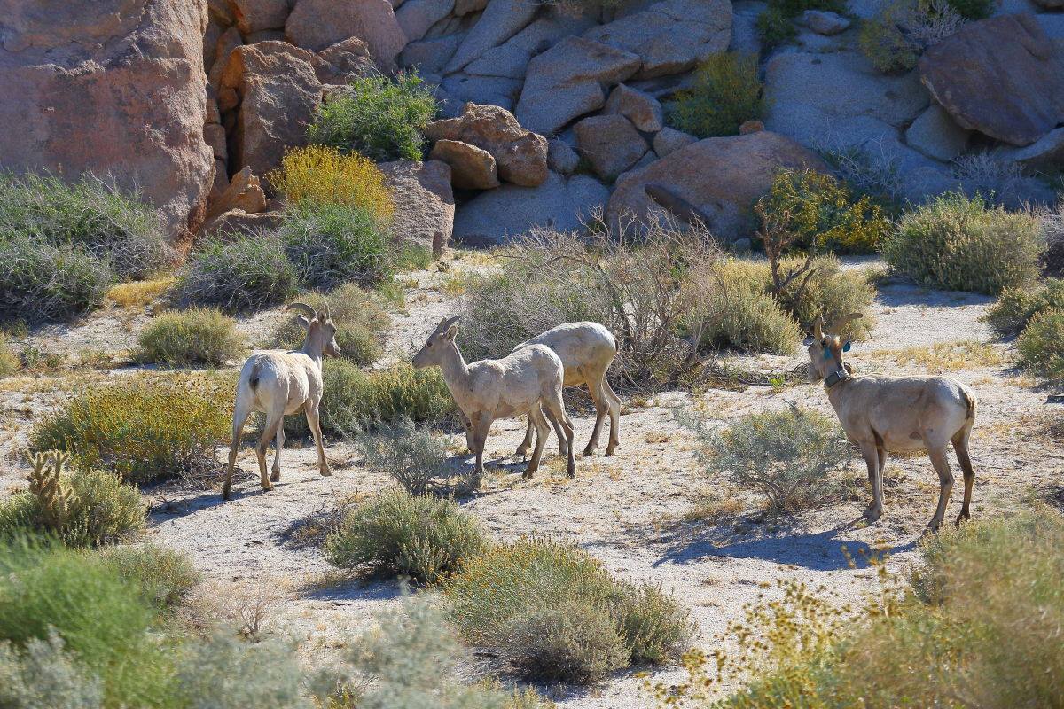
I caught these guys up on the eastern mesa of Table Mountain. One is tagged. I saw the same bunch a month earlier at the lower bridge on 8. Picture was taken early May.
--
Cant drive 55
Britain
http://icorva.com
|
|
|
link
|
|
tommy750 Posts: 1086
8/25/2017
|
Britain wrote:
I caught these guys up on the eastern mesa of Table Mountain. One is tagged. I saw the same bunch a month earlier at the lower bridge on 8. Picture was taken early May.
Nice pic, Britain. Was up in that same area in 2014 and have pics of green and red tagged ewes but not your blue one. Glad to see babies.
|
|
|
link
|
|
Britain Posts: 611
8/27/2017
|
Well they are not easy to find and photo. I see them from a distance and it seldom at least for me to catch them close-up. I've packed the area from 8 were Devils goes under the freeway all the way up to Table in all directions. This year I'll go Eastern Table mountain down to Montero palms to see whats in that area or go up from Montero palms.
--
Cant drive 55
Britain
http://icorva.com
|
|
|
link
|