|
tommy750 Posts: 1086
5/31/2020
|
Got a relatively inexpensive drone (Mavic Mini) recently to see how the desert looks from above. Went out on several trips this month to photograph known cultural sites and a couple things I found on GE that may or may not be "real." Would rate my drone flying skills as comparable to a teenager on Day 1 of Driver's Ed but haven't crashed it yet so happy about that. All of the pics are non ABDSP
Here's an archaic site near Ocotillo described by Begole back in the 70's.
 IMP-110 by tomteske, on Flickr IMP-110 by tomteske, on Flickr
Tool were typically rather large and crude and pottery/small projectile points many years in the future. Here's a couple stone tools still lying on the ground. Both are made of the commonly used green porphyric metavolcanic (that green spotted stuff) rock and both heavily patinated indicating they've been there a long time.
 IMP-110 Tool by tomteske, on Flickr IMP-110 Tool by tomteske, on Flickr
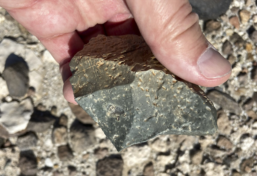 IMP-110 Tool2 by tomteske, on Flickr IMP-110 Tool2 by tomteske, on Flickr
Was pretty sure I'd found a new geoglyph when I spotted this guy but apparently it has previously been recorded and is associated with a large quarry site for, you guessed it, porphyritic green metavolcanic rock. The geoglyph is a serpentine line about 65-70 meters long. Tire tracks are in the top middle of the pic.
 Geoglyph Drone by tomteske, on Flickr Geoglyph Drone by tomteske, on Flickr
 Geoglyph by tomteske, on Flickr Geoglyph by tomteske, on Flickr
 Geoglyph2 by tomteske, on Flickr Geoglyph2 by tomteske, on Flickr
I think this is a geoglyph that was transected by Old Hwy 80 years ago and even more so by I-8.
 Geoglyph by tomteske, on Flickr Geoglyph by tomteske, on Flickr
Nearby cleared circles on a bench overlooking the Ocotillo area.
 Rock Circles by tomteske, on Flickr Rock Circles by tomteske, on Flickr
A large cleared cicle with a smaller rock circle in the perimetry on a bench overlooking Ocotillo.
 Rock Circle2 by tomteske, on Flickr Rock Circle2 by tomteske, on Flickr
 Rock Circle by tomteske, on Flickr Rock Circle by tomteske, on Flickr
Went out today and took pics of the lake bed of Ancient Lake Cahuilla. Definitely a different perspective.
 Red Onions by tomteske, on Flickr Red Onions by tomteske, on Flickr
 Red Onions3 by tomteske, on Flickr Red Onions3 by tomteske, on Flickr
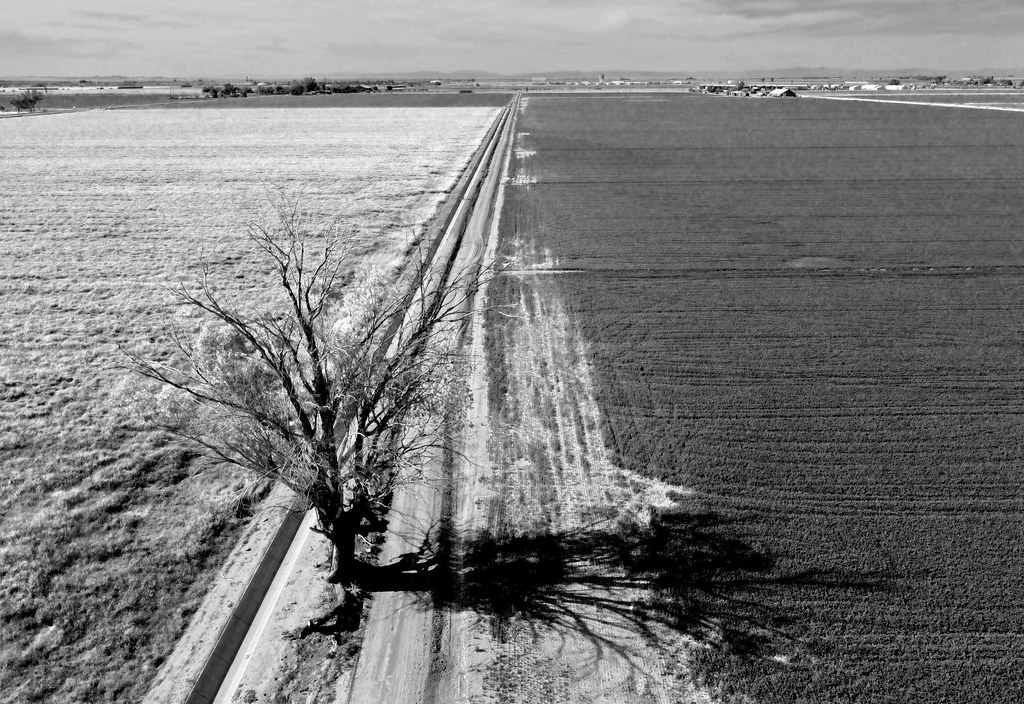 Tree on Canal Bank by tomteske, on Flickr Tree on Canal Bank by tomteske, on Flickr
If you can't fathom how the Imperial Valley can use 2M acre feet of Colorado River water every year, wonder no longer.
 River Water2 by tomteske, on Flickr River Water2 by tomteske, on Flickr
 River Water by tomteske, on Flickr River Water by tomteske, on Flickr
Would really like to do more drone photography with a nicer camera after I learn how to not crash. Shows a completely unique perspective of what we've seen a million times. Enjoy! Tom
|
|
|
+2
link
|
|
Scooter Posts: 114
5/31/2020
|
Thank you for a very interesting trip report. It sure has been a slow spring in the desert and on the blog. Thanks Again
|
|
|
link
|
|
Rocko1 Posts: 622
6/1/2020
|
Tommy you have a fantastic eye for finding things! Great pictures and finds. I have considered a drone but have reservations after being out in nature and having them buzz around near me-the noise can be quite off putting.
|
|
|
link
|
|
tommy750 Posts: 1086
6/1/2020
|
Scooter wrote:
Thank you for a very interesting trip report. It sure has been a slow spring in the desert and on the blog. Thanks Again
2020 sure has been a terrible year for just about everything including enjoying the desert. Hopefully things will change soon
|
|
|
link
|
|
tommy750 Posts: 1086
6/1/2020
|
Rocko1 wrote:
Tommy you have a fantastic eye for finding things! Great pictures and finds. I have considered a drone but have reservations after being out in nature and having them buzz around near me-the noise can be quite off putting.
Agree, those yahoos flying drones all over public spaces or 2 ft away from the wildlife need to stay away. That said, really think it would be a great addition to park volunteers needing to document change over time at sensitive cultural sites. For example, just noticed by drone photos someone had been substantially altering a well known spoked wheel geoglyph near Ocotillo in the past years. Changes were made to another rather obscure geoglyph as well. Do-gooders? Kumeyaay? I don't know, but I forwarded the info to BLM for follow up. Not sure what the sheep counters would have to say about drones as a supplemental viewing platform. Drones can be annoying and noisy but many including mine are rather invisible and inaudible at about 50 ft overhead and may not be an issue for careful wildlife observers.
One last thing. I never have GPS enabled for cameras and phones but your drone will. Had to remind myself to remove all GPS data from pics of sensitive sites.
|
|
|
+2
link
|
|
dsefcik Administrator Posts: 2634
6/1/2020
|
I like those red onion pics and the other IV pics also, nice work tommy750..
===
--
http://www.sefcik.com
http://www.darensefcik.com
http://www.carrizogorge.com
|
|
|
link
|
|
Buford Posts: 468
6/1/2020
|
Nice. I actually enjoy the pictures as much as I find drones obnoxious.
I saw someone flying a drone within feet over an active peregrine nest this weekend. I don’t know if they knew the nest was there. Sadly the falcons didn’t take out the drone for our entertainment.
--
Links to my photos: ABDSP photos, Bighorn sheep photos, ABDSP time lapse video, Wildlife photos (mainly birds)
|
|
|
+1
link
|
|
deborah Posts: 115
6/2/2020
|
It does give a really interesting perspective. Thanks for sharing!
|
|
|
link
|
|
ziphius Posts: 911
6/2/2020
|
Love the photos. Thanks for being a responsible drone operator and keeping it out of the park. Drones are like dogs, great.... but too many people own them. If you eventually want to upgrade to a fancier camera and a bigger system, Don Leroi at Aerial Imaging Systems builds a bunch of hexacopters for NOAA to photograph whales, sea lions, and penguins. We use mainly Sony mirrorless cameras on our systems. https://aerialimagingsolutions.com
Their training for these systems are taken seriously, FAA certification required. https://aerialimagingsolutions.com/training/
edited by ziphius on 6/2/2020
--
http://www.coyotelearning.org
|
|
|
+1
link
|
|
tommy750 Posts: 1086
6/2/2020
|
Sound like everyone is in agreement drones are awesome and terrible depending on how they're used. Ziphius, nice article on seal counting. My cheap drone camera now has more MP than the one in your article which is from 2011. Your Sony mirrorless setup is probably a completely different story! My little drone in intentionally 249 grams, one less than required for an FAA certificate which is .55 to 55lbs.
What interests me the most is high resolution panoramas and I think our area has a lot of possibilities.
|
|
|
+1
link
|
|
rockhopper Posts: 678
6/4/2020
|
Nice finds. Neat adventure Tommy! Were the camping circles on the benches above the ancient lake shore line? The multiple lake fills over the past 12,000 years ( At least 8 full fills but probably many more) supported large populations at various periods of lake fills. Lake fills may have lasted 50 years or more with constant inflows from the Colorado river. Population peak may have reached 10,000 around the lake. Those stone tools could be 1000 years old or 10,000 years old.
|
|
|
+1
link
|
|
Rocko1 Posts: 622
6/4/2020
|
tommy750 wrote:
Sound like everyone is in agreement drones are awesome and terrible depending on how they're used. Ziphius, nice article on seal counting. My cheap drone camera now has more MP than the one in your article which is from 2011. Your Sony mirrorless setup is probably a completely different story! My little drone in intentionally 249 grams, one less than required for an FAA certificate which is .55 to 55lbs.
What interests me the most is high resolution panoramas and I think our area has a lot of possibilities.
What is your drones MP count Tommy? Some high res panos would be pretty fantastic.
|
|
|
link
|
|
ziphius Posts: 911
6/5/2020
|
Tommy yeah the article is a little outdated! We're using a 36 MP Sony A7R on a hexacopter these days.
--
http://www.coyotelearning.org
|
|
|
link
|
|
tommy750 Posts: 1086
6/5/2020
|
rockhopper wrote:
Nice finds. Neat adventure Tommy! Were the camping circles on the benches above the ancient lake shore line? The multiple lake fills over the past 12,000 years ( At least 8 full fills but probably many more) supported large populations at various periods of lake fills. Lake fills may have lasted 50 years or more with constant inflows from the Colorado river. Population peak may have reached 10,000 around the lake. Those stone tools could be 1000 years old or 10,000 years old.
Was exploring around Ocotillo and SW of the Coyote Mts. Lots of reported Archaic sites in that area. The Park spent a lot of time last year excavating such a site near Carrizo. The history of early man in this area is quite fascinating. The earliest first man site in San Diego is probably beneath the fancy homes south of the La Jolla Beach and Tennis Club. Just finished reading this book on the subject and would definitely recommend it for those interested in the topic: https://sunbeltpublications.com/shop/first-people/
|
|
|
link
|
|
tommy750 Posts: 1086
6/5/2020
|
Rocko1 wrote:
tommy750 wrote:
Sound like everyone is in agreement drones are awesome and terrible depending on how they're used. Ziphius, nice article on seal counting. My cheap drone camera now has more MP than the one in your article which is from 2011. Your Sony mirrorless setup is probably a completely different story! My little drone in intentionally 249 grams, one less than required for an FAA certificate which is .55 to 55lbs.
What interests me the most is high resolution panoramas and I think our area has a lot of possibilities.
What is your drones MP count Tommy? Some high res panos would be pretty fantastic.
Mine is 12.7MP and not bad for the price. Definitely could stitch a few pics together in Photoshop for a decent pano.
|
|
|
+1
link
|
|
tommy750 Posts: 1086
6/5/2020
|
ziphius wrote:
Tommy yeah the article is a little outdated! We're using a 36 MP Sony A7R on a hexacopter these days.
You have any pics you could post from your work with that setup?? Would be very interesting to see.
|
|
|
+1
link
|
|
Rocko1 Posts: 622
6/5/2020
|
tommy750 wrote:
Rocko1 wrote:
tommy750 wrote:
Sound like everyone is in agreement drones are awesome and terrible depending on how they're used. Ziphius, nice article on seal counting. My cheap drone camera now has more MP than the one in your article which is from 2011. Your Sony mirrorless setup is probably a completely different story! My little drone in intentionally 249 grams, one less than required for an FAA certificate which is .55 to 55lbs.
What interests me the most is high resolution panoramas and I think our area has a lot of possibilities.
What is your drones MP count Tommy? Some high res panos would be pretty fantastic.
Mine is 12.7MP and not bad for the price. Definitely could stitch a few pics together in Photoshop for a decent pano.
Thanks. It does give a great perspective.
|
|
|
link
|
|
ziphius Posts: 911
6/5/2020
|

Gray whales from 150 ft altitude. Custom hexacopter with Sony A7R mirrorless body.
tommy750 wrote:
ziphius wrote:
Tommy yeah the article is a little outdated! We're using a 36 MP Sony A7R on a hexacopter these days.
You have any pics you could post from your work with that setup?? Would be very interesting to see.
edited by ziphius on 6/5/2020
--
http://www.coyotelearning.org
|
|
|
+1
link
|
|
tommy750 Posts: 1086
6/5/2020
|
ziphius wrote:
Gray whales from 150 ft altitude. Custom hexacopter with Sony A7R mirrorless body.
tommy750 wrote:
ziphius wrote:
Tommy yeah the article is a little outdated! We're using a 36 MP Sony A7R on a hexacopter these days.
You have any pics you could post from your work with that setup?? Would be very interesting to see.
edited by ziphius on 6/5/2020
So Ziphius you get paid to do this stuff?? Dang. Guess some of us got those good guidance couselers 
|
|
|
link
|
|
Britain Posts: 611
6/5/2020
|
DJi makes some good drones. I was thinking about doing the same as Tommy. Just to see what something looks like from above.
--
Cant drive 55
Britain
http://icorva.com
|
|
|
link
|
|
ziphius Posts: 911
6/6/2020
|
Tommy, I don't get to pilot the UAVs, I'm one of the "whale finders" that helps direct the UAV towards the whales. It's kind of like sheep-counting, wait around for hours while nothing happens, and then something happens.
tommy750 wrote:
So Ziphius you get paid to do this stuff?? Dang. Guess some of us got those good guidance couselers 
edited by ziphius on 6/6/2020
edited by ziphius on 6/6/2020
--
http://www.coyotelearning.org
|
|
|
link
|
|
rockhopper Posts: 678
6/8/2020
|
tommy750 wrote:
rockhopper wrote:
Nice finds. Neat adventure Tommy! Were the camping circles on the benches above the ancient lake shore line? The multiple lake fills over the past 12,000 years ( At least 8 full fills but probably many more) supported large populations at various periods of lake fills. Lake fills may have lasted 50 years or more with constant inflows from the Colorado river. Population peak may have reached 10,000 around the lake. Those stone tools could be 1000 years old or 10,000 years old.
Was exploring around Ocotillo and SW of the Coyote Mts. Lots of reported Archaic sites in that area. The Park spent a lot of time last year excavating such a site near Carrizo. The history of early man in this area is quite fascinating. The earliest first man site in San Diego is probably beneath the fancy homes south of the La Jolla Beach and Tennis Club. Just finished reading this book on the subject and would definitely recommend it for those interested in the topic: https://sunbeltpublications.com/shop/first-people/
Thanks for the publication heads up. Will add this to my library. Looks like a collaboration of the latest information in our So Cal. area.
Quick relative story. Having been in the construction industry for nearing 40 years. I have seen a lot of excavations. Our company spent around 10 years doing remodels and new construction in the La Jolla / Mt. Soladad and Spindrift areas. The city required archaeological and seismic study trenches cut on the properties for inspection. Every excavation in the Spindrift area was full of shell middens, fire hearths and stone tools going back thousands of years. Many were deep.
Elsewhere up the coast I found a shell midden, mammal bones with charcoal 20 feet deep!
"Quite fascinating" is a great discription.
edited by rockhopper on 6/8/2020
edited by rockhopper on 6/8/2020
|
|
|
link
|
|
Rocko1 Posts: 622
6/8/2020
|
rockhopper wrote:
tommy750 wrote:
rockhopper wrote:
Nice finds. Neat adventure Tommy! Were the camping circles on the benches above the ancient lake shore line? The multiple lake fills over the past 12,000 years ( At least 8 full fills but probably many more) supported large populations at various periods of lake fills. Lake fills may have lasted 50 years or more with constant inflows from the Colorado river. Population peak may have reached 10,000 around the lake. Those stone tools could be 1000 years old or 10,000 years old.
Was exploring around Ocotillo and SW of the Coyote Mts. Lots of reported Archaic sites in that area. The Park spent a lot of time last year excavating such a site near Carrizo. The history of early man in this area is quite fascinating. The earliest first man site in San Diego is probably beneath the fancy homes south of the La Jolla Beach and Tennis Club. Just finished reading this book on the subject and would definitely recommend it for those interested in the topic: https://sunbeltpublications.com/shop/first-people/
Thanks for the publication heads up. Will add this to my library. Looks like a collaboration of the latest information in our So Cal. area.
Quick relative story. Having been in the construction industry for nearing 40 years. I have seen a lot of excavations. Our company spent around 10 years doing remodels and new construction in the La Jolla / Mt. Soladad and Spindrift areas. The city required archaeological and seismic study trenches cut on the properties for inspection. Every excavation in the Spindrift area was full of shell middens, fire hearths and stone tools going back thousands of years. Many were deep.
Elsewhere up the coast I found a shell midden, mammal bones with charcoal 20 feet deep!
"Quite fascinating" is a great discription.
edited by rockhopper on 6/8/2020
edited by rockhopper on 6/8/2020
Interesting! Our company is doing a remodel in La Jolla and we are dealing this now. The footings are only 12-24" deep maybe a total of 100LF but the archaeologist is still required to inspect.
|
|
|
link
|
|
tommy750 Posts: 1086
6/9/2020
|
If you search "La Jolla Archaeological Area" or "Spindrift Archaeological District" you get a few hits on archaeology reports generated in association with La Jolla Shores area building permits. They're an interesting read. Here's a pic from Gallegos' book showing where the Spindrift site is located. Reported C14 dating of midden deposits is as far back as 9000 years before present with midden deposits 1-8 feet thick. The site has experienced continuous occupation over that extended period because who wouldn't want to live on Spindrift Drive?
 W-1 Spindrift by tomteske, on Flickr W-1 Spindrift by tomteske, on Flickr
|
|
|
link
|
|
ziphius Posts: 911
6/10/2020
|
There is this sign on the Scripps Institution of Oceanography campus as well. https://images.app.goo.gl/fMmz5J5RrYaXcSUZA
edited by ziphius on 6/10/2020
--
http://www.coyotelearning.org
|
|
|
link
|
|
Rocko1 Posts: 622
6/10/2020
|
tommy750 wrote:
If you search "La Jolla Archaeological Area" or "Spindrift Archaeological District" you get a few hits on archaeology reports generated in association with La Jolla Shores area building permits. They're an interesting read. Here's a pic from Gallegos' book showing where the Spindrift site is located. Reported C14 dating of midden deposits is as far back as 9000 years before present with midden deposits 1-8 feet thick. The site has experienced continuous occupation over that extended period because who wouldn't want to live on Spindrift Drive?
W-1 Spindrift by tomteske, on Flickr
Ha-the house we are working on is in the middle of the lower red circle. Makes sense.
|
|
|
link
|
|
rockhopper Posts: 678
6/17/2020
|
Rocko1 wrote:
tommy750 wrote:
If you search "La Jolla Archaeological Area" or "Spindrift Archaeological District" you get a few hits on archaeology reports generated in association with La Jolla Shores area building permits. They're an interesting read. Here's a pic from Gallegos' book showing where the Spindrift site is located. Reported C14 dating of midden deposits is as far back as 9000 years before present with midden deposits 1-8 feet thick. The site has experienced continuous occupation over that extended period because who wouldn't want to live on Spindrift Drive?
W-1 Spindrift by tomteske, on Flickr
Ha-the house we are working on is in the middle of the lower red circle. Makes sense.
Back in the 1990's our company ( Foundation / Structural Engineering / Construction) worked on the bluff house to the left of the top of the red outline. We had to excavate with Archaeology reps on site . Neat info that the Tennis pond was a former lagoon marsh. Great forum. Always learning something new.
|
|
|
link
|
|
rockhopper Posts: 678
6/17/2020
|
Tommy. Book is on order. Looking forward to adding to the Library. On topic, Back in the 80's during my "Surfing Years" we would see scuba divers coming out of the ocean with stone tools and grinding metates from off shore. This was in the N. County near Encinitas. The divers could only go so deep so alot is still out there. 10,000 years ago the shore line was around 300 feet lower and up to miles out from the current shore line. At the Spindrift site in La Jolla the ocean bottom drops off quickly and the old shore line was only a few hundred yards out.
|
|
|
link
|
|
Rocko1 Posts: 622
6/17/2020
|
rockhopper wrote:
Rocko1 wrote:
tommy750 wrote:
If you search "La Jolla Archaeological Area" or "Spindrift Archaeological District" you get a few hits on archaeology reports generated in association with La Jolla Shores area building permits. They're an interesting read. Here's a pic from Gallegos' book showing where the Spindrift site is located. Reported C14 dating of midden deposits is as far back as 9000 years before present with midden deposits 1-8 feet thick. The site has experienced continuous occupation over that extended period because who wouldn't want to live on Spindrift Drive?
W-1 Spindrift by tomteske, on Flickr
Ha-the house we are working on is in the middle of the lower red circle. Makes sense.
Back in the 1990's our company ( Foundation / Structural Engineering / Construction) worked on the bluff house to the left of the top of the red outline. We had to excavate with Archaeology reps on site . Neat info that the Tennis pond was a former lagoon marsh. Great forum. Always learning something new.
Interesting. We have to have archaeologist and native representative approve the dig and site.
|
|
|
link
|
|
tommy750 Posts: 1086
6/18/2020
|
rockhopper wrote:
Tommy. Book is on order. Looking forward to adding to the Library. On topic, Back in the 80's during my "Surfing Years" we would see scuba divers coming out of the ocean with stone tools and grinding metates from off shore. This was in the N. County near Encinitas. The divers could only go so deep so alot is still out there. 10,000 years ago the shore line was around 300 feet lower and up to miles out from the current shore line. At the Spindrift site in La Jolla the ocean bottom drops off quickly and the old shore line was only a few hundred yards out.
Here's an interesting article on La Jolla off shore archaeology. Fascinating stuff.
https://www.lajollalight.com/news/health-science/sd-scripps-center-marine-archaeology-20170803-story.html
|
|
|
+1
link
|
|
rockhopper Posts: 678
6/19/2020
|
Very interesting. The whole under water archaeological community will no doubt "bring up" new pieces to the puzzle of the history human occupation of our area. I always thought whole different civilizations came and went along the coast, the mountains and the desert. The oldest clues seem to be underwater up to miles off shore all along the San Diego county coast and up to 300 feet below the surface. I need a submarine. Sign me up!
|
|
|
+1
link
|