|
tommy750 Posts: 1086
11/6/2022
|
Yoks invited Gary, Randy and me to join him on a 2-3 day BP trip to explore the Chris Lucia rock house mentioned in Rockhopper's post here: http://www.anzaborrego.net/anzaborrego/Forum/topic1386-santa-rosas-prospectors-rock-house.aspx Rockhopper has some nice videos of the area on his YouTube channel. Wade, a friend of the group mentioned another large site up nearby Alamo Canyon and we decided to visit this site as well. After some weather and work related delays, we headed out last weekend. Parking is a bit of a challenge due to private property issues. We ended up parking on Fillmore south of 78th and had no problems. The trail starts as a dirt road and transitions into an apparent wide pack animal route that is braided with an old Cahuilla trail. Gary and Yoks near the trail start:
 IMG_1536 by tomteske, on Flickr IMG_1536 by tomteske, on Flickr
Never seen a trail as heavily ducked as this one but didn't mind it on the way out at dusk. Assuming this is the route used by Rabbit peakbaggers attempting the east approach?
?Nice find at a trail side dump 
 IMG_1532 by tomteske, on Flickr IMG_1532 by tomteske, on Flickr
Randy with the rare rainbow unicorn mylar cluster.
 IMG_1547 by tomteske, on Flickr IMG_1547 by tomteske, on Flickr
Nice pot drop just off the trail.
 IMG_1560 by tomteske, on Flickr IMG_1560 by tomteske, on Flickr
Yoks with a painted sherd.
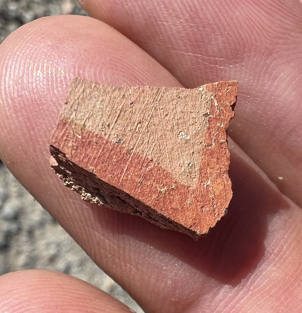 IMG_1552 by tomteske, on Flickr IMG_1552 by tomteske, on Flickr
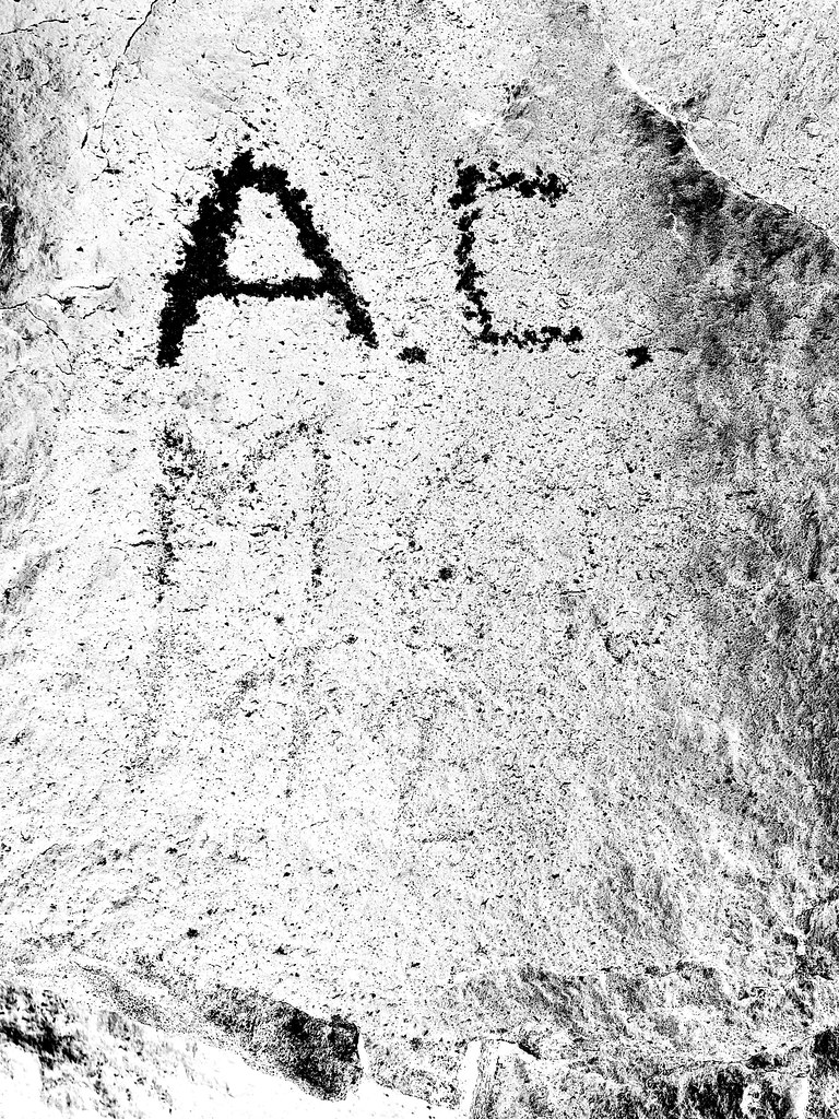
We spent lunchtime near a boulder pile with historical graffiti. Had a hard time even with PS of making out what the faded stuff said.
 IMG_1567 by tomteske, on Flickr IMG_1567 by tomteske, on Flickr
 IMG_1732 by tomteske, on Flickr IMG_1732 by tomteske, on Flickr
 IMG_1568 by tomteske, on Flickr IMG_1568 by tomteske, on Flickr
Nice train intersection! We made a left here.
 IMG_1579 by tomteske, on Flickr IMG_1579 by tomteske, on Flickr
Yoks leading the way.
 IMG_1584 by tomteske, on Flickr IMG_1584 by tomteske, on Flickr
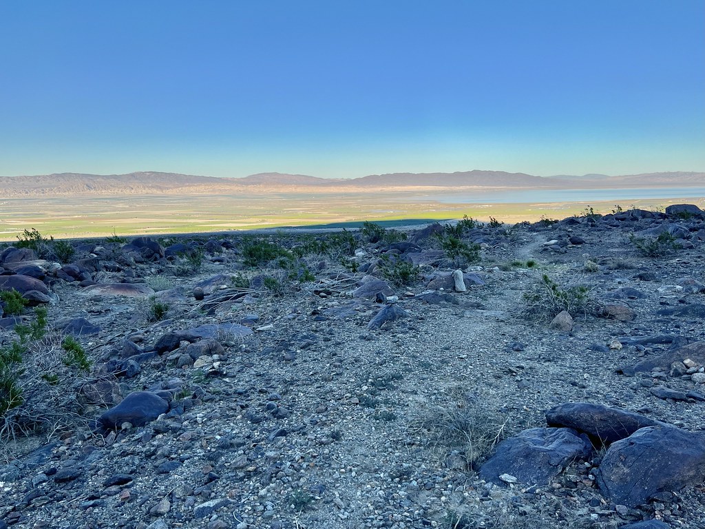
We decided to spend the night on top of this ridge with panoramic views (and cell service).
 IMG_1585 by tomteske, on Flickr IMG_1585 by tomteske, on Flickr
Yours truly after making it up to camp 1 with the lightest pack of the group at 37lb.
 IMG_1587 by tomteske, on Flickr IMG_1587 by tomteske, on Flickr
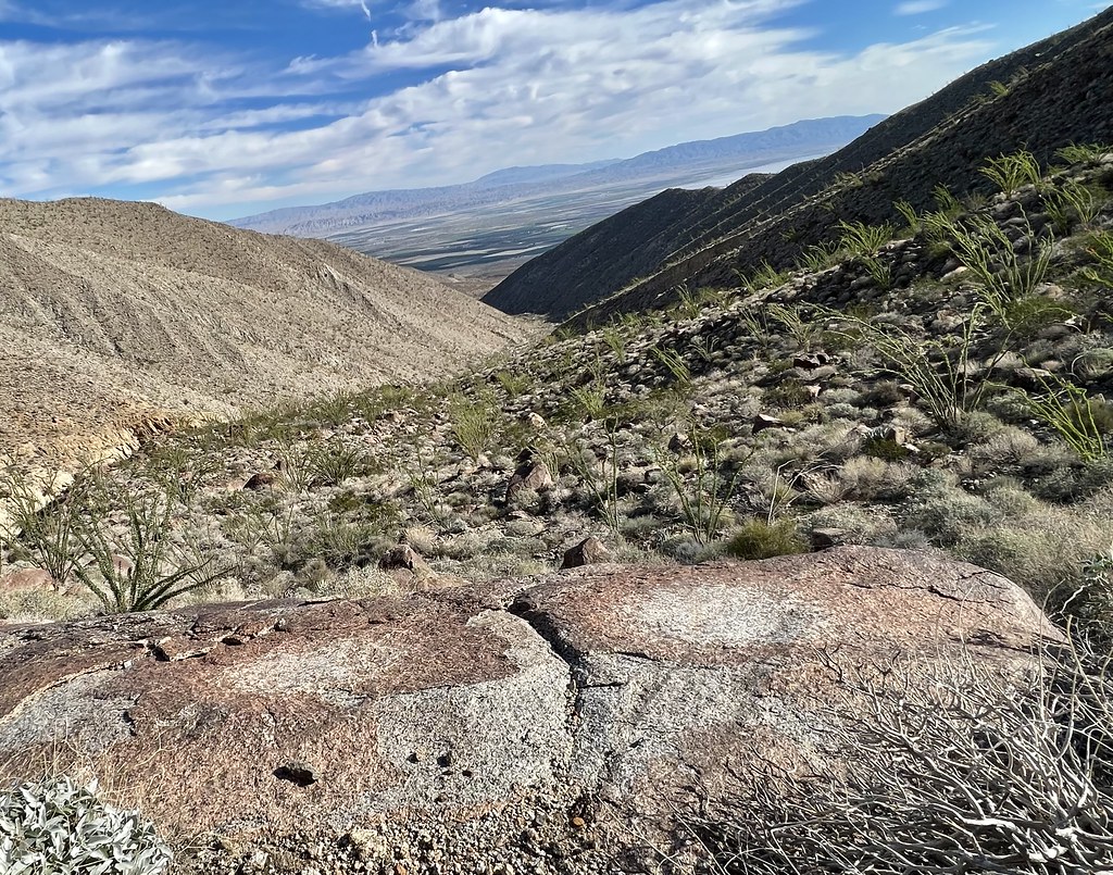
We hiked down to the Lucia ruins later that afternoon and the next morning. The ruins are on the sloping bench in the center.
 IMG_1592 by tomteske, on Flickr IMG_1592 by tomteske, on Flickr
Gary descending the trail to the ruins.
 IMG_1621 by tomteske, on Flickr IMG_1621 by tomteske, on Flickr
 IMG_1638 by tomteske, on Flickr IMG_1638 by tomteske, on Flickr
 IMG_1597 by tomteske, on Flickr IMG_1597 by tomteske, on Flickr
 IMG_1604 by tomteske, on Flickr IMG_1604 by tomteske, on Flickr
 IMG_1627 by tomteske, on Flickr IMG_1627 by tomteske, on Flickr
Couple broken metates and the base of a beat up obsidian Cottonwood point.
 IMG_1647 by tomteske, on Flickr IMG_1647 by tomteske, on Flickr
 IMG_1652 by tomteske, on Flickr IMG_1652 by tomteske, on Flickr
 IMG_1649 by tomteske, on Flickr IMG_1649 by tomteske, on Flickr
Couple morteros.
 IMG_1605 by tomteske, on Flickr IMG_1605 by tomteske, on Flickr
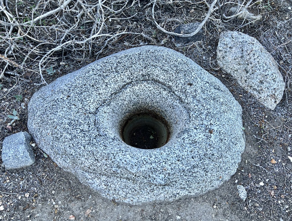 IMG_1607 by tomteske, on Flickr IMG_1607 by tomteske, on Flickr
We headed up Alamo Canyon and the trail was pretty obvious the first bit but then kind of disappeared. Fireplace maybe 100ft from the ruins.
 IMG_1669 by tomteske, on Flickr IMG_1669 by tomteske, on Flickr
 IMG_1673 by tomteske, on Flickr IMG_1673 by tomteske, on Flickr
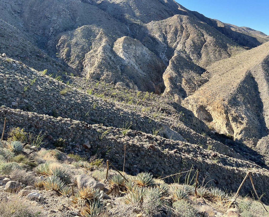
Rock walls are somewhat hard to see in this pic but suspect they are actually a corral.
 IMG_1687 by tomteske, on Flickr IMG_1687 by tomteske, on Flickr
On the way out Sunday afternoon (Randy left early due to not feeling well and Gary and Yoks spent another night) came across a couple boulders with petroglyphs. Rockhopper's videos show two more petro sites I missed.
 IMG_1728 by tomteske, on Flickr IMG_1728 by tomteske, on Flickr
 IMG_1720 by tomteske, on Flickr IMG_1720 by tomteske, on Flickr
 IMG_1723 by tomteske, on Flickr IMG_1723 by tomteske, on Flickr
Made it back to the car in the dark, about 18 miles and a nice start to the backpacking season. Thanks to Yoks, Gary and Randy for the invite. Enjoy!
 IMG_1737 by tomteske, on Flickr IMG_1737 by tomteske, on Flickr
edited by tommy750 on 11/6/2022
|
|
|
+2
link
|
|
Rocko1 Posts: 622
11/7/2022
|
Really fantastic report. I suspect the ducks are for the Villager east approach. I have always wanted to explore that side of the mountain but the parking logistics always deterred me.
|
|
|
link
|
|
tommy750 Posts: 1086
11/7/2022
|
Rocko1 wrote:
Really fantastic report. I suspect the ducks are for the Villager east approach. I have always wanted to explore that side of the mountain but the parking logistics always deterred me.
Think we discussed parking more than any other topic prior to the trip. GE has a "trailhead" icon at 80th and Fillmore but 80th has a dirt berm across it and Fillmore south of the E-W drainage channel is heavily signed no trespassing. The only other for sure not private property and not trespassing parking location for hikes to the south eg Salton Sea Petroglyph Trail/Travertine Palms would be at the west end of 86th. Certainly would like to know if anyone else is aware of other legit parking locations.
|
|
|
+1
link
|
|
Brian Posts: 253
11/7/2022
|
Great trip report. I love hearing about areas that aren't in the books. I did Martinez Canyon one time, so I know the parking challenge in that area.
|
|
|
link
|
|
tommy750 Posts: 1086
11/7/2022
|
Brian wrote:
Great trip report. I love hearing about areas that aren't in the books. I did Martinez Canyon one time, so I know the parking challenge in that area.
Definitely agree. Looks like someone spent the summer building a 300 acre golf course right near the mouth of Martinez Canyon. Curious.
 Martinez Canyon Golf Course by tomteske, on Flickr Martinez Canyon Golf Course by tomteske, on Flickr
|
|
|
link
|
|
Brian Posts: 253
11/8/2022
|
tommy750 wrote:
Brian wrote:
Great trip report. I love hearing about areas that aren't in the books. I did Martinez Canyon one time, so I know the parking challenge in that area.
Definitely agree. Looks like someone spent the summer building a 300 acre golf course right near the mouth of Martinez Canyon. Curious.
That's wild. My version of GE is still showing an agricultural field in that spot. It doesn't look like it would affect how I went in before, from 68th and Van Buren.
edited by Brian on 11/8/2022
|
|
|
link
|
|
ziphius Posts: 911
11/8/2022
|
Nice-looking trip guys.
--
http://www.coyotelearning.org
|
|
|
link
|
|
rockhopper Posts: 678
11/8/2022
|
Way to go! Glad you guys had an excellent adventure exploring the rock house canyons in the "other side" of the Santa Rosas. I am still searching for more to explore. Hard to imagine the Natives and Folks used to live back in there! Did you guys' pack in water or did you find the spring below Cris Lucia rock house? Rocko1, the "Trail to the left" is the most direct approach to Rabit peak up Barton canyon.
Can I add some pics?
Spring below Chris Lucia rock house.


Lucia rock hose from the trail with tele photo

I like this view. The Lucia rock house built on top of the Native American village here had a full view of the "Full" Lake Cahuilla.

My first thoughts that the rock walls up Alamo canyon were of an old Native American village. I called it S.R.I.R 2.0, but with minimal pot shares or grinding rocks I am thinking you are right as a possible corral.

On a side note, further up Alamo canyon there are some rock piles that look like old mining claim markers.
edited by rockhopper on 11/8/2022
|
|
|
+1
link
|
|
tommy750 Posts: 1086
11/8/2022
|
Nice find, Rockhopper. We did not find any water below the site. I came up the wash from below and climbed to the top of the white rock dry falls and did not see any water but didn't actually wade through the reeds and catclaw. Yoks crossed over to the mining adit on the other side of the stream bed and didn't see any water either. Think Yoks found some mining claims above the Alamo Canyon site.
Rockhopper, were you able to find any mining activity in either canyon? It seems someone went through a lot of trouble to build that path and rock houses and not have some sort of sizeable mining activity. Thanks for the pics!
|
|
|
+1
link
|
|
rockhopper Posts: 678
11/9/2022
|
tommy750 wrote:
Nice find, Rockhopper. We did not find any water below the site. I came up the wash from below and climbed to the top of the white rock dry falls and did not see any water but didn't actually wade through the reeds and catclaw. Yoks crossed over to the mining adit on the other side of the stream bed and didn't see any water either. Think Yoks found some mining claims above the Alamo Canyon site.
Rockhopper, were you able to find any mining activity in either canyon? It seems someone went through a lot of trouble to build that path and rock houses and not have some sort of sizeable mining activity. Thanks for the pics!
Hi Tommy750,
You were really close. Yep, I had to go up the dry waterfalls and wade thru the reeds, cat claw, and bust thru a lot of dead branches. It made it easier for the wildlife. Ha! I was thinking of the same thing regarding mining activity. I saw a lot of mining claim markers further up Alamo canyon but no mining tailings. Maybe they were searching for the "Lost Esmerald mine of the Santa Rosas" Oh my!
Here is the spring location below the Lucia rock house. It's up aways towards the lone palm.

Poking around a rock face I found this seep also.

Glad you guys had a great adventure. It was my 3rd time up the canyon before I found water.
|
|
|
+1
link
|
|
Buford Posts: 468
11/9/2022
|
Nice work. Definitely looks worthy of exploring. Lots of cool artifacts you guys found. Good to see the lone hiker still has the port and starboard tape on the trekking poles.
Always sketchy leaving a car there even for a couple hours. I only know about the two parking areas already pointed out.
--
Links to my photos: ABDSP photos, Bighorn sheep photos, ABDSP time lapse video, Wildlife photos (mainly birds)
|
|
|
+1
link
|
|
tekewin Posts: 386
11/15/2022
|
Rocko1 wrote:
Really fantastic report. I suspect the ducks are for the Villager east approach. I have always wanted to explore that side of the mountain but the parking logistics always deterred me.
Yes, that's east approach to Rabbit through Barton Canyon. The white rocks really stand out in the dark, very helpful.
Amazing trip. Had no idea so many artifacts were out there.
edited by tekewin on 11/15/2022
|
|
|
+1
link
|