Talk about a trip you took out to Anza Borrego
Trip to Harper Canyon
|
surfponto Administrator Posts: 1364
3/15/2010
|
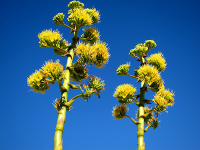
Our trip to Harper Canyon in the central part of the park was a great success. Great weather with a little bit of wind.
A lot of blooming Agave in the area and a few Mojave Yucca.
Still think we are in for a great flower season in two - three weeks time,
Trip Post
Bob
--
https://www.anzaborrego.net/


|
|
|
link
|
|
hikerdmb Posts: 423
3/15/2010
|
Bob,
Nice trip report. It must have been pretty cool being guided around by Mark Jorgenson. How far down Harper Canyon did you go before you came to the dam and the cabin? At the end of the post you said you hiked down Harper Canyon. Did you go all the way down and out or did you go back through Harper Flat and out Pinyon Wash? I have never been down into Harper Canyon. We have walked by the entrance to the canyon while in Harper Flat a couple of times but never entered it. And we have driven to the lower entrance a couple of times too. We have even discussed hiking up Harper Canyon as a way to get to Harper Flat but it so much longer and with way more elevation gain than going through Pinyon Wash, so we have always taken the easy way. Also, any word on sleeping circles? And did you check out any of the side washes in the lower part of Pinyon Wash. I am curios too if the Indian site was just to the left as you entered Harper Flat or somewhere else. I know there are lots of morteros about a half mile or to the east after you get into Harper Flat.
David
|
|
|
link
|
|
surfponto Administrator Posts: 1364
3/15/2010
|
Hi David,
Yeah he is basically a walking Encyclopaedia of the Anza Borrego desert.
He remembers giving me a warning ticket a few years back in Carrizo Gorge for parking off the trail. 
Great guy. I would definitely take another trip with him if one comes up. Apparently the ABF is trying to get him to do a trip every week.
To answer your questions.
Yes the Indian site is where you said. right to the left as you come into Harper flat.
The dam and the cabin are in two separate side canyons.
when you say you drove does that mean you came down Heart Attack Hill and the Squeeze from that side?
I should have asked him about the sleeping circles...shoot :-(
He did tell me where to find the Carrizo Gorge Pictographs.
I think they are the one's that according to him may have been "touched up" in the 1940s.
Bob
hikerdmb wrote:
Bob,
Nice trip report. It must have been pretty cool being guided around by Mark Jorgenson. How far down Harper Canyon did you go before you came to the dam and the cabin? At the end of the post you said you hiked down Harper Canyon. Did you go all the way down and out or did you go back through Harper Flat and out Pinyon Wash? I have never been down into Harper Canyon. We have walked by the entrance to the canyon while in Harper Flat a couple of times but never entered it. And we have driven to the lower entrance a couple of times too. We have even discussed hiking up Harper Canyon as a way to get to Harper Flat but it so much longer and with way more elevation gain than going through Pinyon Wash, so we have always taken the easy way. Also, any word on sleeping circles? And did you check out any of the side washes in the lower part of Pinyon Wash. I am curios too if the Indian site was just to the left as you entered Harper Flat or somewhere else. I know there are lots of morteros about a half mile or to the east after you get into Harper Flat.
David
--
https://www.anzaborrego.net/
|
|
|
link
|
|
hikerdmb Posts: 423
3/15/2010
|
Bob,
I have never been down that drop off by the squeeze. I have been to the top and I have been close to the bottom by coming in through Split Mountain/ Fish Creek, but never been all the way through. When I say we drove to the lower part of Harper Canyon...you can take a dirt road off of highway 78 that will take you to the lower (northern) mouth of Harper Canyon. Sorry I wasn't too clear on that. You can hike up (south) into Harper Flat from the end of this road but it is much longer and more elevation gain than by going through Pinyon Wash. Can you send me a google earth of the location of the cabin and dams?
I did not know about pictographs in Carrizo but I would like to. I know that in Joshua Tree there are some pictographs that were retouched for a Disney film but this is the first I have heard of this in Carrizo. I have seen the pictographs in JT and they are very fake looking.
Also I am still confused on your exit from Harper Flat. Did you go back the same way you came in? If you did go all the way through Harper Canyon I would be interested in knowing what it is like through there.
David
|
|
|
link
|
|
surfponto Administrator Posts: 1364
3/15/2010
|
Oh I see. I forgot about the Fish Creek access.
No we basically turned around and came back the way we came. (Pinyon Wash)
Harper canyon is cool. It is pretty narrow with vertical side walls.
I can send you a Google Earth link tonite
Here is a pic I found of the pictographs in Carrizo Gorge.

Like I said, I think they were touched up years ago. I think they are hard to find but I have a general idea of where thay are.
Bob
hikerdmb wrote:
Bob,
I have never been down that drop off by the squeeze. I have been to the top and I have been close to the bottom by coming in through Split Mountain/ Fish Creek, but never been all the way through. When I say we drove to the lower part of Harper Canyon...you can take a dirt road off of highway 78 that will take you to the lower (northern) mouth of Harper Canyon. Sorry I wasn't too clear on that. You can hike up (south) into Harper Flat from the end of this road but it is much longer and more elevation gain than by going through Pinyon Wash. Can you send me a google earth of the location of the cabin and dams?
I did not know about pictographs in Carrizo but I would like to. I know that in Joshua Tree there are some pictographs that were retouched for a Disney film but this is the first I have heard of this in Carrizo. I have seen the pictographs in JT and they are very fake looking.
Also I am still confused on your exit from Harper Flat. Did you go back the same way you came in? If you did go all the way through Harper Canyon I would be interested in knowing what it is like through there.
David
--
https://www.anzaborrego.net/
|
|
|
link
|
|
surfponto Administrator Posts: 1364
3/16/2010
|
Hey David,
I emailed a Google Earth Waypoint of the cabin.
Let me know if you have any trouble with it.
I forgot to ask, have you seen the dam out there?
If you have you were very close to the cabin
Bob
--
https://www.anzaborrego.net/
|
|
|
link
|