|
harmono Posts: 71
12/4/2012
|
Previously I was planning on going out to Goat Canyon Trestle via an unknown creek/wash that is north of Piedras Grandes. It's not Indian Wash. Now I'm thinking of possibly going from Indian Canyon trestle north of that, and going up that wash to a creek that goes south of Indian Hill. This creek cuts through the mountains, and takes you near "Toy Trestle", and I plan on walking on the hill that the tunnel cuts through south of it there.
Here is a Google Earth video link that explains the path in 3D.
http://youtu.be/GpeCuVnLAFg
I mapped it out on Google Maps.
https://maps.google.com/maps/ms?msid=200894553877442534046.0004cd8885173c865ca28&msa=0&ll=32.73666,-116.180871&spn=0.012238,0.013819
http://www.flickr.com/photos/89836383@N03/
edited by harmono on 12/4/2012
edited by harmono on 12/4/2012
--

IMG_1032 by harmono619, on Flickr
|
|
|
link
|
|
surfponto Administrator Posts: 1369
12/4/2012
|
I believe that is doable
You could also just take it to the toy trestle and walk up the tracks
Bob
harmono wrote:
Previously I was planning on going out to Goat Canyon Trestle via an unknown creek/wash that is north of Piedras Grandes. It's not Indian Wash. Now I'm thinking of possibly going from Indian Canyon trestle north of that, and going up that wash to a creek that goes south of Indian Hill. This creek cuts through the mountains, and takes you near "Toy Trestle", and I plan on walking on the hill that the tunnel cuts through south of it there.
I mapped it out on Google Maps.
https://maps.google.com/maps/ms?msid=200894553877442534046.0004cd8885173c865ca28&msa=0&ll=32.73666,-116.180871&spn=0.012238,0.013819
http://www.flickr.com/photos/89836383@N03/
edited by harmono on 12/4/2012
--
https://www.anzaborrego.net/


|
|
|
link
|
|
harmono Posts: 71
12/4/2012
|
surfponto wrote:
I believe that is doable
You could also just take it to the toy trestle and walk up the tracks
Bob
Yeah I'm thinking of going that way on the way back. I made a video tour of this hike on Google Maps in 3D.
http://youtu.be/GpeCuVnLAFg
--
IMG_1032 by harmono619, on Flickr
|
|
|
link
|
|
harmono Posts: 71
12/6/2012
|
Here is an update on this just in case you are following this. Let me know if you are interested in going there. I have changed the date but it's tentative, late December is all I can say.
What's really cool is this panorama photo taken by Deren, I hope he doesn't mind me posting this link.
http://www.darensefcik.com/Photography/Panoramas/16201833_YA53r#!i=1250440396&k=iM7CB&lb=1&s=A
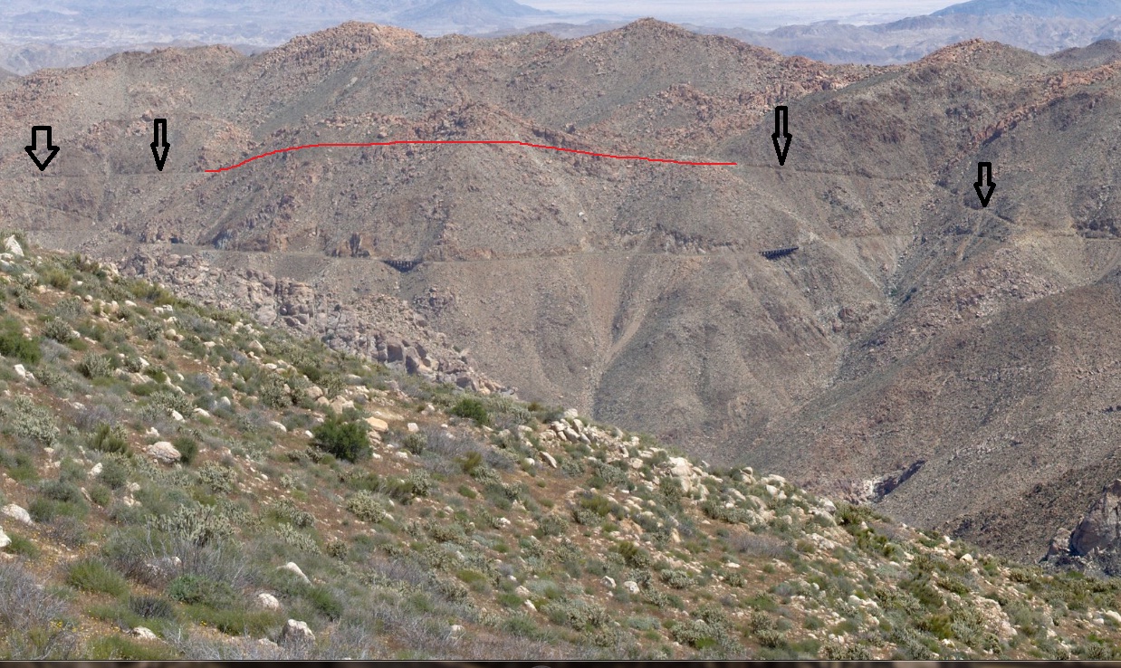
In this panorama I was able to learn things about the area that I could not through other tools. I've been looking for photos of the toy trestle. In this panorama you can see two trestles on the left part (north).
The trestle on the right I believe is called "Toy Trestle" , to the right of that is the area of interest. I was wondering what the descent would be like. What I found interesting is that I suspected that there was a road partially down the descent and I was right apparently. I can see what looks like a road cut out from the side of the hill that seems to go from the north part of the tracks behind a rocky hill, then down towards the tunnel south of the toy trestle. That was confirmation of what I had suspected. I'm not sure if I will be taking this route, but I will probably be trying to document this route for others. I have never heard anyone mention this apparent road even with the controversy surrounding the CZRY police enforcing trespassing laws. This path would reduce walking on or near the tracks to a minimum (or if you just wanted to view the area) in case people are concerned about that.
--
IMG_1032 by harmono619, on Flickr
|
|
|
link
|
|
dsefcik Administrator Posts: 2634
12/7/2012
|
Casey Van Tieghem wrote:
What I found interesting is that I suspected that there was a road partially down the descent and I was right apparently. I can see what looks like a road cut out from the side of the hill that seems to go from the north part of the tracks behind a rocky hill, then down towards the tunnel south of the toy trestle. That was confirmation of what I had suspected. I'm not sure if I will be taking this route, but I will probably be trying to document this route for others. I have never heard anyone mention this apparent road even with the controversy surrounding the CZRY police enforcing trespassing laws. This path would reduce walking on or near the tracks to a minimum (or if you just wanted to view the area) in case people are concerned about that.
There are a lot of bypass roads out there. I have always wondered about that high road above the tracks, lets us know what you find.
This is the road you are talking about right?
--
http://www.sefcik.com
http://www.darensefcik.com
http://www.carrizogorge.com
|
|
|
link
|
|
surfponto Administrator Posts: 1369
12/7/2012
|
Sorry a little off topic, but I just checked out Daren's panorama shot again.
That is an amazing photo !

Like Daren says, please report what you find Casey
Casey Van Tieghem wrote:
Here is an update on this just in case you are following this. Let me know if you are interested in going there. I have changed the date but it's tentative, late December is all I can say.
What's really cool is this panorama photo taken by Deren, I hope he doesn't mind me posting this link.
http://www.darensefcik.com/Photography/Panoramas/16201833_YA53r#!i=1250440396&k=iM7CB&lb=1&s=A
In this panorama I was able to learn things about the area that I could not through other tools. I've been looking for photos of the toy trestle. In this panorama you can see two trestles on the left part (north).
The trestle on the right I believe is called "Toy Trestle" , to the right of that is the area of interest. I was wondering what the descent would be like. What I found interesting is that I suspected that there was a road partially down the descent and I was right apparently. I can see what looks like a road cut out from the side of the hill that seems to go from the north part of the tracks behind a rocky hill, then down towards the tunnel south of the toy trestle. That was confirmation of what I had suspected. I'm not sure if I will be taking this route, but I will probably be trying to document this route for others. I have never heard anyone mention this apparent road even with the controversy surrounding the CZRY police enforcing trespassing laws. This path would reduce walking on or near the tracks to a minimum (or if you just wanted to view the area) in case people are concerned about that.
edited by surfponto on 12/7/2012
--
https://www.anzaborrego.net/
|
|
|
link
|
|
harmono Posts: 71
12/18/2012
|
There are a lot of bypass roads out there. I have always wondered about that high road above the tracks, lets us know what you find.
This is the road you are talking about right?
I'm sorry I can barely see that picture, and I could not download it.
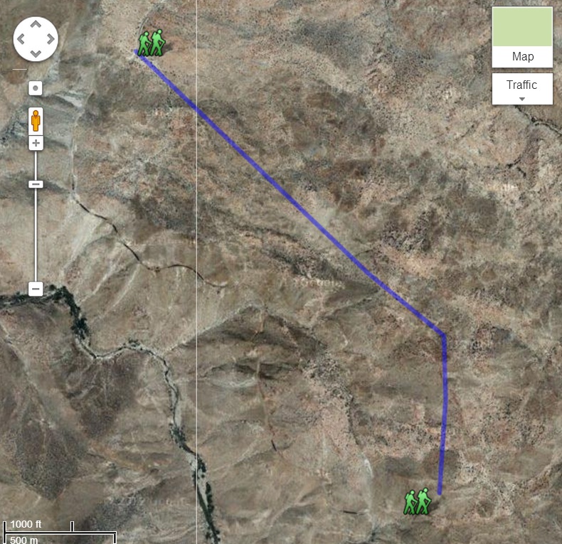
I marked the places on this map. One mark is the trailhead from the track, the other mark is what I think I saw as a cutout on the panorama.
https://maps.google.com/maps/ms?msid=200894553877442534046.0004d125b519327568522&msa=0&ll=32.757577,-116.192522&spn=0.01126,0.013819
I can only see it clearly in your panorama shot I think taken from Sacatone overlook, so it must be the same thing, however there are a couple of places, one that leads from the old ruins area (the jeep trail) and another one that is further south I think. My co-worker and I might be going to Sacatone overlook to check that out. How is the road up there? Is it possible for me to drive my Saturn at least close enough to walk half a mile to get there?

Thanks.
--
IMG_1032 by harmono619, on Flickr
|
|
|
link
|
|
harmono Posts: 71
12/18/2012
|
surfponto wrote:
Sorry a little off topic, but I just checked out Daren's panorama shot again.
That is an amazing photo !
Yes it is amazing. Imagine this. I spent hours and hours looking at Google Earth, then I see this picture and clearly before me is this road cut into the mountain.
Also if you look on the left side of Daren's photo (which I cropped above - that's not my photo. Sorry Daren for stealing your pic it's just for illustration.) you will see another road that descends down to the tracks. It seems like there is a road that goes down most of the track there. If the train becomes fully active again ,there might be a way to get to this area without walking on the tracks at all, but it's kind of rough near the Goat Canyon area. There is a road that does go over the tunnel just north of Goat Canyon though.

edited by harmono on 12/18/2012
--
IMG_1032 by harmono619, on Flickr
|
|
|
link
|
|
harmono Posts: 71
12/18/2012
|
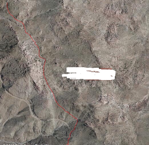
After looking at various maps and aerial photos I have found that indeed a road has been cut through most of this area. It's very clear on this aerial photo. For some reason Google Maps have airbrushed most of this from the picture or the resolution is poor. This road actually cuts out more than a quarter mile from the railroad tracks, and the steepness of the path does not look bad at all. It seems a little rocky in places, but there seems to be nice bushes or palms on part of the route. I wonder what the view is like. This is really interesting. Of course you would miss some of the trestles and tunnels, but who knows what you might find up there, it could be people haven't been up there in years.
edited by harmono on 12/18/2012
--
IMG_1032 by harmono619, on Flickr
|
|
|
link
|
|
dsefcik Administrator Posts: 2634
12/20/2012
|
I remember the last time we were out on there looking up at that road wondering what it was. You could probably drive some of the way in your Saturn to Sacatone Overlook but there are some big ruts towards the end when you get to the old mine prospect.
--
http://www.sefcik.com
http://www.darensefcik.com
http://www.carrizogorge.com
|
|
|
link
|
|
dsefcik Administrator Posts: 2634
12/21/2012
|
I looked thru some of my photos from the last helicopter trip I did out there and didn't find much but there are some cool photos from above.
This one may have something you can zoom in on and see but really...look at this thing, would you ride a train on that..???


--
http://www.sefcik.com
http://www.darensefcik.com
http://www.carrizogorge.com
|
|
|
+1
link
|
|
harmono Posts: 71
12/21/2012
|
dsefcik wrote:
I looked thru some of my photos from the last helicopter trip I did out there and didn't find much but there are some cool photos from above.
This one may have something you can zoom in on and see but really...look at this thing, would you ride a train on that..???
Wow! Those are awesome pictures. Especially the one of the Goat Canyon Trestle, one of the best shots that I have seen. It shows exactly what that area consists of.
My Dad did ride on this back in the '70's. The pictures confirm what I'm seeing in other shots. How did you get a helicopter ride there? That would be cool.
--
IMG_1032 by harmono619, on Flickr
|
|
|
link
|
|
railexplorer Posts: 71
12/25/2012
|
I'm interested in hearing what you find out. Although it looks like I might be headed out that way in the next week. I've got a young rail fan who really wants to explore the route. For a Christmas present he got a book on the SDA&E. I took a quick look through the book this morning and came across a bit of information for you. In one of the photo captions, it mentions that foot trails were built around all tunnels, to facilitate the movement of equipment and communication between the tunneling crews. Apparently they constructed the tunnels by excavating from both ends and meeting in the middle.
For those of you interested in the book, its the San Diego and Arizona Railway, the Impossible Railroad. By Reena Deutsch.
Oh and finally hello everyone I recently came across this website due to my son's interest in heading out to the Goat Canyon Trestle, this is my first post. Hopefully I'll have more to share soon.
|
|
|
link
|
|
harmono Posts: 71
12/25/2012
|
railexplorer wrote:
I'm interested in hearing what you find out. Although it looks like I might be headed out that way in the next week. I've got a young rail fan who really wants to explore the route. For a Christmas present he got a book on the SDA&E. I took a quick look through the book this morning and came across a bit of information for you. In one of the photo captions, it mentions that foot trails were built around all tunnels, to facilitate the movement of equipment and communication between the tunneling crews. Apparently they constructed the tunnels by excavating from both ends and meeting in the middle.
For those of you interested in the book, its the San Diego and Arizona Railway, the Impossible Railroad. By Reena Deutsch.
Oh and finally hello everyone I recently came across this website due to my son's interest in heading out to the Goat Canyon Trestle, this is my first post. Hopefully I'll have more to share soon.
Welcome to the forum. I'm new here too. The railfans (including myself) have invaded I guess. :-). Yeah I made it there on the 23rd, to the Goat Canyon Trestle the hidden man made gem of San Diego County. You know I never thought about reading documentation on the trails, that's right of course, anyways I found them. When I was out there I was looking for the trailhead heading south along the tracks that would circumvent about 5 trestles. I could not find it on the way down south, but I did see the beginning of the path heading north. When I headed north on the tracks I suspected that I found the trailhead, but they had put up a wall that obscured, and almost blocked the path. The path seems treacherous and extremely narrow at some points, probably due to years of rock slides. But parts of it might be usable. The total hike was about 9 miles, about 4.5 miles if you take the tracks from the end of Dos Cabesas road to the Goat Canyon Trestle.
My feet were very much hurting, I'm a heavy guy and the gravel that they put on the tracks and along the tracks made it difficult. That aside it's a fairly easy hike, it's about 2000 feet elevation so you get a little winded at times, especially ascending as you go south, but going down was a breeze. One thing unique about this trek is that there is lots of shade in the tunnels and in the rocks, and you can sit down in the tunnels. The main problem is the lack of cell phone coverage so be sure not to go alone and bring enough supplies and first aid in case something happens. It's kind of dangerous going over the trestles too.
Drop me a note, and I can help you out. I'm working on some maps of the routes, it's difficult to see the train track on Google maps. You can get out there with a decent truck with high clearance, 4WD nice to have but not essential at least on the roads we went on to get here. I posted my trip on the completed trips page, so I will try to include information on how to get there etc.
--
IMG_1032 by harmono619, on Flickr
|
|
|
link
|
|
dsefcik Administrator Posts: 2634
12/26/2012
|
You can see many of the bypasses that go around the tunnels and many of them are very eroded now.
I am curious if the book mentions anything about the camps down in the Gorge. I have explored down in there many times and there is a "road" that goes down into the Gorge just past a tunnel south of the trestle and also maybe another even further south. The latter one may have been more elaborate as there are remnants of stone walls going up the side of the canyon and down in the Gorge are several cement foundations and machine parts like large cast iron gears and such.


--
http://www.sefcik.com
http://www.darensefcik.com
http://www.carrizogorge.com
|
|
|
link
|
|
railexplorer Posts: 71
12/26/2012
|
I haven't read the book yet, but in one of the captions it mentions that work camps were built at each tunnel, except if two tunnels were close together. The camps were above or below the grade level, wherever they could flatten a spot for tents. There are a couple of pictures of one camp down in the gorge. I'll read up on the chapter about the gorge and let you know if it mentions anything.
|
|
|
+1
link
|
|
harmono Posts: 71
12/28/2012
|
railexplorer wrote:
I haven't read the book yet, but in one of the captions it mentions that work camps were built at each tunnel, except if two tunnels were close together. The camps were above or below the grade level, wherever they could flatten a spot for tents. There are a couple of pictures of one camp down in the gorge. I'll read up on the chapter about the gorge and let you know if it mentions anything.
That makes sense. I think one of the camps was hidden behind a retainer wall. Next time I go out there I want to explore the camps more, and the trails. I think I want to check out Indian Hill too. This is getting to be a habit for me, but a healthy habit I suppose. I am overcoming the obstacles of having to use a CPAP machine by buying a car adapter, so now I can camp out anywhere, or sleep in the parking lot at Golden Acorn perhaps.
I have a flat bed trailer, but I don't have a hitch installed in my latest car. I might get the hitch installed and use the flat bed as a base so I can just roll into a space and camp, that would be nice. I am starting to see that I might get addicted to this, it's so nice out there, so quiet.
--
IMG_1032 by harmono619, on Flickr
|
|
|
link
|
|
harmono Posts: 71
12/28/2012
|
I just now purchased a Kindle book about the Impossible Railroad. I two books to read now. One written by Neal Peart about his travels via motorcycle around the world, and this book.
--
IMG_1032 by harmono619, on Flickr
|
|
|
link
|