|
dsefcik Administrator Posts: 2634
9/27/2010
|
I know Death Valley has a lot of old mining cabins to explore and even stay the night in, I was wondering if there are any cabins in Anza Borrego?
--
http://www.sefcik.com
http://www.darensefcik.com
http://www.carrizogorge.com
|
|
|
link
|
|
hikerdmb Posts: 423
9/27/2010
|
There are a few places I have been to through the years but I wouldn't say any of them are "cabins" like in DV. I have been to the rockhouse in Rockhouse Canyon between Bow Willow and Carrizo Gorge but it is more like a shack built into the rocks. We camped right outside that one one very cold night then hiked over a pass on an old Indian trail into Bow Willow Canyon to make a loop back to the truck the next day. I have also spent the night at the rock houses up Rockhouse Canyon by Clark Dry Lake. I think there are three old rock houses there but nothing much left but short rock walls. About 25 years ago we stumbled across some very old remains of some sort of cabin in some small dunes on the eastern edge of Clark Dry Lake. Also there is the old stage station out in the eastern part of Carrizo Creek. I think I read somewhere that someone lived there in the 60's or 70's but it was in very bad condition last time I was there. I know Bob went to the old place near Harper Flat last year and had some pictures of it in previous post on here. I have not been to that one before although I have backpacked into Harper Flat 10+ times over the years. I marked the location of that cabin on my map to go see next time. The only pics I have of the rock houses I have been to were taken before digital so I don't have any on my computer or I would share. If I have some time I will look in my old photos and see if I can get a couple to scan and post.
|
|
|
link
|
|
hikerdmb Posts: 423
9/27/2010
|
I found a couple of pics of the rock house ruins in Rockhouse Canyon in the northern part of the park. Also I remembered one more cabin. At the northern reaches of Coyote Canyon, the Bailey Cabin. All the times I have been by there it has been locked up and I don't think you can even get there without hiking since they closed the upper part of that canyon. But not absolutely sure about that.
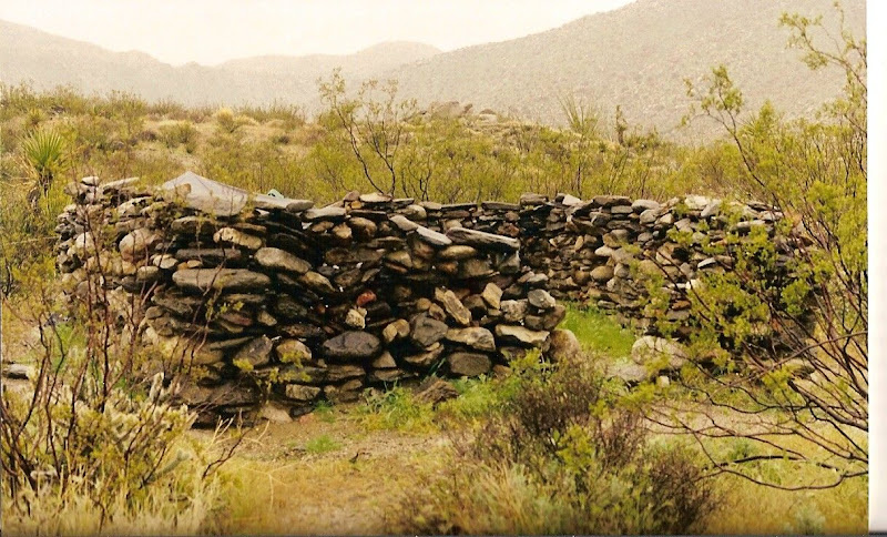
Here is a pic of one of the ruins in Rockhouse Canyon. It was a fairly large "cabin" when it was built but now as you can see, just walls and the place where the door once was located. The others looked pretty much the same as this one.
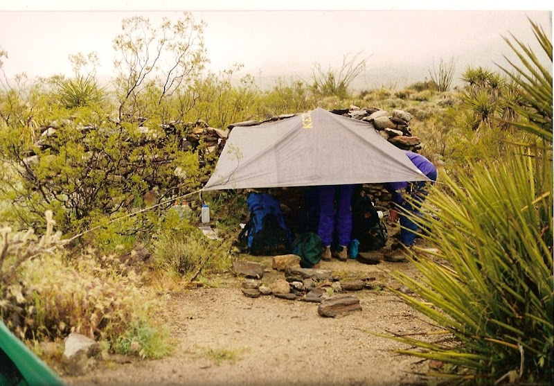
And here is my camp next to the ruin. I used the tarp on this trip because it rained so much. I set up with the rock house wall to block the wind and rain from the north. The snow level on the Santa Rosa Mountains was only about 500' above our camp. There was water running down the canyon as we hiked back out to the truck. That was a very wet trip.
Didn't find any of the other pics.
|
|
|
link
|
|
dsefcik Administrator Posts: 2634
9/27/2010
|
David, thanks for the pics and info, I appreciate you taking time to post all of that. I was actually thinking of hiking out to the rockhouse ruins this weekend or the next. I also saw the Baily cabin mentioned in my AB book but it did not say much about it. I guess ABDSP does not really have much for mining cabins like DV.
Do you know how bad the road is past the Alcoholic Pass trial going up to rockhouse canyon? General consensus from books I have are that after 8-9 miles it may not be drivable. I have a big diesel 4wd truck but deep,deep sand may not be it's best friend. If not drivable than that adds another 4 miles each way up rockhouse canyon which is significant.
thanks!
--
http://www.sefcik.com
http://www.darensefcik.com
http://www.carrizogorge.com
|
|
|
link
|
|
hikerdmb Posts: 423
9/28/2010
|
No problem, glad to help. As far as the road up Coyote Canyon...the road all the way to the last water crossing is not bad at all but the bypass they made 15 or so years ago around the willows section is very rough and has one fairly sharp corner with a huge boulder on the right. I have seen full size trucks up there but I wouldn't take my Dodge quad cab. I did have a Dodge before that had the back seat without doors and I took it up there. A couple years ago a saw a nice lifted Land Cruiser high center and lose a lot of fluids about half way up the bypass. The road is not as rough as it was when they first built it but it still is a pretty steep, long, rocky, 4 low section. Once to the top of the bypass it is very easy all around Collins Valley. It is a fun road in the jeep. I always see lots of Boy Scouts hiking up that way almost everytime I go up there.
David
|
|
|
link
|
|
hikerdmb Posts: 423
9/28/2010
|
Sorry about that previous response but I was thinking I read you were going to Bailey Cabin since Alcoholic Pass goes from Coyote Canyon too. But the road to Rockhouse Canyon is different. It is not too bad until you get to the junction where Rockhouse goes to the right and I think it is Butler Canyon to the left. From that point on it is very rocky and slow going but no big hills or real narrow parts to get through. Lots of small round rocks to crawl over but nothing big. Your truck should make it up. The road actually ends about 50 yards or so from Hidden Spring (I think that is the name). I have not been up that far in a few years but I just remember it being slow and rockyn the last 3 or 4 miles but not dangerous. Hope this helps.
David
|
|
|
link
|
|
dsefcik Administrator Posts: 2634
9/28/2010
|
hikerdmb wrote:
Sorry about that previous response but I was thinking I read you were going to Bailey Cabin since Alcoholic Pass goes from Coyote Canyon too. But the road to Rockhouse Canyon is different. It is not too bad until you get to the junction where Rockhouse goes to the right and I think it is Butler Canyon to the left. From that point on it is very rocky and slow going but no big hills or real narrow parts to get through. Lots of small round rocks to crawl over but nothing big. Your truck should make it up. The road actually ends about 50 yards or so from Hidden Spring (I think that is the name). I have not been up that far in a few years but I just remember it being slow and rockyn the last 3 or 4 miles but not dangerous. Hope this helps.
David
Yes, this is exactly where I was referring to...thanks! I had read it had very deep sand after about 9 miles. I think I can deal with rocks, especially if it will save 8 miles of hiking.
--
http://www.sefcik.com
http://www.darensefcik.com
http://www.carrizogorge.com
|
|
|
link
|
|
surfponto Administrator Posts: 1369
10/7/2010
|
Hey Daren,
Harper Cabin is pretty cool. Just walls left but cool nonetheless.
There is also the remains of an old dam nearby that is pretty impressive when you consider the Harper brother's had to haul all the cement out there.
If I remember correctly is was around a 45 minute hike from the trailhead at Pinyon Wash.
Beautiful area of ADSP.
Trip Post
Bob
dsefcik wrote:
I know Death Valley has a lot of old mining cabins to explore and even stay the night in, I was wondering if there are any cabins in Anza Borrego?
<em>edited by surfponto on 12/16/2010</em>
--
https://www.anzaborrego.net/


|
|
|
link
|
|
6kmclimber Posts: 13
12/16/2010
|
Hello all,
Just found this fourm and decided to "jump aboard"
Here' a pic of Gilberts first cabin at Clark well on my last trip 10-8-2010
[IMG]http://i67.photobucket.com/albums/h294/metalmeister/Camping/14ClarkLakeBed095.jpg[/IMG]
Easterly "well"on USGS Clark Lake,Calif. Is this the 1904 well written about?
[IMG]http://i67.photobucket.com/albums/h294/metalmeister/Camping/zClarkLakeBed099.jpg[/IMG]
edited by 6kmclimber on 12/16/2010
<em>edited by 6kmclimber on 12/17/2010</em>
|
|
|
link
|
|
surfponto Administrator Posts: 1369
12/16/2010
|
Welcome aboard.
Nice find!
Do you know the history of this one?
Bob
--
https://www.anzaborrego.net/
|
|
|
link
|
|
6kmclimber Posts: 13
12/16/2010
|
Thanks Bob,
Still trying to figure that one out.
I am pretty sure "Gilbert" came after the 40+ years the Clark brothers
cattle ranched the valley(s) in the early 1900's.
Here is a clue I found at his "newer homestead to the N/W of the sand dune buried
homestead. Water was in the well at about 30-50 ft.
Others please chime to add or correct.
[IMG]http://i67.photobucket.com/albums/h294/metalmeister/Camping/zClarkLakeBed129.jpg[/IMG]
<em>edited by 6kmclimber on 12/16/2010</em>
|
|
|
link
|
|
hikerdmb Posts: 423
12/16/2010
|
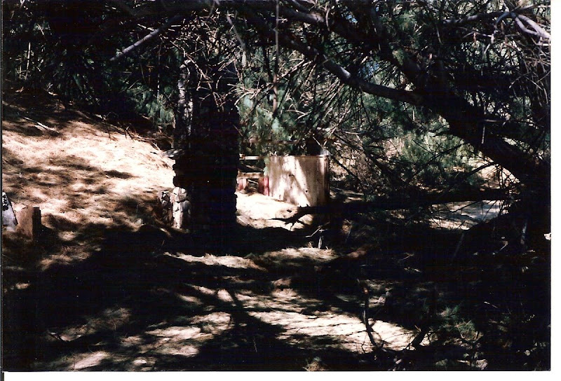
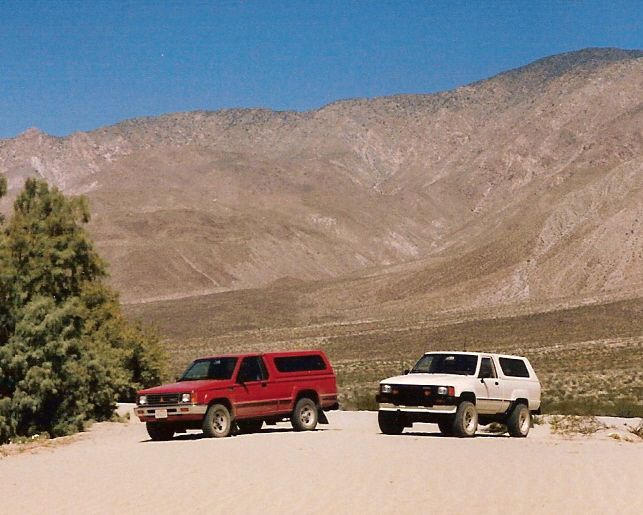
I will also add a welcome to the forum to 6kmclimber. I think the ruins you posted are the same that I mentioned in my post on this topic from 9/27/10. I see your bike in your pic. When I first went there we kind of just stumbled across it by accident. Back in 1987 we could drive right out to those small dunes. Here are a couple of pics from back then. The first is looking into the trees and you can see what I think is the same chimney remains. The second pic is my old red Mitsubishi truck and my buddy's first Toyota truck sitting on the dunes near the old cabin.
David
|
|
|
link
|
|
dsefcik Administrator Posts: 2634
12/16/2010
|
Welcome! I have never been there but the Lindsay book mentions something about old cabin ruins near Clark Dry lake, I am guessing that is what you have the pictures from?
--
http://www.sefcik.com
http://www.darensefcik.com
http://www.carrizogorge.com
|
|
|
link
|
|
6kmclimber Posts: 13
12/16/2010
|
Yes, Thats the same place you mentioned on your previous post.
Sorry forgot to mention that. I have some other photos I will post
of that trip also. Many pics of mine are also of the pre-digital age as hikerdmb
mentioned.
Thanks all for the warm welcome!
|
|
|
link
|
|
6kmclimber Posts: 13
12/17/2010
|
Again, Thanks for the warm welcome! I dug through some old photos and came up with a few "ol cabins" and rockhouses.
I took digital photos of the album photos. Reminder to self, scan all my slides and negatives. Add to bucket list
From 12-8-2010 trip. Gilberts newer homestead. As said on previous post, well had water at about 40 ft based on rock drop.
[IMG]http://i67.photobucket.com/albums/h294/metalmeister/ABDSP/CopyofClarkLakeBed119.jpg[/IMG]
[IMG]http://i67.photobucket.com/albums/h294/metalmeister/ABDSP/CopyofClarkLakeBed118.jpg[/IMG]
Following are the digital pictures of 35mm pictures.
From Jan 1993 trip into Rockhouse valley. Lower rockhouse at valley entrance ( same one as hikerdmb photos) complete with bones.
[IMG]http://i67.photobucket.com/albums/h294/metalmeister/ABDSP/CopyofSantaRosaIndianRuins1-23-1993017.jpg[/IMG]
Same trip. Upper Rockhouse valley Indian ruins. Spring and creeklets flowing. This is where we "tanked up"
[IMG]http://i67.photobucket.com/albums/h294/metalmeister/ABDSP/CopyofSantaRosaIndianRuins1-23-1993002.jpg[/IMG]
From March 1993 trip. Over the hill and outside ABDSP a bit in Martinez canyon. This is Jack Millers "upper"cabin built around 1925. The lower cabin washed out during an earlier flood. We could still see remnents of the lower cabin but no pics argggrrrr! Have to go back! When we went, the canyon was flooded and were forced to hike upstream in the icewater at the narrows.
[IMG]http://i67.photobucket.com/albums/h294/metalmeister/ABDSP/CopyofPCTrockhouse3-13-1993001.jpg[/IMG]
From Feb 1993 trip. Again a bit outside ABDSP to the north. You can see El Toro peak to the south. Cheers
[IMG]http://i67.photobucket.com/albums/h294/metalmeister/ABDSP/CopyofPCTrockhouse2-6-1993007.jpg[/IMG]
edited by 6kmclimber on 12/17/2010
<em>edited by 6kmclimber on 12/17/2010</em>
|
|
|
link
|
|
hikerdmb Posts: 423
12/17/2010
|
Those are some nice places. I am going to have to try to get to a couple of those. Thanks for the pics.
|
|
|
link
|
|
dsefcik Administrator Posts: 2634
12/17/2010
|
I am trying to visualize where this is, if Toro Peak is south than you are north of it..which puts you much more than "a bit" outside of ABDSP, that would put you way into the Santa Rosa Mtns or near Pine Mtn. Or is that more south'ish and you are still in Martinez Cyn somewhere?
Great pics, thanks for sharing!
6kmclimber wrote:
From Feb 1993 trip. Again a bit outside ABDSP to the north. You can see El Toro peak to the south. Cheers
[IMG]http://i67.photobucket.com/albums/h294/metalmeister/ABDSP/CopyofPCTrockhouse2-6-1993007.jpg[/IMG]
--
http://www.sefcik.com
http://www.darensefcik.com
http://www.carrizogorge.com
|
|
|
link
|
|
surfponto Administrator Posts: 1369
12/18/2010
|
Great old pictures.
I am guessing that cabin is no longer standing?
Bob
--
https://www.anzaborrego.net/
|
|
|
link
|
|
6kmclimber Posts: 13
12/18/2010
|
dsefcik
You are correct. The last rockhouse/cabin is about 12 miles to the north of Torro peak and is a more than a bit out side of ABDSP. Administrator, don't ban me yet I just joined
Anyway I just thought is was a neat ol' homestead. Inside was completely full of cobwebs and provisions looked like from the 50's. There was a nice seasonal creek real closeby and
grid holes, pot sherds everywhere. Probably a native spring/fall camp on thier way up and down the mountians. I will try to future keep posts closer to ABDSP. Even our beloved Rabbit peak, Santa Rosa indian Ruins, Cactus spring, etc...... are outside ABDSP and in the "Other "county
Surfponto
I don't know. Well, that it. I need to go back and check! I was amazed that Jack Millers rockhouse from the 1920's was still standing when I was last there in the 1990's what with all the faulting and earthquakes nearby. I intend to return in 2011. The other complete rockhouse, I have no history or no Idea how old but was soildly cemented with a concrete floor. The poor mule had to lug 90# sacks of cement back in there back then. True grit!
btw I used to surf ponto tons back in the 1980's . I still surf but not nearly as much. Only like 1/100th as much.
edited by 6kmclimber on 12/18/2010
<em>edited by 6kmclimber on 12/18/2010</em>
|
|
|
link
|
|
dsefcik Administrator Posts: 2634
12/19/2010
|
OK, that makes sense then. I say close enough, no worries..glad you took time to post them, I would like to know more about Martinez canyon. Did you enter/exit via ABDSP or from the east somewhere?
6kmclimber wrote:
dsefcik
You are correct. The last rockhouse/cabin is about 12 miles to the north of Torro peak and is a more than a bit out side of ABDSP. Administrator, don't ban me yet I just joined
Anyway I just thought is was a neat ol' homestead. Inside was completely full of cobwebs and provisions looked like from the 50's. There was a nice seasonal creek real closeby and
grid holes, pot sherds everywhere. Probably a native spring/fall camp on thier way up and down the mountians. I will try to future keep posts closer to ABDSP. Even our beloved Rabbit peak, Santa Rosa indian Ruins, Cactus spring, etc...... are outside ABDSP and in the "Other "county
--
http://www.sefcik.com
http://www.darensefcik.com
http://www.carrizogorge.com
|
|
|
link
|
|
surfponto Administrator Posts: 1369
12/19/2010
|
Thanks again for sharing those. Would like to spend sometime exploring that area.
I don't mind about the area being outside of ABDSP. That is why I changed the BLOG title to "and the surrounding San Diego backcountry". Oh wait I guess that is considered Riverside County.
With regards to Ponto, I live on the CBad border in Leucadia so I can walk over there.
Gotten a bit crowded over the years so I tend to just surf out front here. I remember surfing there way before the jetty also. Still a good wave
--
https://www.anzaborrego.net/
|
|
|
link
|
|
6kmclimber Posts: 13
12/19/2010
|
dsefcik wrote:
OK, that makes sense then. I say close enough, no worries..glad you took time to post them, I would like to know more about Martinez canyon. Did you enter/exit via ABDSP or from the east somewhere?
Hi dsefcik,
I have always entered and exited Martinez and Auga Alta Canyon from the east side. I have been thinking of doing a trip from Rockhouse valley following the native american
trail up and over into Martinez canyon. It would be a "tough" hike as the trail is seldom used. Anyway from the east, there are multiple points of access but they seem to change
every year with new locked gates and "rearranged" washes. I have always managed to get through even though meant hiking more miles. I seem to have spent the last couple seasons always heading up Auga Alta canyon but I would like to return to Jack Millers cabin
edited by 6kmclimber on 12/19/2010
edited by 6kmclimber on 12/19/2010
edited by 6kmclimber on 12/19/2010
<em>edited by 6kmclimber on 12/19/2010</em>
|
|
|
link
|
|
6kmclimber Posts: 13
12/19/2010
|
surfponto wrote:
Thanks again for sharing those. Would like to spend sometime exploring that area.
I don't mind about the area being outside of ABDSP. That is why I changed the BLOG title to "and the surrounding San Diego backcountry". Oh wait I guess that is considered Riverside County.
With regards to Ponto, I live on the CBad border in Leucadia so I can walk over there.
Gotten a bit crowded over the years so I tend to just surf out front here. I remember surfing there way before the jetty also. Still a good wave
Surfponto,
Seems like we all pay no attention to county lines
Ah yes, before the jetty. Brings back memories. Cheers.
Oh, btw I hail from across the lagoon in the republic of Karlsbad
<em>edited by 6kmclimber on 12/19/2010</em>
|
|
|
link
|
|
surfponto Administrator Posts: 1369
12/21/2010
|
True.
Pretty cool that Anza Borrego covers three counties.
I am always amazed when I look at a map and realize how big it is.
For years we only camped and hiked south of Agua Caliente.
Trying to slowly change that.
6kmclimber wrote:
Surfponto,
Seems like we all pay no attention to county lines
Ah yes, before the jetty. Brings back memories. Cheers.
Oh, btw I hail from across the lagoon in the republic of Karlsbad
edited by 6kmclimber on 12/19/2010
--
https://www.anzaborrego.net/
|
|
|
link
|
|
dsefcik Administrator Posts: 2634
10/29/2012
|
This is a great thread and now I have more plans of where to go back and visit. On my Rockhouse Canyon trip recently, Gary pointed out the indian trail that goes near the Miller cabin.
6kmclimber wrote:
This is Jack Millers "upper"cabin built around 1925. The lower cabin washed out during an earlier flood. We could still see remnents of the lower cabin but no pics argggrrrr! Have to go back! When we went, the canyon was flooded and were forced to hike upstream in the icewater at the narrows.
[IMG]http://i67.photobucket.com/albums/h294/metalmeister/ABDSP/CopyofPCTrockhouse3-13-1993001.jpg[/IMG]
--
http://www.sefcik.com
http://www.darensefcik.com
http://www.carrizogorge.com
|
|
|
link
|
|
AdventureGraham Posts: 170
10/30/2012
|
This thread is awesome!
Here's an article I found about hiking Martinez Canyon. http://www.palmspringslife.com/Palm-Springs-Life/January-2011/The-Most-Brutal-Hike/
|
|
|
link
|
|
dsefcik Administrator Posts: 2634
10/30/2012
|
I read that before, interesting and somewhat comical....
BorregoWrangler wrote:
This thread is awesome!
Here's an article I found about hiking Martinez Canyon. http://www.palmspringslife.com/Palm-Springs-Life/January-2011/The-Most-Brutal-Hike/
--
http://www.sefcik.com
http://www.darensefcik.com
http://www.carrizogorge.com
|
|
|
link
|