|
DRT Lakeside Posts: 62
12/17/2012
|
Stayed at Agua Caliente Friday and Saturday night. On Saturday we went out Carrizo Canyon and up the East Fork hoping to see the palms as explained in the Lindsay book "The Anza Borrego Desert Region". Did not make it all the way to the palms, but now that I check the maps/google earth, we were not far off. We were wondering if we took a wrong turn. Book says about 2 miles, and we hiked for 2 hours before we turned around and figured we should have seen them by now. Finally started a GPS track on my phone once we headed back and it indicated 2.2 miles. We were pretty close. bummer.
On Sunday we headed out June Wash and decided to hike up and get a look at Sandstone Canyon as indicated in the same book. I had hoped to stumble upon the Diablo BM, as the book referenced it, but it was not on the map I had. (Anza Borrego Desert Region-Recreation Map). Anyway, hiked up the ridges, faint trail with a few ducks made it easy, but I think I passed the Diablo BM, but had a great view of Sandstone Canyon and surrounding area. Using a GPS app on my phone I created a waypoint and then plotted it on Caltopo. (pic below-I'm the blue dot)

We had a great time, weather was awesome, I just need to work on my GPS skills before I head out. 
Also checked out Bow Willow and a few other places we had driven by but never checked out.
Pics and captions are here. Roughly in sequence
https://plus.google.com/photos/111004590236580500907/albums/5822934782766175985?authkey=CMDNuYXUspuabw
Dave
|
|
|
link
|
|
ziphius Posts: 911
12/17/2012
|
Nice trip Dave. Enjoyed the rainbows and washes. You were SOOOO close to Diablo.
--
http://www.coyotelearning.org
|
|
|
link
|
|
surfponto Administrator Posts: 1369
12/17/2012
|
Looks like a great weekend!
Rainbows shots are great.
I remember when we did that hike up Carrizo Gorge East Fork, we kept thinking we had missed the palms also.
It is a ways up there..

DRT Lakeside wrote:
Stayed at Agua Caliente Friday and Saturday night. On Saturday we went out Carrizo Canyon and up the East Fork hoping to see the palms as explained in the Lindsay book "The Anza Borrego Desert Region". Did not make it all the way to the palms, but now that I check the maps/google earth, we were not far off. We were wondering if we took a wrong turn. Book says about 2 miles, and we hiked for 2 hours before we turned around and figured we should have seen them by now. Finally started a GPS track on my phone once we headed back and it indicated 2.2 miles. We were pretty close. bummer.
On Sunday we headed out June Wash and decided to hike up and get a look at Sandstone Canyon as indicated in the same book. I had hoped to stumble upon the Diablo BM, as the book referenced it, but it was not on the map I had. (Anza Borrego Desert Region-Recreation Map). Anyway, hiked up the ridges, faint trail with a few ducks made it easy, but I think I passed the Diablo BM, but had a great view of Sandstone Canyon and surrounding area. Using a GPS app on my phone I created a waypoint and then plotted it on Caltopo. (pic below-I'm the blue dot)
We had a great time, weather was awesome, I just need to work on my GPS skills before I head out.
Also checked out Bow Willow and a few other places we had driven by but never checked out.
Pics and captions are here. Roughly in sequence
https://plus.google.com/photos/111004590236580500907/albums/5822934782766175985?authkey=CMDNuYXUspuabw
Dave
--
https://www.anzaborrego.net/


|
|
|
link
|
|
AdventureGraham Posts: 170
12/17/2012
|
Looks like a fun trip. Nice photos!
|
|
|
link
|
|
tommy750 Posts: 1086
12/17/2012
|
DRT Lakeside wrote:
Stayed at Agua Caliente Friday and Saturday night. On Saturday we went out Carrizo Canyon and up the East Fork hoping to see the palms as explained in the Lindsay book "The Anza Borrego Desert Region". Did not make it all the way to the palms, but now that I check the maps/google earth, we were not far off. We were wondering if we took a wrong turn. Book says about 2 miles, and we hiked for 2 hours before we turned around and figured we should have seen them by now. Finally started a GPS track on my phone once we headed back and it indicated 2.2 miles. We were pretty close. bummer.
Dave
It's closer to 4 miles each way. The topo map's northern "Carrizo Palms" doesn't exist, only the two southern "Carrizo Palms." Still worth the hike. Tom
|
|
|
link
|
|
DRT Lakeside Posts: 62
12/17/2012
|
Thanks. Good to get a better idea of the true distance. Based on the # of footprints, it seems a pretty active route for illegal entry, but we did not see much evidence other than footprints. Only one sweatshirt and nothing else.
I think next time I might try to go the opposite way. Maybe from Indian Hill area down the canyon and out to S-2, will give me a chance to see some new stuff. I've been to Indian Hill, but not to the other stuff around there. I'll leave the dog this time and bring my brother instead.
Thinking about ways to get out again during winter break.
|
|
|
link
|
|
dsefcik Administrator Posts: 2634
12/17/2012
|
Nice TR...yeah, soooo close to Diablo...if you go back when you get up on the saddle go south'ish towards the volcanic rocks and you will hit the BM and register.
Check out this virtual tour and you will probably see where you were standing:
https://sites.google.com/a/sefcik.com/virtual-tours/diablo-bm
--
http://www.sefcik.com
http://www.darensefcik.com
http://www.carrizogorge.com
|
|
|
link
|
|
DRT Lakeside Posts: 62
12/18/2012
|
Thanks for the virtual tour. That pretty much nails it and shows a great view of where I was standing. In my fever to get to the edge and check it out, I must have kept the BM off to my right and did not really backtrack. Should have snooped around, but only stayed there for a few minutes as the wife and dog were waiting.
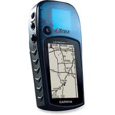
On the plus side, I was able to find my old GPS Unit (never used it much and had it in a box in the garage as I thought it had stopped working-turns out the "new" batteries I kept putting in were not new) Anyway it took a while to find satellites once powered up, but it works fine now. I will be studying up ahead of our next trip
It is not the latest but should work fine for me once I get the hang of it.
Thanks again
|
|
|
link
|
|
ziphius Posts: 911
12/18/2012
|
DRT Lakeside wrote:
On the plus side, I was able to find my old GPS Unit (never used it much and had it in a box in the garage as I thought it had stopped working-turns out the "new" batteries I kept putting in were not new) Anyway it took a while to find satellites once powered up, but it works fine now. I will be studying up ahead of our next trip
It is not the latest but should work fine for me once I get the hang of it.
Thanks again
I've had enough issues with batteries where I'm always prepared to navigate "old-school":

edited by ziphius on 12/18/2012
--
http://www.coyotelearning.org
|
|
|
link
|
|
rockhopper Posts: 678
12/18/2012
|
I still use my old USGS paper maps , sun, moon, stars and compass too
|
|
|
link
|
|
DRT Lakeside Posts: 62
12/18/2012
|
I always take a compass and map of the area with me, and can usually get by ok on our short trips, but as with most things, I wish I had more practice and a deeper working knowledge.
When my kid was in middle school we took part in the Science Olympiad. One of his events in 6th grade was called "Road Scholar" and was related to maps and navigation-mostly topo. The test was written in story form and was really fun. I figured it would be very basic, but they had to learn quite a bit and then apply it (all the symbols, tick marks, profiling, declination, bearing, azimuth, etc). My wife practiced and practiced with him; she was way more into than he was He was more into the trebuchet event.
Here is a link to some practice test and basic info r.e. the event. Just for fun....
Description and Basics:
http://scioly.org/wiki/index.php/Road_Scholar#The_Basics
Practice test:
(You would get the maps at the event)
http://scioly.org/wiki/images/8/8a/2007_Regional_Road_Scholar_Story_Exam_Rev_NC.pdf
|
|
|
link
|
|
hikerdmb Posts: 423
12/18/2012
|
I always carry a paper map and compass. That is how I learned to navigate so many years ago. I also carry my iPhone linked to my inReach which has turned my phone into a nice GPS and satellite communicator. My wife feels much better about me going solo now. However I still use the map way more than the GPS and I think I always will. But I have to say when in doubt of the map the GPS helps.
David
|
|
|
link
|
|
ziphius Posts: 911
12/19/2012
|
It is a fun, or a game-within-a-game activity to ignore your GPS for awhile, figure out where you are via map and compass, and THEN see how much difference (if any) there is between where you really are and where you think you are.
--
http://www.coyotelearning.org
|
|
|
link
|
|
tommy750 Posts: 1086
12/19/2012
|
hikerdmb wrote:
I always carry a paper map and compass. That is how I learned to navigate so many years ago. I also carry my iPhone linked to my inReach which has turned my phone into a nice GPS and satellite communicator. My wife feels much better about me going solo now. However I still use the map way more than the GPS and I think I always will. But I have to say when in doubt of the map the GPS helps.
David
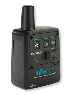
InReach by tomteske, on Flickr
David, was curious how you like your inReach. Just saw one in REI the other day and had no idea it was on the market. Have been packing an Iridium 9555 for the last few years and have zero problems paying the monthly bill to always be able to "make that one call." Can you explain how your unit works with your phone, how easy it is to send texts and about what the monthly bill is? Sat phone is nice but kinda pricey and a bit overkill. Your unit sounds like the perfect compromise. Thanks! Tom
|
|
|
link
|
|
hikerdmb Posts: 423
12/19/2012
|
Tom,
That is my unit. I got it last spring from REI and used it on 3 backpacking trips to the Sierra this summer. Also used it on a 2 week trip to Colorado and every trip to the desert this fall. With inReach I was never out of contact with wife and kids. It connects to my iPhone4 (can sync with Android phones and they also make a unit that will link with a GPS). It tracks my path wherever I am, on a trail or in the truck or jeep. It is very easy to use. I can send e-mails and text messages to anyone in the world. I can also pre-set 3 messages and send those without being connected to the iPhone. It has turned my iPhone into a GPS with the map package that comes with it. I download the area where I will be (So Cal is one map for all the topo maps of the whole area). Since I put my phone in airplane mode when in the backcountry it does NOT eat through the phone battery. Basically it is blue tooth connected to the inReach and the inReach is using the Iridium Satellites to send and receive e-mails and SMS text messages. I have had a couple of issues with it not staying synced to the iPhone but it is easy to re-sync. They have different packages from $10/month up. I have the $25/month that lets me have 40 text/SMS messages a month and unlimited pre-set messages. With the inReach I can also give a link to my wife and buddies and they can follow my track on topo, satellite, or road maps on their computers while I am out. Basically they can see where I am on Google Earth. It updates every 10 to 60 minutes depending on how I set it up. Makes them jealous but that is okay. With my plan I also get unlimited tracks that I can share and I can see my trip when I return. When I got my inReach I got it for about half price with a sale and rebate. If you go solo a lot it is a good thing to have.
|
|
|
link
|
|
dsefcik Administrator Posts: 2634
12/20/2012
|
I usually just use my GPS for "note taking" and keeping track of routes for later study. Maps are good for visually verifying where you want go. My phone with the Backcountry Navigator makes a better map than my expensive GPS with the puny screen but I don't think the phone is as accurate for field marking. The newer larger screen GPS units look good and now they have touch screens, they really need longer battery life though.
Anybody used a solar powered charger with genuine success? Something they would recommend?
--
http://www.sefcik.com
http://www.darensefcik.com
http://www.carrizogorge.com
|
|
|
link
|
|
tommy750 Posts: 1086
12/20/2012
|
hikerdmb wrote:
Tom,
That is my unit. I got it last spring from REI and used it on 3 backpacking trips to the Sierra this summer. Also used it on a 2 week trip to Colorado and every trip to the desert this fall. With inReach I was never out of contact with wife and kids. It connects to my iPhone4 (can sync with Android phones and they also make a unit that will link with a GPS). It tracks my path wherever I am, on a trail or in the truck or jeep. It is very easy to use. I can send e-mails and text messages to anyone in the world. I can also pre-set 3 messages and send those without being connected to the iPhone. It has turned my iPhone into a GPS with the map package that comes with it. I download the area where I will be (So Cal is one map for all the topo maps of the whole area). Since I put my phone in airplane mode when in the backcountry it does NOT eat through the phone battery. Basically it is blue tooth connected to the inReach and the inReach is using the Iridium Satellites to send and receive e-mails and SMS text messages. I have had a couple of issues with it not staying synced to the iPhone but it is easy to re-sync. They have different packages from $10/month up. I have the $25/month that lets me have 40 text/SMS messages a month and unlimited pre-set messages. With the inReach I can also give a link to my wife and buddies and they can follow my track on topo, satellite, or road maps on their computers while I am out. Basically they can see where I am on Google Earth. It updates every 10 to 60 minutes depending on how I set it up. Makes them jealous but that is okay. With my plan I also get unlimited tracks that I can share and I can see my trip when I return. When I got my inReach I got it for about half price with a sale and rebate. If you go solo a lot it is a good thing to have.
Thanks for the info. Sounds like a great setup. The live feed of your tracks is a great idea I wish I had. Tom
|
|
|
link
|
|
anutami Posts: 491
12/21/2012
|
dsefcik wrote:
Anybody used a solar powered charger with genuine success? Something they would recommend?
I went with this one http://www.amazon.com/gp/aw/d/B005ZA2W42/ref=redir_mdp_mobile
It was the most affordable with the best reviews. Very happy with it so far. You can charge the internal battery as well as use the solar panels. The led light is super bright. The only downside is it is not waterproof.
|
|
|
link
|