|
surfponto Administrator Posts: 1369
11/18/2010
|
Hey has anyone hiked around here?
Looks interesting.
http://www.sandiegoreader.com/news/2010/nov/17/roam-rama-myer-valley-jacumba-wilderness/
Bob
--
https://www.anzaborrego.net/


|
|
|
link
|
|
hikerdmb Posts: 423
11/18/2010
|
Bob,
I have spent a great deal of time in Davies Valley, it is the next valley to the east of Myer Valley. Climbed a mountainon on the ridge between Davies Valley and Myer Valley, no name but elevation is 2120'. Looked over into th Meyer Valley area and it looked very nice. We have also scouted out Pinto Canyon which joins Davies Valley to Myers Valley at the south end of Myer Valley and found some nice pictographs in Pinto Canyon. Also came across a guy in full camo with a large gun strapped to his side sitting on a rock above the pictographs. (Does walk in a serpentine manner mean anything to you? It does to me.) Also about a year or so ago there was a full front page story in the Reader about a couple of guys hiking into Myer Valley, pretty much on the trail described in your article. It was pretty interesting story but I had no luck finding it on-line. Supposedly they found a complete olla in a small cave on the ridge between I-8 and the valley. We have talked about going into Myer Valley for years but never have. Let me know if you are doing this trip. I would like to do a day hike in there, especially in the spring, but not sure about spending a night, always lots of Border Patrol activity along there. Once we took old highway 80 from Mountain Spring and drove all the way to the place where this hike starts but not sure if that is possible anymore.
David
<em>edited by hikerdmb on 11/18/2010</em>
|
|
|
link
|
|
surfponto Administrator Posts: 1369
11/18/2010
|
Thanks for ther great info David.
I agree I probably wouldn't camp out there but would love to do a day hike in the area.
Let's shoot for early Spring, but in the meantime I will do some research.
Daren may want to accompany us also.
Bob
--
https://www.anzaborrego.net/
|
|
|
link
|
|
dsefcik Administrator Posts: 2634
11/18/2010
|
1. Thanks for the great info David!
2. I am surprised the Reader still exists and even more surprised Schad gets away with putting his book trails in there (com'n everyone, buy his book! I have every one of them from 1987)
3. Every time I drop down into AB I have a momentary last minute thought of swerving off onto the Mtn Spring exit and start scrambling those rocks.
4. I think an even more interesting area would be just west of the nudeness camp where there are fences keeping you from entering, I bet that area has lots of history.
5. Did you know Schad is a sub 24 hour finisher of the WS 100 mile ultra race??!! Take his difficulty ratings with a grain of salt....
6. Yeah, count me in..maybe I'll get some snake boots for the spring.
PS, a few weeks ago when I was out there I saw a whole fleet of BP agents driving that area and now after watching NG's Border Wars on TV the last few months.....hummm....
--
http://www.sefcik.com
http://www.darensefcik.com
http://www.carrizogorge.com
|
|
|
link
|
|
surfponto Administrator Posts: 1369
12/3/2010
|
Hi David,
I am going to be out in the area this coming Thursday for the anti Sunrise Powerlink protest
I think I may try to do that hike you mentioned and hopefully find the pictographs.
Was hoping you or Daren would be interested.
Bob
surfponto wrote:
Thanks for ther great info David.
I agree I probably wouldn't camp out there but would love to do a day hike in the area.
Let's shoot for early Spring, but in the meantime I will do some research.
Daren may want to accompany us also.
Bob
--
https://www.anzaborrego.net/
|
|
|
link
|
|
dsefcik Administrator Posts: 2634
12/3/2010
|
Bob, I will be at the rally if nothing major comes up. I suggest instead you/I take the opportunity to just mozy on over across the road from the rally to Sacatone Overlook and hike down to the Palm Grove you have been wanting to go check out for so long. The overlook is 2 miles east on a dirt rd from the sign in McCain Valley. If not I would be up for the myer valley hike also.
Daren
--
http://www.sefcik.com
http://www.darensefcik.com
http://www.carrizogorge.com
|
|
|
link
|
|
hikerdmb Posts: 423
12/3/2010
|
Bob,
Here is the link to the Reader article I couldn't find before.
http://www.sandiegoreader.com/news/2009/jun/03/cover/
It seems like the rock art here is petroglyphs and not pictographs but I can't find any of my old pics to be sure. The Reader article may have some useful info for you. I also sent you a PM to your ***runner account with an attachment of a topo map of the area and some more info.
David
|
|
|
link
|
|
dsefcik Administrator Posts: 2634
12/3/2010
|
that was a cute if not drama filled story, not sure i would use it for a hiking guide though. it doesn't look like his pictures are online anymore, shame as his site shows he knows how to take good pictures. i think i still ditto my previous comment about the Reader.
Thanks for link David, good reading..!
hikerdmb wrote:
Bob,
Here is the link to the Reader article I couldn't find before.
http://www.sandiegoreader.com/news/2009/jun/03/cover/
It seems like the rock art here is petroglyphs and not pictographs but I can't find any of my old pics to be sure. The Reader article may have some useful info for you. I also sent you a PM to your ***runner account with an attachment of a topo map of the area and some more info.
David
--
http://www.sefcik.com
http://www.darensefcik.com
http://www.carrizogorge.com
|
|
|
link
|
|
hikerdmb Posts: 423
12/3/2010
|
Daren,
That is pretty much what I said in my PM to Bob.
David
|
|
|
link
|
|
dsefcik Administrator Posts: 2634
12/3/2010
|
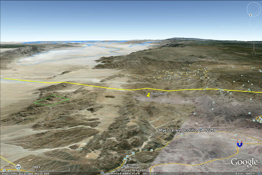
Based on the Reader story I pinned Pinto Canyon on GE and made an image looking south towards Mexico. I could see that entire are filled with water hundreds of years ago and a ship sailing up from the Gulf. Check out how many pictures in Panoramio there are of La Rumorosa...dang. It definitely looks like Clark Lane would be the way to go but the article says BLM has closed it.
--
http://www.sefcik.com
http://www.darensefcik.com
http://www.carrizogorge.com
|
|
|
link
|
|
surfponto Administrator Posts: 1369
12/4/2010
|
Great I will see you there hopefully.
I like your idea of the Sacatone Overlook hike or the Meyer hike.
Bob
dsefcik wrote:
Bob, I will be at the rally if nothing major comes up. I suggest instead you/I take the opportunity to just mozy on over across the road from the rally to Sacatone Overlook and hike down to the Palm Grove you have been wanting to go check out for so long. The overlook is 2 miles east on a dirt rd from the sign in McCain Valley. If not I would be up for the myer valley hike also.
Daren
--
https://www.anzaborrego.net/
|
|
|
link
|
|
surfponto Administrator Posts: 1369
12/4/2010
|
Thanks David,
I thought they mentioned something about a ship pictograph.
Will have to reread that.
That is a pretty "rugged" area of the Anza Borrego Desert, so it would be good to hike that with a few people.
Bob
hikerdmb wrote:
Bob,
Here is the link to the Reader article I couldn't find before.
http://www.sandiegoreader.com/news/2009/jun/03/cover/
It seems like the rock art here is petroglyphs and not pictographs but I can't find any of my old pics to be sure. The Reader article may have some useful info for you. I also sent you a PM to your ***runner account with an attachment of a topo map of the area and some more info.
David
--
https://www.anzaborrego.net/
|
|
|
link
|
|
dsefcik Administrator Posts: 2634
12/5/2010
|
Check out this guys pics and links:
http://nexthill.com/Photo's/Pinto/index.htm
http://nexthill.com
Sorta almost makes me not want to go there after seeing all the trash in his pics.
And technically, it is not part of ABDSP, it is BLM
http://www.blm.gov/ca/pa/wilderness/wa/areas/jacumba.html
--
<em>edited by dsefcik on 12/5/2010</em>
--
http://www.sefcik.com
http://www.darensefcik.com
http://www.carrizogorge.com
|
|
|
link
|
|
surfponto Administrator Posts: 1369
12/5/2010
|
I agree.
Looks like a pretty sketchy area. Intriguing but sketchy.....
Bob
dsefcik wrote:
Check out this guys pics and links:
http://nexthill.com/Photo's/Pinto/index.htm
http://nexthill.com
Sorta almost makes me not want to go there after seeing all the trash in his pics.
--
https://www.anzaborrego.net/
|
|
|
link
|
|
spaugh Posts: 1
1/17/2011
|
just an FYI, those pictures posted are not of pinto canyon. I know the area where those were taken and they are smugglers cave and some other oasis near I8 and mountain spring. There won't be trash like that in pinto canyon or davies valley. They are further off the beaten track. The only people in davies or pinto are boarder patrol and international travelers.
|
|
|
link
|
|
surfponto Administrator Posts: 1369
1/18/2011
|
Hello and welcome,
Thanks for the info. I have yet to get out to that area.
I tend to stay in the Park but there are areas in Jacumba I want to check out also.
Post some pics if you have any to share. 
Bob
spaugh wrote:
just an FYI, those pictures posted are not of pinto canyon. I know the area where those were taken and they are smugglers cave and some other oasis near I8 and mountain spring. There won't be trash like that in pinto canyon or davies valley. They are further off the beaten track. The only people in davies or pinto are boarder patrol and international travelers.
--
https://www.anzaborrego.net/
|
|
|
link
|
|
dsefcik Administrator Posts: 2634
1/18/2011
|
spaugh wrote:
just an FYI, those pictures posted are not of pinto canyon. I know the area where those were taken and they are smugglers cave and some other oasis near I8 and mountain spring. There won't be trash like that in pinto canyon or davies valley. They are further off the beaten track. The only people in davies or pinto are boarder patrol and international travelers.
You are probably correct technically...his post,pics and topo map show he descended down Myer Valley and did not go into Pinto Canyon. He mentions a "cliff" deterred him from going down into Pinto Canyon.
Thanks for the clarification.
Daren

--
--
http://www.sefcik.com
http://www.darensefcik.com
http://www.carrizogorge.com
|
|
|
link
|