Anything about Anza Borrego that does not fit into one of the other forums.
Hike from Culp Valley to Maindenhair Falls to road
|
kylekai Posts: 82
10/20/2013
|
Anyone ever hike from the Culp Valley campground to the parking area for Maindenhair Falls? I'm guessing about 5 miles? I was going to hike down and meet my wife at the Maindenhair Falls parking area, but not sure how far or long the hike will take. Thanks for any info!
|
|
|
link
|
|
dsefcik Administrator Posts: 2634
10/21/2013
|
The CRHT (California Riding and Hiking Trail) should dump out right near or at there. I have only gone half way and then cross countried down towards Hell Hole. Check out the Visitor Map
http://caltopo.com/map?id=221S
--
http://www.sefcik.com
http://www.darensefcik.com
http://www.carrizogorge.com
|
|
|
link
|
|
dsefcik Administrator Posts: 2634
10/21/2013
|
Oh yeah, a woman who was coming up said it was 6 miles.
--
http://www.sefcik.com
http://www.darensefcik.com
http://www.carrizogorge.com
|
|
|
link
|
|
kylekai Posts: 82
10/21/2013
|
That's what I thought. Thanks!
|
|
|
link
|
|
Buford Posts: 468
10/21/2013
|
+1 on the info from dsefcik. Last year I did the walk from Culp Valley to the Hellhole canyon trail to Palm Canyon. The CRHT was easy to follow and had some great views of the desert floor from Culp Valley to the maidenhair falls trail. 5-6 miles sounds about right.
--
Links to my photos: ABDSP photos, Bighorn sheep photos, ABDSP time lapse video, Wildlife photos (mainly birds)
|
|
|
link
|
|
kylekai Posts: 82
10/22/2013
|
My mistake. I thought the trail from Culp Valley to the parking lot for the Maidenhair Falls trail went past the falls. But it appears the only way down is the CRHT which more or less parallels Hellhole Canyon and then ends up at the Maidenhair Falls parking lot. Is it possible to go from Culp Valley to the Maidenhair Falls and then hike from there to the parking lot? I've head that getting around the falls from the west end may not be possible -- too steep or something. Anyone know about this?

edited by kylekai on 10/22/2013
|
|
|
link
|
|
dsefcik Administrator Posts: 2634
10/23/2013
|
Sorry but my only experience is cutting down towards the falls but not all the way down. That was when I counted sheep one year so we were still up above the falls a bit.
--
http://www.sefcik.com
http://www.darensefcik.com
http://www.carrizogorge.com
|
|
|
link
|
|
mrkmc Posts: 87
10/24/2013
|
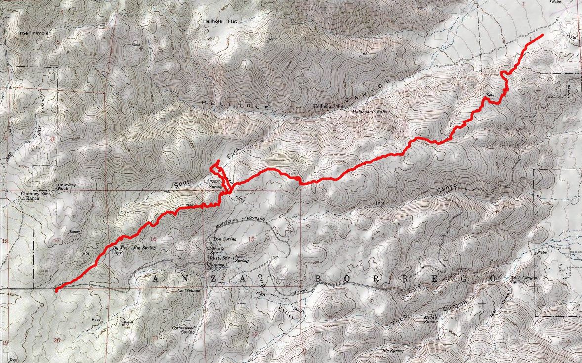
Here is a map of the CRHT. (minus the detour we took to look around the south fork) Its not shown on the Topo. As you can see, the trail stays up on the ridge. If you want to go from Culp down to the falls, it will be mostly cross country, about 2 miles with 1600' descent. It could be done, but be prepared for a steep boulder hopping descent and brush in the canyon bottoms.
|
|
|
link
|