|
stewart Posts: 25
2/14/2011
|
Newly-minted member here, first post.
Any renewed interest in this hike, for next month (or so)?
--stewart
|
|
|
link
|
|
dsefcik Administrator Posts: 2634
2/14/2011
|
I have planned it many times but never executed. How about this weekend? Sat/Sun/Mon ?
--
http://www.sefcik.com
http://www.darensefcik.com
http://www.carrizogorge.com
|
|
|
link
|
|
stewart Posts: 25
2/14/2011
|
Thanks for the quick response. Clark Lake a ten-plus hour drive for me, unfortunately, so is something I have to plan for. My third weekend in March is open, and though I'd rather not do the trip in April's heat could probably find time that month, too. It can be a hot hike, angled toward afternoon sun, etc.
I'm not geared up for backpacking right now, so have a little prep work to do.
It's been 11 years since I've been in Anza but have done the Jerry Schad route at least once, plus additional wanderings through that area.
I'm not as young as I once was (I'm 55), so would definitely need to do the up/down in three days (two nights). But no problems hiking with others who might want to do a quicker, shorter trip. There are some untouched Indian sites in the area I'd like to re-locate, if there's time. Plus, I have a mild fantasy of dragging additional water up there for a third night (and possibly a whack at Rabbit Peak), but that may be an utter pipe dream--Rabbit is a monster. There's a route (on the topo) that leads over toward Rabbit, south of the Schad route; might be interesting. The Santa Rosa ridge alternates between a cakewalk and kind of hurt-you-bad hell; I've learned not underestimate it.
I'll try to put some pics of my 2000 trip. Gotta remember how to unlock the site, plus make pasta at 2:00, so might not get to it that quickly.
|
|
|
link
|
|
stewart Posts: 25
2/14/2011
|
Here's the link:
http://technopeasant.org/
click on ANZA 2000
Not too many photos, had my first digital camera along, a 1.2 megapixel.
|
|
|
link
|
|
dsefcik Administrator Posts: 2634
2/14/2011
|
stewart wrote:
Here's the link:
http://technopeasant.org/
click on ANZA 2000
Not too many photos, had my first digital camera along, a 1.2 megapixel.
Those are great pictures!
I think you have motivated me to go. The idea of bringing water and stashing it 1/2 or 3/4 of the way was already in my plans. Spring break is definitely a possibility of going up. Let us know more about what you may be planning. I may still try this weekend despite the rain forecast.
Daren
--
http://www.sefcik.com
http://www.darensefcik.com
http://www.carrizogorge.com
|
|
|
link
|
|
stewart Posts: 25
2/15/2011
|
At the moment, it looks as though the 18th (Friday) or 19th of March would work. I'll be arriving late in the day, but hoping to hit Clark Lake well before dark. I'd rather not four wheel in the dark, esp. in the vicinity of the Clark Lake mud wallow (crappy headlights). It's also very helpful to nail down the parking location while it's still light, in the event of a return in the dark (no GPS). I noticed from my photographs that I did just that in 2000 (the nighttime hike was really fun, magical, even, but I'd forgotten it was this trip where that occurred).
I'm also remembering more clearly that back in 2000 my route up was an "Indian route," that lies to the south of the Schad route. It was a gradual incline, to a lower spot on the Santa Rosa ridge, where I camped for the night. I remember this thought as I gained the ridge: "Hey, that wasn't so bad..." I used Schad's route to return (there's a photo shot from the top of 6582 looking down the Schad route), but clearly, I didn't leave myself enough time, and arrived at Corp benchmark at the last light of twilight. The route finding above Corp is somewhat tricky in the dark. With enough water, one simply camps and hikes out in the morning.
There are several other ways to exit this area. Besides corp, one can head directly for Hidden Spring, over hill and dale, then veer left just above lower Rockhouse Canyon, and hike down a ridge parallel to the dirt road. I've also hiked straight over into Rockhouse basin from this area--something I recommend if one enjoys suffering.
These are all things one decides once out there, of course, based on leg strength and water supplies. The Schad route lends itself well to fast, young legs, not my style anymore. Hence the two night-three day plan.
I'm off now to gather my maps; will have something more intelligent to say soonly.
|
|
|
link
|
|
stewart Posts: 25
2/15/2011
|
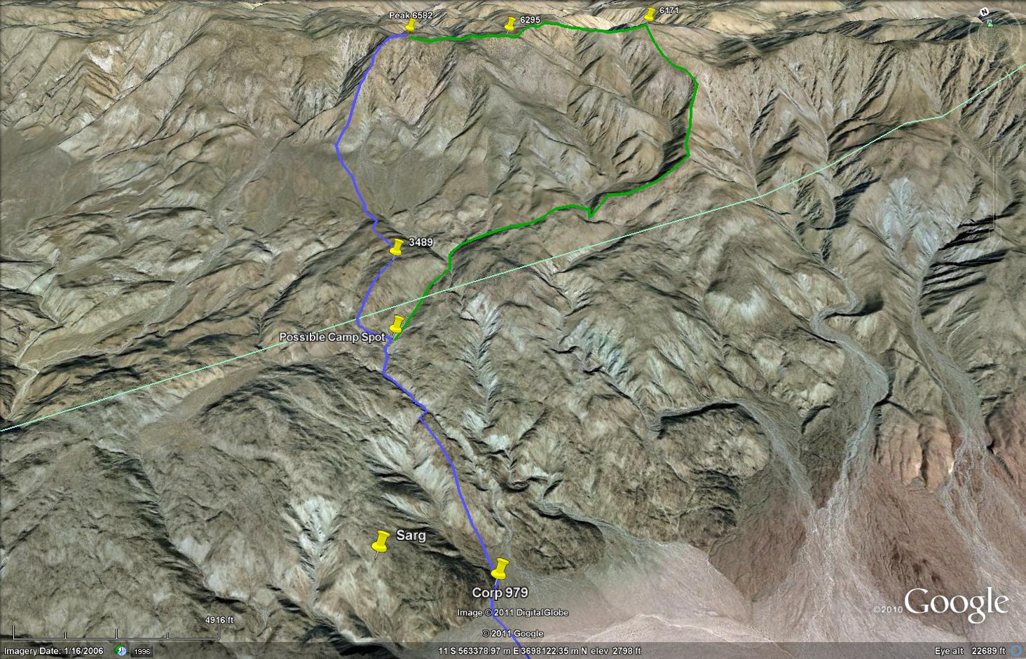
Okay, got the maps. Take a look at the Clark Lake NE 7.5 minute map (downloadable as a pdf from USGS) and go north from the Corp benchmark to peak 3489. Just to the right of the peak is a "Y" shaped watercourse. Schad's route goes up the left arm of the Y and then more or less direct to peak 6582. I went up the right arm, and hit the ridge at peak 6171. The next morning I must have hiked north along the ridge, past peak 6295 to peak 6582. That added distance explains why I didn't get back to Corp until dark. Plus I was probably goofing off, taking pics of flowers, etc.
Coupla ways to do this hike:
1. make a base camp at 3489 (or nearby) and do 6582 the next day, with a little time to explore the area.. This is the "easiest" plan, and would also keep the two day option for anyone who wanted to summit 6582 and then return to vehicles.
2. camp at 3489 first night then drag carcass and sufficient water to ridge and camp one night up there, Summit 6582 and return to vehicles on third day.
The nighttime view from the top is nice, but frankly, it is a view of civilization, after all, bright lights and all that foolish merde. Might be nicer to spend both nights down with the ghosts of Indians, enjoying the dark starry sky, etc. Plenty of bighorn sheep in this area, owls, maybe a mountain lion, even. Oops, just noticed it's a full moon on the 19th. So much for stars. At least that adds a safety factor in case anyone winds up wandering around in the dark.
|
|
|
link
|
|
dsefcik Administrator Posts: 2634
2/15/2011
|
Hey Stewart, thanks for all the info..it is very helpful. I had planed a trip out the 19th with a friend of mine and we were thinking of doing the full Rockhouse Valley tour. He may be up for 6582 instead. The full moon that weekend is actually at 11am so I think we would still be good for a dark night. We are probably gonna drive out Friday and camp at CDL and then hike/backpack Sat/Sun and drive home Sunday. I know I wouldn't mind poking around the whole area between Corp 979 and Rockhouse Canyon. A full loop thru there might be interesting also.
So barring any horrible weather we will be out there that weekend, lets try to meet up and hopefully hike out together.
Daren
<em>edited by dsefcik on 2/15/2011</em>
--
http://www.sefcik.com
http://www.darensefcik.com
http://www.carrizogorge.com
|
|
|
link
|
|
dsefcik Administrator Posts: 2634
2/15/2011
|
Here is a pic of the route I had sketched out last year and was almost certain it followed Schads course description. My path is in blue, I added your path described in green, does that look accurate to you?
I create these routes in google earth by overlaying a topo map on the terrain, they are fairly accurate (or at least have been so far for me).
--
http://www.sefcik.com
http://www.darensefcik.com
http://www.carrizogorge.com
|
|
|
link
|
|
stewart Posts: 25
2/16/2011
|
Yes, that's it. There's also appears to be a route directly up to peak 6295 that I've not tried. For some reason I chose, in 2000, not to go that way. Another interesting variation is at the base of 6582, the knife ridge just to the north of Schad's route, where the lowest steep stuff is. I remember looking over at that when I descended thinking how cool it would be to hike up that way.
I've camped at the "possible camp spot," a couple of times, once with my wife. There's a nice sandy wash in there. But also, the hills in that area are fairly smooth-topped so one can camp in many places. That wash is down low, as washes tend to be, so less of a view than surrounding hill tops. And as you probably know, washes tend to be colder at night, as cool air flows downhill from higher up. Cool might be good (or not), if days are warm. I've been rained on in there, if you can believe it, on my way to Rockhouse, rained on up in Nicolias Canyon, too. But I expect in March our only weather concern will be heat during the daytime on the way up. Climbing up to 6582 without a full pack is starting to sound sort of nice.
|
|
|
link
|
|
dsefcik Administrator Posts: 2634
2/16/2011
|
Just saw this: http://theabf.org/event/archaeology_and_history/clark_lake_petroglyphs_0
Looks like a group will be out on the 20th exploring the glyphs in the area. No sure if I consider that good or bad...humm..
--
http://www.sefcik.com
http://www.darensefcik.com
http://www.carrizogorge.com
|
|
|
link
|
|
stewart Posts: 25
2/17/2011
|
That looks like a Sunday morning hike, and we will probably be climbing 6582 on Sunday, so may not see this group at all. Doesn't sound as though they'll leave the desert floor, either.
My plan on this end is to drive down Friday, begin hiking Saturday. Climb up to the ridge and climb 6582 or whatever Sunday, hike down Monday. Drive home Tuesday. There's plenty of wiggle room in there, I hope, for side trips, or possibly a return through Rockhouse.
The popularity of this area has increased since I was last there, no doubt. Jerry Schad's book is likely to be a big factor in that--Afoot and Afield was my bible when I lived in Leucadia in the nineties.
|
|
|
link
|
|
surfponto Administrator Posts: 1369
2/20/2011
|
Hey Stewart,
Welcome to the forum. 
Sounds like you have a lot of experience in Anza Borrego. Will check out some of your pics.
The hike sounds hardcore. I really like that area, and would like to spend more time exploring up there. We rarely venture north of Indian Valley off the S2 and know that area pretty well.
Funny but we live in Leucadia now and have been here about 16 years after a brief 3 year stint on Kauai.
Heading out to Borrego today to hike around Piedras Grandes. Pouring rain in Leucadia, but the Doppler is showing it clear in Ocotillo so we are going to chance it,
Bob
stewart wrote:
That looks like a Sunday morning hike, and we will probably be climbing 6582 on Sunday, so may not see this group at all. Doesn't sound as though they'll leave the desert floor, either.
My plan on this end is to drive down Friday, begin hiking Saturday. Climb up to the ridge and climb 6582 or whatever Sunday, hike down Monday. Drive home Tuesday. There's plenty of wiggle room in there, I hope, for side trips, or possibly a return through Rockhouse.
The popularity of this area has increased since I was last there, no doubt. Jerry Schad's book is likely to be a big factor in that--Afoot and Afield was my bible when I lived in Leucadia in the nineties.
<em>edited by surfponto on 2/20/2011</em>
--
https://www.anzaborrego.net/


|
|
|
link
|
|
surfponto Administrator Posts: 1369
2/20/2011
|
Your pics are great, even with the 1.2 mega pixel camera 
Looks like a great area.
Bob
stewart wrote:
Here's the link:
http://technopeasant.org/
click on ANZA 2000
Not too many photos, had my first digital camera along, a 1.2 megapixel.
--
https://www.anzaborrego.net/
|
|
|
link
|
|
stewart Posts: 25
2/20/2011
|
Bob, glad you liked the pics. I've just started to pull old files to load online. Is a daunting task, and some pics I recognize but never labeled as to location. And as I look over the Kodachrome stuff, find that my Carrizo Gorge photos never got scanned. I once saw a couple of guy riding a battery powered cart on those rails, complete with a trailer (for their cooler of beer). They just carried the cart over the rough bits, had lawn chairs tied to the cart to ride in comfort,, etc.
That 1.2 megapixel was Olympus' first stabilized digital camera with a 10x zoom, with a second digital screen in the eyepiece. Good lens, I think, very sharp, maybe better than my current camera, Canon's sx20.
Consider joining us on this hike. With a map in hand I can show you numerous routes in the area for future consideration. There's a ancient painting out in the Rockhouse area that I've yet to see any mention of, and a healthy spring full of water, too.
A local fellow up here (SF Bay Area), Richard, I'm hoping will join the hike, too.
If you're familiar with multi-day backpacking, there are only a couple of parts of this trip that will be sort of tough. The climb from Corp with a full pack (40-45 lbs) is a bit of a sweat, since it involves some scrambling. And were we to try to camp on the Santa Rosa Ridge, climbing up there with full packs is difficult, too. But if a water camp were made down lower, then the second day will be easier than the first, because though the elevation gain is severe, only water for a day hike is needed.
The area below 6582 can be quite sublime this time of the year. Rockhouse Basin I've always found to be sort of gloomy, for some reason, but the foothills below 6582 usually bask in sunshine, have nice views, etc. And with three days to do the route, there's no rush.
If you have any questions about waterless backpacking, don't hesitate to ask. It involves stripping out all the non-essential gear and replacing that weight with water, 5 quarts per 24 hours. On a three day/two night trip, three gallons of water plus an extra quart or so, is enough, in mild temps. No coffee, alcohol, tea, or anything other such diuretic.
--Stewart
|
|
|
link
|
|
surfponto Administrator Posts: 1369
2/20/2011
|
Sounds like a great backpack trip. Will definitely give it some thought.
Great story about the guys with the electric cart.
Ask Daren what we saw the last time we hiked to Goat Canyon along the tracks.
None of us could believe it.
Found some new pictographs today around Piedras Grandes.
Will post some pics tomorrow.
Crazy weather up at Mt. Laguna and the Tecate Divide.
Tons of snow (by San Diego standards )
Bob
stewart wrote:
Bob, glad you liked the pics. I've just started to pull old files to load online. Is a daunting task, and some pics I recognize but never labeled as to location. And as I look over the Kodachrome stuff, find that my Carrizo Gorge photos never got scanned. I once saw a couple of guy riding a battery powered cart on those rails, complete with a trailer (for their cooler of beer). They just carried the cart over the rough bits, had lawn chairs tied to the cart to ride in comfort,, etc.
That 1.2 megapixel was Olympus' first stabilized digital camera with a 10x zoom, with a second digital screen in the eyepiece. Good lens, I think, very sharp, maybe better than my current camera, Canon's sx20.
Consider joining us on this hike. With a map in hand I can show you numerous routes in the area for future consideration. There's a ancient painting out in the Rockhouse area that I've yet to see any mention of, and a healthy spring full of water, too.
A local fellow up here (SF Bay Area), Richard, I'm hoping will join the hike, too.
If you're familiar with multi-day backpacking, there are only a couple of parts of this trip that will be sort of tough. The climb from Corp with a full pack (40-45 lbs) is a bit of a sweat, since it involves some scrambling. And were we to try to camp on the Santa Rosa Ridge, climbing up there with full packs is difficult, too. But if a water camp were made down lower, then the second day will be easier than the first, because though the elevation gain is severe, only water for a day hike is needed.
The area below 6582 can be quite sublime this time of the year. Rockhouse Basin I've always found to be sort of gloomy, for some reason, but the foothills below 6582 usually bask in sunshine, have nice views, etc. And with three days to do the route, there's no rush.
If you have any questions about waterless backpacking, don't hesitate to ask. It involves stripping out all the non-essential gear and replacing that weight with water, 5 quarts per 24 hours. On a three day/two night trip, three gallons of water plus an extra quart or so, is enough, in mild temps. No coffee, alcohol, tea, or anything other such diuretic.
--Stewart
--
https://www.anzaborrego.net/
|
|
|
link
|
|
stewart Posts: 25
3/12/2011
|
Checking in:
Still planning to arrive Friday at around sunset. May hike across desert to CORP that evening, if time and energy allow.
I have it in my head that I can stay out there for three nights, but two nights and three days will be more realistic.
Three nights means hand-carrying an extra gallon of water to at least the foothills below Dawns Peak. Not sure I'm up for that.
For anyone that wants to connect, either this week, or during the day Friday:
email: info@technopeasant.org
cell phone: 415-515-3132
vehicle: 1995 Toyota Tacoma, 4x4, dark gray with matching shell. I forget the license plate, but there's a YZK in it, I think.
Rather than park in the usual location (on Rockhouse road, due south of CORP), am hoping to park further in, past Butler Canyon, at the mouth of Rockhouse Canyon.
This location gives a slight downhill hike to CORP, hiking with the washes rather than across them.
If anyone joins me, I am, of course, totally open to other considerations.
Hope to see you out there!
--Stewart Gilbert
|
|
|
link
|
|
dsefcik Administrator Posts: 2634
3/12/2011
|
Thanks Stewart, I was actually gonna respond today as I was finally able to get confirmation from my friend what days he can go and it turns out only Sat/Sun. He needs to be back Sunday evening so I think we are just gonna do single over night trip in Indian Valley. If anything changes I will let you know. Be sure to post a trip report when you get back, I am sure it will be a great trip!
Daren
--
http://www.sefcik.com
http://www.darensefcik.com
http://www.carrizogorge.com
|
|
|
link
|
|
stewart Posts: 25
3/12/2011
|
Okay, thanks, Daren, for checking in. I'll post the trip on my website when I get back.
--Stewart
|
|
|
link
|
|
surfponto Administrator Posts: 1369
3/16/2011
|
Hey Stewart,
A trip report would be great.
We will be heading out Saturday AM for an overnight trip to Indian Valley or Mortero Canyon.
My sister and her boyfriend want to see wildflowers.
I have heard their may be some weather coming in but so far it looks pretty minor.
stewart wrote:
Okay, thanks, Daren, for checking in. I'll post the trip on my website when I get back.
--Stewart
<em>edited by surfponto on 3/16/2011</em>
--
https://www.anzaborrego.net/
|
|
|
link
|
|
stewart Posts: 25
3/18/2011
|
Even though I know both of you, Daren and Bob, have other plans, I thought I'd post my change in plans:
We're getting knocked around a bit by a storm (I live on a boat), and the forecast for AB is wind, so I'm delaying departure one day. Now hoping to arrive in AB Saturday at sunset or so.
FYI
--Stewart
|
|
|
link
|
|
surfponto Administrator Posts: 1369
3/18/2011
|
Good luck Stewart.
We are heading out Saturday AM also.
I think we are camping in the Indian Valley South Fork.
Bob
--
https://www.anzaborrego.net/
|
|
|
link
|
|
dsefcik Administrator Posts: 2634
3/18/2011
|
We are shooting for the north fork...but plans do change...
--
http://www.sefcik.com
http://www.darensefcik.com
http://www.carrizogorge.com
|
|
|
link
|
|
surfponto Administrator Posts: 1369
3/18/2011
|
Cool we will look for you on Saturday
dsefcik wrote:
We are shooting for the north fork...but plans do change...
--
https://www.anzaborrego.net/
|
|
|
link
|