|
dsefcik Administrator Posts: 2634
1/12/2015
|
Tom and I did a quick single overnight backpack up into the Fish Creek Mtns. According to the ABDSP visitor map there are a lot of areas you can explore in the Fish Creek Mtns that won't take you into the Carrizo Impact Area which is closed to public access. We hiked around the Fish and Eagle peaks area which is BLM territory. Pretty interesting area, you can find old mining sites and some old artillery shrapnel buried into the hillsides.
Sunset near the railroad tracks

Checking my maps while I was waiting for Tom to show up

Fish Peak in the distance

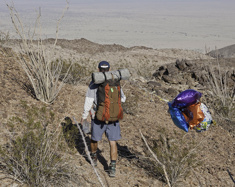
Spotted some balloons way off in the distance, as I hiked over to get them they blew away off into the opposite direction

But ultimately I got them...at the expense of Tom taking a break and waiting for me to go scale another ridge to get them

Lots of remains of the mining efforts in those hills are still there


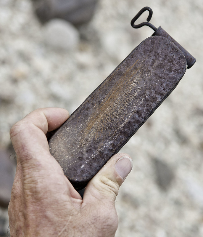
You can find left over artillery and shrapnel in the hills


There are several pieces of shrapnel in this photo, can you find them? The rusted color of the steel blends right in with the natural desert patina of the boulders

Sunrise before we head to go back to the trucks

Total Mylar Balloons this trip - 13

Tom has a few good photos also, hopefully he will post them
--
http://www.sefcik.com
http://www.darensefcik.com
http://www.carrizogorge.com
|
|
|
link
|
|
AdventureGraham Posts: 170
1/12/2015
|
Looks like a fun outing into those hills. Way to go on getting those balloons! Oh, and I love your truck!
|
|
|
link
|
|
ziphius Posts: 911
1/12/2015
|
Wait a minute... is that an antique UNOPENED can of sardines? Yum. 13 mylars for a single overnight is pretty darn good, must not be too many collectors in that area.
--
http://www.coyotelearning.org
|
|
|
link
|
|
dsefcik Administrator Posts: 2634
1/12/2015
|
Jim (ziphius) wrote:
Wait a minute... is that an antique UNOPENED can of sardines? Yum. 13 mylars for a single overnight is pretty darn good, must not be too many collectors in that area. naw...notice the church key on the lower right, the can is turned over.
--
http://www.sefcik.com
http://www.darensefcik.com
http://www.carrizogorge.com
|
|
|
link
|
|
tommy750 Posts: 1086
1/12/2015
|
Here's a couple more pics from the trip.
Daren with a mylar parade:
 Mylar parade by tomteske, on Flickr Mylar parade by tomteske, on Flickr
More tins. Pretty much a vegetarian so wasn't familiar with the term "kippered."
 Kippered by tomteske, on Flickr Kippered by tomteske, on Flickr
Aaannd Daren's life insurance premiums just doubled 
 Just Looking by tomteske, on Flickr Just Looking by tomteske, on Flickr
|
|
|
link
|
|
dsefcik Administrator Posts: 2634
1/12/2015
|
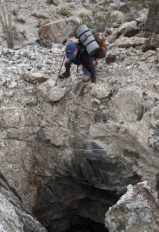
Totally Safe...don't you see my hiking pole holding me steady?? No way that rock under my left hand will slip loose...
Nice Tom, thanks for sharing those...
tommy750 wrote:
Aaannd Daren's life insurance premiums just doubled
--
http://www.sefcik.com
http://www.darensefcik.com
http://www.carrizogorge.com
|
|
|
link
|
|
hikerdmb Posts: 423
1/13/2015
|
Looks like an interesting area. Could you see the bottom of that shaft?
|
|
|
link
|
|
dsefcik Administrator Posts: 2634
1/13/2015
|
hikerdmb wrote:
Looks like an interesting area. Could you see the bottom of that shaft? Zoomed in sorta...the hole went further in at an angle

--
http://www.sefcik.com
http://www.darensefcik.com
http://www.carrizogorge.com
|
|
|
link
|
|
anutami Posts: 491
1/13/2015
|
Nice, you guys got pretty far back in there. Daren, your maps look sweet and have great detail. Where did you get those?
What is the deal with the carrizo impact area anyway? Are they still doing bombing drops out there, and why can't you venture in there?
|
|
|
link
|
|
dsefcik Administrator Posts: 2634
1/13/2015
|
Nolan (anutami) wrote:
Nice, you guys got pretty far back in there. Daren, your maps look sweet and have great detail. Where did you get those?
What is the deal with the carrizo impact area anyway? Are they still doing bombing drops out there, and why can't you venture in there? ABDSP acquired a large chunk of the impact area and for the time being is closed to public access. There is not any active bombing there (I know of) but there are signs posted near Plaster City on both sides of the RR tracks. I have heard rumors that the impact area may be cleaned up enough to allow public use but that seems unlikely but I am hopeful.I used the ABDSP maps provided here to navigate our way around the impact area boundaries. The map you see on my truck bed is one of the Tom Harrison Maps. They make pretty good durable and water resistant maps.
--
http://www.sefcik.com
http://www.darensefcik.com
http://www.carrizogorge.com
|
|
|
link
|
|
ziphius Posts: 911
1/13/2015
|
I dunno, I look at this photo and immediately think that some kind of giant spider lives down there. Daren, by the way, Alex and I tried the drop-the-stick-down-the-spider-hole trick on six different burrows in the Potrero and struck out! You were lucky.
tommy750 wrote:
Aaannd Daren's life insurance premiums just doubled
edited by ziphius on 1/13/2015
edited by ziphius on 1/13/2015
--
http://www.coyotelearning.org
|
|
|
link
|
|
anutami Posts: 491
1/14/2015
|
dsefcik wrote:
Nolan (anutami) wrote:
Nice, you guys got pretty far back in there. Daren, your maps look sweet and have great detail. Where did you get those?
What is the deal with the carrizo impact area anyway? Are they still doing bombing drops out there, and why can't you venture in there? ABDSP acquired a large chunk of the impact area and for the time being is closed to public access. There is not any active bombing there (I know of) but there are signs posted near Plaster City on both sides of the RR tracks. I have heard rumors that the impact area may be cleaned up enough to allow public use but that seems unlikely but I am hopeful.I used the ABDSP maps provided here to navigate our way around the impact area boundaries. The map you see on my truck bed is one of the Tom Harrison Maps. They make pretty good durable and water resistant maps.
Thanks, found this sd reader article although it is pretty old http://www.sandiegoreader.com/news/2001/sep/06/risky-wasteland/#
|
|
|
link
|
|
dsefcik Administrator Posts: 2634
1/14/2015
|
Nolan (anutami) wrote:
Thanks, found this sd reader article although it is pretty old http://www.sandiegoreader.com/news/2001/sep/06/risky-wasteland/#
Probably still all about the same, I don't think much has changed since then.
--
http://www.sefcik.com
http://www.darensefcik.com
http://www.carrizogorge.com
|
|
|
link
|