9 days ago
Topic:
Middle Ysidro
tekewinPosts: 365
|
deborah wrote:
That injury sounds like it was rough - good to hear you are back at it! And nice job reaching the peak. It's a good feeling when you get a "project" completed.
Deborah, thanks for the kind words. The break could have been much worse. At least I didn't need surgery. The only thing I can't do on it now is sustained jogging, but it doesn't hamper my hiking plans. I missed the meaty part of desert season, but the mountains aren't going anywhere.
|
|
|
10 days ago
Topic:
Middle Ysidro
deborah Posts: 115
|
That injury sounds like it was rough - good to hear you are back at it! And nice job reaching the peak. It's a good feeling when you get a "project" completed.
|
|
|
10 days ago
Topic:
Panamint City
deborah Posts: 115
|
Great trip report! Love the pictures. I've only done a little exploring in Death Valley, and that was a long time ago. On one trip I did a really pleasant hike up to Telescope Peak. It was blazing hot on the desert floor, but the temps on the hike were great because of the elevation. This is a good reminder for me to get back out there. So much I haven't seen yet.  Thanks for sharing! Thanks for sharing!
|
|
|
12 days ago
Topic:
Pinyon Wash to Harper Cabin
BrianPosts: 221
|
Britain wrote:
Wasn't there some kid that took his dad's Tahoe stuck in the squeeze and disappeared years ago also?
Yep. I think he actually went in from the other end. From Fish Creek. But the truck was found near the bottom of heart attack hill and one of the tires was completely destroyed, so he wouldn't have been able to make it out that way even if that was a 2 way road (which it isn't). I first found out about that when I was looking at Google Earth to familiarize myself with the area and someone had posted a bunch of pics from the search for the kid.
|
|
|
12 days ago
Topic:
Pinyon Wash to Harper Cabin
BritainPosts: 596
|
Wasn't there some kid that took his dad's Tahoe stuck in the squeeze and disappeared years ago also?
|
|
|
14 days ago
Topic:
Pinyon Wash to Harper Cabin
BrianPosts: 221
|
tommy750 wrote:
Was able to find the Tacoma location on GE and the news reports gave info on where the individuals were located.
Wow, the Tacoma was located much further west than I imagined. I had assumed he had driven to a point much closer to Harper Canyon since that is the way he tried to get out. Would have been much easier for him if he had walked down to Pinyon Wash.
The truck hadn't been airlifted out last September when I was there, but I didn't see it. I must have been fairly close. I was taking a friend up that canyon from Pinyon Wash and then over to see the ruins of the cabin. If I had been by myself, I might have explored a bit more and followed the wheel tracks which were still fresh at the time.
|
|
|
14 days ago
Topic:
Pinyon Wash to Harper Cabin
tommy750Posts: 1040
|
Brian wrote:
tekewin wrote:
Those blooms are amazing. Sounds like a successful trip and kudos for being kind to the biker.
Is the road OK all the way to Harper Flat or even Hapaha Flat? I've only been down that road a little ways to hike to Sunset Mountain.
That road ends at a canyon which is a short hike up to Harper Flat. The road that passes Harper Flat on the other side can be accessed 2 ways. One end goes in from Pinyon Mountain Road (which necessitates negotiating the squeeze and heart attack hill). The other end goes in from Fish Creek and passes through Hapaha Flat. The biggest obstacle I know of on that route comes just before you get to Hapaha and looks like this:
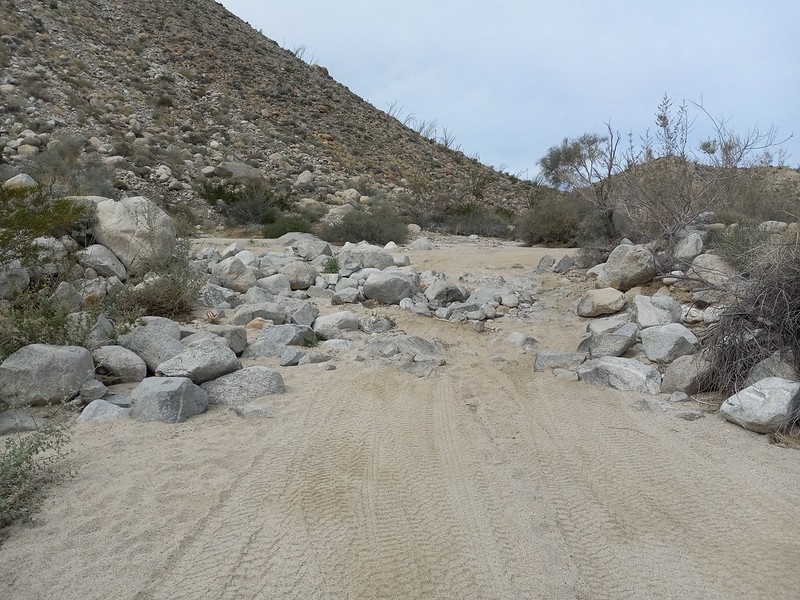
It's no longer legal to drive through Harper Flat (despite the fact someone did it last summer and was later found dead).
edited by Brian on 4/12/2024
Definitely right, Brian. That's always been the fun spot to squeeze through although I thinks someone moved a few rocks from the right side that made it a speck easier in the past couple months at least for my pickup.
Speaking of the ex-Navy Seal found dead in Harper Canyon, was wondering when someone would mention it on the forum. Here's a couple news reports if anyone is not familiar with the story:
https://www.youtube.com/watch?v=WlW6PfpO1og
https://www.youtube.com/watch?v=xZDzp74oj1w
I bumped into a knowledgeable source who mentioned the Tacoma was airlifted out of Harper Flat since it was pretty beat up. Assuming we'll never hear what really happened but a very tragic story.
Was able to find the Tacoma location on GE and the news reports gave info on where the individuals were located.
 Seal Woman and Tacoma (1) by tomteske, on Flickr Seal Woman and Tacoma (1) by tomteske, on Flickr
Gary and I walked out there a while back and found ?helo landing gear imprints in the sand but no other vehicle tracks. Didn't have the Tacoma location at the time but apparently walked within twenty feet of its prior location and didn't see anything.
 IMG_6515 by tomteske, on Flickr IMG_6515 by tomteske, on Flickr
 Track by Tacoma by tomteske, on Flickr Track by Tacoma by tomteske, on Flickr
|
|
|
14 days ago
Topic:
Pinyon Wash to Harper Cabin
surfpontoAdministrator Posts: 1362
|
Most definitely. Makes it that much more enjoyable. 👍🥾
Britain wrote:
Nice to have your wife into hiking. Mine loves it specially in the rocks.
|
|
|
14 days ago
Topic:
Pinyon Wash to Harper Cabin
BritainPosts: 596
|
Nice to have your wife into hiking. Mine loves it specially in the rocks.
|
|
|
14 days ago
Topic:
Pinyon Wash to Harper Cabin
surfpontoAdministrator Posts: 1362
|
It is a really nice hike. A little bouldering at the beginning of Pinyon Wash but nothing too technical
Here is a shot of my wife coming up one of the sections.

tekewin wrote:
Thanks! That's great information. I might try a hike to Harper Flat from Pinyon Wash. ...I want no part of the squeeze or heart attack hill....
edited by surfponto on 4/12/2024
edited by surfponto on 4/12/2024
|
|
|
14 days ago
Topic:
Pinyon Wash to Harper Cabin
surfpontoAdministrator Posts: 1362
|
Agree. I want to spend a day or two just exploring Harper Flat 👍
Britain wrote:
I was on Granite a while back. Lots of jet traffic that day. Nice captures. I also live about 5 miles from NAF El Centro. Lol I get all the traffic to and from Yuma right over my house. It's really loud when the Blue Angles are in town. Harper flat area is a cool place to hike around and explore.
|
|
|
14 days ago
Topic:
Pinyon Wash to Harper Cabin
BritainPosts: 596
|
Brian wrote:
Britain wrote:
I always thought Harpers was a closed area for vehicles. Park maps show no vehicle trails in it. Weekend warriors.
Older topo maps do show a jeep trail going through Harpers, but it's been closed to vehicles for probably about 30 years. I hiked through there last September and saw the wheel tracks of the guy who drove in over the summer. He went around a fence that's supposed to keep it closed off from the main road.
It was fenced on the heartsttack hill side or was 10 years ago. Haven't been there for a decade or so. Indian hill area is getting trashed from wheelers and the carrizo creek area is trashed by the painted gorge wheelers.
|
|
|
14 days ago
Topic:
Pinyon Wash to Harper Cabin
BrianPosts: 221
|
Britain wrote:
I always thought Harpers was a closed area for vehicles. Park maps show no vehicle trails in it. Weekend warriors.
Older topo maps do show a jeep trail going through Harpers, but it's been closed to vehicles for probably about 30 years. I hiked through there last September and saw the wheel tracks of the guy who drove in over the summer. He went around a fence that's supposed to keep it closed off from the main road.
|
|
|
14 days ago
Topic:
Pinyon Wash to Harper Cabin
BritainPosts: 596
|
tekewin wrote:
Brian wrote:
I always thought Harpers was a closed area for vehicles. Park maps show no vehicle trails in it. Weekend warriors.
It's no longer legal to drive through Harper Flat (despite the fact someone did it last summer and was later found dead).
edited by Brian on 4/12/2024
Thanks! That's great information. I might try a hike to Harper Flat from Pinyon Wash. I want no part of the squeeze or heart attack hill. Coming from Fish Creek is a lot of driving. The Vallecito Mountains and surroundings seem like a really remote part of the park.
edited by Britain on 4/12/2024
|
|
|
14 days ago
Topic:
Pinyon Wash to Harper Cabin
tekewinPosts: 365
|
Brian wrote:
That road ends at a canyon which is a short hike up to Harper Flat. The road that passes Harper Flat on the other side can be accessed 2 ways. One end goes in from Pinyon Mountain Road (which necessitates negotiating the squeeze and heart attack hill). The other end goes in from Fish Creek and passes through Hapaha Flat. The biggest obstacle I know of on that route comes just before you get to Hapaha and looks like this:
It's no longer legal to drive through Harper Flat (despite the fact someone did it last summer and was later found dead).
edited by Brian on 4/12/2024
Thanks! That's great information. I might try a hike to Harper Flat from Pinyon Wash. I want no part of the squeeze or heart attack hill. Coming from Fish Creek is a lot of driving. The Vallecito Mountains and surroundings seem like a really remote part of the park.
|
|
|
14 days ago
Topic:
Pinyon Wash to Harper Cabin
BrianPosts: 221
|
tekewin wrote:
Those blooms are amazing. Sounds like a successful trip and kudos for being kind to the biker.
Is the road OK all the way to Harper Flat or even Hapaha Flat? I've only been down that road a little ways to hike to Sunset Mountain.
That road ends at a canyon which is a short hike up to Harper Flat. The road that passes Harper Flat on the other side can be accessed 2 ways. One end goes in from Pinyon Mountain Road (which necessitates negotiating the squeeze and heart attack hill). The other end goes in from Fish Creek and passes through Hapaha Flat. The biggest obstacle I know of on that route comes just before you get to Hapaha and looks like this:
It's no longer legal to drive through Harper Flat (despite the fact someone did it last summer and was later found dead).
edited by Brian on 4/12/2024
|
|
|
14 days ago
Topic:
Pinyon Wash to Harper Cabin
BritainPosts: 596
|
I was on Granite a while back. Lots of jet traffic that day. Nice captures. I also live about 5 miles from NAF El Centro. Lol I get all the traffic to and from Yuma right over my house. It's really loud when the Blue Angles are in town. Harper flat area is a cool place to hike around and explore.
|
|
|
15 days ago
Topic:
Pinyon Wash to Harper Cabin
surfpontoAdministrator Posts: 1362
|
I am guessing that is the flight path. El Centro NAF over Jojoba Wash then to the coast. It has gotten so noisy there.
Still love the area but most likely will overnight camp elsewhere in the future.
I will have to check out some of those areas you mentioned near Pinyon Wash. Haven't been over by Split Rock in a long time
Harper Flat is huge and I am sure you could spend a few days just exploring that area.
tommy750 wrote:
Nice TR, Surfponto! I feel your pain regarding the Marines flying stuff overhead. I live five miles away from El Centro NAF and see/hear/feel their big birds at all hours of the day including midnight. The Blue Angels practice here every winter and 5-6 F-18s flying overhead makes your ears ring. Have never visited Harper Cabin. Glad to hear it's surviving. Agree, Pinyon wash is a great camping spot and great starting off point for lots of hikes to Sunset, the four nearby guzzlers, Pinyon Mt, Whale, Harper Flat. Was out at Split Rock a couple months ago and met hikers coming in from Pinyon to check out the pictographs.
|
|
|
15 days ago
Topic:
Middle Ysidro
tekewinPosts: 365
|
tommy750 wrote:
I've never even heard of Middle Ysidro but looks like a great day hike. Glad you were able to recover from your ankle injury and keep going.
Haha, yeah, it's an unofficial peak with a topo mark in the middle of the range. There were no official marks on the summit. I wanted to hike there because I like the peaks on both ends of the range and it felt incomplete.
I am glad to be able to do longer hikes again and not have it be the limiting factor.
|
|
|
15 days ago
Topic:
Panamint City
tommy750Posts: 1040
|
Nice trip, Brian! A quote from the NPS site: "Panamint City was called the toughest, rawest, most hard-boiled little hellhole that ever passed for a civilized town. Its founders were outlaws..."
|
|
|
15 days ago
Topic:
Middle Ysidro
tommy750Posts: 1040
|
I've never even heard of Middle Ysidro but looks like a great day hike. Glad you were able to recover from your ankle injury and keep going.
|
|
|
15 days ago
Topic:
Pinyon Wash to Harper Cabin
tommy750Posts: 1040
|
Nice TR, Surfponto! I feel your pain regarding the Marines flying stuff overhead. I live five miles away from El Centro NAF and see/hear/feel their big birds at all hours of the day including midnight. The Blue Angels practice here every winter and 5-6 F-18s flying overhead makes your ears ring. Have never visited Harper Cabin. Glad to hear it's surviving. Agree, Pinyon wash is a great camping spot and great starting off point for lots of hikes to Sunset, the four nearby guzzlers, Pinyon Mt, Whale, Harper Flat. Was out at Split Rock a couple months ago and met hikers coming in from Pinyon to check out the pictographs.
|
|
|
15 days ago
Topic:
Pinyon Wash to Harper Cabin
tekewinPosts: 365
|
surfponto wrote:
We went via Pinyon Wash but yes the road in from the other side looked fine.
I have never gone that way and it looks interesting.
Yep the cactus flowers were great. Such a good time to take a trip out there. 👍
Thanks!
|
|
|
15 days ago
Topic:
Pinyon Wash to Harper Cabin
surfpontoAdministrator Posts: 1362
|
We went via Pinyon Wash but yes the road in from the other side looked fine.
I have never gone that way and it looks interesting.
Yep the cactus flowers were great. Such a good time to take a trip out there. 👍
tekewin wrote:
Those blooms are amazing. Sounds like a successful trip and kudos for being kind to the biker.
Is the road OK all the way to Harper Flat or even Hapaha Flat? I've only been down that road a little ways to hike to Sunset Mountain.
|
|
|
15 days ago
Topic:
Pinyon Wash to Harper Cabin
tekewinPosts: 365
|
Those blooms are amazing. Sounds like a successful trip and kudos for being kind to the biker.
Is the road OK all the way to Harper Flat or even Hapaha Flat? I've only been down that road a little ways to hike to Sunset Mountain.
|
|
|
19 days ago
Topic:
Pinyon Wash to Harper Cabin
surfpontoAdministrator Posts: 1362
|
Not an extreme hike compare to what some of you guys do but thought I would post it anyway 😉
First night we camped down in Jojoba Wash but man oh man the military air traffic was ridiculous.
The final straw was a military Osprey thundering through the sky at 1AM shaking the truck camper.
On the positive side there was an amazing cactus bloom display.
We spent the next day hiking around taking cactus pictures but decided we would camp further north the next night.

Beavertail in bloom (Jojoba Wash)

Barrel Cactus in bloom (Jojoba Wash)

Hedgehog in bloom (Jojoba Wash)
Next day we drove over to Pinyon Wash which I have now decided is my favorite area to camp. We have camped here before but it has been at least 10 years as all of our camping is usually south of Scissors Crossing.
After a better night's sleep i.e. no air traffic, we decided we would hike up to see how much was left of the old Harper Cabin site.
Last time we hiked here was on an Anza Borrego Foundation sponsored hike led by Mark Jorgensen, so we were curious as to how it has fared in the last 10 plus years.
We got an early start and reached Harper Flat by 9AM. There was a great display of Desert Dandelions covering the valley floor so of course we had to take a bunch of pictures.

A field of Desert Dandelions (Harper Flat)

Not soon after we met up with a lone mountain biker that was doing a big overnight loop from Borrego Springs, unfortunately for him, he had run out of water so we offered to fill one of his water bottles. He mentioned that he had not slept that well the previous night since he was worried about his lack of water, so we were glad to help him out.

After saying goodbye to our new friend and hiking up a couple incorrect tributaries we did find the old cabin. It was in much better shape than either of us predicted.

Old water trough which is your clue you are close to the cabin

Maybe to call it a "cabin" is a stretch but it is cool nonetheless.😀

The old dam is not going anywhere.
This thing is solid and is truly an engineering marvel considering the time period it was built.

Fishhook cactus blooming in Pinyon Wash

Beavertail blooms in Pinyon Wash
edited by surfponto on 4/7/2024
|
|
|
19 days ago
Topic:
Middle Ysidro
surfpontoAdministrator Posts: 1362
|
Looks like a beautiful area .
Thanks for sharing
|
|
|
19 days ago
Topic:
Panamint City
surfpontoAdministrator Posts: 1362
|
Really nice pictures, looks like a great trip 👍
Love the picture of the old diesel motor but I am a bit biased since we drive two diesels 😉
|
|
|
20 days ago
Topic:
Middle Ysidro
tekewinPosts: 365
|
Brian wrote:
Nice trip report. I made a half hearted attempt at the western summit last spring but ended up not wanting to deal with the amount of brush on the final approach to the ridge.
I get it. There can be a lot of brush depending on the route you take. Ysidro and the Thimble used to be short-ish hikes from Cherry Canyon. However, with that parking area gone, it's a more serious hike from S2.
|
|
|
20 days ago
Topic:
Middle Ysidro
tekewinPosts: 365
|
Britain wrote:
Nice! Looks like your back on the trails!
Yes, great to be moving again.
|
|
|
28 days ago
Topic:
Middle Ysidro
BrianPosts: 221
|
Nice trip report. I made a half hearted attempt at the western summit last spring but ended up not wanting to deal with the amount of brush on the final approach to the ridge.
|
|
|
28 days ago
Topic:
Middle Ysidro
BritainPosts: 596
|
Nice! Looks like your back on the trails!
|
|
|
28 days ago
Topic:
Middle Ysidro
tekewinPosts: 365
|
I retired on 12/13/23 and had grand plans. Middle Ysidro was early on the list. Unfortunately, on 1/1/24 I rolled my right ankle while running breaking the fibula just below the ankle joint. On vacation in Hawaii. Aloha! First broken bone in my life. Wore a boot for a month, lost half my right calf muscle, and did physical therapy for two more months. I had done a couple of small hikes in February, but this was going to be a real test.
My friend Sean and I started out from S2 just past the Anza-Borrego sign. We made our way past the Bonnie and Clyde benchmarks, then spent a couple miles side-hilling around White BM. As a bonus, I wanted to check out some granite formations that caught my attention on a previous trip. There were four towers (30'-70') on a shelf above the drainage that leads to Hob BM. I called these Hobs Knobs #1-#4. They are nearly in a direct line between The Thimble and Goat BM. Number 4 was the closest and I found an easy ledge to the top. Next, I checked out Number 1 to the east. I saw a good class 3 line using ledges and slabs. I saved the others for a future trip. We crossed the drainage and started up the ridge toward Hob. It would have been easier if we had followed the major gully east of Hob since it had less brush. After reaching the ridge line, we got a look at Middle Ysidro across a brushy saddle.


Knob #1

Me on Knob #1, hard to see

Half way up the ridge

At the base of Middle Ysidro
Sean led the route up some boulders to avoid the worst vegetation. The highest point was northeast of the false summit. The high point was a boulder requiring a single class 3 mantle. There were no marks and no register. Views from the middle of the range were striking. It took us six hours to reach Middle Ysidro. I had planned an eight hour round trip, so water and food were going to be a problem. On the way back, Sean collected some emergency water from a small snow patch and from a puddle on top of a boulder. We descended the gully and made better time. Instead of going back through Hobs Knobs, we followed the drainage, trading extra steps for an easier grade. We took frequent breaks in the shade on the way back. I rationed both food and water. Sean treated the murky water he collected with purification pills and drank up. I drank some of the snow melt, but was not keen on the boulder water. Sean's route finding was key in certain places and I don't think I would have completed this hike without his help. When we reached the truck, I guzzled the water I had, but was very dehydrated. We stopped at the Pala mini-mart on the way back and I loaded up on ice cold drinks. After downing a Gatorade, I was right as rain. I underestimated the effort required for Middle Ysidro. My ankle was sore, but with minimal swelling and no lingering pain. The ankle appears to be back in working order. Hope I can get to the desert a couple more times before it gets too hot.


Sean on the summit block

Amazing Ysidro ridge

Rest stop on the way back


Nursing the last bottle of water

11 miles, 4211' gain, 11 hours
|
|
|
28 days ago
Topic:
Panamint City
BrianPosts: 221
|
Not Anza Borrego, but I thought this trip report would still fit here.
I did a quick trip to Panamint City (Death Valley National Park) last week. Managed to get a weather window where the bottom of the hike was low 80s and the top was 60s in the day / 40s at night. Just a couple days later on the weekend, the forecast was for lows in the 20s. Glad I wasn't around for that.
This was my first time doing this hike after thinking about it for years. All of the challenges which I anticipated were there but not as bad as I feared. The road to the trailhead did have some spots that were marginal for a Subaru, but I still made it to the end. The parts where you have to walk in the stream and climb wet waterfalls were manageable. There is 3600' of gain, but that was also manageable. There was some minor bushwhacking.
The part I didn't expect - and my least favorite part of the hike - was that the last few miles which I anticipated would be on the former road often ended up in a dry rocky creek bed instead. That made for slow going and foot pain.
This used to be a road until it was washed out in 1983

Some trucks didn't make it out before the road turned into a waterfall

One of the better sections of the dry portion of the hike, after the initial 3 miles of jungly conditions

A couple views of the iconic smelter
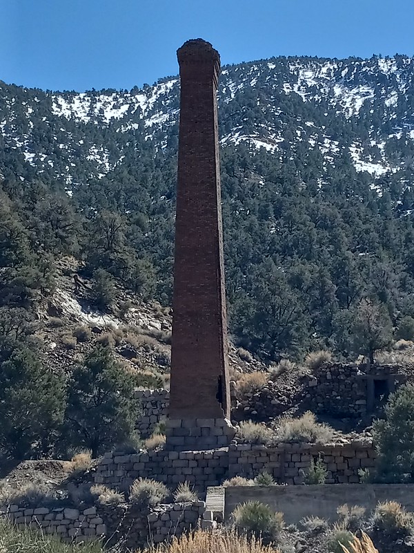

the "Panamint Hilton"

leftover equipment from the mining days


my accommodation for the night and town overview


|
|
|
3/24/2024
Topic:
upcoming? Rosa (looking for advice)
BufordPosts: 453
|
Nice ram skeleton.
I don't see any exposure on the ridge, I see a trail 
It's been windy most times I've been up in that area.
|
|
|
3/21/2024
Topic:
Knee replacement
BritainPosts: 596
|
surfponto wrote:
Glad you are able to get back out there and hope it keeps improving.
I like the solitude of that Jacumba Jim's hike.
Wife likes Jacumba Jim’s. We may end up there yet.
|
|
|
3/21/2024
Topic:
Wildflowers starting to bloom around June Wash
surfpontoAdministrator Posts: 1362
|
4 axles in a LandCruser?! dammm
DHeuschele wrote:
Heading out tomorrow to check the flowers near borrego springs (Henderson canyon and coyote canyon) with the wife. Taking the wives little Range Rover so will not be doing any 4x4 road. Two of my beast vehicles are down right now. Son managed to break a piece out of torsion bar, a king shock, and break an axel on the LC100 (4th axel he has broke in 2 years). I try to tell him the skilled drivers do not need to ram the car to do challenging 4x4 roading.
So flowers, fonts point, lunch, and serpent is probably all we will be doing.
Looking forward to it as I have not been out to ABSP yet this season. I had 2 hiking trips planned this season but had to cancel on both.
edited by DHeuschele on 3/12/2024
|
|
|
3/21/2024
Topic:
Knee replacement
surfpontoAdministrator Posts: 1362
|
Glad you are able to get back out there and hope it keeps improving.
I like the solitude of that Jacumba Jim's hike.
|
|
|
3/21/2024
Topic:
upcoming? Rosa (looking for advice)
surfpontoAdministrator Posts: 1362
|
Nice pictures
Yeah I kind of don't blame you since you were solo hiking.
Maybe we can get Daren to take a visit out west. 🤔
Brian wrote:
Rocko1 wrote:
That ridge is calling my name!
I'd try it again if I had you along for moral support. And if it wasn't super gusty.
edited by surfponto on 3/21/2024
|
|
|
3/18/2024
Topic:
Greeting!
dtoujoursPosts: 7
|
Thanks!
tekewin wrote:
Welcome!
|
|
|
3/18/2024
Topic:
upcoming? Rosa (looking for advice)
BrianPosts: 221
|
Rocko1 wrote:
That ridge is calling my name!
I'd try it again if I had you along for moral support. And if it wasn't super gusty.
|
|
|
3/18/2024
Topic:
upcoming? Rosa (looking for advice)
Rocko1Posts: 588
|
Brian wrote:
dsefcik wrote:
At least you gave it a go and spent the day out in the desert....now you have an excuse to go again..!
Exactly. It was a nice day and I used the extra time to check out the section of Coyote Canyon road between the gate closure and boulder alley.
My nemesis

Unlucky former resident of Palo Verde Canyon

They weren't kidding about Coyote Creek taking over the road

Boulder alley is back to looking the way it did in 2012

That ridge is calling my name!
|
|
|
3/16/2024
Topic:
upcoming? Rosa (looking for advice)
ScooterPosts: 111
|
That happens, makes you want to go back even more !
|
|
|
3/16/2024
Topic:
My Retriement
ScooterPosts: 111
|
Congratulations Darren !! I retired 7 years ago and never looked back. Love the ability to go mid week without the crowds.
Moved to Fountain Hills in Arizona, so many hiking trails 5 minutes from my house
Still get back to Borrego about 4 times a year. Enjoy. I hope the blog keeps going. It is so helpful
|
|
|
3/16/2024
Topic:
Greeting!
tekewinPosts: 365
|
Welcome!
|
|
|
3/16/2024
Topic:
Knee replacement
tekewinPosts: 365
|
Good job getting outside. It sounds like it was an improvement, though I am sure it was painful.
|
|
|
3/16/2024
Topic:
My Retriement
tekewinPosts: 365
|
Congrats on retirement! Even though it was a couple years ago.
Those are awesome photos. Very different critters there. I read why you chose Florida, but wow, going from one of the driest parts of the country to wettest. I love mountains too much to live somewhere flat. I don't do harsh winters any more either, so that rules out much of the country for us.
Best of luck going forward and hope you get back to the desert soon.
|
|
|
3/16/2024
Topic:
upcoming? Rosa (looking for advice)
dsefcikAdministrator Posts: 2609
|
You coulda taken that ridgeline, there is even a trail on it...🙂
|
|
|
3/16/2024
Topic:
upcoming? Rosa (looking for advice)
BrianPosts: 221
|
dsefcik wrote:
At least you gave it a go and spent the day out in the desert....now you have an excuse to go again..!
Exactly. It was a nice day and I used the extra time to check out the section of Coyote Canyon road between the gate closure and boulder alley.
My nemesis
Unlucky former resident of Palo Verde Canyon
They weren't kidding about Coyote Creek taking over the road
Boulder alley is back to looking the way it did in 2012
|
|
|
3/15/2024
Topic:
upcoming? Rosa (looking for advice)
dsefcikAdministrator Posts: 2609
|
At least you gave it a go and spent the day out in the desert....now you have an excuse to go again..!
|
|
|
3/14/2024
Topic:
upcoming? Rosa (looking for advice)
BrianPosts: 221
|
I made an attempt this morning, using the route that goes up Palo Verde canyon (this starts the same as Schad's route to Mile High). I was heavily influenced by this trip report since it said they made it to Rosa in 4 hours.
https://www.sdpeakbagger.com/2019/11/27/mile-high-mountain/
That's where I got the red track line on my map.
I made it as far as the ridge line above Palo Verde, but then I was facing a narrow ridge with steep dropoffs on both sides. My fear of heights kicked in. It didn't help that the forecast for the Santa Rosas called for possible gusts of up to 70 MPH.
I should have done the Pyramid route. I've summited Pyramid before, so I know I can make it that far. Next time.
|
|
|
3/14/2024
Topic:
Sandstone Canyon question
dsefcikAdministrator Posts: 2609
|
Buford wrote:
Isn’t there an “official” listing of all rock art in the park kept somewhere with locations?
The BARC has known documented sites in the park but I personally have found several sites not documented so there are definitely more undocumented sites waiting to be found.
|
|
|
3/14/2024
Topic:
My Retriement
dsefcikAdministrator Posts: 2609
|
Buford wrote:
As long as we don’t see you on the news with the headline “Florida man…”
Yeah, the morning radio show always has something about Florida Man.
https://floridaman.com/
--
|
|
|
3/14/2024
Topic:
Knee replacement
dsefcikAdministrator Posts: 2609
|
Britain wrote:
Find anything interesting to do in Florida?
Been mostly busy on my property,lots of tree trimming, gardening, house repairs. Finally starting to get out and explore more. There are some really pretty areas here but the mosquitoes and humidity can be tough.
|
|
|
3/13/2024
Topic:
upcoming? Rosa (looking for advice)
BufordPosts: 453
|
Good luck if you go for it.
I haven't done the yellow route on your map, can't comment on if it is better or worse.
Here is the approximate route I did both times. I took the miners trail from Palo Verde to Smoke Tree. If you don't do Pyramid, there is a native american trail that climbs from the the bottom of Smoke Tree on the west side of Pyramid and joins the ridgeline somewhere north of the peak before Marble. The benefit is once you gain the Pyramid ridgeline it is relatively easy going until the final climb to Rosa.
Don't know how all the old native american and miners trails have held up with some of the rain. Some were already hard to find and follow a couple years ago.

|
|
|
3/12/2024
Topic:
Wildflowers starting to bloom around June Wash
dtoujoursPosts: 7
|
The wildflowers are getting a little local news coverage
https://www.youtube.com/watch?v=IOeJnxZ6hZ0
|
|
|
3/12/2024
Topic:
upcoming? Rosa (looking for advice)
BrianPosts: 221
|
Thanks Buford, that's good info.
|
|
|
3/12/2024
Topic:
upcoming? Rosa (looking for advice)
BufordPosts: 453
|
I've done Rosa twice, both times as a loop starting with Pyramid, Rosa, Mile High, and Villager once.
There is a well defined trail from just north of pyramid to where the red and green lines meet. The trail follows the ridge or just off it. From where the red and green lines meet, the ascent is completely off trail. I don't remember it being particularly bad. Just steep and rocky like the rest of the desert.
I believe there is an old native american trail that goes from your "trail to Rosa" mark to the green line, if you can find it. I can't remember exactly which saddle it connects to.
|
|
|
3/12/2024
Topic:
upcoming? Rosa (looking for advice)
BrianPosts: 221
|
I would like to attempt Rosa before the season is over. This would be an out and back, not one of the loop hikes. I downloaded some tracks from Peakbagger and it looks like there are a few different routes people take. I've been to Pyramid before and was originally planning to do that again and go up from there. But after looking at the tracks, it looks like it's more direct to go up the ridge to the W of Palo Verde canyon. One thing I'm undecided on is the final approach ridge. Looks like there are 2 options (represented by the yellow and red tracks in the pic). For anyone who has done both, which do you think is better/easier?

|
|
|
3/12/2024
Topic:
Little Blair North
Rocko1Posts: 588
|
tommy750 wrote:
Another nice trip. Glad you like your new tent. Was watching a youtuber last night review "ultralight tents' and zpacks didn't make the cut (the guy's sponsor was Moosejaw, so...) but it would have been the lightest of all of them. Thought zpacks way more pricy than the competition but that's not really the case anymore. Quite happy with my altaplex. Thanks!
I know that youtuber. I really like Zpacks tents. I also like Tarptent. I think Henry Shires is genius. My Zpacks Plex Solo is pretty darn neat at 14oz. I just barely fit into it but it works.
|
|
|
3/12/2024
Topic:
Little Blair North
Rocko1Posts: 588
|
dsefcik wrote:
Rocko1 wrote:
dsefcik wrote:
Great pics. Like the camo shirt.
Thanks. Kuiu Peleton 97 lightweight fleece. I would say it's one of the best backpacking items I own. 6oz.
Looked them up, looks like nice gear, have never heard of that company before. The color Valo looks pretty cool also.
It's one of my best pieces of clothing. I don't leave home without it. Highly recommend it.
|
|
|
3/12/2024
Topic:
Wildflowers starting to bloom around June Wash
DHeuschelePosts: 87
|
Heading out tomorrow to check the flowers near borrego springs (Henderson canyon and coyote canyon) with the wife. Taking the wives little Range Rover so will not be doing any 4x4 road. Two of my beast vehicles are down right now. Son managed to break a piece out of torsion bar, a king shock, and break an axel on the LC100 (4th axel he has broke in 2 years). I try to tell him the skilled drivers do not need to ram the car to do challenging 4x4 roading.
So flowers, fonts point, lunch, and serpent is probably all we will be doing.
Looking forward to it as I have not been out to ABSP yet this season. I had 2 hiking trips planned this season but had to cancel on both.
edited by DHeuschele on 3/12/2024
|
|
|
3/12/2024
Topic:
Crowds
DHeuschelePosts: 87
|
Retired January 2022. I seem to be as busy as ever and not taking as many trips as I did pre retirement. Will be going out tomorrow to check out the flowers. May do fonts point and the serpent. I typically do a stop at the serpent.
|
|
|
3/11/2024
Topic:
Sandstone Canyon question
BufordPosts: 453
|
Isn’t there an “official” listing of all rock art in the park kept somewhere with locations? Obviously not public information though. I’d be curious what sites have faded away.
|
|
|
3/11/2024
Topic:
My Retriement
BufordPosts: 453
|
Jealous of some of the wildlife you have there. Hopefully you get back out here.
As long as we don’t see you on the news with the headline “Florida man…”
|
|
|
3/11/2024
Topic:
Wildflowers starting to bloom around June Wash
dtoujoursPosts: 7
|
Beautiful! Thanks for the report.
|
|
|
3/11/2024
Topic:
Knee replacement
dtoujoursPosts: 7
|
Good on ya getting back out there, Britain!
|
|
|
3/10/2024
Topic:
Knee replacement
BritainPosts: 596
|
dsefcik wrote:
I remember you having some knee issues awhile back, doesn't seem that long ago but I am going on almost 3 years leaving SD.
Glad you are able to get back out..👍
Find anything interesting to do in Florida?
|
|
|
3/10/2024
Topic:
Knee replacement
dsefcikAdministrator Posts: 2609
|
I remember you having some knee issues awhile back, doesn't seem that long ago but I am going on almost 3 years leaving SD.
Glad you are able to get back out..👍
|
|
|
3/10/2024
Topic:
Knee replacement
BritainPosts: 596
|
Lost my ability to hike a few years back. Tried but the knee was a mess. Finally got the balls to replace it 5 months ago. Did my first desert hike a couple weeks ago. From the waster tank by the tracks to the north west base of Piedras Grandes. Always wanted to peak it. That will need to wait I think I’ll give PAH benchmark another go when I’m capable. The 2 miles lol was a struggle but I got out. Wife wants to back to Jacumba Jims or the Carrizo creek badlands. I’ll go the bad lands, would rather fall in a rabbit hole. But it was good to get out.
|
|
|
3/10/2024
Topic:
Little Blair North
dsefcikAdministrator Posts: 2609
|
Rocko1 wrote:
dsefcik wrote:
Great pics. Like the camo shirt.
Thanks. Kuiu Peleton 97 lightweight fleece. I would say it's one of the best backpacking items I own. 6oz.
Looked them up, looks like nice gear, have never heard of that company before. The color Valo looks pretty cool also.
|
|
|
3/10/2024
Topic:
My Retriement
dsefcikAdministrator Posts: 2609
|
Would be lieing if I said I didn't miss the desert and all of you...😢
Hopefully I will make some trips back out there as life here begins to settle down 👍
|
|
|
3/10/2024
Topic:
Wildflowers starting to bloom around June Wash
surfpontoAdministrator Posts: 1362
|
Thanks Daren,
There was a lot more blooming almost a year ago to date.
Guessing a couple more weeks so will head out again.
Mid-week of course 😎👍

Last years flower fields
dsefcik wrote:
Looks nice Bob 👍
A map by the ABF is available here
https://theabf.org/wp-content/uploads/2024/03/Flower-Filed-3-A3-size-map-1.pdf
edited by surfponto on 3/10/2024
|
|
|
3/10/2024
Topic:
Four Frogs Canyon
surfpontoAdministrator Posts: 1362
|
I love this response Tom 😎
tommy750 wrote:
Nice trip, Surfponto. Driving out on a Tuesday to explore a canyon, drink a beer and drive home makes me want to quit my job right now! Daren, Gary and I went up Jacumba Jim back in 2017 and I remeber dropping into Four Frogs on the way back but haven't had a chance to explore that canyon. That row of palms on the canyon wall always has looked intriguing. Was out in Rockhouse a couple weeks ago and hiked up into McCain and above the spring that fed Rockhouse. Was aboout 11.5 miles and 2.6K g/s but probably easier than the Schad Four Frogs Jacumba Jim loop.
|
|
|
3/10/2024
Topic:
Sandstone Canyon question
dsefcikAdministrator Posts: 2609
|
I have heard reports from other people that no longer see features in the sandstone walls out there and they were definitely old.
|
|
|
3/10/2024
Topic:
Wildflowers starting to bloom around June Wash
dsefcikAdministrator Posts: 2609
|
Looks nice Bob 👍
A map by the ABF is available here
https://theabf.org/wp-content/uploads/2024/03/Flower-Filed-3-A3-size-map-1.pdf
|
|
|
3/9/2024
Topic:
Wildflowers starting to bloom around June Wash
surfpontoAdministrator Posts: 1362
|
I took a quick trip out to see how the wildflowers were progressing in southern Anza Borrego. Didn't see the extensive fields similar to last year but found flower patches that made the 2-hour drive worthwhile.
Beautiful day out there.


https://www.anzaborrego.net/2024/03/09/anza-borrego-wildflower-update-march-2024/
|
|
|
2/29/2024
Topic:
Ghosts of the Wilderness with Daniel Toujours
dtoujoursPosts: 7
|
This presentation is at Helix Brewing in La Mesa, but its theme focuses on deserts, including Anza Borrego, and the wider American Southwest region.
Ghosts of the Wilderness-Free Presentation with Daniel Toujours-Hiker, Naturalist, and Author
Daniel is an everyday guy who, like many of us, spends as much time as he can hiking during his evenings, weekends, and days off. Looking to explore more, he set out on a mission to find the iconic, but elusive American animals that he hadn't yet seen in thousands of miles of hiking. Along the way, he discovered history from the American Southwest, stumbled upon artifacts, and learned a little something about life. Please join us for an entertaining and informative talk.
This presentation is part of the Adventure 16 Wild Wednesdays Series. These fun and casual FREE presentations are aimed at Inspiring and Informing SoCal's Outdoor Community.
Wednesday, March 27, 2024
6:30pm Meet n' Drink; 7:00pm Presentation, Ends around 8pm
Food Truck on Site
Helix Brewing
8101 Commercial Street
La Mesa, CA 91942
https://adventure16.com/pages/events-1
|
|
|
2/29/2024
Topic:
Greeting!
dtoujoursPosts: 7
|
Thank you! Gosh, that's a tough one. One of the things I like about Anza Borrego is that there's always a fresh adventure you can make for yourself. That said, I like the badlands south of Truckhaven Rocks with the Salton Sea in the distance and anywhere I can see the ocotillos and smell the creosote! Do you have a favorite hike?
Brian wrote:
Welcome. What's your favorite hike in Anza Borrego?
|
|
|
2/28/2024
Topic:
Greeting!
BrianPosts: 221
|
Welcome. What's your favorite hike in Anza Borrego?
|
|
|
2/28/2024
Topic:
Greeting!
dtoujoursPosts: 7
|
Hi there, I want to introduce myself to everybody on the form. I've been a bit of a lurker off and on for a while, but looking forward to participating now. Hiking is a big part of my life and I love visiting environments throughout the American Southwest, but the desert is my true home, and Anza Borrego is my home desert. Cheers to you all!
|
|
|
2/26/2024
Topic:
Sandstone Canyon question
tommy750Posts: 1040
|
That's pretty clean! Wonder if a park volunteer helped it along.
|
|
|
2/25/2024
Topic:
Sandstone Canyon question
BrianPosts: 221
|
update:
I returned to Sandstone Canyon this weekend and used identifiable features and timestamps from my 2014 photo series to find the spot where the pictographs had been. They are almost completely gone now. I had to get very close to see any traces which confirmed I was in the right spot.
The spot is tucked in under an overhanging ledge which would have protected it from rain. Having said that, the fact they disappeared in only 10 years suggests they couldn't have been very old.


|
|
|
2/18/2024
Topic:
Sandstone Canyon question
BrianPosts: 221
|
tommy750 wrote:
Nice find. Only issue I would have is what they're painted on. The last Kumeyaay (and Cahuilla) visited Hapaha just up the wash in the 1890's and I would wonder if it would last that long on exposed sandstone. The visitor grafitti etched into the neaby rocks seems to fade rather quickly but there's lots of paint on sanstone like stuff in Utah so who knows. Will see if anyone at BARC has seen that.
I had the same thought. That plus the fact that no one seems to know about this makes me wonder if it was a fake that was recently done at the time I saw it, and has weathered away in the 10 years since then.
|
|
|
2/16/2024
Topic:
My Retriement
tommy750Posts: 1040
|
Well Daren, glad you were able to escape the grind! Can't say I don't miss you, though. Honestly have to say essentially everything I've learned in the past 10+ years about hiking/backpacking/the desert I owe to you. Thanks for the great memories and hoping you can make it out here again some time.
|
|
|
2/16/2024
Topic:
Sandstone Canyon question
tommy750Posts: 1040
|
Nice find. Only issue I would have is what they're painted on. The last Kumeyaay (and Cahuilla) visited Hapaha just up the wash in the 1890's and I would wonder if it would last that long on exposed sandstone. The visitor grafitti etched into the neaby rocks seems to fade rather quickly but there's lots of paint on sanstone like stuff in Utah so who knows. Will see if anyone at BARC has seen that.
|
|
|
2/16/2024
Topic:
Little Blair North
tommy750Posts: 1040
|
Another nice trip. Glad you like your new tent. Was watching a youtuber last night review "ultralight tents' and zpacks didn't make the cut (the guy's sponsor was Moosejaw, so...) but it would have been the lightest of all of them. Thought zpacks way more pricy than the competition but that's not really the case anymore. Quite happy with my altaplex. Thanks!
|
|
|
2/16/2024
Topic:
Four Frogs Canyon
tommy750Posts: 1040
|
Nice trip, Surfponto. Driving out on a Tuesday to explore a canyon, drink a beer and drive home makes me want to quit my job right now! Daren, Gary and I went up Jacumba Jim back in 2017 and I remeber dropping into Four Frogs on the way back but haven't had a chance to explore that canyon. That row of palms on the canyon wall always has looked intriguing. Was out in Rockhouse a couple weeks ago and hiked up into McCain and above the spring that fed Rockhouse. Was aboout 11.5 miles and 2.6K g/s but probably easier than the Schad Four Frogs Jacumba Jim loop.
|
|
|
2/14/2024
Topic:
Little Blair North
Rocko1Posts: 588
|
dsefcik wrote:
Great pics. Like the camo shirt.
Thanks. Kuiu Peleton 97 lightweight fleece. I would say it's one of the best backpacking items I own. 6oz.
|
|
|
2/14/2024
Topic:
Little Blair North
BrianPosts: 221
|
We only saw one other hiker. It's nice to know there are still places that offer some solitude without being too difficult to reach.
|
|
|
2/13/2024
Topic:
Little Blair North
deborah Posts: 115
|
Sounds like you guys timed it perfectly. That's a great area. More beautiful skies that go on forever. Thanks for sharing!
|
|
|
2/13/2024
Topic:
Anza Borrego Egg Mountain
deborah Posts: 115
|
Nice pictures! Love the colors of the sky behind the cholla.
|
|
|
2/13/2024
Topic:
Little Blair North
dsefcikAdministrator Posts: 2609
|
Great pics. Like the camo shirt.
|
|
|
2/12/2024
Topic:
Little Blair North
Rocko1Posts: 588
|
Brian myself and Mike did a quick and easy overnight trip north of Little Blair Valley two weekends ago. Was in between storms. Weather was perfect. Got a brief shower around midnight. Air was calm. Spent some time checking out the other pictograph site a massive rock shelter and the sunrise. Mike has the new Zpacks Offset Duo. Greatly improved interior space over the Duplex. Was a fun trip. 8 miles, 1200ft gain.


Gossamer Gear The One

Zpacks Offset Duo


|
|
|
2/12/2024
Topic:
Sandstone Canyon question
Rocko1Posts: 588
|
Brian wrote:
I might do that, but first I'm going to try doing a return trip to look again. I'll be better prepared next time. I think I've figured out where to look from the adjacent pics.
Oh nice. Don't forget to mark the coordinates..
|
|
|
2/12/2024
Topic:
Sandstone Canyon question
BrianPosts: 221
|
I might do that, but first I'm going to try doing a return trip to look again. I'll be better prepared next time. I think I've figured out where to look from the adjacent pics.
|
|
|
2/12/2024
Topic:
Sandstone Canyon question
Rocko1Posts: 588
|
Brian, might be worth sending these to the ranger if they have an email. Has to be some info on these.
|
|
|
2/4/2024
Topic:
Anza Borrego Egg Mountain
surfpontoAdministrator Posts: 1362
|
Really was nice 👍 I get glimpses of it from the coast and I always say "Man I bet the desert is beautiful right now. "
Brian wrote:
Nice pics. Sometimes the sky is so beautiful out there.
|
|
|
2/3/2024
Topic:
Anza Borrego Egg Mountain
BrianPosts: 221
|
Nice pics. Sometimes the sky is so beautiful out there.
|
|
|
2/2/2024
Topic:
Anza Borrego Egg Mountain
surfpontoAdministrator Posts: 1362
|
That is cool Daren.
Don't think I have ever seen a fox out there.
No wildlife or BP on this trip.
Last time I remember a rather large scorpion scurrying around my camp. 😎
Have a pic in the archives somewhere
dsefcik wrote:
I have camped up there several times, nice place with great views. BP visited me every time. Had a fox visit one night at dinner looking for hand outs.
|
|
|