|
Rocko1 Posts: 596
1/13/2020
|
Decided to go burn off some of the holiday turkey on Saturday. I have never hiked this section of the PCT and thought it would be a good time to check it out. Parked at the Scissors Crossing Trailhead parking lot and headed north on the PCT-mile 77.5 or so. The trail is in good shape and lends itself to a quick pace if that is your thing. Was a chilly start, about 40F. Full moon as well.
From the trailhead.

Trail climbs quickly from the parking lot. Nice view of Granite.

The trail hugs the western side of mountain and crosses many drainages which would be fun to explore.


I love how quickly the landscape changes in AB. Round the corner into another drainage and it’s as if it gets 2 times the water-everything is much more green and vibrant. This section had a couple of pines I would love to scramble up and check out later.

After about 8 miles in I got a good view to the east. Sunset Mtn. in the top right.

Obligatory small cat print.

Been using my Garmin Instinct watch paired with a Polar chest strap heart monitor on hikes and it’s really a cool watch. Gives you about as many stats as you could want(can customize each activity to record what you like-temp, elevation, barometric pressure, etc.) as well as doing a great job with tracking the hike.
Stats from this hike.


Trash recovered-No mylar balloons just this inflatable pillow.

Started about 7 and got back to the car at 1:30. I really pushed it on this hike and did not feel great after. I am considering the holiday fuel storage depleted.
I suggest this hike in the early morning. The colors are much more pleasant and vibrant when not washed out by the overhead sun.
edited by Rocko1 on 1/14/2020
|
|
|
link
|
|
deborah Posts: 115
1/15/2020
|
Nice photos and trip report! Love the sunrise picture. I bet the moon was beautiful too. Looks like a fun day out! What was it you wrote in an earlier post, 20 before 2?
|
|
|
+1
link
|
|
deborah Posts: 115
1/26/2020
|
Rocko1 wrote:
Grapevine Mtn looked a lot easier peak to grab on the maps as opposed to once your on the trail. I'd like to do that someday as well.
edited by Rocko1 on 1/16/2020
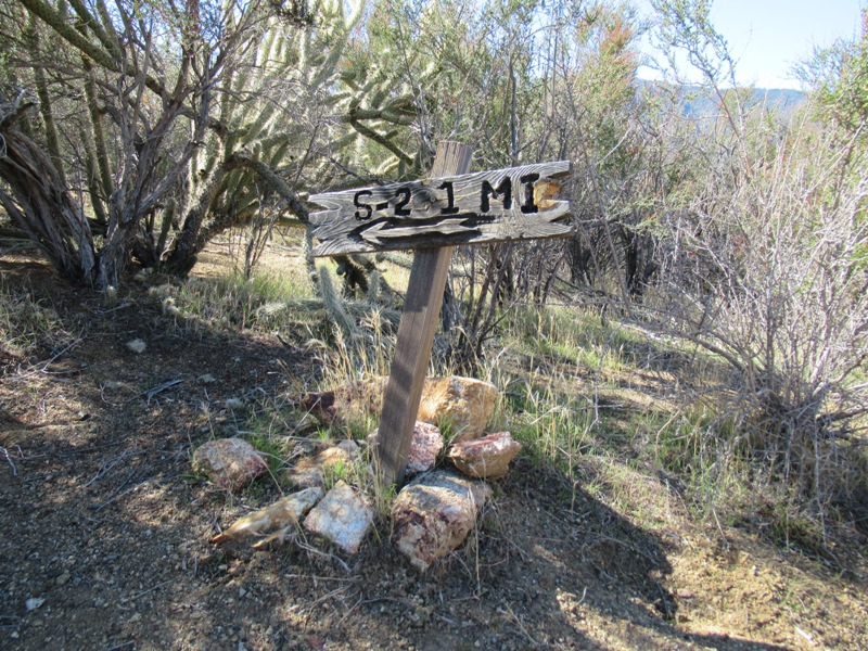
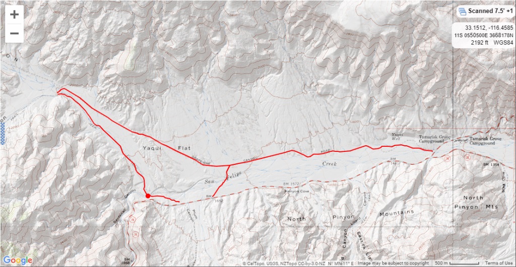
I went out on Saturday to check out accessing the PCT from S2. It starts off on an old jeep trail that disappears at an old water tank and bathtub. I didn't find any real trail from there so I decided to go up the south side of the wash. It was kinda steep, but the footing was solid. The challenge with the south side though (as I found out) is that it leads to a maze of dense vegetation. I could see the trail, but getting there would have been really tricky. As it was, I got a healthy dose of desert pin striping.  I backtracked a bit and dropped down into the wash to cross over to the north side. Once I climbed that ridge it was straightforward to get to the trail. There's a little wooden sign pointing back towards S2. I backtracked a bit and dropped down into the wash to cross over to the north side. Once I climbed that ridge it was straightforward to get to the trail. There's a little wooden sign pointing back towards S2.
I put a few miles on the trail and checked out the water cache further up for thru-hikers. It's impressive, very generous for someone to support the hikers like that. I wanted to follow that dirt road out to see where it met up with Grapevine Canyon, but I was concerned that it was on private property so I turned around. On my return I followed the north ridge all the way back to the old jeep trail.
It was fun to go see a new area, but I think I still prefer accessing that section from Grapevine Canyon. It's away from the road, and just such a cool area.

|
|
|
+1
link
|
|
deborah Posts: 115
1/27/2020
|
Rocko1 wrote:
Cool sign! I want to check out Grapevine Canyon. Do you know if the first mile or so is passable in a 2wd SUV?
From the south end there are a few jeep trails off the 78 that lead to Grapevine Canyon. The jeep trail closest to Tamarisk Grove Campground has a few spots of soft sand. I don't remember the other options being that bad. Once you get past those it's usually easy travel all the way to Angelina Spring. At that point the jeep trail climbs a rocky hill above the spring, then drops back down. That section is probably a bit much for a 2WD.
I was thinking I might head out to that area this weekend. I could check out the conditions and let you know?
|
|
|
+1
link
|
|
deborah Posts: 115
2/3/2020
|
Rocko1 wrote:
If you are already going it would be great to know! Here is where I was planning on going. https://i.imgur.com/ZUqVpw9.png Thank you.
I checked out the jeeps trails at the south end of Grapevine Canyon on Saturday. I drove each of the sections out and back with my truck in 2WD with no problem. On the route that you outlined, the only spot that might be a little tricky is where it crosses the drainage, about a third of a mile in from the 78. It's very shallow, but a little sandy. I could see the sand being an issue at different times during the year, depending on weather and how much traffic it's seen since the last rains. If you go that route, keep up steady momentum as you go through.
The short section just to the east is similar. The section from the S3 was probably the most straightforward, some rollers on the way in but no soft sand when I was there.
I wouldn't think that clearance would be an issue either, but please take a look and see what you think. Getting stuck out there is no fun...


edited by deborah on 2/3/2020
|
|
|
+1
link
|
|
Brian Posts: 225
2/3/2020
|
I used to explore the desert in a Nissan Sentra and took it all sorts of places it had no business going. One thing I always took was an air pump so if I needed to air down to get unstuck, I would have a way to bring it back up before driving on pavement. I took a hand operated floor pump like you would use for a bicycle. It was time consuming to bring up 4 aired down car tires with it, but it does work. The point being that you don't need anything fancy. Just don't go below 10 psi or the bead might separate from the wheel.
|
|
|
+1
link
|
|
Scooter Posts: 114
2/3/2020
|
1979 drove an Opal Cadet from Hwy 78 south on Chariot Canyon and came out Oriflame to S2 !!! Probably should be a new thread.
|
|
|
+1
link
|