|
Brian Posts: 221
2/21/2022
|
I wanted to check out the old Indian trail that goes from Stifferino to the crest (it then continues to Martinez but we didn't do that part).This was a weekend trip with Rocko1. We made good time to the spring on Saturday. Rocko1 would have been able to get to the crest that afternoon, but that would have been too hard for me, so we went with plan A and tackled it Sunday morning.
On Sunday we were on the crest at 9AM and back at the Butler/Rockhouse split at 3:30 driving out. On the way out Rockhouse Canyon we ran into Sicco Rood (I didn't know it was him at the time but I figured it out later). He was there taking pictures and gave us some good information from the time he hiked the crest from Villager to Toro. I think I remember seeing pics from someone here who did a hike to Granite with him on a very windy day.
The spring had much more flow than it did when I was there in November. Still lot of bees.
Rocko1 went ultralight for this trip.

The task ahead.

Rocko1 leading the way up the ridge as the sun comes up.

The view from the top.


edited by Brian on 2/21/2022
|
|
|
+1
link
|
|
Scooter Posts: 111
2/21/2022
|
Wow, I am impressed. Did you see any signs of the old native American trail ? Great trip report. Thanks for sharing
|
|
|
link
|
|
Brian Posts: 221
2/21/2022
|
Scooter wrote:
Wow, I am impressed. Did you see any signs of the old native American trail ? Great trip report. Thanks for sharing
There were definitely sections where the worn trail was obvious and occasional cairns. But it would fade in and out, so we weren't always on it.
I remember you telling me that you looked for the crossing while you were doing a traverse of the crest. I did see a couple cairns at the top that would mark the starting point for descending the ridge to Rockhouse. Didn't think to get a pic of that, unfortunately.
edited by Brian on 2/21/2022
|
|
|
link
|
|
Rocko1 Posts: 588
2/22/2022
|
Was a really interesting trip. I was worried the accent up to the crest would be hard but it was manageable, especially when you are on the native trail. You will know you are off the trail when your speed drops and you start cursing to yourself-the trail really is efficient.
I would be curious to hear from those who have done this route how alternative routes up to Villager/Rabbit via similar spines on the Clark Dry Lake side compare.
Some pics-


|
|
|
link
|
|
dsefcik Administrator Posts: 2609
2/22/2022
|
Nice work you guys..!! Wish I could have joined you. From the routes I have taken on different spines, that was the easy one..!
--
http://www.sefcik.com
http://www.darensefcik.com
http://www.carrizogorge.com
|
|
|
+1
link
|
|
Rocko1 Posts: 588
2/22/2022
|
dsefcik wrote:
Nice work you guys..!! Wish I could have joined you. From the routes I have taken on different spines, that was the easy one..!
Thanks Darren. I felt like this spine was chosen for the right reason. If you could keep the trail the entire way it would really be pretty quick up to the crest. I would say we were on it 30-40% of the time?
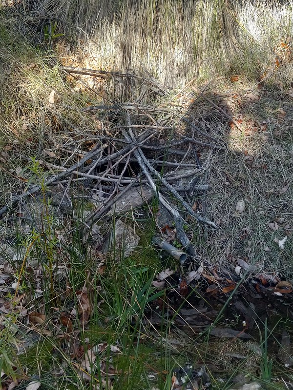
Water from spring had a flavor-wouldn't call it bad, just a smooth texture and aged calcium finish lol. The Nicholas spring was better tasting in my opinion. Spring was producing 3 liters in 7 minutes after we cleared the pipe of debris and mud.
Flow video-https://i.imgur.com/ons8NA2.mp4
.
edited by Rocko1 on 2/22/2022
|
|
|
link
|
|
Buford Posts: 453
2/22/2022
|
Good to see water running good at the spring. Looks like a fun trip.
I would guess that is the easiest ridge up. There is a reason the Native Americans built a trail there.
I have taken a couple ridges up to the Santa Rosa crest, but the trailed one you guys did is not one of them. I have taken up the Villager trail from S22, coming from Mile High via the Rattlesnake the rattlesnake saddle, a ridge from Clark Dry Lake just South of Rabbit, a ridge from Clark Dry Lake just north of Rabbit, the 6582 Schad route and the ridge from the cottonwoods near Nicholias Spring. The only one I would describe as "easy" is the Villager trail from S22.
--
Links to my photos: ABDSP photos, Bighorn sheep photos, ABDSP time lapse video, Wildlife photos (mainly birds)
|
|
|
+1
link
|
|
dsefcik Administrator Posts: 2609
2/23/2022
|
Rocko1 wrote:
Water from spring had a flavor-wouldn't call it bad, just a smooth texture and aged calcium finish lol. The Nicholas spring was better tasting in my opinion. Spring was producing 3 liters in 7 minutes after we cleared the pipe of debris and mud.
Water from Cowboy (aka Stifereno) is not the best tasting, we usually only get water there if we need to, otherwise just pass and get water at the other sources in RHC.
--
http://www.sefcik.com
http://www.darensefcik.com
http://www.carrizogorge.com
|
|
|
+1
link
|
|
rockhopper Posts: 668
2/23/2022
|
Brian wrote:
Scooter wrote:
Wow, I am impressed. Did you see any signs of the old native American trail ? Great trip report. Thanks for sharing
There were definitely sections where the worn trail was obvious and occasional cairns. But it would fade in and out, so we weren't always on it.
I remember you telling me that you looked for the crossing while you were doing a traverse of the crest. I did see a couple cairns at the top that would mark the starting point for descending the ridge to Rockhouse. Didn't think to get a pic of that, unfortunately.
edited by Brian on 2/21/2022
Great trip report! Here is a 1959 map which shows the trail to Martinez creek based on 1927 data but oddly doesn't show the S.R.I.R. I have hiked up from the East a little past the Jack miller cabin several times and hiked up from the S.R.I.R. on the west up the ridge trail but never have completed the middle section but is on my list to do. :-)

|
|
|
+1
link
|
|
Brian Posts: 221
2/23/2022
|
rockhopper wrote:
Great trip report! Here is a 1959 map which shows the trail to Martinez creek based on 1927 data but oddly doesn't show the S.R.I.R. I have hiked up from the East a little past the Jack miller cabin several times and hiked up from the S.R.I.R. on the west up the ridge trail but never have completed the middle section but is on my list to do. :-)
Rocko1 and I were talking about doing a similar thing - doing sections of the trail a little bit at a time rather than all at once. I'd like to do a section starting in Martinez Canyon and going up to the ridge, as you have done. This last one did a number on my feet so I may have to wait until next season to do more.
Which trail are you talking about that goes up from the west? I've driven up to Toro, so I know about the road and the Sawmill trail, but it sounds like you're talking about something else? We were wondering whether the reservation ever gives hikers permission to pass through.
|
|
|
+1
link
|
|
rockhopper Posts: 668
2/23/2022
|
Brian wrote:
rockhopper wrote:
Great trip report! Here is a 1959 map which shows the trail to Martinez creek based on 1927 data but oddly doesn't show the S.R.I.R. I have hiked up from the East a little past the Jack miller cabin several times and hiked up from the S.R.I.R. on the west up the ridge trail but never have completed the middle section but is on my list to do. :-)
Rocko1 and I were talking about doing a similar thing - doing sections of the trail a little bit at a time rather than all at once. I'd like to do a section starting in Martinez Canyon and going up to the ridge, as you have done. This last one did a number on my feet so I may have to wait until next season to do more.
Which trail are you talking about that goes up from the west? I've driven up to Toro, so I know about the road and the Sawmill trail, but it sounds like you're talking about something else? We were wondering whether the reservation ever gives hikers permission to pass through.
From the S.R.I.R side which is the same trail as you did. The reservation has no trespassing signs, so I've never gone in through that way. I have come down heading south from near the old cabin west of Toro peak (Burned down) down into the sawmill valley. The "other sawmill". But I like your idea of doing sections at a time. I am hoping to get out to Martinez canyon. Base camp near Jack Miller cabin and do a day trip up and back from the east side to complete the trail.
|
|
|
link
|
|
Brian Posts: 221
2/23/2022
|
rockhopper wrote:
From the S.R.I.R side which is the same trail as you did. The reservation has no trespassing signs, so I've never gone in through that way. I have come down heading south from near the old cabin west of Toro peak (Burned down) down into the sawmill valley. The "other sawmill". But I like your idea of doing sections at a time. I am hoping to get out to Martinez canyon. Base camp near Jack Miller cabin and do a day trip up and back from the east side to complete the trail.
The only historic maps I have are the ones on CalTopo and they're at a different scale than the one you posted, but I think I understand now the route from the west that you're talking about. I was looking at that on Google Earth one time, trying to decide if it's feasible but I'd never heard of anyone doing it. Nice to know it's possible!
As for the route up from the Jack Miller Cabin, it sounds like you want to do the same section that I do. I misunderstood what you wrote before and thought that was one of the parts you already did. If you'd like a hiking partner for that I'd be interested. But at this point I don't have a good feel for how long it will be until my feet can handle a serious hike. Last time I had foot pain like this it took several months to resolve.
|
|
|
link
|