|
desertman Posts: 2
5/1/2009
|
I have hiked to Goat canyon Trestle along the tracks from Dos Cabezas. This was long but pretty easy. Has anyone taken this route recently?
surfpontoi wrote:
Not really any easy way. Probably the best way would be from Mortero Palms but that is a grueling hike.
edited by surfpontoi on 4/28/2009
|
|
|
link
|
|
jt Posts: 1
5/3/2009
|
Friends hiked along the tracks (illegal, we should point out, because on railroad property) in Dec 07. It's the easiest way to get to the Trestle, but still quite a decent hike. See Jerry Schad's Indian Hill hike in Afoot and Afield--cut across the desert east from end of the road past Dos Cabezas. This cuts off the big northerly loop the tracks take.
|
|
|
link
|
|
surfponto Administrator Posts: 1369
5/3/2009
|
Thanks JT.
Haven't done thatr route yet.
Will have to check that out. Is that the one that takes you past Carrizo Palms?
Bob
jt wrote:
Friends hiked along the tracks (illegal, we should point out, because on railroad property) in Dec 07. It's the easiest way to get to the Trestle, but still quite a decent hike. See Jerry Schad's Indian Hill hike in Afoot and Afield--cut across the desert east from end of the road past Dos Cabezas. This cuts off the big northerly loop the tracks take.
--
https://www.anzaborrego.net/


|
|
|
link
|
|
surfponto Administrator Posts: 1369
2/8/2010
|
Hey again,
We did the Mortero Palms route and it was easy to follow with a GPX track I downloaded. Pretty amazing hike.
Probably do it again this year during the Spring.
Goat Canyon Trestle Revisited
Bob
jt wrote:
Friends hiked along the tracks (illegal, we should point out, because on railroad property) in Dec 07. It's the easiest way to get to the Trestle, but still quite a decent hike. See Jerry Schad's Indian Hill hike in Afoot and Afield--cut across the desert east from end of the road past Dos Cabezas. This cuts off the big northerly loop the tracks take.
<em>edited by surfponto on 2/8/2010</em>
--
https://www.anzaborrego.net/
|
|
|
link
|
|
dsefcik Administrator Posts: 2634
4/20/2010
|
We tried to get to the trestle and were very close. We started at Sacatone Overlook, see details of the trip here:
http://www.sefcik.com/index.php/2010/04/19/sacatone-overlook-to-goat-canyon-hike

Daren
<em>edited by dsefcik on 4/21/2010</em>
--
http://www.sefcik.com
http://www.darensefcik.com
http://www.carrizogorge.com
|
|
|
link
|
|
hikerdmb Posts: 423
4/21/2010
|
Daren,
That looks like a long and rugged hike through some pretty incredible terrain. However when I click on your link I get a blank page. Can you check that? I would like to see more details about this trip.
David
|
|
|
link
|
|
dsefcik Administrator Posts: 2634
4/21/2010
|
hikerdmb wrote:
Daren,
That looks like a long and rugged hike through some pretty incredible terrain. However when I click on your link I get a blank page. Can you check that? I would like to see more details about this trip.
David
Maybe I just messed up the url tag, I edited it and seems to work now. If not just copy/paste this url into your browser
http://www.sefcik.com/index.php/2010/04/19/sacatone-overlook-to-goat-canyon-hike
--
http://www.sefcik.com
http://www.darensefcik.com
http://www.carrizogorge.com
|
|
|
link
|
|
surfponto Administrator Posts: 1369
4/21/2010
|
Hey Daren,
The link works for me.
Those rattlesnake pictures are great!
Looks like you were pretty close unless you had a good zoom lens 
I actually just got back from Dos Cabezas. I had planned to solo hike from Mortero Palms to the Trestle but the weather kind of messsed up my plans.
When I opened the door of my landCruiser the wind almost blew it off.... :-0
There were also the occasional rain squalls blowing over the mountains so I decided to leave it for another day.
Bob
dsefcik wrote:
hikerdmb wrote:
Daren,
That looks like a long and rugged hike through some pretty incredible terrain. However when I click on your link I get a blank page. Can you check that? I would like to see more details about this trip.
David
Maybe I just messed up the url tag, I edited it and seems to work now. If not just copy/paste this url into your browser
http://www.sefcik.com/index.php/2010/04/19/sacatone-overlook-to-goat-canyon-hike
<em>edited by surfponto on 4/21/2010</em>
--
https://www.anzaborrego.net/
|
|
|
link
|
|
hikerdmb Posts: 423
4/21/2010
|
Daren,
It worked for me too. NIce trip. I left you a comment on the site.
David
|
|
|
link
|
|
dsefcik Administrator Posts: 2634
4/22/2010
|
hikerdmb wrote:
Daren,
It worked for me too. NIce trip. I left you a comment on the site.
David
Thanks, I replied back..
There are so many possible hiking routes out there. I will put together a few more and post them to see if there is any interest.
Daren
--
http://www.sefcik.com
http://www.darensefcik.com
http://www.carrizogorge.com
|
|
|
link
|
|
dsefcik Administrator Posts: 2634
4/22/2010
|
surfponto wrote:
Hey Daren,
The link works for me.
Those rattlesnake pictures are great!
Looks like you were pretty close unless you had a good zoom lens
I actually just got back from Dos Cabezas. I had planned to solo hike from Mortero Palms to the Trestle but the weather kind of messsed up my plans.
When I opened the door of my landCruiser the wind almost blew it off.... :-0
There were also the occasional rain squalls blowing over the mountains so I decided to leave it for another day.
Bob
I was within a few feet of both them but I ran as soon as I heard them rattle. Scott stepped up and took the pictures, he had a zoom camera and stayed a good 15' feet or so back. The canyon that leads up to the trestle has a very steep rock face at the bottom, almost dry fall'ish like. You can see it in Google Earth, barely. There is another way or two up from the gorge. I will draw up a few maps and post them to see if anybody is interested in trying them.
Daren
--
http://www.sefcik.com
http://www.darensefcik.com
http://www.carrizogorge.com
|
|
|
link
|
|
surfponto Administrator Posts: 1369
4/22/2010
|
That would be awesome if you could post those.
My wife and I are talking about heading out next Thursday to hike in from Carrizo Gorge
True the Google Earth images can be misleading. :-)
Bob
dsefcik wrote:
surfponto wrote:
Hey Daren,
The link works for me.
Those rattlesnake pictures are great!
Looks like you were pretty close unless you had a good zoom lens
I actually just got back from Dos Cabezas. I had planned to solo hike from Mortero Palms to the Trestle but the weather kind of messsed up my plans.
When I opened the door of my landCruiser the wind almost blew it off.... :-0
There were also the occasional rain squalls blowing over the mountains so I decided to leave it for another day.
Bob
I was within a few feet of both them but I ran as soon as I heard them rattle. Scott stepped up and took the pictures, he had a zoom camera and stayed a good 15' feet or so back. The canyon that leads up to the trestle has a very steep rock face at the bottom, almost dry fall'ish like. You can see it in Google Earth, barely. There is another way or two up from the gorge. I will draw up a few maps and post them to see if anybody is interested in trying them.
Daren
--
https://www.anzaborrego.net/
|
|
|
link
|
|
dsefcik Administrator Posts: 2634
4/23/2010
|
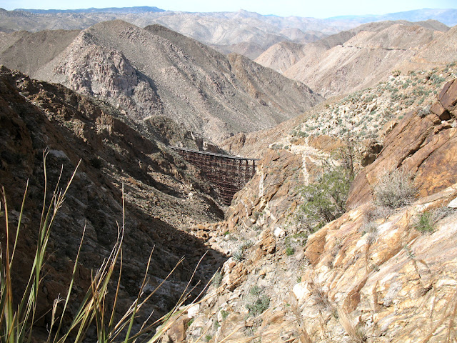
So just from the last 4 times I hiked this similar route I think this is doable given:
1. You are willing to hike some portion on the tracks
2. You will be hiking all day
3. It wont be easy, there are no trails other than animal paths and maybe my footprints from a couple of weeks ago
4. If you drive from San Diego you save lots of driving time by getting off at Boulevard instead of heading out to the S2
You can see from image #2 that from Mortero Palms this route is not the shortest.
I can post a Garmin gdb,generic gpx or google earth kmz if you want..in fact I wouldn't mind trying this route. If you go and want company let me know.
Daren


--
http://www.sefcik.com
http://www.darensefcik.com
http://www.carrizogorge.com
|
|
|
link
|
|
surfponto Administrator Posts: 1369
4/24/2010
|
That is awesome.
Really puts the whole thing in perspective. Not sure my wife would want to do the hike from Sacatone overlook.
I convinced her we can do it from the South end of Carrizo Gorge and I am anticipating about 3 miles one way from where we park.
I am going to do a better job setting waypoints this time since on our last attempt a couple years ago we got a bit lost.
Carrizo Gorge To Goat Canyon
We are thinking leaving early Thursday if nothing comes up at work before then. You are welcome to join us.
<em>edited by surfponto on 4/24/2010</em>
--
https://www.anzaborrego.net/
|
|
|
link
|
|
surfponto Administrator Posts: 1369
4/24/2010
|
Meant to ask. Is that the standard Google earth you are using? It looks better than mine
--
https://www.anzaborrego.net/
|
|
|
link
|
|
dsefcik Administrator Posts: 2634
4/24/2010
|
surfponto wrote:
That is awesome.
Really puts the whole thing in perspective. Not sure my wife would want to do the hike from Sacatone overlook.
I convinced her we can do it from the South end of Carrizo Gorge and I am anticipating about 3 miles one way from where we park.
I am going to do a better job setting waypoints this time since on our last attempt a couple years ago we got a bit lost.
Carrizo Gorge To Goat Canyon
We are thinking leaving early Thursday if nothing comes up at work before then. You are welcome to join us.
edited by surfponto on 4/24/2010
I would love to go but need to see what happens Tuesday first, I would need to be back in Point Loma by 5pm.
Do you have a route of where you plan to hike thru the gorge? I will say that the canyon up to the trestle will be tough, at least the first part as it looks like a steep dry fall or cliff at the beginning. The ridge to north may be the best way, that is what stonewell's group did. In fact if you read the post you will see they ascended the utility road just south of where my map shows going up the ridge. They then walked the tracks thru the long tunnel and then the short tunnel to get the trestle. My map takes the utility rd around the long tunnel.
See the maps below for what I am talking about.


--
http://www.sefcik.com
http://www.darensefcik.com
http://www.carrizogorge.com
|
|
|
link
|
|
dsefcik Administrator Posts: 2634
4/24/2010
|
surfponto wrote:
Meant to ask. Is that the standard Google earth you are using? It looks better than mine
Google Earth
5.1.3509.4636 (beta)
Build Date
Sep 17, 2009
Build Time
3:18:34 pm
Renderer
OpenGL
Operating System
Linux (2.6.31.0)
Video Driver
ATI Technologies Inc.
Max Texture Size
8192x8192
Server
kh.google.com
--
http://www.sefcik.com
http://www.darensefcik.com
http://www.carrizogorge.com
|
|
|
link
|
|
surfponto Administrator Posts: 1369
4/24/2010
|
Thanks,
I like that idea of using the utility road. I have heard about the dry waterfalla t the mouth of Goat Canyon. I head it is hard but not insurmountable.
Your maps have been very helpful.
I honestly don't know how much time to allow for this?
We wanted to get an early start but that means leaving Leucadia araound 7AM.
Bob
--
https://www.anzaborrego.net/
|
|
|
link
|
|
dsefcik Administrator Posts: 2634
4/24/2010
|
surfponto wrote:
I honestly don't know how much time to allow for this?
Bob
We were moving about .5-.75mph thru the gorge, it was slow moving. Once you start the climb up to the trestle it will be even slower. We just had a hard time picking a route, there was so much brush and rock. I don't know what the gorge looks like north of Goat Canyon so you can make a determination based on your last trip I am sure.
Daren
--
http://www.sefcik.com
http://www.darensefcik.com
http://www.carrizogorge.com
|
|
|
link
|
|
dsefcik Administrator Posts: 2634
4/24/2010
|
surfponto wrote:
That is awesome.
I convinced her we can do it from the North end of Carrizo Gorge and I am anticipating about 3 miles one way from where we park.
edited by surfponto on 4/24/2010
Do you mean the "north" end? If the south, where are you parking?
<em>edited by surfponto on 4/24/2010</em>
--
http://www.sefcik.com
http://www.darensefcik.com
http://www.carrizogorge.com
|
|
|
link
|
|
surfponto Administrator Posts: 1369
4/24/2010
|
Sorry you are correct. I meant the north end.
We drive up Carrizo Gorge from the S2
I can get as far as the creek drop off in my LandCruiser
Bob
dsefcik wrote:
surfponto wrote:
That is awesome.
I convinced her we can do it from the South end of Carrizo Gorge and I am anticipating about 3 miles one way from where we park.
edited by surfponto on 4/24/2010
Do you mean the "north" end? If the south, where are you parking?
--
https://www.anzaborrego.net/
|
|
|
link
|
|
surfponto Administrator Posts: 1369
5/2/2010
|
Great hike yesterday Daren,
I am still picking cholla spines out of my %$#@
I will post up some pics and a trip report soon.
Bob
dsefcik wrote:
surfponto wrote:
That is awesome.
I convinced her we can do it from the North end of Carrizo Gorge and I am anticipating about 3 miles one way from where we park.
edited by surfponto on 4/24/2010
Do you mean the "north" end? If the south, where are you parking?
edited by surfponto on 4/24/2010
--
https://www.anzaborrego.net/
|
|
|
link
|
|
surfponto Administrator Posts: 1369
5/3/2010
|
Here are the pics I have so far.
Goat Canyon Trestle Hike Photos
I have a couple more truck ones I can send you also.
Bob
--
https://www.anzaborrego.net/
|
|
|
link
|
|
dsefcik Administrator Posts: 2634
5/4/2010
|
I would like to see more pics of the truck, thanks..
surfponto wrote:
Here are the pics I have so far.
Goat Canyon Trestle Hike Photos
I have a couple more truck ones I can send you also.
Bob
--
http://www.sefcik.com
http://www.darensefcik.com
http://www.carrizogorge.com
|
|
|
link
|
|
dsefcik Administrator Posts: 2634
5/4/2010
|
I have a few also, probably similar to yours:
http://www.sefcik.com/index.php/photo-gallery/carrizo-gorge-to-goat-canyon-trestle-05-01-2010/
Daren
surfponto wrote:
Here are the pics I have so far.
Goat Canyon Trestle Hike Photos
Bob
--
http://www.sefcik.com
http://www.darensefcik.com
http://www.carrizogorge.com
|
|
|
link
|
|
tahosin39 Posts: 1
9/28/2011
|
Pictures, prints and onto canvas created from your own photos, framed and ready to hang. For the best quality canvas prints at the lowest online prices guaranteed, with fast delivery.
http://www.picstocanvas.co.uk
Pictures printed onto canvas
|
|
|
link
|