|
RobertMarcos Posts: 23
12/23/2016
|
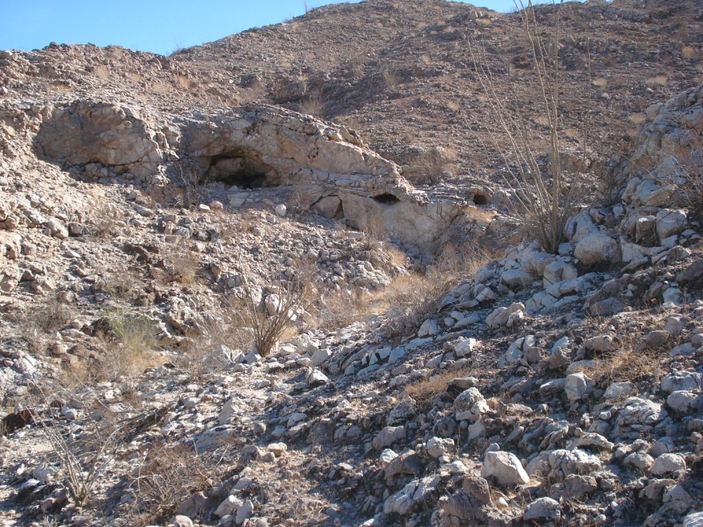
Earlier this year I had a terrific hike to a place that I found on Google Earth. I found it while I was scouring the desert floor searching for the lost Spanish pearl ship of Juan De Iturbe. (see photo #1)
Instead of the 400-year old ship I found a lovely palm oasis tucked in a small canyon about four miles west of Travertine Point. Travertine Point is a prominent hill covered with coral and graffiti. It’s at the intersection of Highway 86 and 86th Avenue - a mile north of the town of Desert Shores, just west of the Salton Sea. (See photo #2)
My first attempt to reach the hidden oasis was in April 2016. The weather was borderline hot, about 90-degrees by midday. I got a late start that day and didn’t arrive until about 3 pm. I turned off highway 86 at 86th Avenue and parked my car in the dirt. I got my mountain bike out and rode a mile down the dirt road past two huge vineyards. At that point you can see the small mountain range about 3 miles to your left, (south). I rode at most another mile before the packed sand turned to small boulders, and then into large boulders. I hid my bike, (too well as it turned out because it took me 40-minutes to find it afterward), then took off on foot.
I personally have never had a problem with coyotes, but that day I got really spooked because at about 5pm about twenty of them started howling, and the packs seemed to surround me. I couldn’t see any of them but being out by yourself, without any protection whatsoever, while the sun is sinking…etc., etc. I called it a day.
We had a cool snap about two weeks later and I arrived much earlier. This time I left my bike and parked beside a power substation in Coolidge Springs. I set off on foot towards the southern boundary of the vineyard. Their fence ends at the hillside so you can hike around it. Note - very likely you’ll be trespassing at this point. But by hiking along the vineyard’s southern border you’ll make double time, as opposed to hiking over the mountains to the oasis.
I don’t have a GPS so I used a compass to follow headings that I’d written out in advance. It took me about two hours to reach the palm oasis, and it was worth it. There was evidence of Native American use - a large fire ring and several large shards of pottery laying in plain sight. The only evidence of a “non-native” visitor was the initials “JD” and the date “January 1941” carved on a round stone along the trail.
Now here’s the great part. On the way out I found what appeared to be an ancient indian trail. When I say “ancient” I mean that the stones laying on the narrow trail had a heavy brown patina, (desert varnish), and shrubs had grown over parts of the trail. Not a single rock had been overturned for maybe 300 years. (When I make an estimate like that its based on archaeological research I read. Scientists had carbon dated the remains of a cooked fish that they uncovered in a fire ring near the shoreline of Ancient Lake Cahuilla. The test showed that the fish had been cooked in 1740, plus or minus 30 years. After that the ancient lake completely dried up, and the indians didn't catch any more fish until the Trader Joes opened in 2014.
Anyway the old indian trail carried me most of the way back with barely any trespassing required. Walking along that trail, the sun low on the horizon, I felt a historic connection to the ancient people and to the mountains they inhabited.
edited by RobertMarcos on 12/23/2016
edited by RobertMarcos on 12/23/2016
|
|
|
link
|
|
ziphius Posts: 911
12/24/2016
|
Nice trip. Also known as 'Travertine Palms'. From Diana Lindsay's book, Anza-Borrego A to Z: "Travertine Palms had been used by Cahuilla Indians as a resting place along a trail leading into the Santa Rosa Mountains from the Coachella Valley. Fig Tree John, a Cahuilla Indian recluse, was said to have used the oasis while working his alleged gold mine located somewhere nearby."
Any signs of surface water at the palms? - Jim
edited by ziphius on 12/24/2016
--
http://www.coyotelearning.org
|
|
|
+1
link
|
|
RobertMarcos Posts: 23
12/24/2016
|
Hi Jim - I'm very sorry to learn that I didn't discover that place, dang it. There's no sign of water there, or anywhere else in that small range. And it does very much resemble an "overnight rest stop" as opposed to a long-term habitat. There's LOTS of old trails and sleeping circles but very few pottery shards and no morteros, petroglyphs, or old bones leftover from dinner. I assume that when the Ancient Lake Cahuilla dried up the natives had to abandon the area altogether.
|
|
|
link
|
|
RobertMarcos Posts: 23
12/24/2016
|
I just saw Rockhopper's (much better) article about this same place. It's called Travertine Palms. He has great photos...
http://www.anzaborrego.net/AnzaBorrego/forum/topic455-travertine-palms-oasis-and-caves.aspx
|
|
|
link
|
|
rockhopper Posts: 678
12/24/2016
|
Thanks Robert,
It is a fantastic area out there. I would like to return sometime in Spring 2017 to the caves about a mile from the Travertine oasis. Any takers?
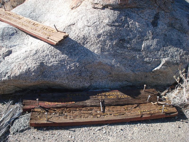
Btw , way the sign still there?
edited by rockhopper on 12/24/2016
|
|
|
link
|
|
ziphius Posts: 911
12/24/2016
|
rockhopper wrote:
It is a fantastic area out there. I would like to return sometime in Spring 2017 to the caves about a mile from the Travertine oasis. Any takers?
I would gladly participate in that adventure. - Jim
--
http://www.coyotelearning.org
|
|
|
link
|
|
RobertMarcos Posts: 23
12/24/2016
|
I would love to participate...thank you.
|
|
|
link
|
|
rockhopper Posts: 678
12/24/2016
|
ziphius wrote:
Nice trip. Also known as 'Travertine Palms'. From Diana Lindsay's book, Anza-Borrego A to Z: "Travertine Palms had been used by Cahuilla Indians as a resting place along a trail leading into the Santa Rosa Mountains from the Coachella Valley. Fig Tree John, a Cahuilla Indian recluse, was said to have used the oasis while working his alleged gold mine located somewhere nearby."
Any signs of surface water at the palms? - Jim
edited by ziphius on 12/24/2016
Thanks for the reminder about "Fig Tree John" Absolutely fantastic reading of this desert icon. He likely traveled every canyon for 100 miles around his homestead/spring/fig farm. He had to move when the Salton sea was filling in 1905. Many that knew him claimed he lived over 100. His son claimed he lived to 136. I need to eat more figs!!!!
btw if you google " Fig tree john gold map" his gold mine looks around Nicolas canyon area??
|
|
|
link
|
|
dsefcik Administrator Posts: 2634
12/26/2016
|
rockhopper wrote:
Btw , way the sign still there?
It was there last November 2015, we stopped by Travertine on our way out of Martinez.

edited by dsefcik on 12/26/2016
--
http://www.sefcik.com
http://www.darensefcik.com
http://www.carrizogorge.com
|
|
|
link
|
|
dsefcik Administrator Posts: 2634
12/26/2016
|
RobertMarcos wrote:
Now here’s the great part. On the way out I found what appeared to be an ancient indian trail. When I say “ancient” I mean that the stones laying on the narrow trail had a heavy brown patina, (desert varnish), and shrubs had grown over parts of the trail. Not a single rock had been overturned for maybe 300 years. (When I make an estimate like that its based on archaeological research I read. Scientists had carbon dated the remains of a cooked fish that they uncovered in a fire ring near the shoreline of Ancient Lake Cahuilla. The test showed that the fish had been cooked in 1740, plus or minus 30 years. After that the ancient lake completely dried up, and the indians didn't catch any more fish until the Trader Joes opened in 2014.
This is the trail I remember when I was out there

--
http://www.sefcik.com
http://www.darensefcik.com
http://www.carrizogorge.com
|
|
|
+1
link
|
|
RobertMarcos Posts: 23
12/26/2016
|
No, I did not see that sign. And I had a very "investigative" visit, like Columbo arriving at a crime scene...except without the cigar.
dsefcik wrote:
rockhopper wrote:
Btw , way the sign still there?
It was there last November 2015, we stopped by Travertine on our way out of Martinez.
edited by dsefcik on 12/26/2016
|
|
|
link
|
|
rockhopper Posts: 678
1/2/2017
|
Regarding return trip: Sure, Robert and Ziphius if the stars align and we can all make it happen that's great. I am thinking Feb/March time for more daylite. Best scenario would camp near Coolage springs and leave early the next morning for a all day hike. So basically car camp/ day pack trip and return home at night, or stay an extra day? Now if I can just find those caves again.....
Cheers and Happy New Year
Rockhopper
|
|
|
link
|