|
mrkmc Posts: 87
2/27/2012
|
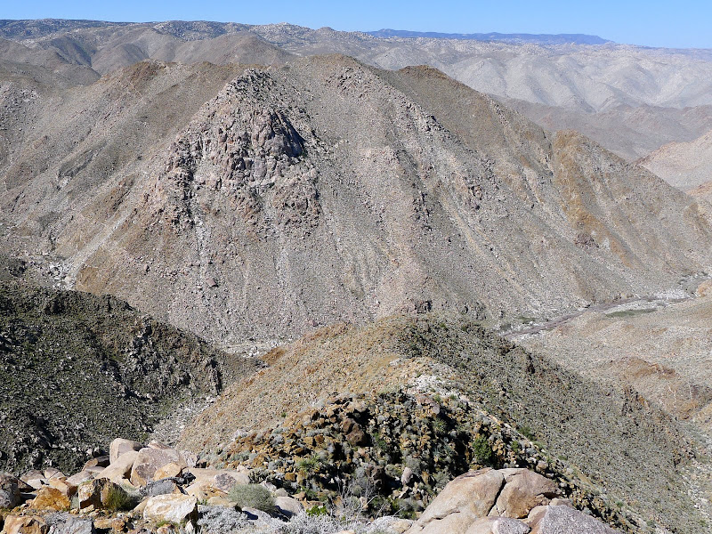
I found this website and forum while looking for information about the Carrizo Creek jeep trail. I was planning a hike in the area and wanted to use the road as an exit point. After receiving some good information from people on this forum, I finally got a around to giving the route a try this weekend. We started up the jeep trail a little after 5:30AM and left a 4x4 at the end road. We then took my truck back out to the highway then drove over to Dos Cabezas Road via Mortero Wash. Six of us set off for Indian Hill at about 7:40AM. After a quick visit to the highpoint of Indian Hill we headed for Moan benchmark. The scramble up the east slope was a lot of fun and some of the boulders have interesting shapes and features.

Boulder near Moan BM
After a short break at the Moan benchmark we headed south, passing bump 3053 on the west. About a mile later we started traversing a steep slope, descending slightly until we were just below the Puff benchmark. The slope was loose, steep and covered in cactus. As we worked our way through this tedious section I could hear the others cursing the cactus. While enjoying the views of the railroad trestles from Puff a military helicopter came flying down the gorge a few hundred feet above the railroad.

Trestle from Puff BM

Helicopter from Puff BM
From Puff we descended the west ridge down to the gorge. Coming down the ridge we got a good look at the slope we would need to climb to reach Groan benchmark. There is a tricky section along the ridge were a steep back cut was made for an access road. Once we down climbed the road cut, we continued down the cactus covered ridge to the bottom of the gorge where we rested in the shade of a large boulder and picked the cactus needles from our skin.
Looking across the gorge from the Puff Ridge at Groan

Looking up toward Groan from Carizzo Gorge
We forced our way across the brushy canyon bottom and started the steep climb to Groan. We climbed about 1200' in just over half a mile to reach the ridge! The area to the right of the giant rock out cropping was in the shade so we scrambled up the boulders and slabs at the base of the out cropping rather than slog up the slope in the sun. It took about 1.5 hours to reach the saddle, where we got another great view of the Goat Canyon trestle.

Goat Canyon Trestle with the Puff Ridge on the left from saddle near Groan BM
After regrouping at the saddle we walked over to the benchmark and took another break. By this point everyone had shed some bled. The cacti in this area are large and healthy! 2 people in the group had enough of the constant stabbings and decided to head off the north west ridge of Groan and follow the drainage to the vehicle at the end of the jeep trail. The rest of us dropped down to the saddle south west of Groan then began a gradual descending traverse to the drainage below the east ridge of Gasp. The climb up to Gasp benchmark was tough and required about 1400' of gain, but at least the north side of the ridge was in the shade. We were disappointed when we got to bump 2993, thinking it was Gasp. From there we had to give up a few hundred feet before continuing up the ridge towards Gasp.

Gasp as seen from bump 2993
It was a little after 4pm when we reached Gasp. By this point everyone was getting tired and a few of us were low on water and food. The original plan was to include the Grunt benchmark in the hike but we had enough for the day and decided follow the north ridge down to Carrizo Canyon. The ridge descent wasn't that bad because the sun had fallen behind the mountains and there was a nice cool wind. After dropping off the ridge we came across a use trail in the canyon bottom which we followed a short distance back to the waiting vehicle. With 6 people crammed into a small Suzuki 4x4, we headed for the highway and back to Dos Cabezas to retrieve the other cars. I want to give this hike another try, but skip Indian Hill and start an hour or so earlier. I think that would make adding Grunt a little easier.
Here are more pictures from the hike.
<em>edited by mrkmc on 2/28/2012</em>
|
|
|
link
|
|
surfponto Administrator Posts: 1369
2/27/2012
|
Awesome trip report and some really good pictures on your Google+ site.
I like all the artifacts you found like that cool old shovel blade.
thanks for posting this. makes me want to try your route. 
Bob
--
https://www.anzaborrego.net/


|
|
|
link
|
|
dsefcik Administrator Posts: 2634
2/27/2012
|
Great views of the trestle! Groan had to be bitch, I have come down a few times just south of it and I always look up at it thinking it is way too steep. Great TR and maybe I can make it out next time with you guys, it just didn't work out for me this weekend.
Daren
--
http://www.sefcik.com
http://www.darensefcik.com
http://www.carrizogorge.com
|
|
|
link
|
|
ziphius Posts: 911
2/27/2012
|
I like it! Your gang is hard-core off-trail zany. Great pics. - Jim
--
http://www.coyotelearning.org
|
|
|
link
|
|
anutami Posts: 491
2/27/2012
|
Congrats on your finale of sd peaks. What a final destination! You went more remote than the bighorn sheep dare to go. What next?
|
|
|
link
|
|
hikerdmb Posts: 423
2/28/2012
|
They gave those benchmarks the right names. Great pics!
|
|
|
link
|
|
mrkmc Posts: 87
2/28/2012
|
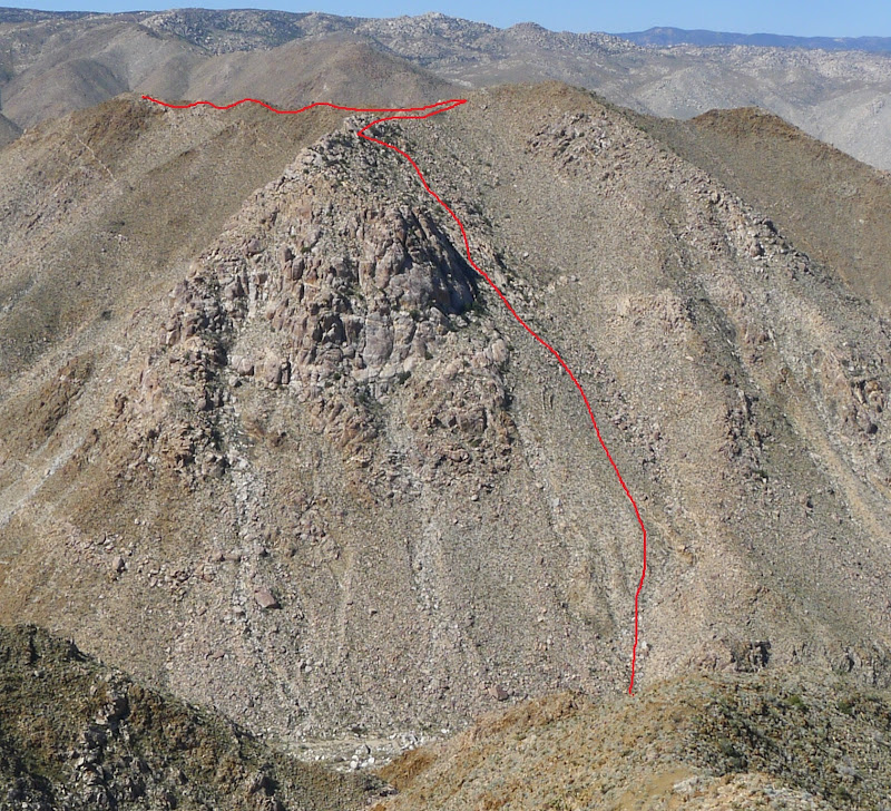
Bob, those old shovels were neat. I like how bent they were. I cant imagine how hard it must have been to be shoveling rock on the side of the canyon wall in the heat of summer! Daren, yes, going up Groan was tough. I considered climbing the slope directly below Groan. It looks a little better than the way we went, but getting there would mean traveling about 3/4 of a mile through the catclaw choked canyon. No thanks! The approximate route is drawn on the pic below. Thanks anutami, not really a finale, the park is so big I dont think you can every really be done exploring it.
|
|
|
link
|
|
mrkmc Posts: 87
2/28/2012
|
Also, here is a video clip of the helicopter flying through the canyon. We saw the same helicopter at the end of the day flying back up the canyon.
|
|
|
link
|
|
surfponto Administrator Posts: 1369
2/28/2012
|
Must be Border Patrol
According to Daren they use the military copters.
mrkmc wrote:
Also, here is a video clip of the helicopter flying through the canyon. We saw the same helicopter at the end of the day flying back up the canyon.
--
https://www.anzaborrego.net/
|
|
|
link
|
|
dsefcik Administrator Posts: 2634
2/28/2012
|
surfponto wrote:
Must be Border Patrol
According to Daren they use the military copters.
They have un-permitted sensors in the gorge and it is possible you tripped one, I know it seems like almost every time we are down in the gorge they fly overhead.
This is from the last time we dropped down in from Sacatone

--
http://www.sefcik.com
http://www.darensefcik.com
http://www.carrizogorge.com
|
|
|
link
|