|
herofix Posts: 30
3/21/2012
|
About a month ago on President's Day I took a drive out of Escondido heading for ABDSP to check out a few hikes in the Lindsay guidebook. On the way there I stopped off at the San Felipe Valley Wildlife Area to "see what I could see". As it turned out, the answer was "not much", though I did enjoy the wide-open feel of the trail and serene silence found just a few hundred yards off S-2. I didn't see much wildlife, though...at least not directly.
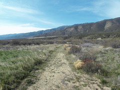
Views from the trailhead:


The trail looks like an old ranch road, though I believe it may be part of the California Hiking and Riding Trail:
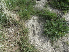
Like I said, I didn't directly observe any wildlife, though I did find this track, which I thought might be from a mountain lion:
Granite Mountain had some snow on its shoulders from the storm that had blown through that weekend:

Next I headed down 78 toward Ocotillo Wells. Passing through the Sentenac Cienega area, I paused to look for the remains of the stone cabin mentioned in the Lindsay book. Has anyone ever checked it out? I couldn’t see anything from the road and don’t know if there’s a trail nearby.

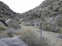
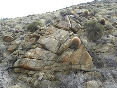
I proceeded down canyon until I turned off at the Plum Canyon sign and proceeded up the dirt road about two miles, taking the right fork to what I *thought* was the trailhead:
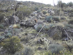
I now realize that the "short hike to a viewpoint overlooking Earthquake Valley" may have been at the end of the *left* fork. I swear I must have hiked 2+ miles (my definition of a "short hike") and didn't find any such viewpoint. Anybody know for sure? It was a great hike anyway, as I had the trail to myself. There are also numerous rock formations, dry waterfalls and other interesting stuff to look at:

After that excursion I wasn’t quite worn out and wanted to see more, since I don't get out that way very often. I headed down Yaqui Pass Road and parked by the closed Tamarisk Grove campground. Anyone know why it is closed? I'm guessing state budget cuts.
Some friendly fellow hikers offered me the last copy of the trail pamphlet, so I headed out on the short Yaqui Well trail. After a pleasant but uneventful stroll, I arrived at Yaqui Well. Even in late February I would have expected it to have some visible water, but as you can see it was largely dry. There were quite a few bees or wasps flying into the vegetation, so I would bet there was still some water down there somewhere:

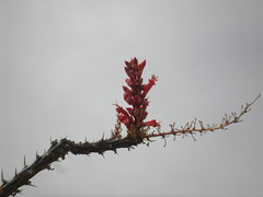
On the way back I passed a few ocotillo with buds just starting to bloom:
All in all, it was a good trip, though I didn't see exactly what I was expecting. Passing through Julian on the way home I picked up an Apple Boysenberry pie at Mom's, and that always helps make a successful excursion.
<em>edited by herofix on 5/9/2012</em>
|
|
|
link
|
|
dsefcik Administrator Posts: 2634
3/21/2012
|
Nice TR..thanks for sharing. While most of the time I (and others) always seem to focus on the "big" hikes or trips, we never stop to check out the smaller ones. All those places you went I have driven by a million times and said "I need to go check out Plum Cyn" or the Yaqui trail. Maybe over break I will spend a day stopping at some of those.
BTW, the PCTA and ABDSP have purchased more land for the park http://www.eastcountymagazine.org/node/9082
Daren
--
http://www.sefcik.com
http://www.darensefcik.com
http://www.carrizogorge.com
|
|
|
link
|
|
mrkmc Posts: 87
3/21/2012
|
herofix wrote:
I now realize that the "short hike to a viewpoint overlooking Earthquake Valley" may have been at the end of the *left* fork. I swear I must have hiked 2+ miles (my definition of a "short hike") and didn't find any such viewpoint. Anybody know for sure? I
I believe you were on the correct trail. I hiked to Sentenac Mountain a few months ago from the west fork of Plum Canyon. I started from the end of the right fork (looks like what you have in your picture) and followed the trail/wash. I left the trail and headed directly for Sentenac, but the trail continued on toward the saddle. See this map, the black line is the approx trail, red line is where I went. It was only 1.25 miles to Sentenac, so its only about 1 mile to the view point.
<em>edited by mrkmc on 3/21/2012</em>
|
|
|
link
|
|
herofix Posts: 30
3/22/2012
|
Interesting, thanks for the topo view. The whole time I was hiking I kept thinking "it must be just around the bend", but the path stayed down in the wash and never rose or opened up to any viewpoint. I guess I just didn't go far enough, but it sure seemed like it...
By the way, how did you map out your route and distance? Is a GPS required for that, or can you use a pedometer or similar device? I'd love to know how far I go each time.
Thanks.
|
|
|
link
|
|
dsefcik Administrator Posts: 2634
3/22/2012
|
herofix wrote:
By the way, how did you map out your route and distance? Is a GPS required for that, or can you use a pedometer or similar device? I'd love to know how far I go each time.
Thanks.
Most people will use a GPS but if you have an iPhone or one of the Android phones you can use an app to do all of your GPS/Mileage tracking.
--
http://www.sefcik.com
http://www.darensefcik.com
http://www.carrizogorge.com
|
|
|
link
|
|
mrkmc Posts: 87
3/22/2012
|
What Darren said. I didn't have my gps the day I did that hike, but you can estimate mileage and gain using National geographic Topo! or for free you can use caltopo.com (including the map posted above) you can right click on the map and select measure, then distance. Keep clicking along a line from start to finish and it will tell you the total mileage.
|
|
|
link
|