|
dsefcik Administrator Posts: 2634
6/20/2012
|
No big tortuous hike or backpacking trip, not even a crazy whiskey induced campfire story....just some side trip photos from driving out to the annual BHS count orientation meeting. Drove out last Friday after work and pulled off the highway to try and find the "second" old shack near Myer Valley. Very quickly I needed to switch into 4WD Low to pass thru the dry creek and up a few sketchy sections before seeing the BLM sign indicating no vehicles were allowed beyond that point. Being the do-gooder that I am I decided to turn around and not break any laws, I really didn't have to time to go hiking for hours, it was already around 5pm....but I had to pee first before leaving. As I got out and started my business I looked down and saw some pottery sherds..OK, time to look around.
I grabbed my camera and a 32oz bottle of water and also left a few bottles of water outside my truck for anyone who might just be "passing by" and started walking. It did not take more than 15 minutes before Border Patrol agents were walking towards me. We chatted a bit and they indicated that the area was very active, typically apprehending several people each day and night. I started poking around and found some interesting items but nothing earth shattering so sorry if this post bores you....
Some large pottery sherds

This old glass bottle had some vintage purple tint to it, hard to see in the photo

Awww..the remains of recent weary travelers, "fresh ones" I think the Border Patrol called them...

The no refrigeration required frijoles intrigued me, I want to try and find some for my next extended trip. The pop top tuna cans are standard issue these days though.

I am not sure what to make of this page in the travelers log, a list of some sort.

We got David's cellular and home phone number on this page though (numbers partially blurred on purpose)

Here we got the password to $100 somewhere

There were some cultural items of interest also, here is a nice milling area

And a nice milling stone

For you Encyclopedia Brown types out there, the pottery sherd photo has some clues about my mode of travel, maybe not to Myer Valley but definitely that day....see if you can find them.
The sun was going down and it was time to leave, I would find the second shack another day. I needed to get to Borrego Springs and camp out for an early Sat morning meeting. I camped out near the Pegleg Smith Monument.
Having fun with my new 7mm fisheye lens

----

After the BHS count meeting I drove out to the end of Rockhouse Canyon road in my big ass crew cab truck. It was slow going but after several 2 point turns, 4WD Low and 2 hours I got to the end. The truck overhead dash showed an outside temp of 100 on Sat and 108 on Sunday although I think the official temps were higher.
On the way in I saw a Bighorn Ram, dumbass me though left the fisheye lens on in manual focus and got nothing but blurry pictures...

Here is a 100% crop of the photo

I am hopeful David or someone can point out some stars in this photo, I know the Milky Way is there

Didn't have a chance to do much more than hike to the spring and look around, I want to go hike into Rockhouse Canyon and explore a bit. Here is a view of Rockhouse Canyon from the ridge line above Hidden Springs
My large truck made it to the end of the trail but not without scratches and damage. Several differential and exhaust pipe scrapes and all of the tires cut up. There were several narrow areas for my truck that needed boulder climbing.

Total Mylar Balloons this trip - 2

Thanks Elmo...
--
http://www.sefcik.com
http://www.darensefcik.com
http://www.carrizogorge.com
|
|
|
link
|
|
tommy750 Posts: 1086
6/21/2012
|
dsefcik wrote:
No big tortuous hike or backpacking trip, not even a crazy whiskey induced campfire story....just some side trip photos from driving out to the annual BHS count orientation meeting. Drove out last Friday after work and pulled off the highway to try and find the "second" old shack near Myer Valley.
My friend Amy with the "OJ" Bronco and I drove out to Table Mountain this afternoon for a redux of last Friday's brief trip and were going to pull in to look for the cabin on the way back. Was a little too late and dark so we skipped it. No ruins at all of the shack?
|
|
|
link
|
|
tommy750 Posts: 1086
6/21/2012
|
My large truck made it to the end of the trail but not without scratches and damage. Several differential and exhaust pipe scrapes and all of the tires cut up. There were several narrow areas for my truck that needed boulder climbing.
That's exactly how my alleged "Rugged Trails" tires looked about 50 yards after I left the pavement for the first time. Blew one out after hitting a pebble driving up Painted Gorge for a night hike up Carrizo Mt and spent an hour cursing Toyota for putting them on their TRD equipped Tundras while I wrestled with the spare in the dirt. Happy happy with the BFG A/Ts all around. Tom
|
|
|
link
|
|
dsefcik Administrator Posts: 2634
6/21/2012
|
tommy750 wrote:
No ruins at all of the shack?
I didn't get far enough to really look, there are No Vehicles Allowed BLM Wilderness signs almost immediately after you get going. Of course that doesn't stop the Border Patrol. I asked the BP agents about it and they said they have seen the one down by the culvert but not anything going up into Myer Valley. I am going to hike in when I get a chance.
--
http://www.sefcik.com
http://www.darensefcik.com
http://www.carrizogorge.com
|
|
|
link
|
|
dsefcik Administrator Posts: 2634
6/21/2012
|
tommy750 wrote:
That's exactly how my alleged "Rugged Trails" tires looked about 50 yards after I left the pavement for the first time. Blew one out after hitting a pebble driving up Painted Gorge for a night hike up Carrizo Mt and spent an hour cursing Toyota for putting them on their TRD equipped Tundras while I wrestled with the spare in the dirt. Happy happy with the BFG A/Ts all around. Tom
Yeah, I have sliced two tires so far, both in Death Valley on rocks. Expensive buggers.
--
http://www.sefcik.com
http://www.darensefcik.com
http://www.carrizogorge.com
|
|
|
link
|
|
ziphius Posts: 911
6/21/2012
|
Oh man, you got the rare Elmo variety of mylar balloon, congrats! Nice trip. I looked for the bighorn for about 30 seconds in the first photo and couldn't find it. Having never seen one, I suppose if they don't move, you're probably not gonna see 'em heh? Anyone know about what percentage of the sheep are radio-collared? Now I know where to go for used backpacks, seriously though, I might bring a couple back one day for the used backpacks for kids program that Adventure 16 runs. Nice TR Daren. - Jim
--
http://www.coyotelearning.org
|
|
|
link
|
|
tommy750 Posts: 1086
6/21/2012
|
dsefcik wrote:
tommy750 wrote:
No ruins at all of the shack?
I didn't get far enough to really look, there are No Vehicles Allowed BLM Wilderness signs almost immediately after you get going. Of course that doesn't stop the Border Patrol. I asked the BP agents about it and they said they have seen the one down by the culvert but not anything going up into Myer Valley. I am going to hike in when I get a chance.
If we're talking about the second miner's shack down the eastbound lanes from the one near bolder creek, it maps on Google to the little plateau just yards up the dirt road from I-8. Just found the coordinates in an earlier post re your Island trip: 32 41.42 -116 3.68 Tom
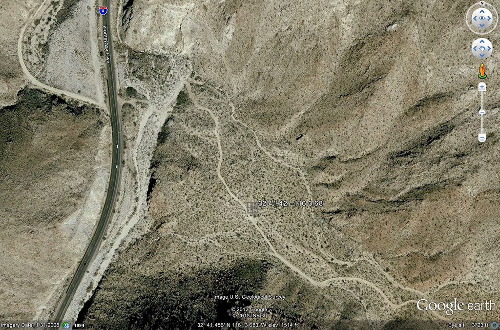
Miner's Shack by tomteske, on Flickr
|
|
|
link
|
|
dsefcik Administrator Posts: 2634
6/21/2012
|
I did not get that far, the BLM Wilderness signs are right after that first U bend in the road. While I cannot advocate for driving past those signs I doubt anybody is out there checking right now. I will just park and hike in when I have time. The BP said they have not seen any shacks there but they know about the other one.
tommy750 wrote:
dsefcik wrote:
tommy750 wrote:
No ruins at all of the shack?
I didn't get far enough to really look, there are No Vehicles Allowed BLM Wilderness signs almost immediately after you get going. Of course that doesn't stop the Border Patrol. I asked the BP agents about it and they said they have seen the one down by the culvert but not anything going up into Myer Valley. I am going to hike in when I get a chance.
If we're talking about the second miner's shack down the eastbound lanes from the one near bolder creek, it maps on Google to the little plateau just yards up the dirt road from I-8. Just found the coordinates in an earlier post re your Island trip: 32 41.42 -116 3.68 Tom
Miner's Shack by tomteske, on Flickr
--
http://www.sefcik.com
http://www.darensefcik.com
http://www.carrizogorge.com
|
|
|
link
|
|
surfponto Administrator Posts: 1369
6/22/2012
|
You could always go with the BFG Mud Terrains KM2 
dsefcik wrote:
tommy750 wrote:
That's exactly how my alleged "Rugged Trails" tires looked about 50 yards after I left the pavement for the first time. Blew one out after hitting a pebble driving up Painted Gorge for a night hike up Carrizo Mt and spent an hour cursing Toyota for putting them on their TRD equipped Tundras while I wrestled with the spare in the dirt. Happy happy with the BFG A/Ts all around. Tom
Yeah, I have sliced two tires so far, both in Death Valley on rocks. Expensive buggers.
edited by surfponto on 6/22/2012
edited by surfponto on 6/22/2012
<em>edited by surfponto on 6/22/2012</em>
--
https://www.anzaborrego.net/


|
|
|
link
|
|
hikerdmb Posts: 423
6/22/2012
|
Daren,
Sorry I can't help with the stars, too many in too small an area. Just a guess though and judging by that fact that it looks like the leading edge of the Milky Way coming up, that it is the Trifid Nebula and the Lagoon Nebula just above the V of the mountains. And a little left and above that is the Eagle Nebula and the Wild Duck Cluster. The first 2 are pretty easy to find with good binoculars.
As far as tires, that looks terrible. Hopefully you are replacing those with something better. I got the BFG AT 285/70/17 for my Dodge. And I love them. Not sure if those have 3 ply sidewalls but there was an ad a few years ago referring to the 3 ply sidewall on BFG AT tires that went something like this... "The only thing you want out here that is two ply is your toilet paper." I too had a couple of flats in DV but mine were with Goodyear tires that came stock on my old Dodge.
Good job getting to the end of Rockhouse in your truck. That is tough and requires some patience and skill. I am assuming you did it solo with no spotter either. By comparison when I did my Rockhouse trip this spring it took me about an hour in my jeep to get to the end of the road. I did not see anything like your truck back in there. The other full size rigs I saw were parked at the split with Butler Canyon. A long time ago I took my old Dodge up that road but it did not have 4 doors or an 8' bed.
David
|
|
|
link
|
|
tommy750 Posts: 1086
6/22/2012
|
surfponto wrote:
You could always go with the BFG Mud Terrains KM2
Those look like they definitely would do! Tom
|
|
|
link
|
|
dsefcik Administrator Posts: 2634
6/22/2012
|
hikerdmb wrote:
Good job getting to the end of Rockhouse in your truck. That is tough and requires some patience and skill. I am assuming you did it solo with no spotter either. By comparison when I did my Rockhouse trip this spring it took me about an hour in my jeep to get to the end of the road. I did not see anything like your truck back in there. The other full size rigs I saw were parked at the split with Butler Canyon. A long time ago I took my old Dodge up that road but it did not have 4 doors or an 8' bed.
David
Thanks David, I did drive out with another BHS counter from the meeting, he had a 4Runner and I had to spot him
To be fair though he had less ground clearance. I did not need any spotting, that damn truck in 4WD Low is pretty amazing to me, it just crawls over anything it has clearance to get over. I did get a few differential and tail pipe scrapes though and there were some narrow spots I needed to just put the wheels up and over on.
I thought Scorpius was in the stars photo in the lower right but what do I know. The Milky Way was straight overhead around 1 or 2am when I woke to take a look.
--
http://www.sefcik.com
http://www.darensefcik.com
http://www.carrizogorge.com
|
|
|
link
|
|
hikerdmb Posts: 423
6/22/2012
|
You are correct Daren. That is scorpius. The 2 stars close together just to the right of the V make the stinger at the end of scorpius. And the cloud just above and to the left are the Trifid and Lagoon Nebula. Good call.
|
|
|
link
|
|
dsefcik Administrator Posts: 2634
6/23/2012
|
I was just looking more closely at the map and I take back my comment. I parked at the small clearing just below the marker on the map. I did not go look anywhere on that side of the road though....humm, next trip out.
dsefcik wrote:
I did not get that far, the BLM Wilderness signs are right after that first U bend in the road. While I cannot advocate for driving past those signs I doubt anybody is out there checking right now. I will just park and hike in when I have time. The BP said they have not seen any shacks there but they know about the other one.
tommy750 wrote:
dsefcik wrote:
tommy750 wrote:
No ruins at all of the shack?
I didn't get far enough to really look, there are No Vehicles Allowed BLM Wilderness signs almost immediately after you get going. Of course that doesn't stop the Border Patrol. I asked the BP agents about it and they said they have seen the one down by the culvert but not anything going up into Myer Valley. I am going to hike in when I get a chance.
If we're talking about the second miner's shack down the eastbound lanes from the one near bolder creek, it maps on Google to the little plateau just yards up the dirt road from I-8. Just found the coordinates in an earlier post re your Island trip: 32 41.42 -116 3.68 Tom
Miner's Shack by tomteske, on Flickr
--
http://www.sefcik.com
http://www.darensefcik.com
http://www.carrizogorge.com
|
|
|
link
|
|
dsefcik Administrator Posts: 2634
7/2/2012
|
I received some pictures of me driving my truck from the the person who drove out with me thru Rockhouse Canyon. Nothing too dramatic but it sure seemed like it in my big ass truck.
This is the first section after Butler Canyon junction

Some random shots afterwards

---

---

--
http://www.sefcik.com
http://www.darensefcik.com
http://www.carrizogorge.com
|
|
|
link
|
|
ziphius Posts: 911
7/3/2012
|
That IS a big truck. Did you airbrush out all the scratches?!
<em>edited by ziphius on 7/3/2012</em>
--
http://www.coyotelearning.org
|
|
|
link
|
|
dsefcik Administrator Posts: 2634
7/3/2012
|
ziphius wrote:
That IS a big truck. Did you airbrush out all the scratches?!
No, more like I added a few more on this trip...

--
http://www.sefcik.com
http://www.darensefcik.com
http://www.carrizogorge.com
|
|
|
link
|