|
DRT Lakeside Posts: 62
12/10/2012
|
Took a day trip with the dog out to Yuha Desert.
I had wanted to get out to the Shell Beds since I was a kid and a friend gave me some fossil oysters. Figured I would swing by the Crucifixion Thorn Wilderness Area and then head out to the shell beds from the 98, maybe catch the geoglyphs etc., end up at the Dunaway exit and head out to Superstition Mt. area to visit some friends camping out there.
I have driven past the sign for the Crucifixion Thorn area a bunch of times and the map shows a campground, so I wanted to check it out. Not what I pictured, and may have been nicer in the past + it turns out the Crucifixion Thorns are right by the road anyway....
Heavy USBP presence but they were very friendly.
Forgot my map of the Yuha trails (turns out the maps are not that accurate, at least for me) It was fun, but the deep power sucking sand is not easy in our little samurai.
Made it to the shell beds, but I think many of the trails are sort of washed out or have meandered around. It was fun, but I want to go back and explore a little more when I have time to spare.
Pics and captions are here:
https://plus.google.com/photos/111004590236580500907/albums/5820349641107685665?authkey=CJbLg4X675j_Lg
Dave
PS one of the wind turbines was spinning on the way down, slowly and maybe just for show since the newspaper article said they were powering up. Also noticed on the way home in the dark that each tower has a blinking red light on top and a bunch of them blink in unison. All night long.....
|
|
|
link
|
|
surfponto Administrator Posts: 1369
12/10/2012
|
Like your Samurai. I always looked at those like mini FJ40 Land Cruisers 
Looks like a cool area to explore.
With regards to the wind towers and blinking lights check out these YouTube videos from a resident
DRT Lakeside wrote:
Took a day trip with the dog out to Yuha Desert.
I had wanted to get out to the Shell Beds since I was a kid and a friend gave me some fossil oysters. Figured I would swing by the Crucifixion Thorn Wilderness Area and then head out to the shell beds from the 98, maybe catch the geoglyphs etc., end up at the Dunaway exit and head out to Superstition Mt. area to visit some friends camping out there.
I have driven past the sign for the Crucifixion Thorn area a bunch of times and the map shows a campground, so I wanted to check it out. Not what I pictured, and may have been nicer in the past + it turns out the Crucifixion Thorns are right by the road anyway....
Heavy USBP presence but they were very friendly.
Forgot my map of the Yuha trails (turns out the maps are not that accurate, at least for me) It was fun, but the deep power sucking sand is not easy in our little samurai.
Made it to the shell beds, but I think many of the trails are sort of washed out or have meandered around. It was fun, but I want to go back and explore a little more when I have time to spare.
Pics and captions are here:
https://plus.google.com/photos/111004590236580500907/albums/5820349641107685665?authkey=CJbLg4X675j_Lg
Dave
PS one of the wind turbines was spinning on the way down, slowly and maybe just for show since the newspaper article said they were powering up. Also noticed on the way home in the dark that each tower has a blinking red light on top and a bunch of them blink in unison. All night long.....
edited by surfponto on 12/10/2012
--
https://www.anzaborrego.net/


|
|
|
link
|
|
DRT Lakeside Posts: 62
12/10/2012
|
It was a fun brief trip and lots more to explore. There are numerous campgrounds, but I didn't see much evidence of people having camped there aside from some old fire rings. Samurai has been reliable so far, big test today as I have a 4pm smog appt. Fingers crossed
Here are some of the fossil oysters from the reef. BLM says you can collect up to 25# for personal use. I just picked up a couple and gave them to a few teacher/geologist friends + 1 for my kids rock collection. (he's almost 20)

Wind tower videos are crazy. The shadow one made me think of what kind of flickering there is when all the turbines are going. Plus when the sun is low, the long shadows from those 400ft towers probably stretch a long way.
I was wondering how they get the power from each turbine to the station? Did they dig trenches for cable?
Also watched the documentary "Windfall" a while ago on netflix about a windfarm being pushed through in New York. Sort of one-sided but interesting in a land-grab sort of way and seems to have some stuff in common with Ocotillo project. It will be interesting to see how the wind stuff plays out long term.
|
|
|
link
|
|
ziphius Posts: 911
12/10/2012
|
That looks like an interesting area Dave. Dog enjoyed the trip too, heh? I bet there are a few shark teeth fossils in among the oyster fossils, but it takes some work to go through those fossil beds meticulously. Nice trip. - Jim
--
http://www.coyotelearning.org
|
|
|
link
|
|
AdventureGraham Posts: 170
12/10/2012
|
That's a fun area to explore. I might be out there this weekend.
|
|
|
link
|
|
anutami Posts: 491
12/10/2012
|
Looks like a lot of soft sand...Is that area street legal only vehicles or is it okay to ride quads and dune buggies out there?
|
|
|
link
|
|
DRT Lakeside Posts: 62
12/11/2012
|
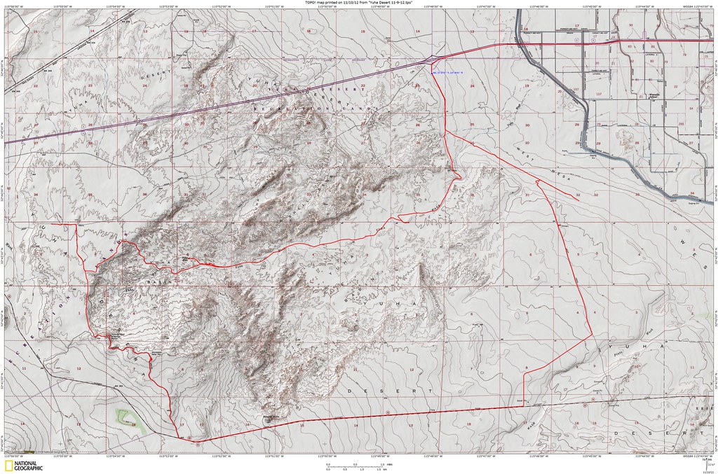
Most of the area is "limited use" which means you need to stay on the designated trails and have a street legal vehicle. However a couple of the larger trails are "open" which I think means anything goes, but not sure, you may want to double check with BLM.
Here are the only 2 readable maps I was able to find.
|
|
|
link
|
|
tommy750 Posts: 1086
12/11/2012
|
DRT Lakeside wrote:
Most of the area is "limited use" which means you need to stay on the designated trails and have a street legal vehicle. However a couple of the larger trails are "open" which I think means anything goes, but not sure, you may want to double check with BLM.
Here are the only 2 readable maps I was able to find.
The BLM has a paper map they hand out for free on Yuha routes of travel. The entire area is covered with roads and they're actually well marked every few hundred yards so offroad travel isn't really an issue. Does get pretty sandy as you head east in Yuha Wash. The rest seems not as bad. Tom
|
|
|
link
|
|
waning moon Posts: 34
12/12/2012
|
Yuha Basin / Bluffs brings back so many memories, it has always been mystical / magical, at least to me. First went there in early sixties when I was young, hiked most of the basin, the well (had water in the casings then), concretion and mud hills, pebble terraces with agate, quartz, jasper, petrified wood and palm, and of course the shell beds. Walking the bluffs there were 5 to 6 foot cleared circles, desert varnish heavy on the repositioned rocks, been that way for at least centuries, cannot remember if the geoglyphs were even known or fenced, but do not remember a fence. Melting old adobes were at the turn off road from highway into Yuha, by Coyote wash a few wattle and daub adobes also slowly melting.
Picked up a wrecked Datsun 1200 fastback in 1970, bought a wrecked counterpart (rear end damage) and welded them together, a couple of lift shackles and it was off road, all of Yuha was open, air out of the tires, R's kept up to 3k or over and went everywhere, never got stuck (what a lucky stupid kid I was) In the early 70's it was one of the off road places to be, very crowded on weekends, Yuha even served as a short course off road race track, I was there on the first Honda three wheeler and the place was being ruined, I stayed on the roads and would almost fall off and wreck a couple of times because I was looking at rocks and or plants, look there is desert holley, 'crash" look arrow weed, petrified wood, crash crash crash, I was not that good on a three wheeler.
It was easy to get lost in Yuha even after having been there a hundred times, but you could climb a bluff and always see the bunker, get your bearings, Bunker has been gone for a long time. My kids learned how to ride (on three wheelers) in Yuha, always went on destination rides, never understood making "tracks" like a hamster on a wheel, what is the purpose. By then a pipe corral had been put up around the bluff geoglyph but there was a hill climb diectly to the East and behind the enclosure, and the morons got in, I do not known how many times my family and I put boulders at the base of the hill climb, to try and block off the #%*!%& who had to destroy everything. I knew it would be closed to ORV's eventually and I agreed.
Stopped going in early 80's, kids almost grown and interested in other things, been back once or twice since. Why no one is there now has alot to do with the un-checked illegal immigrants entry, when the US economy was good, I understand campers, motorhomes left un-attended, while you took a ride, were often broken into.
Glad to see people going back, probably never camp there again, but a day trip is great,
Dave, thank you for the memories
DRT Lakeside wrote:
Took a day trip with the dog out to Yuha Desert.
I had wanted to get out to the Shell Beds since I was a kid and a friend gave me some fossil oysters. Figured I would swing by the Crucifixion Thorn Wilderness Area and then head out to the shell beds from the 98, maybe catch the geoglyphs etc., end up at the Dunaway exit and head out to Superstition Mt. area to visit some friends camping out there.
I have driven past the sign for the Crucifixion Thorn area a bunch of times and the map shows a campground, so I wanted to check it out. Not what I pictured, and may have been nicer in the past + it turns out the Crucifixion Thorns are right by the road anyway....
Heavy USBP presence but they were very friendly.
Forgot my map of the Yuha trails (turns out the maps are not that accurate, at least for me) It was fun, but the deep power sucking sand is not easy in our little samurai.
Made it to the shell beds, but I think many of the trails are sort of washed out or have meandered around. It was fun, but I want to go back and explore a little more when I have time to spare.
Pics and captions are here:
https://plus.google.com/photos/111004590236580500907/albums/5820349641107685665?authkey=CJbLg4X675j_Lg
Dave
PS one of the wind turbines was spinning on the way down, slowly and maybe just for show since the newspaper article said they were powering up. Also noticed on the way home in the dark that each tower has a blinking red light on top and a bunch of them blink in unison. All night long.....
|
|
|
link
|
|
tommy750 Posts: 1086
12/12/2012
|
waning moon wrote:
Yuha Basin / Bluffs brings back so many memories, it has always been mystical / magical, at least to me. First went there in early sixties when I was young, hiked most of the basin, the well (had water in the casings then), concretion and mud hills, pebble terraces with agate, quartz, jasper, petrified wood and palm, and of course the shell beds. Walking the bluffs there were 5 to 6 foot cleared circles, desert varnish heavy on the repositioned rocks, been that way for at least centuries, cannot remember if the geoglyphs were even known or fenced, but do not remember a fence. Melting old adobes were at the turn off road from highway into Yuha, by Coyote wash a few wattle and daub adobes also slowly melting.
Picked up a wrecked Datsun 1200 fastback in 1970, bought a wrecked counterpart (rear end damage) and welded them together, a couple of lift shackles and it was off road, all of Yuha was open, air out of the tires, R's kept up to 3k or over and went everywhere, never got stuck (what a lucky stupid kid I was) In the early 70's it was one of the off road places to be, very crowded on weekends, Yuha even served as a short course off road race track, I was there on the first Honda three wheeler and the place was being ruined, I stayed on the roads and would almost fall off and wreck a couple of times because I was looking at rocks and or plants, look there is desert holley, 'crash" look arrow weed, petrified wood, crash crash crash, I was not that good on a three wheeler.
It was easy to get lost in Yuha even after having been there a hundred times, but you could climb a bluff and always see the bunker, get your bearings, Bunker has been gone for a long time. My kids learned how to ride (on three wheelers) in Yuha, always went on destination rides, never understood making "tracks" like a hamster on a wheel, what is the purpose. By then a pipe corral had been put up around the bluff geoglyph but there was a hill climb diectly to the East and behind the enclosure, and the morons got in, I do not known how many times my family and I put boulders at the base of the hill climb, to try and block off the #%*!%& who had to destroy everything. I knew it would be closed to ORV's eventually and I agreed.
Stopped going in early 80's, kids almost grown and interested in other things, been back once or twice since. Why no one is there now has alot to do with the un-checked illegal immigrants entry, when the US economy was good, I understand campers, motorhomes left un-attended, while you took a ride, were often broken into.
Glad to see people going back, probably never camp there again, but a day trip is great,
Wow, what a great recollection of the Yuha area. My first trip there was this past August after the big storm. Was the only vehicle out there and the place looked fairly pristine considering how our deserts go. In view of your description of the past use, looks like it may bounce back. Except the geoglyphs which are so trashed it makes you want to cry. Thanks for sharing. Tom
|
|
|
link
|
|
dsefcik Administrator Posts: 2634
12/13/2012
|
Nice TR and pics, I need to make it out there someday. Nice find on the mylar balloon 
--
http://www.sefcik.com
http://www.darensefcik.com
http://www.carrizogorge.com
|
|
|
link
|
|
AdventureGraham Posts: 170
12/13/2012
|
I'll be camping near Ocotillo over the weekend with my family and plan on checking out the shell beds while we're out there.
Here are some photos of my past trips to the Yuha Basin.


Here's a map you can get off the BLM's website of the area.

edited by BorregoWrangler on 12/13/2012
|
|
|
link
|
|
anutami Posts: 491
12/13/2012
|
BorregoWrangle
Here's a map you can get off the BLM's website of the area.
edited by BorregoWrangler on 12/13/2012[/quote wrote:
That looks like a cool loop. (I assume you did the blue highlighted route) Do you think my F350 and camper could make it through?
|
|
|
link
|
|
AdventureGraham Posts: 170
12/13/2012
|
Nolan (anutami) wrote:
That looks like a cool loop. (I assume you did the blue highlighted route) Do you think my F350 and camper could make it through?
Yep. Your F350 won't have any problems. There my be some soft sand in certain areas but everything out there is pretty mild.
|
|
|
link
|
|
tommy750 Posts: 1086
12/13/2012
|
Not to try and swamp this topic with another TR, but must say, it is a nice little area. Was out there 11-9-12 in the dark (really late start) for a dinner and drink in the desert. Tried to find an old burial mound excavated in the '70s but no luck. Maybe Borrego Wrangler had better luck since he passed 20 ft to the west of it according to his map.
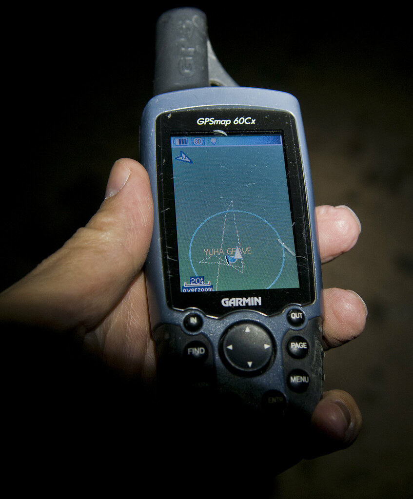
Yuha Grave GPS by tomteske, on Flickr
Did find BM "Ancient" off 247, a nice barely used road.
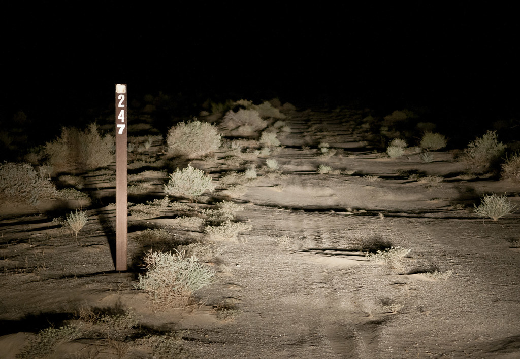
Road 247 by tomteske, on Flickr
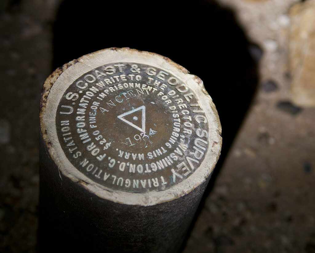
BM Ancient by tomteske, on Flickr
A Juan Bautista de Anza Trail sign.
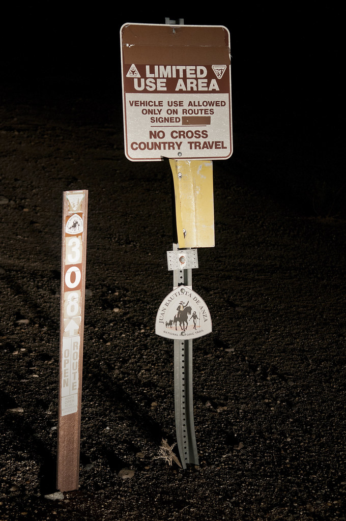
Juan Bautista de Anza Trail by tomteske, on Flickr
The monument.
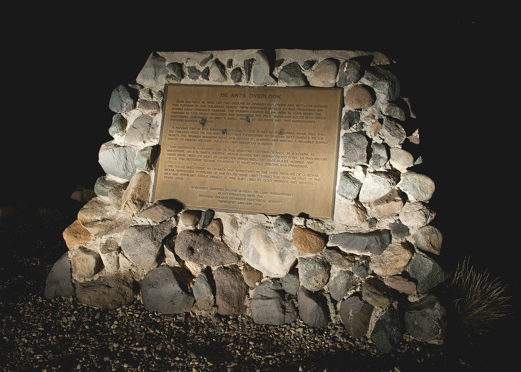
De Anza Overlook by tomteske, on Flickr
Can't recall if this is the east or west tower. How can you not be tempted to "empujar el boton rojo", but according to a USBP agent I spoke with recently, these two towers get frequent use during the summer months and both are functioning.
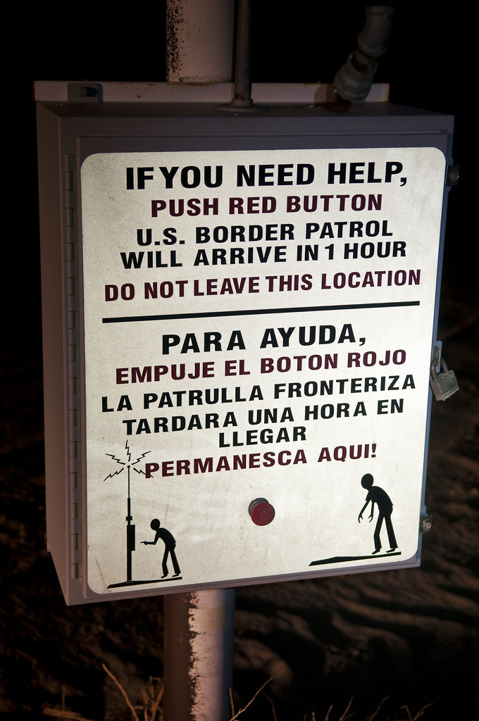
El Boton Rojo by tomteske, on Flickr
The trip with a quick asphalt cheat on Hwy 98. Enjoy your weekend out there, Borrego Wrangler. Should be really nice after the rains. Tom
Yuha Desert Trip by tomteske, on Flickr
|
|
|
link
|
|
anutami Posts: 491
12/14/2012
|
waning moon wrote:
I stayed on the roads and would almost fall off and wreck a couple of times because I was looking at rocks and or plants, look there is desert holley, 'crash" look arrow weed, petrified wood, crash crash crash, I was not that good on a three wheeler.
.
I really enjoyed reading your recollections! I am also a total "lookie loo". Here is a recent video on my MTB trip to the goat canyon trestle looking at all the old railroad material and not looking where I was going. I clipped my front tire on the railroad tracks! Good thing I did not do this over the edge of the cliff!
|
|
|
link
|
|
dsefcik Administrator Posts: 2634
12/14/2012
|
Nolan (anutami) wrote:
Here is a recent video on my MTB trip to the goat canyon trestle looking at all the old railroad material and not looking where I was going. I clipped my front tire on the railroad tracks! Good thing I did not do this over the edge of the cliff! [hijack thread] That is a cool spot to! Did you go check out the abandoned tunnel there? This tunnel ends quickly and has no supports in it [/hijack thread]

--
http://www.sefcik.com
http://www.darensefcik.com
http://www.carrizogorge.com
|
|
|
link
|
|
anutami Posts: 491
12/15/2012
|
Daren Sefcik wrote:
Nolan (anutami) wrote:
Here is a recent video on my MTB trip to the goat canyon trestle looking at all the old railroad material and not looking where I was going. I clipped my front tire on the railroad tracks! Good thing I did not do this over the edge of the cliff! [hijack thread] That is a cool spot to! Did you go check out the abandoned tunnel there? This tunnel ends quickly and has no supports in it [/hijack thread]
Hijack thread continues...Sorry..
Daren, had to check it out, but didn't venture too far... we almost have the same photo

|
|
|
link
|