|
dsefcik Administrator Posts: 2634
2/20/2013
|
That ridgeline will never look the same again......
That is all I could think as I slowly drove my truck out of Rockhouse Canyon staring at Villager, Rabbit and Peak 6582 and all of the up’s and down’s in between. 3 Days earlier I parked my truck at the Butler/Rockhouse Canyon junction and waited for my ride to the S22 trailhead parking area to start my backpack trip that would take me over three major peaks on the Santa Rosa Mountains. Bob from the anzaborrego.net website joined me for half of the climb up to Villager Peak, it was good to see him again as it has been almost a year since our last hike together. I was fortunate enough to have someone offer their water cache near Villager to me. Knowing I would need at least 3 liters per day plus a little extra for morning coffee I hauled 10 liters away from Villager and that put an extra 22 lbs on my back bringing the total pack weight up to around 65lbs, something normally not a big deal but the 10,000’+ elevation gain/loss of the trip took it’s toll on me with that extra weight.
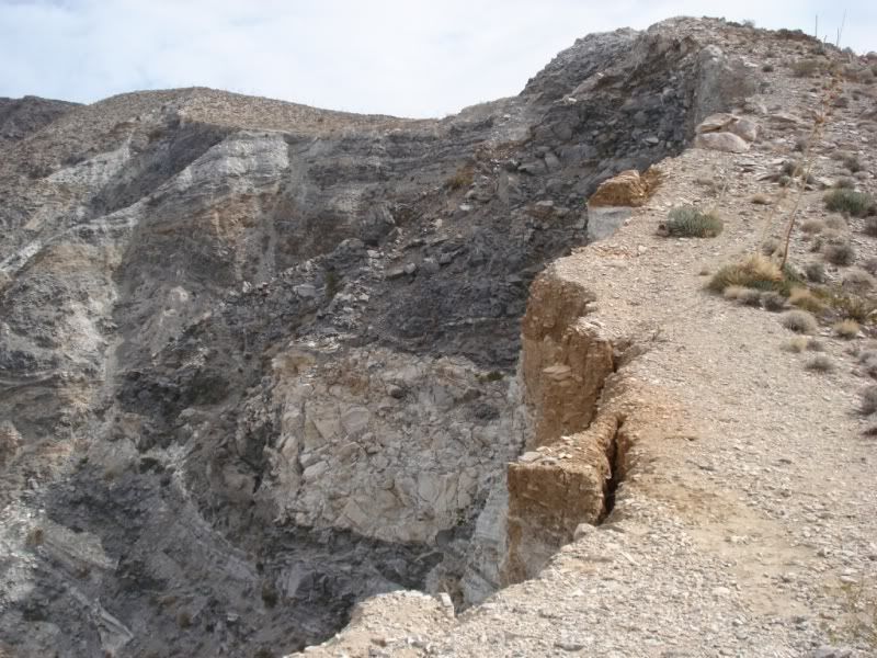
Steep cliffs on the west side of the trail going up to Villager

Probably old sleep circles

Heading up to Villager

The route up to Rabbit is somewhat uneventful but has some great views of the desert floor. There are numerous places to stop and camp overnight and enjoy the view, it would make a great trip for a one or two night backpack trip. The final ascent up Rabbit was tough with my heavy pack.
Rabbit Peak at sunset

Sunrise over the Salton Sea from Rabbit Peak

The winds were fierce and cold, I tucked my bivy and bag down into a tight brushy area next to a large buolder and managed to stay out of most of the wind

I read Doug Bear’s March 2000 report of crossing the Santa Rosa ridgeline when I got home and he mentions seeing something blue on one of the ridgelines that he believed to be a survey outpost of some sort, I also saw something blue down on a ridge and dismissed it as mylar balloons but now after reading his report I think it may be the same thing he saw.
Some very cool moss growing on the Pinyon Pines

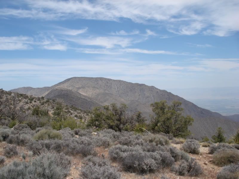
Looking back at Rabbit and Villager Peaks en route to Peak 6582

Someone has built a couple of larger cairns along the way to 6582 (off in the distance)

Bighorn Sheep scat and tracks were everywhere

The route between Rabbit and Peak 6582 shows some signs of Native American use. I found some pottery scatter and a few grinding slicks on the ridge line. I wonder if the Indians traveled the ridge line between Toro Peak and the desert floor to the Salton Sea or I guess Lake Cahuilla at the time..I am sure they did.
I have read other hiker’s reports that detail their trek from Toro Peak to the S22 or vice a versa and they all concur the same tough conditions between Rabbit and Peak 6582, the forest thick brush of Manzanita and Scrub Oak that make it almost impassable. I can also confirm the difficult passage to Peak 6582 with bloodshed and the loss of a favorite pair of pants and shirt due to tear wounds beyond repair. Leaving Rabbit Peak you are are on your own, there are no ducks, no use trail, nothing...pick your route. The bushwhack leaving Rabbit is mild and most of the trip to Peak 6582 is not too bad until the last ascent of the ridgeline that leads you to the peak, that is where it becomes extremely thick and impassable. Like other trip reports I found the best way to see the route options was to go out of my way and climb up some boulders and scout out the distant views.
The final ascent to 6582 was full of large boulders and Manzanita so thick that I could not hike thru it so I ended up dropping down into a drainage on the east side losing almost 700’ and then climbing back up again on the backside of the peak but it was worth it since it was void of the thick brush. I cannot overemphasize how thick the brush is the last mile or so on the final ascent.
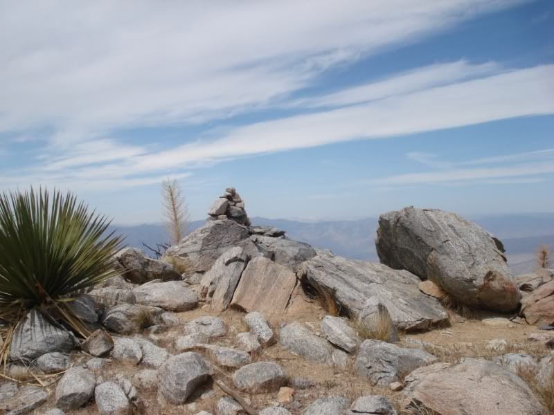
I could see the large cairn of 6582 in the distance as I summited from the east side

Looking back at Rabbit and Villager from large cairn on 6582

I read thru the entries in the register at 6582, it seems that the original “book #1” was damaged from moisture so only books #2, #3 & #4 exist and #4 is empty...these are small books BTW. I signed my name next to the last entry of 4-5-2012, almost a year ago. In all of my peak hikes that I know Jerry Schad has hiked I have always looked for his signature in the registries and never found one...until now. The early books here have his signature and I was pleased to find them....RIP Mr. Schad....

I knew I was running low on water but the thought of a second sunset and sunrise on the mountain peaks kept me there for one more night and then I was going to fast track my way down to Rockhouse Canyon and back to my truck the next morning. The wind died down a bit on 6582 that evening and after getting some food and booze in my gut I looked out over the eastern skies and was shocked at the overwhelming lights from the Coachella Valley.

The sunrise on 6582 was beautiful and the hoots of a nearby owl woke me early and got me going for the final day of the trip. I wanted to descend the ridge from 6582 as Jerry Schad describes in his book but I went too far south and ended getting cliffed out by steep boulder faces. I had to gently maneuver myself across the boulder faces with my heavy pack on to get to the other side where I could safely hike the remainder of the way down.
Sunrise over the Salton Sea from 6582, this panorama photo also shows Clark Dry Lake and Toro Peak

Yours Truly....burrr, it's cold....

Halfway down the ridge into Rockhouse Canyon

Down at the bottom of the Santa Rosa Mountains I followed an unnamed drainage to the main Rockhouse Canyon trail. Along the way I found some large morteros, pottery and a petroglyph panel with pictographs.
Basketball size morters

Cupules

Large Petroglyph Panel

Some rock art on the petroglyph panel

The temps were warming up and I was running out of water and still had close to 7 miles left to hike back to my truck which I left parked at the Butler/Rockhouse Canyon junction. I did not see any other people during my 3 days of hiking but I did see at least 10 cars parked or driving the Rockhouse Canyon trail that day so it was a very busy holiday weekend for sure. I had seen probably quite a few Ocotillos that were getting very green but none blooming so I was surprised to see this guy right next to my truck as I finished up my trip, great ending.
Ocotillo blooming

This trip was tough for sure and I underestimated my water needs and suffered accordingly, the desert floor temps were in the high 70’s during the day and the mountain peaks were in the low 30’s at night. My GPS track showed total mileage near 29 miles and total elevation gain/loss just under 10,000'. I have to say this was a great trip and I want to thank everyone who helped me make it happen.
CraigS - Water cache at Villager
Sam - Ride from RHC to the S22 bright and early
Bob - Trip partner for a few hours
Total Mylar Balloon count - 5

http://www.sefcik.com/2013/02/villagerrabbit6582-peak-loop-via.html
edited by dsefcik on 2/26/2013
--
http://www.sefcik.com
http://www.darensefcik.com
http://www.carrizogorge.com
|
|
|
+1
link
|
|
herofix Posts: 30
2/20/2013
|
Great report and pics! Those were amazing views you had...thanks for sharing.
|
|
|
link
|
|
Andy Posts: 13
2/20/2013
|
I'm glad you had a successful, albeit tough trip Daren. I know what you mean about water and having to lug every drop along that ridge. I had a failed attempt a few years ago when I hiked over from Cactus Spring with a planned exit at S22 and ended bailing out into Martinez (the only sure bet for water at the time). Thanks again for the report.
|
|
|
link
|
|
ziphius Posts: 911
2/20/2013
|
Holy crap. Congrats on making it back safely. The descent from 6582 to RHC sounds like it was sketchy for a portion. Really cool that you found Jerry's register entry. So.... you picked up 10 cached liters near Villager.... how many liters did you carry prior to that point? The petroglyph / picto panel must be the one that Schad mentions in his book, heh? Who was your booze sponsor? Congrats. - Jim
PS - Schad mentions that the rock tower on 6582 was built sometime in the 1970s by unknown forces (perhaps extra-terrestrial?  ). The tower looks pretty stable after all this time, given how windy it gets up there, earthquakes, etc. Any evidence that it has been maintained / repaired over time? ). The tower looks pretty stable after all this time, given how windy it gets up there, earthquakes, etc. Any evidence that it has been maintained / repaired over time?
edited by ziphius on 2/20/2013
--
http://www.coyotelearning.org
|
|
|
link
|
|
surfponto Administrator Posts: 1369
2/20/2013
|
Hey Daren,
Yeah I felt a bit guilty leaving you up there  Glad the trip went well. Glad the trip went well.
Took me 2.5 hours to hike back down so you are right it was faster going downhill.
Awesome you found Jerry Schad's name in the registry as well as the petroglyphs.
Really adds the icing on the cake for your great trip.
Bob
--
https://www.anzaborrego.net/


|
|
|
link
|
|
hikerdmb Posts: 423
2/20/2013
|
Daren,
You have done some tough trips in the couple years I have known you but this one may be the roughest. Great job setting your goal and making it. I love the pics from the top of the sunrise and the lights in Coachella Valley. Congrats! Sorry about your favorite pants and shirt.
David
|
|
|
link
|
|
mrkmc Posts: 87
2/20/2013
|
dsefcik wrote:
pack weight up to around 65lbs, something normally not a big deal bu
65 lbs, Dang! Did you carry your rock collection with you?
Great trek Daren! That is a great accomplishment covering that terrain with all that water. The Santa Rosas are my favorite of all the ranges I have visited. Was that Craigs cache you got to use?
edited by mrkmc on 2/20/2013
|
|
|
link
|
|
dsefcik Administrator Posts: 2634
2/20/2013
|
Jim (ziphius) wrote:
So.... you picked up 10 cached liters near Villager.... how many liters did you carry prior to that point? The petroglyph / picto panel must be the one that Schad mentions in his book, heh? Who was your booze sponsor? The tower looks pretty stable after all this time, given how windy it gets up there, earthquakes, etc. Any evidence that it has been maintained / repaired over time? Check out the article Schad wrote for Desert Magazine back in 1978 http://mydesertmagazine.com/files/197802-DesertMagazine-1978-February.pdf there is a photo of the large cairn from that time and it has changed a little but not much. I carried 3 liters up to Villager and then hauled the extra 10 with me from there, I literally had drops left when I got back to my truck. The petros Schad mentions are different, those are the Corps ones. Booze Du Jour on this trip was Jim Beam mixed 50/50 with Barcardi Dark Reserve....
--
http://www.sefcik.com
http://www.darensefcik.com
http://www.carrizogorge.com
|
|
|
link
|
|
dsefcik Administrator Posts: 2634
2/20/2013
|
mrkmc wrote:
65 lbs, Dang! Did you carry your rock collection with you? Was that Craigs cache you got to use? Yeah I still have some old heavy backpack stuff, I am slowly upgrading and knocked about 12lbs off for this trip by getting a new down jacket and sleeping bag and leaving behind some crap I always take but never use. CraigS was kind enough to let me use his water, he was gonna go with me but his ankle is still messed up.
--
http://www.sefcik.com
http://www.darensefcik.com
http://www.carrizogorge.com
|
|
|
link
|
|
tommy750 Posts: 1086
2/20/2013
|
That is one impressive trip, Daren! The Schad entry is really neat. Great pics. Tom
|
|
|
link
|
|
dsefcik Administrator Posts: 2634
2/20/2013
|
dsefcik wrote:
mrkmc wrote:
65 lbs, Dang! Did you carry your rock collection with you? Yeah I still have some old heavy backpack stuff, I am slowly upgrading and knocked about 12lbs off for this trip by getting a new down jacket and sleeping bag and leaving behind some crap I always take but never use. My camera gear is 7lbs alone...I need to change that...
--
http://www.sefcik.com
http://www.darensefcik.com
http://www.carrizogorge.com
|
|
|
link
|
|
DesertWRX Posts: 135
2/20/2013
|
Great trip report and really enjoyed the photos. You should have seen the snow up there this morning!
|
|
|
link
|
|
dsefcik Administrator Posts: 2634
2/22/2013
|
To follow up with the brush bypass and cliffed out route just in case anyone else is planning a similar route, here are some Google Earth images showing my route.
GE doesn't do justice to the thick brush but if you stay left on the ridgeline you will be staring at huge boulders and dense manzanita, here are two view angles of where I ended up going around a lot of it on the east side but doing that caused me considerable more elevation gain/loss


This is the finger ridge coming down from 6582, Schad's route is on the left of my track, I missed it and ended coming down right on top of this boulder cliff. I either had to climb back up and go around or try to maneuver horizontally across the boulders.....I chose the maneuver and it was a bit sketchy with the pack on....lesson learned, go down on the other ridge....

Close up of the boulder cliff and my horizontal tracks across it

--
http://www.sefcik.com
http://www.darensefcik.com
http://www.carrizogorge.com
|
|
|
link
|
|
surfponto Administrator Posts: 1369
2/22/2013
|
Really puts your trek in perspective.
Serious climbing!!!
dsefcik wrote:
To follow up with the brush bypass and cliffed out route just in case anyone else is planning a similar route, here are some Google Earth images showing my route.
GE doesn't do justice to the thick brush but if you stay left on the ridgeline you will be staring at huge boulders and dense manzanita, here are two view angles of where I ended up going around a lot of it on the east side but doing that caused me considerable more elevation gain/loss
This is the finger ridge coming down from 6582, Schad's route is on the left of my track, I missed it and ended coming down right on top of this boulder cliff. I either had to climb back up and go around or try to maneuver horizontally across the boulders.....I chose the maneuver and it was a bit sketchy with the pack on....lesson learned, go down on the other ridge....
Close up of the boulder cliff and my horizontal tracks across it
--
https://www.anzaborrego.net/
|
|
|
link
|
|
TR Posts: 67
2/25/2013
|
Daren,
Weight was a serious consideration when I swithed from my point and shoot Nikon, to a DSLR. From what I read one of the lightest weight cameras was the Olympus E-620. With a 14-42 mm lens it weighs just 28 oz. I also carry a 70-300 mm lens which weighs 25 oz. I've been really happy with it so far. I bought it reconditioned through Cameta Camera out on NY. I bought the 70-300 mm lens used on E-bay.
Tom
|
|
|
link
|
|
dsefcik Administrator Posts: 2634
2/25/2013
|
Thanks Tom, I am currently looking at the Canon S100 but will also look into your recommendations.
TR wrote:
Daren,
Weight was a serious consideration when I swithed from my point and shoot Nikon, to a DSLR. From what I read one of the lightest weight cameras was the Olympus E-620. With a 14-42 mm lens it weighs just 28 oz. I also carry a 70-300 mm lens which weighs 25 oz. I've been really happy with it so far. I bought it reconditioned through Cameta Camera out on NY. I bought the 70-300 mm lens used on E-bay.
Tom
--
http://www.sefcik.com
http://www.darensefcik.com
http://www.carrizogorge.com
|
|
|
link
|
|
surfponto Administrator Posts: 1369
2/25/2013
|
Hey Daren,
That is the one I have.
Love the Canon S100. Also cool that it can do 1080p video.
Bob
dsefcik wrote:
Thanks Tom, I am currently looking at the Canon S100 but will also look into your recommendations.
TR wrote:
Daren,
Weight was a serious consideration when I swithed from my point and shoot Nikon, to a DSLR. From what I read one of the lightest weight cameras was the Olympus E-620. With a 14-42 mm lens it weighs just 28 oz. I also carry a 70-300 mm lens which weighs 25 oz. I've been really happy with it so far. I bought it reconditioned through Cameta Camera out on NY. I bought the 70-300 mm lens used on E-bay.
Tom
--
https://www.anzaborrego.net/
|
|
|
link
|
|
rockhopper Posts: 678
2/25/2013
|
Daren,
Congratulations on your epic expedition! Going solo climbing thru deer trails, off the steep rocky drop offs with full pack
is truely unique sensation. As about ALIVE as you can be! Good news about the water cache'. I drink alot too!
Did you use 2 hiking poles or just one as in the photo? I can see why you desended on the nose to the right (photo) from the ridge down to RHV. The other one musta looked kinda spikey going down.
Oh yes, I agree on the Google Earth thing. NO WAY does it do justis compared actual boots on the ground. Like, oh yeah, looks like I can cover maybe 1.5 to 2 mi an hour over that ground. NOT!
Again, congrats. Glad you made in back without major spillage or tumbles!
|
|
|
link
|
|
anutami Posts: 491
2/25/2013
|
Love your reports!!!!!!!!!!!!!!!
|
|
|
link
|
|
dsefcik Administrator Posts: 2634
2/25/2013
|
rockhopper wrote:
Did you use 2 hiking poles or just one as in the photo? Just the one, I sometimes take a big wood handle from a broken rake but it weighs 1.5lbs and somebody I know gave me a carbon fiber ski pole a couple weeks ago so I took that instead. The wooden rake handle works way better for bashing brush out of the way!
--
http://www.sefcik.com
http://www.darensefcik.com
http://www.carrizogorge.com
|
|
|
link
|
|
TR Posts: 67
2/25/2013
|
Bob and Daren;
That's one short coming of the Olympus E-630. It doesn't take videos.
Tom
|
|
|
link
|
|
ziphius Posts: 911
2/26/2013
|
Thought I'd throw in my 2 cents since Daren's thread evolved into a camera discussion. If you are going to be bush-whacking, descending crazy ridges, occasionally getting rained / snowed on, dropping your pack with your camera in it, you may as well go for one of the waterproof / shockproof point and shoot models. Because these cameras are so LIGHT, they are more likely to be at-the-ready in a shirt pocket when fleeting photo opportunities arise. The 'waterproof' features are usually only good to 20-30 ft., but that is enough for backpacking. It also allows you to do crazy things like submerging your camera in a spring to shoot photos/video of dragonflies in reeds above the surface, smearing peanut butter on the camera and leaving it on in video mode for 30 minutes (secured to a bush) while you go for a walk to see what the ravens will do in your absence....or any other crazy ideas you come up with. Also makes getting the dust off your camera easy in the field, just pour water over it! I've got an old Olympus Stylus 850 with shock / water proof features, it's what I use for all my forum photos. The newer models, such as the Olympus Tough Series look even better at 14 megapixels.
--
http://www.coyotelearning.org
|
|
|
link
|
|
dsefcik Administrator Posts: 2634
2/26/2013
|
I just ordered a new Canon S100 from Amazon so I will give that a try....7ozs vs 7lbs.....
--
http://www.sefcik.com
http://www.darensefcik.com
http://www.carrizogorge.com
|
|
|
link
|
|
surfponto Administrator Posts: 1369
2/26/2013
|
Nice
Now you can show me how to use mine
dsefcik wrote:
I just ordered a new Canon S100 from Amazon so I will give that a try....7ozs vs 7lbs.....
--
https://www.anzaborrego.net/
|
|
|
link
|
|
dsefcik Administrator Posts: 2634
2/26/2013
|
Gonna miss my 10mm ultra wide angle lens...it has become my favorite.
--
http://www.sefcik.com
http://www.darensefcik.com
http://www.carrizogorge.com
|
|
|
link
|
|
rockhopper Posts: 678
2/26/2013
|
Back on the hike thread
Here is my 2012 pic of your first photo taken for a comparo.
All my nice full frame photos got all jacked up in the new and improved photobucket. Arrrrghhhh!
Here's a pic a few days after you came back ( taken off webcam)
now that would have been interesting!
edited by surfponto on 2/27/2013
|
|
|
link
|
|
dsefcik Administrator Posts: 2634
2/26/2013
|
Yeah, snow on the ridge would have been extra fun. I did see some patches of snow/ice still left on the east side of Rabbit when I was there.
--
http://www.sefcik.com
http://www.darensefcik.com
http://www.carrizogorge.com
|
|
|
link
|
|
surfponto Administrator Posts: 1369
2/27/2013
|
Hey Rockhopper
I thinkI fixed your photo size issue.
Bob
rockhopper wrote:
........
All my nice full frame photos got all jacked up in the new and improved photobucket. Arrrrghhhh!
--
https://www.anzaborrego.net/
|
|
|
link
|
|
rockhopper Posts: 678
2/27/2013
|
Surf,
You fixed my photos! How did you do it??. What do I do to fix my "new" photobucket account. I should have left the old account alone! Sorry don't mean to hijack, but photos look soooooo much better. The snow on the Santa Rosas looks way better now!
A big THANKS
rockhopper
|
|
|
link
|
|
surfponto Administrator Posts: 1369
3/1/2013
|
Hi again
I used the full photo link for the pics
I think it is under "Direct Link" in photobucket
Bob
rockhopper wrote:
Surf,
You fixed my photos! How did you do it??. What do I do to fix my "new" photobucket account. I should have left the old account alone! Sorry don't mean to hijack, but photos look soooooo much better. The snow on the Santa Rosas looks way better now!
A big THANKS
rockhopper
--
https://www.anzaborrego.net/
|
|
|
link
|
|
rockhopper Posts: 678
3/1/2013
|
Thanks,
I think I figured out the new photobuket too. It requires an extra step to post full sized pics.
One more of Villager
edited by rockhopper on 3/1/2013
|
|
|
link
|
|
AdventureGraham Posts: 170
3/18/2013
|
Epic trip, Daren. Well done!
|
|
|
link
|
|
DesertWRX Posts: 135
4/6/2013
|
There's a race up to Villager Peak and back this morning. Permitted and the whole shebang. Don't know how many are running it except the parking area is full.
|
|
|
link
|
|
dsefcik Administrator Posts: 2634
4/6/2013
|
Gut check king of the hill
http://gutcheckfitness.com/king-of-the-hill/registration-2013/
--
http://www.sefcik.com
http://www.darensefcik.com
http://www.carrizogorge.com
|
|
|
link
|
|
DesertWRX Posts: 135
4/7/2013
|
Choose from two divisions:
- Fleet of Feet division - This is a standard trail run with fitness challenges along the way and water stations. You will start the race at 5AM. You will have 12 hours to complete the course.
- Bad Add division - This is an unsupported trail run/hump with more extreme challenges along the way. Must carry weighted pack (50 lbs. for men, 30 lbs for women), plus all of your own food and water, there are no water stations allowed. Life insurance policy required! Only the truely bad ass need apply! Only the truly 'insane' need apply! You will start the sufferfest at 9PM on Friday, April 5th. You will have 21 hours to complete the course.
This IS one of the most difficult trail races in Southern California and has NEVER been raced before our 2012 event! There will be an option to turn around at Villager Peak (mile 7ish) due to difficulty and time cut-off.
You MUST register now as we can only allow 250 Fleet of Feet runners & Bad Ass backpackers due to the size & difficulty of the trail.
You are not affraid of a little Rabbit are ya?!
Looks like a typo with the Bad "Add"!
edited by DesertWRX on 4/7/2013
|
|
|
link
|
|
dsefcik Administrator Posts: 2634
4/8/2013
|
Thanks DesertWRX....I used to do races like that for years but not much anymore. Once they stared getting popular the entry fees went way up, the participant numbers turned into crowds and there were too many rules/regulations. They were much more enjoyable when they were just a group of people who went out doing it for fun.
--
http://www.sefcik.com
http://www.darensefcik.com
http://www.carrizogorge.com
|
|
|
link
|