4/1/2014
Topic:
Chuckwalla Mountains, The Bradshaw Trail
ImpatientHiker
|
Hello, I'm new here. Great TR. In the late 70's I was camping with my friend & his parents in Fish Creek above Olla Wash and a kit fox was circling just outside the firelight. When we went to bed my friends dad left a cup with some beer in it out for the fox. We awoke to find the beer gone and in its place a small poop. -Robert |
4/6/2014
Topic:
Jacumba Mtn from Tule Mtn
ImpatientHiker
|
This morning I had a chance to see some rugged ridgeline a amazing views. Parked at north base of Tule Mtn near Sacatone Spring in McCain Valley and started off about 6:30. Climbed Tule and followed ridge over a bump & down thru a valley to a peak overlooking Carrizo Gorge. I dropped down a steep main ridgeline from there to the Carrizo streambed where I turned north. I turned up a canyon just before Goat Canyon which led to an old workcamp and a ridge over a tunnel straight into the Jacumba mtn spine. It took a lot of climbing to stay on that ridge all the way to Jacumba Mtn where I stopped for lunch at 12:15.
The return was pretty tough as I just beelined it back to the gorge. There were a lot of canyons and little ridges to cross before I got close enough to the gorge to pick a ridge to descend. My first choice cliffed out after I had descended quite a ways and had to climb all the way back up to traverse across to another ridge. That one was steep but it worked and after some bushwacking thru the tamerisk I was climbing back out of the gorge. I picked a ridge just south of my earlier descent and followed it straight up to Tule by 4:15
I stopped often and saw some really cool stuff but man, that gorge ain't easy to get across.
edited by ImpatientHiker on 4/7/2014
edited by ImpatientHiker on 4/7/2014 |
4/7/2014
Topic:
Jacumba Mtn from Tule Mtn
ImpatientHiker
|
Thanks guys. I really appreciate the time, effort, & sophistication in your TR's. I really just wanted to write something while route was still fresh in my mind. Don't know how to post pics yet, recorded tracks & pics on Strava (Robert Hunt San Diego). My dad (by choice) was friends w/the desert section chief of 30+years so I've heard plenty about gorge area.
Jim, so right you are! Took me all day to go just 13 miles (& 7100 ft).
-Robert |
4/14/2014
Topic:
Quick Trip Thru Storm Cyn from Pine Valley
ImpatientHiker
|
Although the majority of this trip was not within Borrego, the goal was to spend some time in the desert. On sat 4/12/14 I attempted to run up Noble Cyn to just north of Monument Peak, drop down the main ridge east to Storm Cyn, ascend the main ridge below Garnet Pk, and return to Pine Valley. Everything was going great until the descent into the desert. By the time I dropped to about 5,000 ft, the sustained wind coming up over the ridge was making it very difficult to remain on my feet. I had a great view of the planned ascent ridge and could see some very exposed rock sections higher up. As I was already getting hit with airborn debris and having trouble seeing (too windy for my glasses), I decided to cut it short and descended a minor ridge directly into Storm Cyn. There was a large Granite outcrop that entailed some thought to downclimb but the Chariot fire had cleared the brush I found a good line to the valley floor. The stream is flowing nicely and the results of the fire are starkly apparent. There is a large amount of earthen debris in all chutes and gullies that has been cut thru by rains since. There is no brush and many beautiful little waterfalls with ferns, young poison oak, and a large amount of flowering plants as well (+frogs). Looking up, I saw many talus slopes that don't appear on Google Earth as those images are still pre-fire. This proved to be a bit of a challenge when I first started up the minor ridge south of Garnet and had to do the old two steps foreward, one slide back dance. The rest of the climb went quick as it was short and I didn't even need to refill at Penny Pines before returning to my car in Pine Valley.
The Chariot fire has really opened up that water-feature filled canyon and I can't wait to return, get a little further out towards Agua Caliente, and come back up that steep ridge to Garnet Peak. Beware the skeletons of the brush that has been there my whole life. Although they look like insignificant twigs and sticks, they are really stiff daggers that were fire-hardened while still vibrant & pitch-filled. Once again, sorry for the lack of photos, I took some with my phone and really gotta figure out how to make a pretty TR. 26.5 miles & 6,200 ft.
[IMG]http://i.imgur.com/jVgDL3zl.jpg "border=0"[/IMG]
[IMG]http://bit.ly/1jtQSid[/IMG]Click For Full-Size Photo.
edited by ImpatientHiker on 5/14/2014
edited by ImpatientHiker on 5/14/2014 |
4/21/2014
Topic:
Blair Valley Meditation Retreat 4/11 - 4/20
ImpatientHiker
|
Wow. I love the desert for its dichotomy of scale. From the mountains to the really small rocks (otherwise known as sand). Geological processes like gradual uplifting to sudden flash floods. My own experiences usually involve scarfing calories and seeing as much as I can while still trying to notice the details.
Thank you for another perspective (& for cleaning up). I would bet that the charred wood you encountered once held all those nails.
-Robert |
5/18/2014
Topic:
Another shot at Storm Canyon
ImpatientHiker
|
Yesterday Dave "Cappy" Capon, Steve Y., & I attempted complete a loop from Penny Pines to the desert floor & back.
We started off just before sunrise and made our way south on the PCT to a highpoint just north of Monument Peak. We cut off-trail east and begain to descend the main ridge. The wind started up & made downclimbing quite difficult as our feet would be forcibly pushed away from their intended targets. Dave seemed to really enjoy the routing as he was expecting us to have dropped down one of the adjoining canyons. He wisely decided to turn back a third of the way down, I could see him getting pushed around by the wind as he made his way back up.
The wind didn't let up all day but, as Steve put it, we soon got used to it as if we were getting our sea-legs. There were a few steep but managable arettes on the ridge and we made the desert floor in about 2 1/2 hours. It was noticibly hotter down there but the wind made it bearable. We were treated to a foot-wide, clear running stream of water in Storm Creek and took a break in the shade of a small bank to eat a snack.
We then turned our attention to the main ridge leading up to Garnet Peak. We attacked the lower slope seperately & rejoined where the ridge narrowed. The terraine got quite a bit steeper & bushier as we ascended. I was constantly surprised by the lack of animal (or human) use trails as we were on the only possible route around. We saw cairns at two ridge-peaks early on but that was it. There were two spots that required some climbing but I find it hard to believe deer, sheep, or people would be turned back by those short segments.
We were pleasantly surprised below Garnet Peak when we came over a rise and saw that the main ridge bypassed a face that we thought had the potential to send us back to the desert floor. We summited Garnet and jogged down the PCT to the car by noon. |
7/28/2014
Topic:
Carrizo Gorge
ImpatientHiker
|
Nice summertime desert trek guys! What heartbreak to see the lamb going thru such difficult times, hope it's able overcome, survive, & thrive. On another note, is it possible to use Dstretch on the Bromo picture? |
10/14/2014
Topic:
Ghost Mountain with Huel
ImpatientHiker
|
Soon after his passing, somebody spraypainted "RIP Huell Howser" on the railtanker next to the Goat Canyon trestle. |
10/24/2014
Topic:
Water at Dos Cabezas Spring?
ImpatientHiker
|
Hi everybody. I am planning on taking advantage of the great weather this weekend by running a loop that I've thought about for years. The plan is to run from Sacatone Overlook to the trestle, to Dos Cabezas Spring, to Jacumba Mtn, down (north) the Jacumba Mtn spine, and back to car. If anybody has any recent knowledge of the flow at Dos Cabezas Spring, it would be greatly appreciated. Although I have never seen this spring dry, the condition of other water sources I've been to over the last couple of months has me quite concerned. If it's dry...Borrego Days-here I come! |
10/24/2014
Topic:
Water at Dos Cabezas Spring?
ImpatientHiker
|
dsefcik wrote:
No idea on spring level but I have seen normally wet areas this year completely dry so plan accordingly. I have hiked sacatone to goat cyn a few times, I can't really think where you will be &quotrunning&quot, and about a 3'k elevation gain/loss. Be sure to report back!
edited by ImpatientHiker on 10/24/2014
Thanks for the quick reply. I'll be running the 7,892 little 20ft stretches between rock scrambles haha. If the spring is dry, I plan on skipping the Jacumba Mtn range portion & beelining it back to the vehicle. This drought has begun to reach deep underground, the adobe under my yard in Normal Heights has shrunk over 3" below the sidewalk! I'm busy as heck Sat night & Sunday, so I may not be able to post anything til next week but I will.
edited by ImpatientHiker on 10/24/2014 |
10/25/2014
Topic:
Tule Mtn/Dos Cabezas Spring Loop
ImpatientHiker
|
This morning my buddy Nick and I got to enjoy the sun rising over Jacumba Mtn and setting over Tule Mtn in one big run/scramble.
We left Sacatone overlook and climbed Tule Mtn just in time to see the pink sky spit out the heat-maker. From Tule, we followed its' main N-NE ridge all the way to the bottom of Carrizo Gorge just below Goat Cyn and climbed up to the Trestle for an unnerving walk across one of its' weathered catwalks.
Dos Cabezas Spring was to be the first stop we would make as we were anxious to know if it was dry or not. We started out with over a gallon each but found ourselves going thru it pretty quickly as the day heated up. When we climbed into the dry reeds around the spring, we could hear a gurgle and knew the day had gotten better already.
After a quick break to top off water and to eat, we beelined it over multiple Valley of the Moon-like rockpiles full of cool caves, shapes, & climbs. This led us up to the main Jacumba Mtn ridgeline mistakenly about 0.6 miles north of Jacumba Mtn.
At this point we were behind schedule and decided not to dance with climbing back out of the gorge to the car in darkness and skipped the peak, beelining it to Tule Mtn. The ridges leading into the east side of the gorge are pretty steep overall but totally doable. Still, it was a little worrisome not knowing if our chosen ridge would get us down until we were actually standing on the tracks. From there, we got back onto the ridge on the other side of the tracks & continued to the floor of the gorge.
At this point, we went directly across Carrizo Wash and attacked the west wall of the gorge and its' ridges up to Tule reaching the car from the wash in an hour and 15 minutes.
What a great day of views, wildlife, and exploring. I used Strava for this and some pictures are attatched to that post. http://app.strava.com/activities/211669728
edited by ImpatientHiker on 10/25/2014 |
12/9/2014
Topic:
Borrego Palm Canyon Backpack
ImpatientHiker
|
Great TR. Of all the exploring I've done in Borrego, I've always considered Palm Cyn 'touristy' and have never gone up it. Thanks for opening my eyes. Your pic's remind me of the canyons west of Laguna Salada in Baja. The horsetails, or Equisitum, has an ancient lineage. Whenever I pass through an area containing it, I always imagine giant dragonflies & dino's.
Jim, you got me, the first thing I did after reading Daren's TR was open up Google Earth. I thought, wow, it'd be fun to do the whole cyn-looks choked-can I bypass parts-would I need permission-where would I park? It was then that I realized that I too am a mapstur.....
On a sidenote, on Sun I hiked/jogged from McCain Vlly by Sombrero and down a ways to the desert & back. The ground sucked up that recent rain as I saw no signs of water flow anywhere. This storm expected Fri might actually cause some runoff due to the ground still being wet from the last one. |
12/10/2014
Topic:
Pepperwood Canyon to Canebrake Valley
ImpatientHiker
|
Nice pic's quotes. I was out just south of Sombrero that same day & also saw cat tracks. Kinda freaked me out with so many places to be ambushed with all the overhangs & such. Thanks for the report, definately stokes my lust to wander! |
1/2/2015
Topic:
Plane Wrecks
ImpatientHiker
|
Very interesting! I've come across a couple but never knew about this or the one near Blair either. Anybody see a link between this wreckage and the ejection seat Daren found recently?
Btw, I tried to summit Whale Pk from Pinyon Mtn w/my kids yesterday and failed because the snow was too deep. We also got turned back by deep snow and buried cholla trying to overland it from Dos Cabezas Spring to the Goat Cyn Trestle, crazy! |
1/2/2015
Topic:
Plane Wrecks
ImpatientHiker
|
Nolan (anutami) wrote:
ImpatientHiker wrote:
Very interesting! I've come across a couple but never knew about this or the one near Blair either. Anybody see a link between this wreckage and the ejection seat Daren found recently?
Btw, I tried to summit Whale Pk from Pinyon Mtn w/my kids yesterday and failed because the snow was too deep. We also got turned back by deep snow and buried cholla trying to overland it from Dos Cabezas Spring to the Goat Cyn Trestle, crazy!
Wow!! Would love to see some pics if you have any!!!
So sorry for my lack of effort, I still don't know how to post pic's here. I did post some on Instagram under impatienthiker. |
1/21/2015
Topic:
Indian Valley Summer Solstice Cave & Torote Canyon
ImpatientHiker
|
BorregoWrangler wrote:
dsefcik wrote:
So does this count as 2 hikes and you get a weekend off??
Haha... No, I counted this outing as one hike, since we did them back-to-back and they were so close together. I do wanna head out to Torote again and get back into those valleys.
My next hike will either be Eagle Peak, between Descanso and Julian, or Sweetwater River Trail to Mother Miguel Mountain.
So a buddy and I were running around the Cedar Creek/Three Sisters area last Saturday and when I opened the register on Eagle Pk and recognized your 52 hike project in action!  Eagle Pk register pic.jpg" border="0"> It took me until now to figure out how to post a picture, hence the delay on posting this (thanks for the advice Daren, my first forum pic's!!!!!!). I included a great view of Eagle from a peak to the east. Eagle Pk register pic.jpg" border="0"> It took me until now to figure out how to post a picture, hence the delay on posting this (thanks for the advice Daren, my first forum pic's!!!!!!). I included a great view of Eagle from a peak to the east.  Eagle Pk from peak to east.jpg" /> Happy hiking, awesome TR's on here lately! Eagle Pk from peak to east.jpg" /> Happy hiking, awesome TR's on here lately!
-Robert
edited by ImpatientHiker on 1/21/2015 I give up! Just imagine a picture of what you wrote in the Eagle Pk register...
edited by ImpatientHiker on 1/21/2015 |
6/9/2015
Topic:
Santa Rosa Traverse in One Day-unsupported
ImpatientHiker
|
Hello everyone, I'm glad to be able to contribute here again-and this one is a biggie! I was also able to work some pictures into some older trip reports, enjoy. impatienthiker.com
edited by ImpatientHiker on 6/9/2015 |
6/10/2015
Topic:
Santa Rosa Traverse in One Day-unsupported
ImpatientHiker
|
You're right Ziphius, the drive to the trailhead and especially the drive home is always the most dangerous part of a hike if you ask me. The thing that was knocking me out during the latter part of the run was the zero visibility fog which luckily was non-existent during the drive. I was getting hypnotized by my narrow focus on the road at my metronome-like feet. We did a good job switching driving duty and I had just dozed when I bought the drink so that may help to explain my confusion. We talked often about just pulling over for awhile if we both felt incapable at the same time. |
6/11/2015
Topic:
Santa Rosa Traverse in One Day-unsupported
ImpatientHiker
|
Thanks Daren, I always look forward to new trip descriptions of your wanderings and your photos (your use of d stretch is very cool). I have read your Vil/Rabbit/Dawns trip report several times. We must try for RHC again most definitely, even if it's hot. |
6/11/2015
Topic:
Carrizo Gorge Wilderness Backpack
ImpatientHiker
|
Hi Daren, your pictures are so good and you take so many. I wonder, do you display many around your home? Do you change them out? Do you do any framing yourself? |
6/15/2015
Topic:
Santa Rosa Traverse in One Day-unsupported
ImpatientHiker
|
Thanks Paul. I've had the same experience doing Rabbit myself and I carried over 3 gallons when I spent 2 days descending the crest from Toro to S-22 (on a 3 day loop & I still ran out), so this was definitely on a different level. Your trip from Toro to the saddle and back must have been a good one. You said ridge "trail", heh heh.
-Robert |
6/15/2015
Topic:
Santa Rosa Traverse in One Day-unsupported
ImpatientHiker
|
Thanks Nolan! I enjoy your posts as well. I need to figure out how to more easily access my phone on runs so that I can take more pictures. You've put up some really good ones. As was mentioned with Daren on another thread, all of my photos are off floating in the digital ether, so I'm excited to have a blog where I can finally connect them to a story. |
6/20/2015
Topic:
Santa Rosa Traverse in One Day-unsupported
ImpatientHiker
|
Rockhopper, Nick & I have done quite a few toughies together and though our buddy system helps in brush, it really works well in terrain where we have to rockclimb over or around multiple possibilities and we are rarely more than 500 feet apart. I have solo'd the ridge but at a much slower pace so, like Daren, I was just happy to be in such an awesome place. What made this single push effort work was that we ran every single chance we got, even if it was only for a six foot section between obstacles. Thanks for the comment. 120F!
-Robert |
6/22/2015
Topic:
Borrego Springs 1965
ImpatientHiker
|
Love those pic's Rockhopper. I believe the top pic was taken north of Coyote Mtn maybe even near the entrance to Butler Cyn. See the white chevron behind the little white hill on the top of the ridge to the right of your mom? Here's a pic of my grandparents in Borrego in the late thirties. I am definitely not hiking in the right clothing! Please comment if anybody recognizes the location.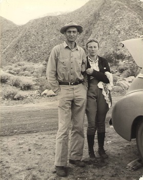 |
11/18/2015
Topic:
Combs Peak Hike
ImpatientHiker
|
Great pics! Looks like you had perfect weather and it's motivating me to get my kids on a trail out there soon. I'd like to try and connect Combs to Toro someday but your pic really shows just how tricky that may be to accomplish.
I'm with Daren, how's your challenge going (nudge, nudge)? |
11/18/2015
Topic:
Santa Rosas / Rockhouse Canyon 4 Day Backpack
ImpatientHiker
|
You guys pulled off another good one! I'm going to be blazing through there right after Thanksgiving, wish I had more time to poke around. My favorite experiences there have been almost aimless over a few days with very memorable morning views-from-tent on a hillside near that water, thanks for the improvements. My buddy still laughs at me for snoozing while backpacking in, of course that was after spending time in Carlies the night before... Can't wait to meet up with you guys out there soon. |
11/23/2015
Topic:
cattlemans shack between smugglers cave and Valley
ImpatientHiker
|
Hi Larry. I remember the shack & it's contents progressively disappearing. Crap I'm get'n old, has it really been gone for more than 20 years?! I remember sneaking around several boulder-loving resident herds of horses with monster-sized leg musculature when the cabin still stood. There is a loop that leaves the main rd towards Smugglers cave and rejoins main rd via a wash to the south (bottom left of your oval). If you drive down that wash and park at the black line of your oval (I believe the rd is blocked off at that point now), you can find the homesite 1/4 to 1/2 mile downstream on the right. Google Earth shows a whole lot of traffic through the cabin site and downwash to the desert. I believe these should be pretty accurate but it's been awhile. 32*37'53.73" 116*05'21.56" If you follow the main wash down a mile or so, you'll find a nice (dry) waterfall with some greenery at the bottom. Have fun! |
11/25/2015
Topic:
cattlemans shack between smugglers cave and Valley
ImpatientHiker
|
You're welcome. That's a great story, you must have many. I'd love to see those pic's. Have a great turkey day out there! |
12/13/2015
Topic:
Tabletop/Trestle/Mortero Palms/Dos Cabezas Spring
ImpatientHiker
|
Hi everybody. I've enjoyed the great TR's on here recently and will post one myself from yesterday as soon as I can write it up. I ran a loop over Tabletop Mtn, tracks to trestle to Mortero Palms to Dos Cabezas Spring, and cross country back to my car at the NE corner of Tabletop Mtn. I had a great time with perfect weather and awesome views covering tough but freshly rained on terrain.
It was when I came across a large Bighorn carcass that my day changed. It didn't take long to realize that it was a very fresh kill with clumps of brush clawed up over it and slobber still wet on the bloody, pierced neck. This ram was as big as me and that cat was planning on coming back! I continuously stumbled and stubbed my toes for many miles through the boulders after that because I sure as hell wasn't looking at the ground anymore!
I'll do a write up soon and include the amazing pictures of this encounter. |
12/13/2015
Topic:
Tabletop/Trestle/Mortero Palms/Dos Cabezas Spring
ImpatientHiker
|
Jim, the spring was a trickle the size of my finger. Same as the last couple times I've seen it, in summer & earlier. Plenty for me to filter the ~12 oz I needed. Some dummies were camping there with their tents right up in the bushes against the spring, had to step on a tent to get to water. Some people have no clue how truly special consistent water is in the desert. I'm usually quite comfortable being going solo, the moment I realized that the sheep (a professional cat-attack avoider) had recently been taken down was not one of them! |
1/25/2016
Topic:
Anza Borrego Site Redo
ImpatientHiker
|
Bob Baran wrote:
I am cleaning out the old database.
I am basically deleting accounts that have not posted anything since a majority are SPAM accounts
Thanks for your patience everyone. 
Thank you guys so much for giving your time and skill to maintain and improve this valuable site!
edited by ImpatientHiker on 1/25/2016 |
2/9/2016
Topic:
Villager Peak trailhead vandalism
ImpatientHiker
|
This is terrible! I think we all worry about ending an outing this way. Hope your buddy didn't lose anything of sentimental value Daren. My condolences as well.
-Robert |
4/13/2016
Topic:
Chimney in Carrizo Gorge
ImpatientHiker
|
I've seen that, I think it's just off the first wash north of the nudist resort. |
6/13/2016
Topic:
To the top of El Cajon Mountain aka "The Beast"
ImpatientHiker
|
4 hours round trip ain't bad! A night hike during a full moon would be nice this time of year with a great view of the lights Of Tijuana & San Diego. If you guys want to step up the adventure factor a bit, I'd be happy to finally meet you and lead you through a full moon point to point from El Monte Park (near the El Capitan reservoir dam) to El Cajon Mtn peak to Wildcat Cyn Rd. I'm guessing it'd take you maybe 30 mins to an hour more than your out & back from Wildcat.
-Robert |
6/14/2016
Topic:
To the top of El Cajon Mountain aka "The Beast"
ImpatientHiker
|
Jim, I also want to see our trails remain open & new ones allowed for all of us (including my kids)and I try to be an active participant in that regard. San Miguel is a prime example of rule flouting helping to close off incredible trails, possibly permanently. I was under the impression that only the parking lot had closed hours as I usually ride my bike there but a search of the county's website shows you are correct. Thanks for cluing me in.
The sunset closure rule for Laguna & Cuyamaca Mtn parking has always irked me because it means that it is effectively against the law to watch a sunset from any of OUR peaks as you'd have to reach your vehicle by sunset.
-Robert |
11/15/2016
Topic:
Election Backpack
ImpatientHiker
|
Great TR & pics! I just happened to be in that area Sunday and was quite surprised to see tracks, they must have been yours. It was a moonlit run Sat night from the PCT at Stephenson Peak down a ridge, across Vallecito Valley, up onto the Sawtooth ridgeline above Agua Caliente, back a short ways towards the Cuyamacas, and down to the valley floor. At that point, I was too tired to continue back up to the PCT so I just curled up and slept for an hour til sunrise when I found myself very close to where I think you camped. I even took a photo of the same view of the Sawteeth as you did. I was pretty surprised by the sheer volume and variety of pottery shards just uphill to the west of your camp. Posted some pics on Instagram @impatienthiker. I think that you had the smarter plan with your routing, timing, and a stop at the Lazy Lizard! Loved the election results story too, who doesn't love a good map!
-Robert |
11/15/2016
Topic:
animal trails vs old Indian Trails
ImpatientHiker
|
Hi sddarkman, I'm certainly no expert but I've found that human trails almost always head towards some sort of landmark, like an outcropping, saddle, old tree stump, or a green patch. They also tend to have fewer loose rocks and more stones flush with the ground. Animal trails tend to disperse and change elevation rapidly at technical or brushy spots while human trails don't often deviate. I always tell my kids that a good trail doesn't turn, so if you think you've lost the trail, ask yourself if you've made any sharp turns recently. Hope this helps.
-Robert |
6/7/2017
Topic:
Rumorosa Baja
ImpatientHiker
|
I used to climb a feature I knew as the "Great White Throne" at the upper reaches of Canyon Tahoe between the late 80's and the mid 90's and this looks like the area behind it. I've always wanted to go back and spend more time exploring that plateau. |
6/13/2017
Topic:
Rumorosa Baja
ImpatientHiker
|
All those canyons to the east are so beautiful and remote with water, granite, and palm groves. I really miss those times and still dream of the pre-drought azure streams and deep pools that were a result of the early 70's hurricanes. I've heard that most are chocked up or shallow now. Last time I went was up Canyon Carrizo and walked right into a massive, multi-grove, pot grow. They burned my car and I haven't been down there since. As a young man, that bug took me two years to build and really meant a lot to me. Funny how material things mean less and less once you have kids and get older... |
6/14/2017
Topic:
Rumorosa Baja
ImpatientHiker
|
Thanks. I envy you the many experiences you must've had down there. Remarkable land to those of us that appreciate desert. |
6/15/2017
Topic:
Rumorosa Baja
ImpatientHiker
|
Yep, oh Baja! You guys must have great tales to tell. Britain, sounds like you're the guy to stick with. Rockhopper, your edits hint at stuff better left unwritten...haha.
I remember a two page National Geographic magazine picture years ago that showed a time-lapse pic of the earth from space that showed the lights of humanities presence and the only two dark places on the globe were Siberia and Baja. |