11/4/2022
Topic:
Tropical Storm Kay aftermath
tommy750
|
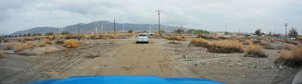
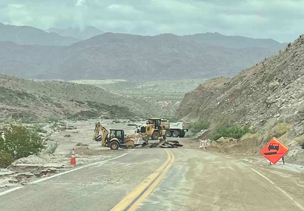
Was out the next day and S2 was washed out with lots of debris still covering every wash that crossed the road. Didn't get any railroad pics but do have a few from the Tropical Storm Kathleen booklet by James L. Larson which is still floating around the internet.
 Rain1 by tomteske, on Flickr Rain1 by tomteske, on Flickr
 Ocotillo Kathleen by tomteske, on Flickr Ocotillo Kathleen by tomteske, on Flickr
 Rain2 by tomteske, on Flickr Rain2 by tomteske, on Flickr
 IMG_0387 by tomteske, on Flickr IMG_0387 by tomteske, on Flickr
 Twist Kathleen by tomteske, on Flickr Twist Kathleen by tomteske, on Flickr
 Bridge Kathleen by tomteske, on Flickr Bridge Kathleen by tomteske, on Flickr
 Myer Kathleen by tomteske, on Flickr Myer Kathleen by tomteske, on Flickr |
11/6/2022
Topic:
Lucia and Alamo Canyon Rock House Ruins 2-3 day BP
tommy750
|
Yoks invited Gary, Randy and me to join him on a 2-3 day BP trip to explore the Chris Lucia rock house mentioned in Rockhopper's post here: http://www.anzaborrego.net/anzaborrego/Forum/topic1386-santa-rosas-prospectors-rock-house.aspx Rockhopper has some nice videos of the area on his YouTube channel. Wade, a friend of the group mentioned another large site up nearby Alamo Canyon and we decided to visit this site as well. After some weather and work related delays, we headed out last weekend. Parking is a bit of a challenge due to private property issues. We ended up parking on Fillmore south of 78th and had no problems. The trail starts as a dirt road and transitions into an apparent wide pack animal route that is braided with an old Cahuilla trail. Gary and Yoks near the trail start:
 IMG_1536 by tomteske, on Flickr IMG_1536 by tomteske, on Flickr
Never seen a trail as heavily ducked as this one but didn't mind it on the way out at dusk. Assuming this is the route used by Rabbit peakbaggers attempting the east approach?
?Nice find at a trail side dump 
 IMG_1532 by tomteske, on Flickr IMG_1532 by tomteske, on Flickr
Randy with the rare rainbow unicorn mylar cluster.
 IMG_1547 by tomteske, on Flickr IMG_1547 by tomteske, on Flickr
Nice pot drop just off the trail.
 IMG_1560 by tomteske, on Flickr IMG_1560 by tomteske, on Flickr
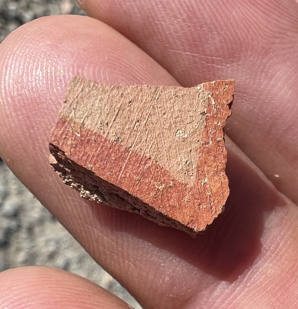
Yoks with a painted sherd.
 IMG_1552 by tomteske, on Flickr IMG_1552 by tomteske, on Flickr
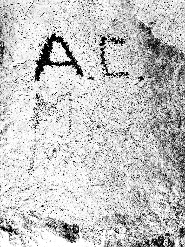
We spent lunchtime near a boulder pile with historical graffiti. Had a hard time even with PS of making out what the faded stuff said.
 IMG_1567 by tomteske, on Flickr IMG_1567 by tomteske, on Flickr
 IMG_1732 by tomteske, on Flickr IMG_1732 by tomteske, on Flickr
 IMG_1568 by tomteske, on Flickr IMG_1568 by tomteske, on Flickr
Nice train intersection! We made a left here.
 IMG_1579 by tomteske, on Flickr IMG_1579 by tomteske, on Flickr
Yoks leading the way.
 IMG_1584 by tomteske, on Flickr IMG_1584 by tomteske, on Flickr
We decided to spend the night on top of this ridge with panoramic views (and cell service).
 IMG_1585 by tomteske, on Flickr IMG_1585 by tomteske, on Flickr
Yours truly after making it up to camp 1 with the lightest pack of the group at 37lb.
 IMG_1587 by tomteske, on Flickr IMG_1587 by tomteske, on Flickr
We hiked down to the Lucia ruins later that afternoon and the next morning. The ruins are on the sloping bench in the center.
 IMG_1592 by tomteske, on Flickr IMG_1592 by tomteske, on Flickr
Gary descending the trail to the ruins.
 IMG_1621 by tomteske, on Flickr IMG_1621 by tomteske, on Flickr
 IMG_1638 by tomteske, on Flickr IMG_1638 by tomteske, on Flickr
 IMG_1597 by tomteske, on Flickr IMG_1597 by tomteske, on Flickr
 IMG_1604 by tomteske, on Flickr IMG_1604 by tomteske, on Flickr
 IMG_1627 by tomteske, on Flickr IMG_1627 by tomteske, on Flickr
Couple broken metates and the base of a beat up obsidian Cottonwood point.
 IMG_1647 by tomteske, on Flickr IMG_1647 by tomteske, on Flickr
 IMG_1652 by tomteske, on Flickr IMG_1652 by tomteske, on Flickr
 IMG_1649 by tomteske, on Flickr IMG_1649 by tomteske, on Flickr
Couple morteros.
 IMG_1605 by tomteske, on Flickr IMG_1605 by tomteske, on Flickr
 IMG_1607 by tomteske, on Flickr IMG_1607 by tomteske, on Flickr
We headed up Alamo Canyon and the trail was pretty obvious the first bit but then kind of disappeared. Fireplace maybe 100ft from the ruins.
 IMG_1669 by tomteske, on Flickr IMG_1669 by tomteske, on Flickr
 IMG_1673 by tomteske, on Flickr IMG_1673 by tomteske, on Flickr
Rock walls are somewhat hard to see in this pic but suspect they are actually a corral.
 IMG_1687 by tomteske, on Flickr IMG_1687 by tomteske, on Flickr
On the way out Sunday afternoon (Randy left early due to not feeling well and Gary and Yoks spent another night) came across a couple boulders with petroglyphs. Rockhopper's videos show two more petro sites I missed.
 IMG_1728 by tomteske, on Flickr IMG_1728 by tomteske, on Flickr
 IMG_1720 by tomteske, on Flickr IMG_1720 by tomteske, on Flickr
 IMG_1723 by tomteske, on Flickr IMG_1723 by tomteske, on Flickr
Made it back to the car in the dark, about 18 miles and a nice start to the backpacking season. Thanks to Yoks, Gary and Randy for the invite. Enjoy!
 IMG_1737 by tomteske, on Flickr IMG_1737 by tomteske, on Flickr
edited by tommy750 on 11/6/2022 |
11/7/2022
Topic:
Lucia and Alamo Canyon Rock House Ruins 2-3 day BP
tommy750
|
Rocko1 wrote:
Really fantastic report. I suspect the ducks are for the Villager east approach. I have always wanted to explore that side of the mountain but the parking logistics always deterred me.
Think we discussed parking more than any other topic prior to the trip. GE has a "trailhead" icon at 80th and Fillmore but 80th has a dirt berm across it and Fillmore south of the E-W drainage channel is heavily signed no trespassing. The only other for sure not private property and not trespassing parking location for hikes to the south eg Salton Sea Petroglyph Trail/Travertine Palms would be at the west end of 86th. Certainly would like to know if anyone else is aware of other legit parking locations. |
11/7/2022
Topic:
Lucia and Alamo Canyon Rock House Ruins 2-3 day BP
tommy750
|
Brian wrote:
Great trip report. I love hearing about areas that aren't in the books. I did Martinez Canyon one time, so I know the parking challenge in that area.
Definitely agree. Looks like someone spent the summer building a 300 acre golf course right near the mouth of Martinez Canyon. Curious.
 Martinez Canyon Golf Course by tomteske, on Flickr Martinez Canyon Golf Course by tomteske, on Flickr |
11/8/2022
Topic:
Lucia and Alamo Canyon Rock House Ruins 2-3 day BP
tommy750
|
Nice find, Rockhopper. We did not find any water below the site. I came up the wash from below and climbed to the top of the white rock dry falls and did not see any water but didn't actually wade through the reeds and catclaw. Yoks crossed over to the mining adit on the other side of the stream bed and didn't see any water either. Think Yoks found some mining claims above the Alamo Canyon site.
Rockhopper, were you able to find any mining activity in either canyon? It seems someone went through a lot of trouble to build that path and rock houses and not have some sort of sizeable mining activity. Thanks for the pics! |
11/8/2022
Topic:
White, Wee, Chimney Rock and Pines
tommy750
|
Nice trip, Rocko1. Have literally never hiked in the NW part of the park. Need to get out more. Found a couple of those blue signs out in McCain Valley a few years ago but they've subsequently disappeared.
 IMG_1070 by tomteske, on Flickr IMG_1070 by tomteske, on Flickr |
11/20/2022
Topic:
Happy cabins and Myer Valley
tommy750
|
Glad to hear the palm groves still have water. Passed by that area over ten years ago while bagging Peak 4004. Didn't know there were rock houses or cultural stuff at that spot. Thanks for the report! |
12/11/2022
Topic:
Elephant Benchmark
tommy750
|
Nice TR. I made it to the bump in the upper left of your second pic a year ago and found cement filled boots in a shelter. There were quite a few healthy looking elephant trees on that side of Alma. As I recall, all the trees seemed about the same size and I didn't seen any "baby" ones which was concerning. Always nice to see the familiar Fish Creek area from a new perspective. Looks like your decent ridge was pretty bouldery. |
12/13/2022
Topic:
Hapaha Flat Thanksgiving Weekend
tommy750
|
Convinced my wife to spend Black Friday driving up Fish Creek rather than facing the marauding hordes of Xmas shoppers. We ended up in the southeastern corner of Hapaha Flat. The weather was perfect the entire weekend. Getting camp set up.
 IMG_1885 by tomteske, on Flickr IMG_1885 by tomteske, on Flickr
The kitchen view looking toward Whale and a sea of ocotillos in red and orange fall colors.
 IMG_1887 by tomteske, on Flickr IMG_1887 by tomteske, on Flickr
Tried to catch a decent pic of the ocotillos lighting up at dusk but a photo doesn't do it justice. Was a really pretty sight.
 Ocotillo Fall Colors by tomteske, on Flickr Ocotillo Fall Colors by tomteske, on Flickr
Lots of cultural sites in the area. Here's a rather large metate fragment.
 IMG_1920 by tomteske, on Flickr IMG_1920 by tomteske, on Flickr
A nice intact Desert Side Notch point.
 IMG_1929 by tomteske, on Flickr IMG_1929 by tomteske, on Flickr
An obsidian drill or an abandoned projectile point a few feet away from the above point.
 IMG_1894 by tomteske, on Flickr IMG_1894 by tomteske, on Flickr
Randy and Lisa, long time Park volunteers found these nice painted sherds a while back. DStretched.
 IMG_2060 by tomteske, on Flickr IMG_2060 by tomteske, on Flickr
Wandering up the wash, we came across this water stash. Was next to the road and only two liters for a June hike? Hope he made it.
 IMG_1968 by tomteske, on Flickr IMG_1968 by tomteske, on Flickr
 IMG_1966 by tomteske, on Flickr IMG_1966 by tomteske, on Flickr
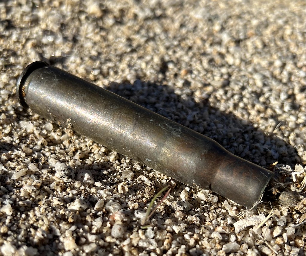
Bunch of shell casings and empty boxes right next to the Hapaha sign. We were planning on cleaning up the mess on our way back but ended up returning by another route.
 IMG_1911 by tomteske, on Flickr IMG_1911 by tomteske, on Flickr
 IMG_1917 by tomteske, on Flickr IMG_1917 by tomteske, on Flickr
Desiccated Chuckwalla
 IMG_2044 by tomteske, on Flickr IMG_2044 by tomteske, on Flickr
 IMG_2051 by tomteske, on Flickr IMG_2051 by tomteske, on Flickr
Found a faint trail on GE I tried to follow on the final day. Was very rocky and eroded. About a mile in, came across this unfortunate ram.
 IMG_2008 by tomteske, on Flickr IMG_2008 by tomteske, on Flickr
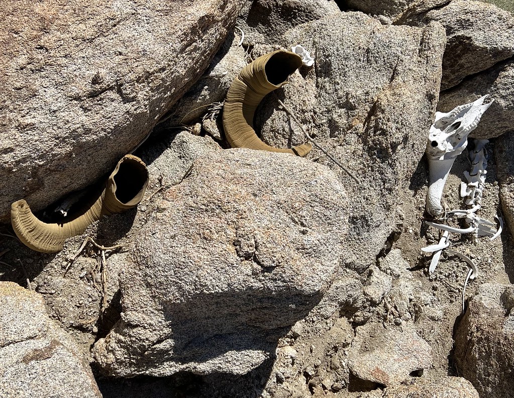 IMG_2010 by tomteske, on Flickr IMG_2010 by tomteske, on Flickr
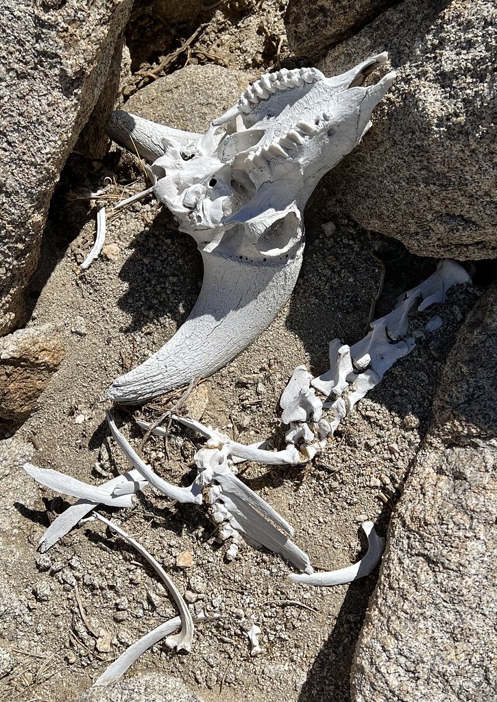 IMG_2015 by tomteske, on Flickr IMG_2015 by tomteske, on Flickr
Nice view of the Carrizo badlands toward Canebrake and McCain.
 IMG_2022 by tomteske, on Flickr IMG_2022 by tomteske, on Flickr
Large drilled rim sherd in the middle of the trail.
 IMG_2029 by tomteske, on Flickr IMG_2029 by tomteske, on Flickr
 IMG_2033 by tomteske, on Flickr IMG_2033 by tomteske, on Flickr
On our way out, lots of nice desert sand-verbena were blooming.
 IMG_2055 by tomteske, on Flickr IMG_2055 by tomteske, on Flickr
Literally 30 seconds before the canyon turned to gray. A little hiking, a little exploring and a lot of relaxing. Enjoy!
 IMG_2059 by tomteske, on Flickr IMG_2059 by tomteske, on Flickr |
12/14/2022
Topic:
Hapaha Flat Thanksgiving Weekend
tommy750
|
Brian wrote:
How was the road condition going up to Hapaha from Sandstone? I've done it in my Crosstrek, but it seems like all the roads got slammed this summer and are in worse shape than normal.
There's always been that one 20 ft sketchy spot when you're exiting the canyon after Olla and before Hapaha. It got way better after they ran a dozer through there a few years ago but it's icky again. Had my wife get out and help me dodge boulders on the way in and heard a few too many scrapy sounds on the way out. Don't think you'd have any problems with any other location. Hope that helps! |
12/14/2022
Topic:
Salton Sea to Lake Cuyamaca-SDTCT
tommy750
|
Must be nice to be young and fit! Great trip. Your Plum tent/moon pic is really trippy. Like it. |
12/14/2022
Topic:
Hapaha Flat Thanksgiving Weekend
tommy750
|
dsefcik wrote:
Very Nice tommy750...!!!!  Remember our first camping trip ever was up the road at Dave McCain? In 2013, Xmas break. How time flies. Appreciate all the memories!
 Daren by tomteske, on Flickr Daren by tomteske, on Flickr |
12/14/2022
Topic:
Hapaha Flat Thanksgiving Weekend
tommy750
|
Brian wrote:
tommy750 wrote:
Brian wrote:
How was the road condition going up to Hapaha from Sandstone? I've done it in my Crosstrek, but it seems like all the roads got slammed this summer and are in worse shape than normal.
There's always been that one 20 ft sketchy spot when you're exiting the canyon after Olla and before Hapaha. It got way better after they ran a dozer through there a few years ago but it's icky again. Had my wife get out and help me dodge boulders on the way in and heard a few too many scrapy sounds on the way out. Don't think you'd have any problems with any other location. Hope that helps!
That does help, thanks. If you're scraping with your truck I'm going to assume it isn't Subi-friendly at the moment. When I went in before I had a similar experience as you described. Made it past that section with some care going in, but on the way out dropped off a rock and hit my skid plate hard.
Dug up a couple pics from before and after the dozer. I would say it's worse than the pre dozer pic now.
 Upper Fish Creek Squeeze (2018_09_25 07_05_23 UTC) by tomteske, on Flickr Upper Fish Creek Squeeze (2018_09_25 07_05_23 UTC) by tomteske, on Flickr
 After the dozer by tomteske, on Flickr After the dozer by tomteske, on Flickr |
12/16/2022
Topic:
Hapaha Flat Thanksgiving Weekend
tommy750
|
Buford wrote:
Very nice. Good to see all the sand verbena in bloom already. I'd be almost afraid of all the vehicles in Fish Creek in a holiday weekend as black friday. Do most stop well short of Hapaha flat?
I can't believe how many points you find.
We were worried there were going to be a zillion campers out there but it was really quiet compared to just about any other weekend. We had a group of jeeps go by about every hour or two but nothing like the traffic farther down canyon. It is 15+ miles to Hapaha one way, so probably less traffic. Really nice area. With the points, it's a matter of patience. Pretty sure you, with your awesome wildlife and time lapse photography, know all about that! |
12/24/2022
Topic:
2022
tommy750
|
NIce pics Buford! Really like the BW of the ramp. A review of the Nikon P1000 popped up in my youtube feed and I thought of all your bird pics. Not sure how good it is but sure looked like fun. Thanks! |
1/1/2023
Topic:
Stone Circle
tommy750
|
Not able to see your pics, Britain. |
1/11/2023
Topic:
2023 ABDSP and surrounding areas
tommy750
|
Very nice! Thanks. |
1/11/2023
Topic:
first desert weekend of 2023
tommy750
|
Rocko1 wrote:
Very cool. Have those pictographs been touched up at some point?
Pretty sure those have been touched up. Up close the black "pigment" looks more like liquid asphalt. Rumors abound about the identity of the touch-up artist. There are a few other altered sites in the Anza Borrego area including Little Blair Valley, the Blue Sun Cave and most likely another site in Indian Hill, again, with lots of black pigment over very faded red and yellow pictos. The site high up in Potrero is another example reportedly touched up by a local rancher.
Not sure why it's done, but apparently it's not just a local phenomenon. On a prior trip a speck east of here, I was surprised to see artists overpainting a faded Greek fresco at Ephesus presumably to make it more tourist friendly. As they say, the more popular an archaeological site, the less authentic.
 Ephesus Restoration by tomteske, on Flickr Ephesus Restoration by tomteske, on Flickr |
2/9/2023
Topic:
White Whale/Pinyon
tommy750
|
Very nice, Rocko 1! A favorite hiking memory is descending Whale some years ago while it lightly snowed. Very serene. |
3/14/2023
Topic:
Bisnaga Alta to Near Whale Peak
tommy750
|
Haven't been up Whale in quite a while but always wanted to explore the flats to the east and southeast. Figured I'd try the Bisnaga Alta route, a southern approach I first head about on this forum when Daren did it in 10/2011. Unfortunately the pics are no longer hosted but Daren sent me his route which was a way tougher loop hike. Googled the route and even looked at the last 50 or so PeakBagger gps entries and zero hits for the Bisnaga route.
 123_1 by tomteske, on Flickr 123_1 by tomteske, on Flickr
Was a cool somewhat cloudy day and very windy near the top. A look back at the Sawtooth spine about two miles up Bisnaga Alta wash.
 Sawtooth Spine by tomteske, on Flickr Sawtooth Spine by tomteske, on Flickr
Still a little snow on at least the north facing Lagunas.
 Nine Miles Away by tomteske, on Flickr Nine Miles Away by tomteske, on Flickr
Was assuming the route was not that popular but noted fresh vehicles tracks at the Bisnaga turn out and two sets of prints heading up/down the wash maybe the first 3-4 miles. At about mile 3, a third set of prints appeared. Here they are with better lighting on the descent, size 14 boots for scale. Not sure where the two hikers went but didn't see anymore of their prints.
 IMG_2979 by tomteske, on Flickr IMG_2979 by tomteske, on Flickr
 IMG_2982 by tomteske, on Flickr IMG_2982 by tomteske, on Flickr
Nice succulent.
 IMG_2923 by tomteske, on Flickr IMG_2923 by tomteske, on Flickr
Thought I spotted a native trail heading out of the flat above Bisnaga Alta on GE and maybe found bits of it. Here's a rather well preserved section.
 IMG_2945 by tomteske, on Flickr IMG_2945 by tomteske, on Flickr
The view toward the flat.
 IMG_2942 by tomteske, on Flickr IMG_2942 by tomteske, on Flickr
Found a dozen or so roasting pits on the way up and with the sun fading, kinda quit counting on the way down. Some are almost easier to see on GE. Here's RP-8 and the view from space. You can even see the slick on the boulder from the satellite image (red arrow)
 IMG_2949 by tomteske, on Flickr IMG_2949 by tomteske, on Flickr
 RP-8 by tomteske, on Flickr RP-8 by tomteske, on Flickr
Another roasting pit a bit farther up.
 IMG_2952 by tomteske, on Flickr IMG_2952 by tomteske, on Flickr
 RP-10 by tomteske, on Flickr RP-10 by tomteske, on Flickr
At the top there were a lot of downer trees looking like they'd been ripped out of the ground and tossed presumably by some ferocious winds.
 IMG_2954 by tomteske, on Flickr IMG_2954 by tomteske, on Flickr
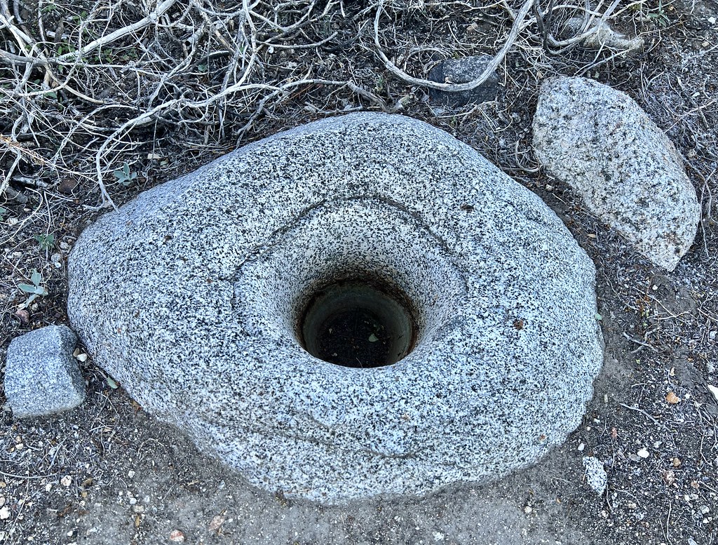
Explored around one of the flats and found a couple rock shelters with cultural stuff. Nice mortero and pestle.
 IMG_2956 by tomteske, on Flickr IMG_2956 by tomteske, on Flickr
Didn't spend as much time as I'd hoped exploring the flats since I wanted to get down to the wash before dark. Here's a historical .50 cal artifact a long way from the Carrizo Impact Area.
 IMG_2973 by tomteske, on Flickr IMG_2973 by tomteske, on Flickr
 IMG_2974 by tomteske, on Flickr IMG_2974 by tomteske, on Flickr
A little less that 13 miles and about 3700 ft g/l. Another nice day in the desert. Enjoy!
 IMG_2984 by tomteske, on Flickr IMG_2984 by tomteske, on Flickr |
3/15/2023
Topic:
Bisnaga Alta to Near Whale Peak
tommy750
|
ziphius wrote:
Good-looking trip Tom. That pestle is the largest I've seen out there. I miss the Sawtooth spine, spent the better part of a day kicking around up there once. Amazing what you can detect for confirm from satellite imagery. Once saw two bighorn rams side by side, drinking at a guzzler on satellite.
I still remember your pic of the two sheep! That was a nice find. |
3/15/2023
Topic:
Bisnaga Alta to Near Whale Peak
tommy750
|
surfponto wrote:
Some beautiful desert backcountry. Looks like you had great weather
Was nice and cool but a speck breezy for my taste. Still went through 3 liters. |
3/15/2023
Topic:
Bisnaga Alta to Near Whale Peak
tommy750
|
Brian wrote:
That's an ambitious route for a dayhike. I love seeing reports of routes that are rarely visited. Nice to know there are a few of those left.
Definitely like backpacking for that reason, much more loiter time to explore since no pressure to get back home. |
3/15/2023
Topic:
Bisnaga Alta to Near Whale Peak
tommy750
|
Rocko1 wrote:
Very nice! Can you explain how a roasting pit differs from say a plain old clearing? I have come across many areas that are cleared of most plant life and rocks but was never sure if was by chance or a real pit.
A roasting pit is going to have fire affected rocks (usually gray/black/sometimes reddish colored) along with ashy soil. They're often on mountain ridges and can be rather pristine or eroded away. If you come upon a nice rock circle of "FAR" filled with a deep layer of ash, it's pretty obvious. Sometimes the rocks are disorganized and the grey ash layer is covered with sediment or overgrown by plants. Have to say my examples of roasting pits are pretty beat up. Daren's trick is to trench the soil layer with your boot heel and see if it reveals the gray soil. |
3/16/2023
Topic:
Bisnaga Alta to Near Whale Peak
tommy750
|
tekewin wrote:
Very impressive trip! I don't think I've seen that route before, but wasn't on the forum back in 2011.
You really have an eye for native artifacts. I'm sure I walk by treasures all the time in complete ignorance.
Was a casual weekend peakbagger till stumbling on this forum a decade ago and realizing everyone here had a real curiosity of the fauna/flora/geology/artifacts around them. Seems obvious, but have to say it really changed my perspective. Thanks everyone! |
8/3/2023
Topic:
The Santa Rosas Sawmill Trail (Sort Of)
tommy750
|
This interesting video showed up in my youtube feed about Desert Steve Ragsdale and I thought I'd pass it on. Wasn't aware he founded Desert Center before retiring to the Santa Rosas. Enjoy: https://youtu.be/XqGNFJRAtwg |
8/13/2023
Topic:
The Santa Rosas Sawmill Trail (Sort Of)
tommy750
|
Brian wrote:
tommy750 wrote:
This interesting video showed up in my youtube feed about Desert Steve Ragsdale and I thought I'd pass it on. Wasn't aware he founded Desert Center before retiring to the Santa Rosas. Enjoy: https://youtu.be/XqGNFJRAtwg
Great video, thanks. Too bad they didn't show more of Santa Rosa MTN, but I guess that wasn't the topic of the video.
Agree. Going to try an camp out at the top in the next weeks weeks and do a few day hikes with the spouse. |
11/20/2023
Topic:
Crowds
tommy750
|
I guess the upside would be at least more people are interested enough in visiting and exploring our federal and state lands. Hopefully that will translate into wanting to preserve and protect them.
My "workaround" as an old guy is to retire soon and visit the park only during weekdays. Also, get one of those parking permits for volunteering 40 hours a year. Not sure if it will work at the slot which I'm not familiar with, but at least it will get you into the visitor center.
BTW, has anyone read the wikipedia entry for the park? I learned that obsidian, pumice and fish bones are "artifacts." Cupule petroglyphs suggest food processing was hard. To get from the coast to the park, you drive through mountains that are 2,400 feet above sea level. All good stuff to know! |
1/13/2024
Topic:
Tesla Cybertrucks tearing up Anza Borrego Desert
tommy750
|
If you look back on Google Earth, this area has been pretty beat up for > 10 years. Here's a view from > 7 years ago and looks like the Cybertruck is not disturbing pristine ground. Kinda looks like the mess at Diablo drop off. I certainly get what you're saying though, Surfponto.
 cybertruck by tomteske, on Flickr cybertruck by tomteske, on Flickr
edited by tommy750 on 1/13/2024 |
2/16/2024
Topic:
Four Frogs Canyon
tommy750
|
Nice trip, Surfponto. Driving out on a Tuesday to explore a canyon, drink a beer and drive home makes me want to quit my job right now! Daren, Gary and I went up Jacumba Jim back in 2017 and I remeber dropping into Four Frogs on the way back but haven't had a chance to explore that canyon. That row of palms on the canyon wall always has looked intriguing. Was out in Rockhouse a couple weeks ago and hiked up into McCain and above the spring that fed Rockhouse. Was aboout 11.5 miles and 2.6K g/s but probably easier than the Schad Four Frogs Jacumba Jim loop. |
2/16/2024
Topic:
Little Blair North
tommy750
|
Another nice trip. Glad you like your new tent. Was watching a youtuber last night review "ultralight tents' and zpacks didn't make the cut (the guy's sponsor was Moosejaw, so...) but it would have been the lightest of all of them. Thought zpacks way more pricy than the competition but that's not really the case anymore. Quite happy with my altaplex. Thanks! |
2/16/2024
Topic:
Sandstone Canyon question
tommy750
|
Nice find. Only issue I would have is what they're painted on. The last Kumeyaay (and Cahuilla) visited Hapaha just up the wash in the 1890's and I would wonder if it would last that long on exposed sandstone. The visitor grafitti etched into the neaby rocks seems to fade rather quickly but there's lots of paint on sanstone like stuff in Utah so who knows. Will see if anyone at BARC has seen that. |
2/16/2024
Topic:
My Retriement
tommy750
|
Well Daren, glad you were able to escape the grind! Can't say I don't miss you, though. Honestly have to say essentially everything I've learned in the past 10+ years about hiking/backpacking/the desert I owe to you. Thanks for the great memories and hoping you can make it out here again some time. |
2/26/2024
Topic:
Sandstone Canyon question
tommy750
|
That's pretty clean! Wonder if a park volunteer helped it along. |
15 days ago
Topic:
Pinyon Wash to Harper Cabin
tommy750
|
Nice TR, Surfponto! I feel your pain regarding the Marines flying stuff overhead. I live five miles away from El Centro NAF and see/hear/feel their big birds at all hours of the day including midnight. The Blue Angels practice here every winter and 5-6 F-18s flying overhead makes your ears ring. Have never visited Harper Cabin. Glad to hear it's surviving. Agree, Pinyon wash is a great camping spot and great starting off point for lots of hikes to Sunset, the four nearby guzzlers, Pinyon Mt, Whale, Harper Flat. Was out at Split Rock a couple months ago and met hikers coming in from Pinyon to check out the pictographs. |
15 days ago
Topic:
Middle Ysidro
tommy750
|
I've never even heard of Middle Ysidro but looks like a great day hike. Glad you were able to recover from your ankle injury and keep going. |
15 days ago
Topic:
Panamint City
tommy750
|
Nice trip, Brian! A quote from the NPS site: "Panamint City was called the toughest, rawest, most hard-boiled little hellhole that ever passed for a civilized town. Its founders were outlaws..." |
14 days ago
Topic:
Pinyon Wash to Harper Cabin
tommy750
|
Brian wrote:
tekewin wrote:
Those blooms are amazing. Sounds like a successful trip and kudos for being kind to the biker.
Is the road OK all the way to Harper Flat or even Hapaha Flat? I've only been down that road a little ways to hike to Sunset Mountain.
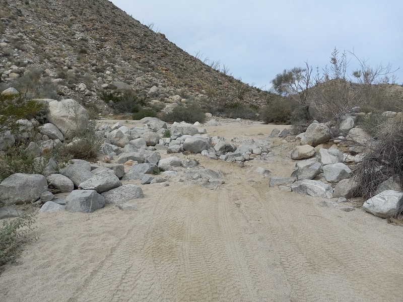
That road ends at a canyon which is a short hike up to Harper Flat. The road that passes Harper Flat on the other side can be accessed 2 ways. One end goes in from Pinyon Mountain Road (which necessitates negotiating the squeeze and heart attack hill). The other end goes in from Fish Creek and passes through Hapaha Flat. The biggest obstacle I know of on that route comes just before you get to Hapaha and looks like this:
It's no longer legal to drive through Harper Flat (despite the fact someone did it last summer and was later found dead).
edited by Brian on 4/12/2024
Definitely right, Brian. That's always been the fun spot to squeeze through although I thinks someone moved a few rocks from the right side that made it a speck easier in the past couple months at least for my pickup.
Speaking of the ex-Navy Seal found dead in Harper Canyon, was wondering when someone would mention it on the forum. Here's a couple news reports if anyone is not familiar with the story:
https://www.youtube.com/watch?v=WlW6PfpO1og
https://www.youtube.com/watch?v=xZDzp74oj1w
I bumped into a knowledgeable source who mentioned the Tacoma was airlifted out of Harper Flat since it was pretty beat up. Assuming we'll never hear what really happened but a very tragic story.
Was able to find the Tacoma location on GE and the news reports gave info on where the individuals were located.
 Seal Woman and Tacoma (1) by tomteske, on Flickr Seal Woman and Tacoma (1) by tomteske, on Flickr
Gary and I walked out there a while back and found ?helo landing gear imprints in the sand but no other vehicle tracks. Didn't have the Tacoma location at the time but apparently walked within twenty feet of its prior location and didn't see anything.
 IMG_6515 by tomteske, on Flickr IMG_6515 by tomteske, on Flickr
 Track by Tacoma by tomteske, on Flickr Track by Tacoma by tomteske, on Flickr |