|
hikerdmb Posts: 423
3/5/2012
|
My plan was to backpack into Rockhouse Valley and search for the remains of the Santa Rosa Indian Village. I found lots of conflicting information on its location so I decided I would head for one of the two areas I suspected held the remains. I looked on google earth and matched up what I thought was the remains of a circular house at about 4,000' at the base of Toro Peak. Everything seemed to match up when planning from home that I would find what I was lookiing for. But alas, I found nothing. However I had a great hike and night out in a very lonely corner of ABDSP (really I started the hike in ABDSP but most of the hike is outside the park boundary).
I woke up at 5:00AM and finished packing and had the DesertTJ on the road by 7:00. Once I left pavement near Clark Dry Lake it still took almost an hour to reach the end of the road in Rockhouse Canyon. I started hiking around 10:00 AM under clear skies with just a bit of a breeze.
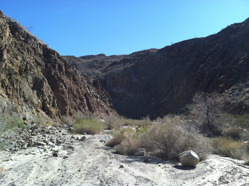
I ran into 3 packers coming down by the dry fall right at the county line. These would be the only people I saw during my hike. Near the dry falls the walls of the canyon are very steep and colorful with lots of huge boulders on the floor.

Walking through the canyon the sand was hard like cement all the way into Rockhouse Valley. There must have been some rain in the area to make the sand hard like this but there wasn't much green in the area. After about 90 minutes I made it to the edge of the valley. Here is the first view of Toro Peak.

When you enter the valley you can find the 3 lower rock houses (not really houses, more like walls) on the right about half a mile or so up the wash on the west side of the valley. The lowest rock house is in bad shape but the middle and upper houses are in much better shape. There was lots of rodent droppings in the walls so I don't think I would stay in them. Here is the middle house. You can just see the upper rock house over the wall of the closer house.

After a nice long lunch break I started off up an un-named wash toward where I hoped I would find some ruins. The moon rose over the Santa Rosa Mountains as I clmbed the next 1000' up to a bench overlooking the valley.

Here is the view looking up the wash toward Toro Peak.

When I reached 4,000' I left the wash I climbed up to look for the ruins I was hoping I would find. The vegetation was pretty thick and I didn't see any signs of the circular house I was hoping to find. I did however come across and old trail with some ducks so I followed it up hoping it would lead me to the ruins. I climbed up to almost 4,600' before deciding this trail led over into the canyon where a seep is located. The pictures I had seen of the ruins show them much lower than where I was so I turned around and descended back to around 4,000' to look some more and camp. As the sun began to set I found a nice campsite and set up. Here is the view back down toward Rockhouse Canyon from my site. Once the sun set I could see the lights of El Centro through the low spot and the end of the valley.

Here is a photo looking east as the sun was setting. This is the other place in the valley where I plan to return and check out for ruins.
It was a very peaceful night with just a slight breeze. It did get down into the upper 30's but without any wind it was pretty good sleeping, although the moon was quite bright. But after the drive out and then hiking 8+ miles and gaining 2,600' of elevation I slept like a baby. I may have snored but there was nobody within miles of me to complain. Here is a pic of my spartan campsite with Buck Ridge in the distance.

I got up early on Sunday morning and spent about an hour searching one last time for the ruins still with no luck. So I packed up and was heading downhill by 7:15. It was going to be hot and I wanted to get back into the shade of the canyon before it got too hot. It was a pretty uneventful 3 hour hike back to the jeep. No mylar balloons to add to Daren's total but I did come across a regular balloon. It was not there the day before and it was still very bright purple.

Even though I did NOT find the ruins I was looking for it was a very great hike. And now I have a reason to go back and search in other parts of the valley. Here is a google earth of my route. You can see where I detoured off to visit the lower rock houses and also where I left the wash to climb up and search for the ruins up toward the top of the image.

<em>edited by hikerdmb on 3/5/2012</em>
|
|
|
link
|
|
dsefcik Administrator Posts: 2634
3/5/2012
|
looks fun..I have not been there (yet) but I think maybe you needed to go north west a bit more up to the top of Nicholias Cyn. I believe there are more ruins east of there also. I have been wanting to do this trip for a couple years now, maybe over Spring Break.
<em>edited by dsefcik on 3/5/2012</em>
--
http://www.sefcik.com
http://www.darensefcik.com
http://www.carrizogorge.com
|
|
|
link
|
|
surfponto Administrator Posts: 1369
3/5/2012
|
Nice David,
GreatTR
I have day hiked to the lower rockhouses in Rockhouse Valley but have not gone as far as the village.
Looks like you had some great weather.
You must have a good bag since the temps were in the 30s
I have found some references to the old village so we will have to compare notes,
Bob
--
https://www.anzaborrego.net/


|
|
|
link
|
|
DHeuschele Posts: 87
3/6/2012
|
One of the desert magazines has a crude hand drawn map of many of the ruins. I have looked at the map and find it a little confusing as something seemed wrong at the time but I do not remember what it was right now. If I remember when I get home I will look for it and post a reference.
Schad Rockhouse loop map also has the location of 2 separate rockhouse sites but I do not know if either is the one that you could not find.
I am signed up to do a backpack in Rockhouse Canyon in 2 weeks. It is via a meetup group. The description states 20 miles which is close to the Schad Rockhouse hike so I suspect it may be somewhat the same as the Schand hike . I will be just going where the leader has planned but I will bring the map from the Desert magazine and if I have any energy I may do some additional exploration.
The backpack will be a little heavy with water (but should not be heavy as my last ABSP backpack when I carried water for some kids - See my Domelands trip report from Sept?), I am thinking 8 qts as nothing is worse than running out of water.
|
|
|
link
|
|
bobmc Posts: 7
3/6/2012
|
I have visited the upper rockhouses. They are pretty much where Schad's map shows them. The trick is locating the drainage which even when you are in it has several sub washes. The houses are scattered along the foothills to the left of a large mesa against the mountains they are at several elevations. One of the people who went with me said there was one further east also. I am leading the trip mar 17 to find the ones in Nicolas canyon and maybe look at the mining ruins also. We will also visit the other rockhouses in the valley. Maybe go to the petroglyphs if we have time.
|
|
|
link
|
|
anutami Posts: 491
3/6/2012
|
I love going out to RockHouse road. Been out on the jeep trails but never hiking. It is so isolated. Isn't pegleg smith gold rocks supposed to be somehwere around that area?
|
|
|
link
|
|
DHeuschele Posts: 87
3/7/2012
|
bobmc wrote:
I am leading the trip mar 17 to find the ones in Nicolas canyon and maybe look at the mining ruins also. We will also visit the other rockhouses in the valley. Maybe go to the petroglyphs if we have time.
So I bet the trip I am going on in 1.5 weeks is with you :=). I hope it is not hot.
The desert magazine that has the poor map of the rockhouse info is the Jan 1968 magazine "The Rock House Mystery in Anza-Borrego" . Map is on p 13. There are 4 rock house locations on the map and a 5th point that is not specifically mentioned by the point name in the article but I suspect is the petroglyphs near the seep spring. One of the things that bothers me about the map is that it seems to indicate that the rock house locations are 2 miles East of Hidden Spring. Unless there is another "Hidden Spring" this does not jive with other info that I have seen (I knew there was something about the map that I thought did not seem correct just could not remember what it was).
|
|
|
link
|
|
bobmc Posts: 7
3/8/2012
|
Dan, Ha ha. I went and looked at the map you were talking about. It is pretty hilarious. I believe the photos are of the rockhouses by the entrance to the valley. The map is horribly out of proportion and scale. I believe that the petroglyphs they were talking about are the ones at Clark dry lake. which are roughly two miles east of hidden spring. We will be starting early and gain elevation quickly so if it is warm We should be high enough and far enough along to avoid the worst of it. There is also a Sierra club/WBC group going out that weekend but they are starting much later.
|
|
|
link
|
|
DHeuschele Posts: 87
3/16/2012
|
Unfortunately the Rockhouse Canyon backpack trip planned for this weekend has been cancelled due to the rain forecast (more specifically the mud that results from rain).
Also my backup hike for this weekend (Whale Peak) also was cancelled due to the weather forecast.
I had thought of a Baldy climb but I suspect the drive and conditions on the mountain will be bad.
Looks like it will be a honey-do weekend for me. Unfortunately it is the only weekend until early June that I had pretty much free to hike, backpack, etc. I will need to see if can move something to allow at least one more backpack this desert season.
|
|
|
link
|
|
surfponto Administrator Posts: 1369
3/16/2012
|
Probably a good idea to cancel
Have heard we are suppose to get a lot of weather Saturday
I heard the snow level may be down to 2500 feet in San Diego
DHeuschele wrote:
Unfortunately the Rockhouse Canyon backpack trip planned for this weekend has been cancelled due to the rain forecast (more specifically the mud that results from rain).
Also my backup hike for this weekend (Whale Peak) also was cancelled due to the weather forecast.
I had thought of a Baldy climb but I suspect the drive and conditions on the mountain will be bad.
Looks like it will be a honey-do weekend for me. Unfortunately it is the only weekend until early June that I had pretty much free to hike, backpack, etc. I will need to see if can move something to allow at least one more backpack this desert season.
--
https://www.anzaborrego.net/
|
|
|
link
|
|
DHeuschele Posts: 87
3/16/2012
|
surfponto wrote:
Probably a good idea to cancel
I know but I am still a little disappointed. I have wanted to do a fairly thorough trip into that area for a while and this trip fit on my calendar.
I really do not have too much to complain about. This desert season I have done a backpack in ABSP (Domelands area), a day hike of the Blair Valley area (including a petroglyph site I had not known about), a very thorough trip to DV including a summit of Telescope Peak (we pretty much did all the highlights in DV except Saline Valley area (hot spring, sand dunes, etc.), a trip of the South Utah parks (including Zion, Bryce, Escalante, Capitol Reef, Monument Valley) and a hike up Pima Canyon (Tucson). Plus in early June I have a Grand Canyon rim to rim (North to South) planned. Lots of desert trips this season and quite a bit of variety.
Still a Rock House Canyon trip would have been the icing on the cake :=). Whale Peak would have been an OK alternative (I like Whale Peak but I have done it which is what I meant by OK alternative, it is a great desert peak).
|
|
|
link
|
|
billd987 Posts: 6
3/18/2012
|
Thanks for sharing.
I've got Rockhouse Valley on my to do list. It's one place I've never been to in the park.
|
|
|
link
|
|
surfponto Administrator Posts: 1369
3/21/2012
|
It's a great area that you could spend a week exploring. Lots of open space and things to see.
I am hoping to do a backpack trip out there at some point also.
billd987 wrote:
Thanks for sharing.
I've got Rockhouse Valley on my to do list. It's one place I've never been to in the park.
--
https://www.anzaborrego.net/
|
|
|
link
|