|
dsefcik Administrator Posts: 2634
5/3/2010
|
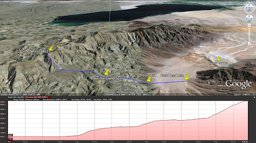
I have a gps track planned out for peak 6582 based on Jerry Schads book. See Google Earth image below.
This could be a 2 day backpack or a very long single day trip. Anybody interested in trying this out?
Daren
<em>edited by dsefcik on 11/9/2010</em>
--
http://www.sefcik.com
http://www.darensefcik.com
http://www.carrizogorge.com
|
|
|
+1
link
|
|
surfponto Administrator Posts: 1369
5/3/2010
|
Hey Daren,
I would be interested.
What is the distance on that?
Bob
--
https://www.anzaborrego.net/


|
|
|
link
|
|
dsefcik Administrator Posts: 2634
5/3/2010
|
Jerry Schad's book lists it as 12 miles with a 5 star rating, the highest given in his book. You will ascend 3,000' feet in 1 mile from the bottom of the peak to the top. That also means a descent of 3,000'. There was snow up there during spring break..so at almost 7,000' it can be cold.
My personal take is one of the following:
1. Drive out to the start point and camp over night, leave early in the morning and hike it all in one day, camp the night again at the parking spot and drive home on the 3rd day.
2. Drive out, hike to a camp spot in one day, hike the peak the second day, return to parking spot and drive home late(this is what Jerry recommends).
3. #2 but camp overnight at the parking spot and drive home the 3rd day.
I kinda like #1 and you can carry water out to the half way point and refill on the way back. This also provides some comfort of a base camp with "all the amenities". Depends on your perspective I suppose.
Daren
surfponto wrote:
Hey Daren,
I would be interested.
What is the distance on that?
Bob
--
http://www.sefcik.com
http://www.darensefcik.com
http://www.carrizogorge.com
|
|
|
link
|
|
dsefcik Administrator Posts: 2634
5/3/2010
|
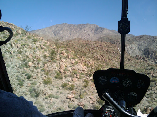
I should probably also add that from the helicopter tour of Anza Borrego it looked pretty rugged.
Here is a pic coming up out of the dry lake area and looking towards the peak:
edited by dsefcik on 5/3/2010
<em>edited by dsefcik on 11/9/2010</em>
--
http://www.sefcik.com
http://www.darensefcik.com
http://www.carrizogorge.com
|
|
|
link
|
|
surfponto Administrator Posts: 1369
5/4/2010
|
I would be interested depending on the date.I like option one also.
The terrain looks similar to when Mary and I bushwhacked up Sombrero Peak
Bob
--
https://www.anzaborrego.net/
|
|
|
link
|
|
dsefcik Administrator Posts: 2634
5/7/2010
|
How about May 21,22 & 23rd?
--
http://www.sefcik.com
http://www.darensefcik.com
http://www.carrizogorge.com
|
|
|
link
|
|
dsefcik Administrator Posts: 2634
11/9/2010
|
So right now, today, I think this will be my trip out this weekend. I am gonna leave Friday morning, hike out to a potential campsite, hike to the peak on Saturday and finish the trek back to the truck by the end of Saturday. Big fire and beer Sat night and drive back home Sunday.
Daren
<em>edited by dsefcik on 11/10/2010</em>
--
http://www.sefcik.com
http://www.darensefcik.com
http://www.carrizogorge.com
|
|
|
link
|
|
surfponto Administrator Posts: 1369
11/10/2010
|
Hey Daren,
I would be interested but it its Mary's birthday weekend so....
Actually thinking of camping Thursday night in Mount Laguna for her B day.
Your trip sounds great though.
Bob
--
https://www.anzaborrego.net/
|
|
|
link
|
|
dsefcik Administrator Posts: 2634
11/10/2010
|
Hey, no problem Bob, give Mary a "Happy B-day" for me..!
I am also looking at a Sheep/Palm/Cougar Canyon loop instead..will have to decide soon.
Camping at Laguna should be nice, not sure where you go but Cibbets Flats ( http://www.fs.fed.us/r5/cleveland/recreation/camping/cibbetsflats.shtml) is a nice small, lower elevation site I like with access to the PCT for lots of hiking.
Daren
edited by dsefcik on 11/10/2010
<em>edited by dsefcik on 11/10/2010</em>
--
http://www.sefcik.com
http://www.darensefcik.com
http://www.carrizogorge.com
|
|
|
link
|
|
surfponto Administrator Posts: 1369
11/10/2010
|
Thanks for the tip.
We will check it out.
Going to drive up and see what's available.
Bob
--
https://www.anzaborrego.net/
|
|
|
link
|
|
6kmclimber Posts: 13
12/19/2010
|
dsefcik,
I like what you do with Google earth. Add that to the list of things I need to learn to do.
Did you climb peak 6582? That looks like an awesome trip. I have been wanting to go to the "corp"
petroglyhs for some photos and head higher up for a look see. Looks like trip #2 would be my favorite.
|
|
|
link
|
|
surfponto Administrator Posts: 1369
12/21/2010
|
OK you have my interest :-)
What are the "corp" petroglyphs?
Bob
--
https://www.anzaborrego.net/
|
|
|
link
|
|
dsefcik Administrator Posts: 2634
12/21/2010
|
When you cross Clark Dry Lake there is an old engineering marker "Corp" (it is also on topo maps) and it has some glyphs there. It is also mentioned in Schads book.
I have not made it out yet, I was gonna go out to Rockhouse Cyn this week but th weather has derailed that plan. I will try to go after Christmas.
surfponto wrote:
OK you have my interest :-)
What are the "corp" petroglyphs?
Bob
--
http://www.sefcik.com
http://www.darensefcik.com
http://www.carrizogorge.com
|
|
|
link
|
|
DHeuschele Posts: 87
6/8/2011
|
I am interested if you did this hike. If I had seen this earlier I may have been interested but I have been too busy and did not do a single ABSP hike/backpack this season.
I have done 6582 twice, once using the Schad (who is very sick) route and once from Rock House Canyon. Rock House Canyon is the eaiser route especially if you have a high clearance vehicle that can make it far up the road (we took a camper and did not make it that far up the road).
The petrogylphs are pretty easy to find where the flat first gets to the rocks. If you are looking for them you will not miss them.
I have also done the Sheep Camp to Palm Canyon hike (not sure what the Sheep/Palm/Cougar Canyon loop is). It is much easier hike than 6582 with a somewhat reliable water source. Starting at Sheep Camp there is one initial climb and then all down hill. Also a few years ago they had a 100 year storm that cleared out much of the wash and not long before the storm they had a fire that cleaned out the backside of the initial climb. It has made this hike fairly easy to do as a day hike assuming that you have a vehicle that can make it up Bolder Alley. I have done it recently in a stock (no skid plates and no lockers) small 4x4 pickup, but I have a fair amount of 4X4 experience. I would recommend most people have skid plates and possibly lockers.
|
|
|
link
|
|
dsefcik Administrator Posts: 2634
6/10/2011
|
Hi DHeuschele, I have not done this hike yet, it is still on my list. If you are interested in going out there let me know and maybe we can find a date to head out. It may be too late this season as triple digit temps are already starting.
It seems the news about Jerry is starting to spread, it is very,very sad. I don't think I would have ever started hiking some of the areas in San Diego that I do now if it was not for his books I started reading some 25 years ago.
Daren
--
http://www.sefcik.com
http://www.darensefcik.com
http://www.carrizogorge.com
|
|
|
link
|
|
DHeuschele Posts: 87
6/10/2011
|
I agree it is too late to do 6582 in large part because of the elevation until the last mile (too low = too hot). I would be interested in considering doing the hike next season, but there are many hikes to choose from.
My feelings on Schad are similar to yours. I have also used his books for about the same length of time. I keep track of my hikes in his books and look to them regularly for hikes. I likely have a hiking book on every area that he has written about (I even have his Picacho del Diablo map and did that peak a couple years ago).
I sent him email when I first heard he was sick indicating that I hoped that he was on the trails soon but from what I hear that will not be happening.
I am a little surprised to see the Roam-O-Rama is still be produced and I believe this week's was not in any of his books.
|
|
|
link
|
|
surfponto Administrator Posts: 1369
6/10/2011
|
Hey DHeuschele,
I agree. I was also surprised to see that recent Reader Roam-O-Rama also.
He has inspired many hikes for my wife and I.
really made me sad to learn of this.
Bob
--
https://www.anzaborrego.net/
|
|
|
link
|
|
DHeuschele Posts: 87
7/6/2011
|
Not sure who has seen the Roam-O-Rama this week but it is titled "End of the Trail". It has been the one article I read every week in the Reader (I read it on-line but you know what I mean). I am so sorry to see the article end, but it actually continued longer than I expected (I have known for some time that he has been seriously ill).
He has introduced me to many hikes and I keep track of my Schad hikes. He and John Robinson are my favorite hiking authors. I have so many Schad books that I could be a Schad Library.
His map of San Pedro Martir is the best resource on that Park. His Afoot and Afield books are classic hiking books on Southern Californial. I believe Peak 6582 was his contribution to the Skip Ruland book on San Diego backpack trips.
|
|
|
link
|