|
ziphius Posts: 911
1/28/2013
|
Did a one-night camp near Dos Cabezas. Hiked around the Indian Hill area on the first day. Set out for Mortero Palm Canyon the next morning, with Goat Canyon Trestle as our goal. Thick ground fog east of Octotillo in the morning, howling coyotes in every direction, mild temps. Fun trip.
Afternoon view from near Indian Hill:

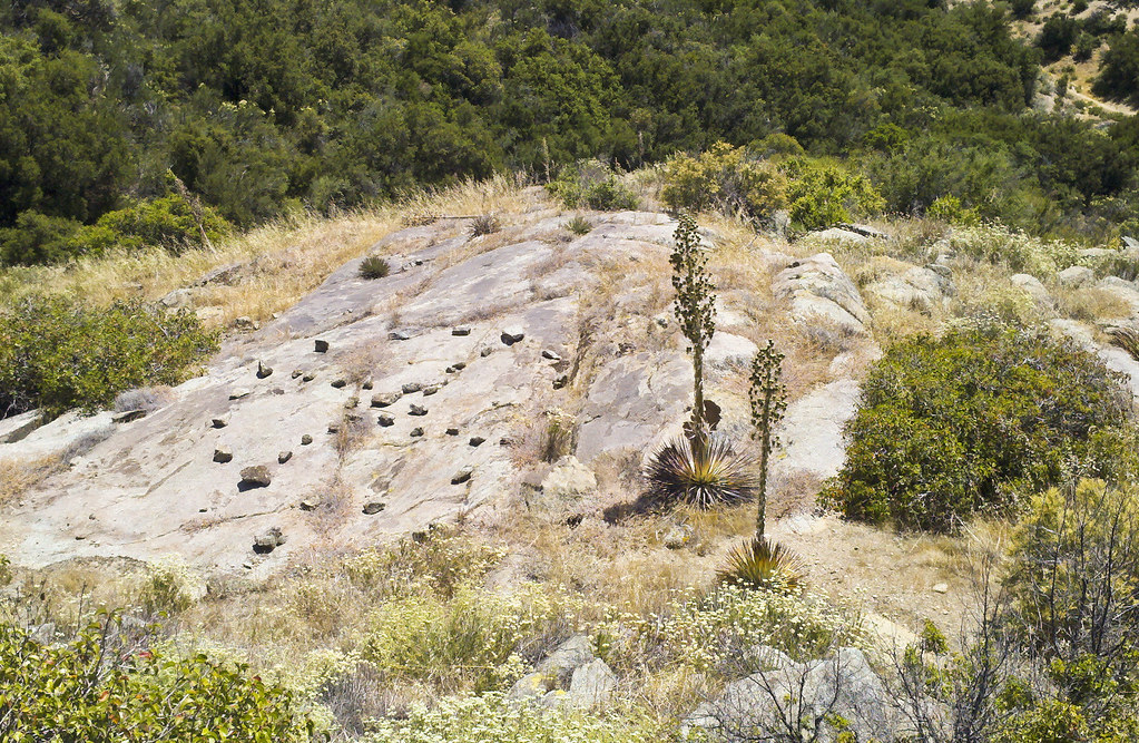
More morteros than I’ve seen on any one rock, near Indian Hill:

Recent campfire remains near Indian Hill and charcoal graffiti:

Close up of graffiti. Hunter shooting deer?

Some of the less-heralded pictos near Indian Hill:

Blue sun cave:

D stretched pictos:


Deep mortero near IH:

Rainbow (“rainblock”) near Dos Cabezas:

Morning fog in the valley and ever-present Pattern:

Mortero Palm Canyon:

View of fog and Pattern from Mortero Palm Canyon:

Crazy, twisted yucca stalk north of Jacumba Mtn:

Close-up:

On the way to Goat Canyon:

Goat Canyon Trestle:

Another mylar convert:

On the way to Dos Cabezas Spring:

edited by ziphius on 1/28/2013
edited by ziphius on 1/28/2013
--
http://www.coyotelearning.org
|
|
|
link
|
|
dsefcik Administrator Posts: 2634
1/28/2013
|
Nice trip....I was thinking of hiking the Mortero Palms route soon also. I think someone else also posted a photo of your rock glyph awhile back.
--
http://www.sefcik.com
http://www.darensefcik.com
http://www.carrizogorge.com
|
|
|
link
|
|
anutami Posts: 491
1/28/2013
|
Looks like you got some much needed rain. That ground glyph is strange. Hard to tell if it is indeed ancient. I ended up camping right by it when brett and I hiked to mortero palms. Did you d stretch the photo you labeled the less heralded pictos? You always seem to find the coolest type of plant life around.
Trip report
http://www.anzaborrego.net/anzaborrego/forum/topic232-mortero-palms.aspx
|
|
|
link
|
|
ziphius Posts: 911
1/28/2013
|
Nolan (anutami) wrote:
Looks like you got some much needed rain. That ground glyph is strange. Hard to tell if it is indeed ancient. I ended up camping right by it when brett and I hiked to mortero palms. Did you d stretch the photo you labeled the less heralded pictos? You always seem to find the coolest type of plant life around.
Trip report
http://www.anzaborrego.net/anzaborrego/forum/topic232-mortero-palms.aspx
Here is a stretched version of the 'less-heralded pictographs'. If you squint, maybe you make out a pink/red sun symbol toward to top center of the black picto?

The ground glyph had a bunch of pottery pieces in the center, which made me skeptical of it being very old. There were also very unique (non-granite) stones strewn throughout the structure. I should have checked with my compass to see if the 4 points roughly aligned with North-South-East-West. Also forgot to mention that there was flowing water (from a pipe) at Dos Cabezas Spring. The Mortero Palms to Goat Canyon Trestle overlook is very beautiful. The area above Mortero Palms Canyon and above Goat Canyon is relatively flat, with abundant choices for camping. But you've got to lug your pack up there through Mortero Palms Canyon, which is boulder-strewn for a good portion of the trip.
edited by ziphius on 1/28/2013
--
http://www.coyotelearning.org
|
|
|
link
|
|
surfponto Administrator Posts: 1369
1/28/2013
|
Looks like you had a great trip.
Love that route up and over Mortero Palms and then down into Goat Canyon.
Haven't done that route in a few years now.
Did you guys actually get rained on? Looks like a lot of water in the morteros.
Bob
--
https://www.anzaborrego.net/


|
|
|
link
|
|
ziphius Posts: 911
1/28/2013
|
surfponto wrote:
Looks like you had a great trip.
Love that route up and over Mortero Palms and then down into Goat Canyon.
Haven't done that route in a few years now.
Did you guys actually get rained on? Looks like a lot of water in the morteros.
Bob
Bob, we saw only sprinkles and arrived Saturday around 2pm. Judging by what I saw on the weather radar news images Friday, I think most of the rain fell that day. The old cement watering trough at the mouth of Mortero Palms Canyon had about 1/2 inch of water in it. There were numerous granite 'birdbaths' full of water almost everywhere we hiked. Dos Cabezas Rd. also had several large puddles. I joked that we didn't even need to bring water on our trip.
--
http://www.coyotelearning.org
|
|
|
link
|
|
surfponto Administrator Posts: 1369
1/28/2013
|
It is nice hiking out there after a rain.
Looks like you had the place to yourself 
Jim (ziphius) wrote:
surfponto wrote:
Looks like you had a great trip.
Love that route up and over Mortero Palms and then down into Goat Canyon.
Haven't done that route in a few years now.
Did you guys actually get rained on? Looks like a lot of water in the morteros.
Bob
Bob, we saw only sprinkles and arrived Saturday around 2pm. Judging by what I saw on the weather radar news images Friday, I think most of the rain fell that day. The old cement watering trough at the mouth of Mortero Palms Canyon had about 1/2 inch of water in it. There were numerous granite 'birdbaths' full of water almost everywhere we hiked. Dos Cabezas Rd. also had several large puddles. I joked that we didn't even need to bring water on our trip.
--
https://www.anzaborrego.net/
|
|
|
link
|
|
tommy750 Posts: 1086
1/28/2013
|
Jim (ziphius) wrote:
Did a one-night camp near Dos Cabezas. Hiked around the Indian Hill area on the first day. Set out for Mortero Palm Canyon the next morning, with Goat Canyon Trestle as our goal. Thick ground fog east of Octotillo in the morning, howling coyotes in every direction, mild temps. Fun trip.
On the way to Dos Cabezas Spring:
edited by ziphius on 1/28/2013
edited by ziphius on 1/28/2013
That's an interesting formation. Just read an article about a similar find somewhere in the Yuha Desert between Indian Hill and the Ancient Lake Cahuilla shoreline. The article is from Rock Art Papers Vol 13 and was first described in 1994. At that time, no similar circle had been found in the area closer than Isla Tiburon in Baja. Found another rock circle out day hiking the PCT above Kitchen Creek but mine looks pretty recent. Are these equivalent to the infamous crop circles or what? Tom
Rock Circle "outside of Ocotillo, CA"

Rock Wheel by tomteske, on Flickr
PCT Rock Circle. Trail is in the upper right.
Stone Circle PCT by tomteske, on Flickr
|
|
|
link
|