|
hikerdmb Posts: 423
9/15/2014
|
Got out to the desert for the first time since late spring. Headed out Friday about 5:00 PM. Didn't want to get out there too soon since it was well over 100 degrees that day. Made it to Little Blair Valley just as the sun set. It was only about 88 degrees when we got there and it was perfect weather for shorts and t-shirt. There was no wind and the stars and the Milky Way were quite spectacular until the moon came up around 9:00. There was lots of evidence on the road and in the small washes we passed that it had rained recently but everything was very dry. The ocotillo in the area were covered in new growth and a few had blooms. It never got the least bit chilly during the night so pretty much slept without any covers most of the night. Woke early on Saturday and took a quick climb up to the Shake Benchmark near our camp before the sun hit our camp.
Here is a pano from on top with Little Blair Valley on the left and Earthquake Valley on the right.

Here is looking down on the campsite from the Shake BM.

This shows some of the ocotillo near camp.

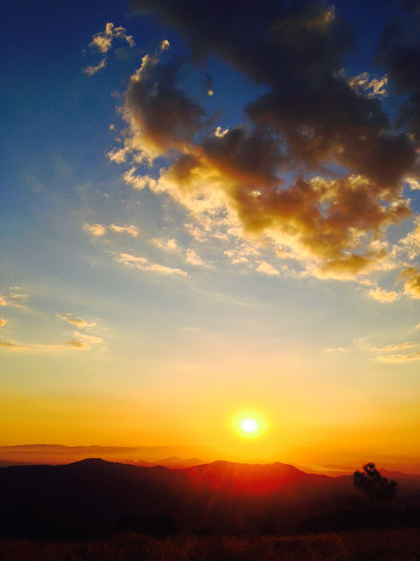
Sat in the shade for a while after I climbed down and then packed and headed to higher elevations. Drove back up S-2 and around the east and north side of Palomar Mountain. Then turned toward Anza and Thomas Mountain. Found a nice campsite at about 6,500' and enjoyed the cool temps of the mountains. Took a couple short walks around the area and enjoyed a fantastic sunset.
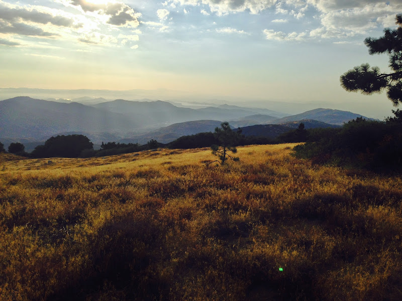
Here are some of the bigger trees on Thomas Mountain. They are really hurting from the lack of rain and snow the last few years. I couldn't believe the amount of dead wood on the forest floor. You can see some of the large branches which have fallen off these trees.

Here is the view looking north to Tahquitz Peak, San Jacinto Peak, and San Gorgonio Mountain.

This is the view to the west with Diamond Valley Reservoir in the center of the pic.
Finally here is a pic of sunset from about the same spot.
|
|
|
link
|
|
dsefcik Administrator Posts: 2634
9/15/2014
|
Thanks for the report David...I am thinking of heading out soon myself. Was the register still on Shake? I just got back from a week in the southern Sierras and am starting to see registers everywhere disappear, in fact a quick google search of summit registers missing will turn up some disappointing results. I noticed several years ago the register at Telescope Peak was gone and recently somebody here mentioned the Sombrero Peak register was missing. Several peaks I summited last week in the Sierras were also missing registers....very sad.
--
http://www.sefcik.com
http://www.darensefcik.com
http://www.carrizogorge.com
|
|
|
link
|
|
dsefcik Administrator Posts: 2634
9/15/2014
|
hikerdmb wrote:
Here is looking down on the campsite from the Shake BM.
Great thing about that photo is you can also see the Quake peak....Shake & Quake in Earthquake Valley
edited by dsefcik on 9/15/2014
--
http://www.sefcik.com
http://www.darensefcik.com
http://www.carrizogorge.com
|
|
|
link
|
|
hikerdmb Posts: 423
9/15/2014
|
I didn't look for the register on Shake so can't help with that. I have also heard stories of missing registers all over the Sierra. I think the story I read came to the conclusion that they were being taken because of some of the names in the old ones and because some people felt the need to "save" them before they were "taken." Would love to see some pics and hear about the Sierra. This is the first summer in 25+ years I did not make it up there.
|
|
|
link
|
|
dsefcik Administrator Posts: 2634
9/15/2014
|
hikerdmb wrote:
I didn't look for the register on Shake so can't help with that. I have also heard stories of missing registers all over the Sierra. I think the story I read came to the conclusion that they were being taken because of some of the names in the old ones and because some people felt the need to "save" them before they were "taken." Would love to see some pics and hear about the Sierra. This is the first summer in 25+ years I did not make it up there. I should have a couple sign in's on the Shake register...ditto on the reason why they are missing. I will have some photos soon, just haven't had time yet, got back Sat night and just trying to catch up. Mostly car camping for 5 days and then a 3 day backpack to Olancha Peak. The southern Kern river was DRY in Kennedy Meadows and in Monache Meadow it was barely 5 inches deep, it was just plain dry everywhere, unbelievable.
--
http://www.sefcik.com
http://www.darensefcik.com
http://www.carrizogorge.com
|
|
|
link
|
|
surfponto Administrator Posts: 1369
9/16/2014
|
Thomas Mtn looks like a great spot.Hopefully we get some rain soon to help out the trees.
Your sunset picture at the end is very nice.
Hoping for cooler weather so I can get back out there.
--
https://www.anzaborrego.net/


|
|
|
link
|
|
tommy750 Posts: 1086
9/19/2014
|
dsefcik wrote:
hikerdmb wrote:
Here is looking down on the campsite from the Shake BM.
Great thing about that photo is you can also see the Quake peak....Shake & Quake in Earthquake Valley
edited by dsefcik on 9/15/2014
BM Quake is on the ridge between Blair and Little Blair so it wouldn't be in this pic looking north into Earthquake Valley. This was a test right, Daren? 
|
|
|
link
|
|
tommy750 Posts: 1086
9/19/2014
|
Nice pics, hikerdmb. Never been to Thomas Mt. Looks like a great summer spot. Tom
|
|
|
link
|
|
dsefcik Administrator Posts: 2634
9/19/2014
|
Yeah...you got me...I was not looking closely enough....nice catch..
tommy750 wrote:
dsefcik wrote:
hikerdmb wrote:
Here is looking down on the campsite from the Shake BM.
Great thing about that photo is you can also see the Quake peak....Shake & Quake in Earthquake Valley
edited by dsefcik on 9/15/2014
BM Quake is on the ridge between Blair and Little Blair so it wouldn't be in this pic looking north into Earthquake Valley. This was a test right, Daren?
--
http://www.sefcik.com
http://www.darensefcik.com
http://www.carrizogorge.com
|
|
|
link
|
|
rockhopper Posts: 678
9/20/2014
|
Yes, Thomas mountain and valley are great areas to "hang out" and explore. Miles and miles of fire roads running from the south end all the way to Hemet lake. My Dad bought property up near the area back in the 60's. You could spent weeks roaming around up there. I always liked to go after a light snow fall ( man am I dreaming) for a water source. The road would dry out quickly but still find snow in the shade. There are remnants of buildings and home steads and mines all around Thomas peak. Many have been overgrown by brush.
One time in my previous non-politically correct life back in the 80's I was traversing the n-s ridge road on my motorbike when I found a fire brake running due west down from the top of the mountain down to Bautista canyon. Bulldozed probably from the 1950's. You know the ones that go straight up /down. Only a deer trail remained. Let's just say I dumped my CR480 cycle more than a few times to avoid going over the handle bars. Going back up was an other story. It was a 2000 ft hill climb. Like an endless Matterhorn hill climb from "On any Sunday" but hitting / busting thru scrub oak and Manzanita all the way up. It was one #^>^%&!!!! Well at least I widend the trail for the deer for a year or two.
|
|
|
link
|
|
dsefcik Administrator Posts: 2634
9/20/2014
|
I should have looked more closely, looks like Granite off to the left in the distance....thanks Tom for keeping me in line....
Digging thru my mazillion photos I found one from Shake looking towards Quake...Tom, can you please put it thru your verification test? David, sorry to go off topic from your post..


dsefcik wrote:
Yeah...you got me...I was not looking closely enough....nice catch..
tommy750 wrote:
dsefcik wrote:
hikerdmb wrote:
Here is looking down on the campsite from the Shake BM.
Great thing about that photo is you can also see the Quake peak....Shake & Quake in Earthquake Valley
edited by dsefcik on 9/15/2014
BM Quake is on the ridge between Blair and Little Blair so it wouldn't be in this pic looking north into Earthquake Valley. This was a test right, Daren?
--
http://www.sefcik.com
http://www.darensefcik.com
http://www.carrizogorge.com
|
|
|
link
|
|
tommy750 Posts: 1086
9/21/2014
|
rockhopper wrote:
Yes, Thomas mountain and valley are great areas to "hang out" and explore. Miles and miles of fire roads running from the south end all the way to Hemet lake. My Dad bought property up near the area back in the 60's. You could spent weeks roaming around up there. I always liked to go after a light snow fall ( man am I dreaming) for a water source. The road would dry out quickly but still find snow in the shade. There are remnants of buildings and home steads and mines all around Thomas peak. Many have been overgrown by brush.
One time in my previous non-politically correct life back in the 80's I was traversing the n-s ridge road on my motorbike when I found a fire brake running due west down from the top of the mountain down to Bautista canyon. Bulldozed probably from the 1950's. You know the ones that go straight up /down. Only a deer trail remained. Let's just say I dumped my CR480 cycle more than a few times to avoid going over the handle bars. Going back up was an other story. It was a 2000 ft hill climb. Like an endless Matterhorn hill climb from "On any Sunday" but hitting / busting thru scrub oak and Manzanita all the way up. It was one #^>^%&!!!! Well at least I widend the trail for the deer for a year or two.
That's a great story! Now, I'll definitely have to get out there. Thanks. Tom
|
|
|
link
|
|
tommy750 Posts: 1086
9/21/2014
|
dsefcik wrote:
I should have looked more closely, looks like Granite off to the left in the distance....thanks Tom for keeping me in line....
Digging thru my mazillion photos I found one from Shake looking towards Quake...Tom, can you please put it thru your verification test? David, sorry to go off topic from your post..
dsefcik wrote:
Yeah...you got me...I was not looking closely enough....nice catch..
tommy750 wrote:
dsefcik wrote:
hikerdmb wrote:
Here is looking down on the campsite from the Shake BM.
Great thing about that photo is you can also see the Quake peak....Shake & Quake in Earthquake Valley
edited by dsefcik on 9/15/2014
BM Quake is on the ridge between Blair and Little Blair so it wouldn't be in this pic looking north into Earthquake Valley. This was a test right, Daren?
Never been on Shake or Quake but it looks reasonable
|
|
|
link
|