4/16/2012
Topic:
Exploring The Island and Myer Valley
dsefcikAdministrator
|
tommy750 wrote:
Nice trip. Have started a few hikes from Old Hwy 80 and crossed under the tunnel toward Boulder Creek and Myers Creek but never checked out the island. Is that For Sale sign still up? Assumed it was the ranch to the west but never called the number. I hear there's a pile of cars that went off I-8 over by the ranch. Actually saw a PU fly off a few years ago. Didn't end well.
It was your picture of the shack that made us go..haha!! Yeah, the for sale sign is still there but is flipped around and facing east. I think the SPL project must have done it. |
4/16/2012
Topic:
Exploring The Island and Myer Valley
dsefcikAdministrator
|
Here are a few pics I took while out with Bob
Ocotillo's are blooming great right now

Fishhook Cactus

The Culvert

See any footprints??

Bob for size reference

We think this is a Hawk, I blame the SPL Project

Lupine in the wash

Old oil can that was smashed and nailed to a post at the shack

Some pics of the shack

Hey, nice view of the Sunrise Power Link tower in the background. Love those scenic back country views.

---

Up at the top of the saddle looking towards Myer Valley, it almost has sand dunes there is so much sand

Bob had to leave before I did so I had a few hours left and decided to go check out the Stage Station Historical Marker on the topo map, I have been wanting to go see that for some time now

This is about all I found though, I didn't see anything else and according to my GPS I was standing right on it.

There were some palms and a spring there though, that was pretty cool. These palms are right below the freeway, you can pull over and look down at them.

Here is the spring, it had some plumbing that was no longer hooked up. The water was flowing though and there were plenty of bees and birds everywhere

The Mighty Palms

Here is a panorama of Devils Canyon Bridge from down in Devils Canyon. Download the original (36mb)

<em>edited by dsefcik on 4/16/2012</em> |
4/16/2012
Topic:
coachwhip canyon and Palm Wash
dsefcikAdministrator
|
Very cool how you get truck into some of those areas. In the pic of the side rail I also noticed your shovel, looks like you had to do some digging! |
4/16/2012
Topic:
Exploring The Island and Myer Valley
dsefcikAdministrator
|
tommy750 wrote:
I stumbled on that cabin in 2005 heading out to Myers Valley. Stopped by last December and it looked about the same. If you have a copy of Chris Wray's "The Historic Backcountry," it has a blurb on this cabin and mentions another a little way down I-8, one I've never seen. It's listed as being at 32 40.39, -116 04.40. On Google Earth, looks like it's on a little rise near where a dirt road peels off the eastbound lanes.
Thanks for that info...maybe I missed something but those coordinates put a marker right at the shack we have posted pics of. I will look and see if I can find his book. |
4/17/2012
Topic:
Exploring The Island and Myer Valley
dsefcikAdministrator
|
mrkmc wrote:
They are not on the map. You can find a list of all the stations for each quad using the ngs website. (for some reason I cant link to the list generated or the data sheets) But follow the links on that site: Survey Marker Data Sheets> Data Sheets> USGS Quad> then enter In-Ko-Pah Gorge. Once you get to the list, you can select the station you want and tget the data sheet, which gives a writen description on how to locate the BM.
Very cool, they even have shapefiles..thanks! Caltopo is stepping it up a bit also, thanks for the tips! |
4/17/2012
Topic:
Exploring The Island and Myer Valley
dsefcikAdministrator
|
tommy750 wrote:
Oops! You're absolutely right. The other site is 32 41.42 -116 3.68
Great, I have that marked for my next trip out there. I have been wanting to go up that wash anyway (among 5 million others also). It seems that Chris Wray's book is a little hard to find. I wonder if the Butterfield Ranch store or the visitor center has it. The Butterfield store has some pretty funky old books on it's shelf by the register. |
4/17/2012
Topic:
Exploring The Island and Myer Valley
dsefcikAdministrator
|
surfponto wrote:
Here you go Daren
Seller is actually the author Chris Wray 
http://tierrablancabooks.com/retailers.htm
Looks like he has his own website, I may just email him and see if I can pick it up locally, or stop at the Desert Tower..haha...thanks Bob! |
4/17/2012
Topic:
Exploring The Island and Myer Valley
dsefcikAdministrator
|
tommy750 wrote:
I hear there's a pile of cars that went off I-8 over by the ranch. Actually saw a PU fly off a few years ago. Didn't end well.
Check the pictures on this website, scroll down about 3/4 of the way: http://nexthill.com/Photo's/Devils%20Canyon/index.htm |
4/18/2012
Topic:
Mason Valley Truck Trail /CRHT to abandoned mines
dsefcikAdministrator
|
Check out this map http://caltopo.com/map?id=7E42
Zoom in/out as needed and wait for the layers to load. I marked two routes into Chariot that I am familiar with. One starts at the Banner store and goes into the canyon to the mines. The other starts at the Fages monument and is much longer and steeper but more scenic. The Fages route is about 5-6 miles each way and the Banner route is about 2.5-3 miles each way. Personally I would say take the Banner route if you just want to see the mines and not spend all day hiking up/down fire roads drinking lots of water. From the Banner store you will see a cattle gate you can go thru and just keep following the fire road. Both routes have some moderate to steep climbs but the Fages route will be longer and more scenic with views of the desert.
I can't say I have checked out the mines, I was always in a race trying to cover a 100 miles in under the 30 hour time limit..but they always did look pretty cool.
Let us know how it goes.
Daren |
4/19/2012
Topic:
Near Piedras Grandes and Dos Cabezas
dsefcikAdministrator
|
OK, you almost had me going on the ten commandments photo...until I zoomed in on the original..nice try..8-)
How are you doing the lighting on the water tower, are you "painting" it with a flashlight? |
4/19/2012
Topic:
Mason Valley Truck Trail /CRHT to abandoned mines
dsefcikAdministrator
|
surfponto wrote:
Not to thread hijack but I have finally started using Caltopo. it is amazing! thanks for the tip Daren,
Thanks but the credit goes to mrkmc..he first posted about it. |
4/20/2012
Topic:
2012 Lyrid meteor shower This weekend
dsefcikAdministrator
|
This weekend will probably be a good time to check out the Lyrid meteor shower. A new moon, a weekend and warm temps all come together to make a great star watching weekend in the desert.
http://earthsky.org/tonight
<em>edited by dsefcik on 4/20/2012</em> |
4/22/2012
Topic:
Mason Valley Truck Trail /CRHT to abandoned mines
dsefcikAdministrator
|
I do remember a lot of private property signs as we went the chariot canyon. I would also like to see any reports of the mines..but be safe! |
4/23/2012
Topic:
The Turbines Are Coming
dsefcikAdministrator
|
The Turbines are coming! Fight the Ocotillo Wind Energy Project! This is for real!!

More info here
http://eastcountymagazine.org/taxonomy/term/3044
And here
http://eastcountymagazine.org/node/9438
<em>edited by dsefcik on 4/23/2012</em> |
4/23/2012
Topic:
Inner Pasture / Myer Valley
dsefcikAdministrator
|
A quick 24 hour trip to the desert in unusually high triple digit temperatures...pictures are worth a thousands words...good thing I have a camera....
Fishhook Cactus in Inner Pasture

Snakes are out

Up close

The Turbines are coming...fight the Ocotillo Wind Project!
Myer Valley Artifacts

Snakes are still out, this is a great reason why you should not put your hands in the rocks where you cannot first see what's there

Up close

Some blank rocks and DStretch

---

---

---

---

---

The meteor showers were not as vivid as the press made it out to be, I only saw a few meteors and photographed this picture of the Milky Way

Ants are a curious thing, these guys were hard at work at sunrise. Amazing to see thounsands of them toiling away making their home. Too bad projects like the Ocotillo Wind Project will kill them off

---

Total Mylar Balloons this trip - 4
http://www.sefcik.com/2012/04/inner-pasture-myer-valley.html
edited by dsefcik on 4/23/2012
<em>edited by dsefcik on 4/23/2012</em> |
4/24/2012
Topic:
Inner Pasture / Myer Valley
dsefcikAdministrator
|
tommy750 wrote:
How do you do "D Stretch?" Is it available as a photoshop plugin?
You can get DStretch from the website, you have to email the author of the software. http://www.dstretch.com/
I saw many snakes but only two proved photogenic. Several rattlesnakes and a black Coachwhip I believe, he was fast! The lizards were everywhere and it was so hot out in Moonlight Cyn and Inner Pasture even the rabbits were hiding in the shade. |
4/24/2012
Topic:
Inner Pasture / Myer Valley
dsefcikAdministrator
|
surfponto wrote:
Great pictures as always. How close were you to that rattler?
For both of those snakes I was within striking distance, maybe 4-5 feet. I used a 300mm lens. The one that was coiled up in a rock I actually had to use the flash and a tripod. He was pretty sleepy and stuck his tongue out at me a few times. It was like 99 degrees out and I was questioning why I was spending so much time trying to photograph this guy. The other one was slowly slithering along. I had originally planned to camp out in Inner Pasture but the heat and the fact that I saw rattlesnakes in 2 places I was scouting out to lay down my sleeping pad and bag sorta detoured me. I ended up hiking back to Agua Caliente from Inner Pasture at night. I think it was a good decision, the heat even at night was substantial, my truck outside temp gauge showed 89 degrees at 11pm. |
4/24/2012
Topic:
Rainbow Canyon
dsefcikAdministrator
|
TR, you kill me..I love your posts...
The barbed wire fence can actually be somewhat bypassed by walking a little SE towards the wash. The fence is stomped down to the ground and you can just walk over it. Your encounter with the cholla balls is typical for me, they get stuck on the shoe and then brushed up against your leg as walk. My usual method of getting them off is with 2 rocks, one on each side and a quick yank/pull but damn they hurt! I have followed the canyon up to Blair Valley, I personally like the whole canyon, it opens up to a wide sandy wash at the top, I saw some deer there last summer. There is another dry fall ahead, a double fall actually, you should go again when you feel up to it. There was a large hawk nest up in the canyon wall last summer when I went.
Nice pics, thanks for posting! |
4/24/2012
Topic:
Rainbow Canyon
dsefcikAdministrator
|
Oh yeah, was gonna add that the bugs are bad now and probably will be for a few months. I was getting pretty bent out of shape this last weekend over them, they were all flying in my eyes, nose, ears, mouth...I hate bugs but they love me. |
4/24/2012
Topic:
Rainbow Canyon
dsefcikAdministrator
|
Looks like someone did some rock piling to get up and over the dry fall.
TR wrote:
And of course the first of the dry falls. I was moving so slowly, takiing pictures, and had to take the time to pull all those cactus spines out with my Leatherman's pliers, I wasn't up for climbing the falls. Besides Schad says that it becomes less interesting above them. Or atleast that was my rationalization. I now have any excuse to go back again.
|
4/24/2012
Topic:
Inner Pasture / Myer Valley
dsefcikAdministrator
|
anutami wrote:
Daren, did you try to eat the fishhook cactus fruit? It is supposed to taste very good.
I have always wanted to try it
To be honest I did not know they were edible, I have had a couple others email me and also tell me that..now I know! Not sure I would have anyway, after seeing one big rattlesnake and almost stepping on another I sorta had my thoughts on just watching the ground until I got back to the truck.
<em>edited by dsefcik on 4/24/2012</em> |
4/24/2012
Topic:
The Turbines Are Coming
dsefcikAdministrator
|
You know it's like when you are shopping for something new (car, computer, phone, whatever) and all of a sudden you start noticing all the other people who have the same thing you are looking at purchasing and you never really noticed before until now that you are thinking of buying one...now that you are aware of the wind turbines being built you start noticing they are being built EVERYWHERE. If you cherish your back country invest a little time in trying to help fight some of these projects or at a minimum try and educate yourself a bit more about the technology and it's impact on our society and environment.
There are so many wind projects planned for the east county it is sickening, Ocotillo is just one of them.
Here are a few links to get started with
http://www.wind-watch.org/
http://www.basinandrangewatch.org/
http://protectourcommunities.org/ |
4/24/2012
Topic:
Inner Pasture / Myer Valley
dsefcikAdministrator
|
ziphius wrote:
Great photos Daren! I'm impressed that you hiked the Inner Pasture / Moonlight Canyon to Agua Caliente at night. Especially during a new moon. A few spots with tricky footing along the way. 4 mylar balloons is a lot, what's your personal 'best'? - Jim
Hah!..you are funny..I think maybe it was like 12 or something but that was because I found a "Love Bundle" of 9 balloons all tied together for a Valentine present.
The sun was setting in Inner Pasture and the snakes were coming out...I was way over around near the spring below Red Top. I had my huge backpack on and initially started the hike with 4 gallons of water, the lady at the Agua Caliente booth gave me a look when I said I was going out to IP.."OK, be sure take lots of water and watch out for rattlesnakes, they are out now" she said....."sodium/potassium tablets" I told myself. I drank 1 gallon of water just getting to the saddle before dropping down into IP. Anyway, starting back over the saddle in twilight and then descending into Moonlight Cyn in the dark with my lights I decided to take the east side loop back (ending up at the group camping area) instead of re-tracing my steps back on the west side. There was a very warm breeze all night but it was way better than the sun. As I got to the left/right choice around the low peak of the trail I went right....and then a short distance later I came to like a 50' or higher dry, steep fall. Crap....my headlamp made out a faint trail up the side and then down the other side. When I got to the bottom of the bypass I saw a sign that that said something like "DO NOT ENTER!!" I continued down the trail and just before the water and tall tree area I heard a loud buzz/humm..in the dark. I stopped and turned my ears towards the sound...a bee hive up in the rocks...nice..I kept moving. Soon the the lights of vehicles on the S2 were visible and I could hear the sounds of happy Agua Caliente campers. It was about 9:30pm now and someone was giving a star show lesson at the outdoor area near the booth....pretty much beat to crap I continued down the pavement with my pack on hoping the store would be open so I could buy some cold beer....but they were closed. That's OK, I needed the extra walk anyway. Now 10:30pm or so I loaded my crap into my truck and drove over to the Carrizo Badlands overlook. The warm breeze still blowing was great, the stars were out and Venus was as bright as the sun. I washed off, ate some food and listened to coyotes howling before I fell asleep. Around midnight I woke up and there was a car pulling up next to me...a woman just trying to find a place to pull over and sleep for the night.....never know what you will see in the desert.
The next day was Myer Valley...the pictures I posted show a small view of that day...I might elaborate more on that in another post..suffice to say the undocumented traffic is alive and well, the Border Patrol had some action that Sunday afternnon.
Thanks for reading my ramblings...
Daren |
4/26/2012
Topic:
Inner Pasture / Myer Valley
dsefcikAdministrator
|
The sandy wash coming in from mile marker 41 is much, much easier. It is longer distance wise but so much easier than Moonlight Cyn. If you haven't gone that way yet you might want to check it out. Also the saddle from the North Fork into Canebrake is another way. Interesting note in one of Schads book is that the IV saddle at one point was being considered by the BLM as a planned hiking/equestrian route from Pepperwood down thru Canebrake...guess that never happened. |
4/30/2012
Topic:
Devil's Canyon
dsefcikAdministrator
|
Looks like there were a lot of footprints in Devils Canyon. |
4/30/2012
Topic:
Oriflamme Canyon
dsefcikAdministrator
|
I really liked the photos but I did struggle with flickr as it was not loading for very well.
What is the ruins photo? I have not seen that before.
Looks like you also made it over to the Blair Valley Pictographs. Lizards love that area and I love the view from Smugglers Cyn!
I gotta ask, how were the bugs?
kylekai wrote:
I was there last weekend. Took some pictures:
http://flic.kr/s/aHsjz7xNLU
One nice thing about using Flickr is the associated map with each picture. The geotag is usually correct, and it helps in pinpointing the location of the picture.
-Bill |
5/2/2012
Topic:
Whale Peak - Backpacking
dsefcikAdministrator
|
Did you guys get any photos of the space station? I saw this one online. If you get tired of the duck trail I know another way up that I can show you, it doesn't have any ducks...
Nice TR, glad nobody was around, looks like it was a great trip. |
5/2/2012
Topic:
Missing hiker Anza Borrego Mud Caves
dsefcikAdministrator
|
I am not seeing any status updates for this, has he been found or what? Anybody know?
danielle179 wrote:
Thank you for posting this!
facebook.com/FindGuillermoPinoJr |
5/5/2012
Topic:
Pattern Sucks
dsefcikAdministrator
|
While out near Ocotillo for some non hiking business I saw the Trading Post put up a new sign. There are already Fiber line pedestals installed along the S2 to accommodate the infrastructure for the turbines.

Carrion is an easy source of food for the wildlife. A Turkey Vulture and a crow took turns on rabbit roadkill while a hawk stayed elusive to my camera.

---

I am not sure why the Old Highway Cafe sign caught my eye this time and never before, really neat sign

-- |
5/5/2012
Topic:
Body Believed To Be Missing Hiker Found
dsefcikAdministrator
|
Thanks Bob, sad but at least they have found him. |
5/6/2012
Topic:
Body Believed To Be Missing Hiker Found
dsefcikAdministrator
|
Interesting how every media outlet has a different story, The Union Tribune Article says the battery died on the camera and the family was not able to show the photos to the sheriff that arrived on scene. Hopefully the story will unfold today. Very sad. |
5/7/2012
Topic:
Coyote Mountains
dsefcikAdministrator
|
Great post, I camped out there with my son last October, it was a quiet, peaceful place to camp. I just pick up the ballons and pack them out, big horn and other wildlife eat them and die. I picked up (4) last week in Indian Valley.
http://cawsf.org/Floating_Menace.pdf
Quoted from this document
"Researchers agree that ingested balloons and balloon frag-
ments can potentially harm any species of wildlife. But bighorn
sheep may be particularly at risk because of the way they eat
and digest food. Bighorn sheep have the same digestive system
as cows, goats, domestic sheep and other cud-chewing animals.
They eat only plants, and have a specialized four-chambered
stomach which extracts nutrients from indigestible plant materials.
-------
a DFG associate wildlife biologist removed enough balloons from one of the chambers of a bighorn's stomach to fill a plastic bag. Next page: An investigation of
this deceased bighorn sheep showed the animal had swallowed plastic
balloon strings while their other ends remained entangled in the sheep's
mandible and teeth." |
5/7/2012
Topic:
Coyote Mountains
dsefcikAdministrator
|
tommy750 wrote:
Wow. Just thought they were yet another piece of trash left by the careless. Will check out the link. Tom
I learned about this at the annual BHS Count orientation. What is even more depressing is the encroachment of humans across the deserts and how their modern non native lifestyles are killing them off also. Some examples are all of the pumped in water that gets fertilizer and other chemicals in it and all of the grass, flowers, plants, etc they try and eat and it kills them. Anyway...enough from me about this...
Here are some petroglyphs in Death Valley some of you may have seen them, I stumbled on them by total accident. Sorry to hijack the thread, maybe somebody will enjoy seeing these.

---
 |
5/8/2012
Topic:
Inner Pasture / Myer Valley
dsefcikAdministrator
|
This is the best I have. Not sure I see 1865 but there is something there as well as above the larger figure on the right. These dstretched photos show clearly that they have been painted over, or "touched up" if you will.
 |
5/8/2012
Topic:
Coyote Mountains
dsefcikAdministrator
|
Ditto on the Badlands photo, very cool...is that is Diablo BM of in the distance?? That whole area always looks very cool at sundown. |
5/11/2012
Topic:
Best Mylar Ballon Trip
dsefcikAdministrator
|
What is your best mylar ballon take for a trip?
Here are just a few of mine
Canebrake Wash (as Tommy750 found, one of these had a note..an "I love you so much" type note)

Blair Valley (9 balloons in this bundle)

Indian Valley

<em>edited by dsefcik on 5/11/2012</em> |
5/11/2012
Topic:
Body recovered from Anza Borrego Mud Caves
dsefcikAdministrator
|
What I read today suggested a group looking for him created some kind of cave in that allowed them to see his body. I know I have been in Hidden Cave many times before, alone on triple digit days...food for thought. The family has shown amazing strength thru all of this. |
5/13/2012
Topic:
Best Mylar Ballon Trip
dsefcikAdministrator
|
tommy750 wrote:
My average number of baloons picked up per hike was zero---till I joined this forum. Now I scoop up every one I see thanks to you. Tom
GREAT!!!
There are some though that are so crumbly and dried up in thick catclaw that not even the best of us can recover. I have tried to get a few only to have them crumble into dust and float away.
BEWARE of putting your hands into a bush to extract a balloon, ALWAYS make sure there are no snakes or other critters in there first!!
Thanks Tom!! |
5/13/2012
Topic:
EL VALLECITO AND LA RUMOROSA STYLE
dsefcikAdministrator
|
Nice...very nice!
DStretch brings a whole new dimension to rock art doesn't it??
I have seen a video of the solstice sun shining on the eyes of the diablito.
I will be looking a bit more closely at all of the photos you posted, I have always wanted to get down there.
I have found so many pictos just taking pictures of (blank to me looking at them) rock surfaces and then running them thru DStretch later that it is amazing.
Great post Tom, thanks for sharing that!
Daren |
5/14/2012
Topic:
Villager Peak
dsefcikAdministrator
|
Welcome to the forums rockhopper!
Those are some great pictures, I really like the Santa Rosa and false Villager Peak one. Did you see anybody else out on the trail, any wildlife?? What were some of the most recent entries in the register? What was your total time up/down? |
5/14/2012
Topic:
3D Panoramic Virtual Tours
dsefcikAdministrator
|
Here is a link to a couple of 3D panoramas I worked on tonight, let me know how they work. I like the full screen mode myself, zoomed in and panning top-to-bottom. If I had a webserver to host files on I could make an HTML5 version for mobile devices like the iPad/iPhone and the Android...oh wait, Android already does Flash....my bad...
https://sites.google.com/a/sefcik.com/virtual-tours/home
Daren |
5/15/2012
Topic:
EL VALLECITO AND LA RUMOROSA STYLE
dsefcikAdministrator
|
tommy750 wrote:
Decided to head down to La Rumorosa (El Vallecito) site and see what he was talking about. The girlfriend and I made our way south through Mexicali and headed west on Hwy 2. If you enjoy the I-8 grade entering/leaving the Imperial Valley, La Rumorosa grade is that times 5. Here's a link to a 2 min video from yesterday while driving down the grade:
It has been a few years since I have driven in Mexico but I thought it was interesting all of the rest areas were on the **left** side of the highway. |
5/15/2012
Topic:
Best Mylar Ballon Trip
dsefcikAdministrator
|
OK, at first I was dying from laughter reading your ideas, then I realized you had some great ideas...self destruct balloons?? Perfect...humm..except what if they were released near wildlife to begin with? Good start though. How about making the balloons out of eco friendly or digestible materials to begin with? Ziphius, I think you are on to something....
ziphius wrote:
Before this thread started, I had been talking with my girlfriend about the balloon problem. We had both read the 'Floating Menace' link that Daren posted and thought of ways to reduce the number of balloons released into the wild. Besides outlawing helium, our main crazy idea was a form of eco-terrorism, involving popping the balloons in-store before they are sold. It would take a subtle method, such as a straight pin or a micro- blow-dart straw. Eventually, you would get caught. So, we're working on other ideas, such as education campaigns. My girlfriend thought of a "balloon deposit", where you return the balloon to the store to get your money back. But the deposit would have to be big enough (say $5) to motivate people to return them. If folks would just stop losing them to the sky...... any technology out there that could be inside the balloon so that when it reached a certain height, say 50 ft., it would "pop" on its own? That would at least keep a majority of the balloons in urban areas.
On an unrelated note, we were picking up trash at Coronado Beach last weekend and I came up with the idea of training corvids (crows, jays, ravens) to fly around and pick up trash and return items to a reward station for food pellets. They are very smart birds with great eyesight. |
5/15/2012
Topic:
3D Panoramic Virtual Tours
dsefcikAdministrator
|
herofix wrote:
Agreed, those are awesome. How do you get Google to host content that large?
Since I don't have a web server to host regular html files I made the panorama all in one flash swf file, they are about 10-15mb each and I need to figure out how to speed up the initial load time. In google sites you can add "attachments" and then I link from there. I used a Flash Gadget to embed it.
This is my first stab at panorama 360 tours, I have some ideas how to make them better...thanks for your feedback! |
5/15/2012
Topic:
3D Panoramic Virtual Tours
dsefcikAdministrator
|
hikerdmb wrote:
Nice Daren. I did not see your backpack by the truck though. Did you use a tripod for those pics?
David
No tripod, all hand held.
My backpack is in the bushes near me taking the pictures. I NEVER saw it in the photos until I did the panorama.....
Thanks for looking at it and the feedback! |
5/16/2012
Topic:
Hike through Banner mine district
dsefcikAdministrator
|
Great report....
Yeah, the hike in is an old fire road (I think I mentioned that in the other post?) but it is way nicer then from the other route in from the highway near Lucky 5, that route is way steeper and longer. I bet if you went on a weekday the Jeep traffic would be less, I have been out there when everybody in San Diego who has a Jeep was there..ugghh..
Nice photos, and let me get this straight you brought binoculars and a camera but no candles or lanterns to explore mine shafts???
What was all the garbage in the mine shaft photos? |
5/20/2012
Topic:
Hike through Banner mine district
dsefcikAdministrator
|
Nice story rockhopper...for anyone who has never explored mines in Death Valley (Panamint, etc) you can only imagine what deep, dark death traps they are. The folks that lived their lives out there doing that were some of the toughest folks that ever lived. My son tried to talk me into descending down into some deep shafts out at the Minnietta Mine but I assured him that it was not safe! |
5/23/2012
Topic:
Misc Photos from last week
dsefcikAdministrator
|
Was out on some volunteer efforts last week and took a few photos while out in the field. No spectacular mountain summits or multi day backpack trips, just some photos.
Snakes are still out. I saw this Rosy Boa as I was walking around my truck, he must have slipped under for some shade, it was 104 that day. I know, nowhere near as heroic of a photo as the one Bob posted with him holding the snake.

This Red Racer was slithering around my work area all day. He eventually ate a pack rat that was nearby.

I found a dead Desert Centipede, these guys look really nasty. He was about 3" long.

Check out this close up of his "claws"

And lastly a sunrise photo over the Fish Creek Mountains, beautiful morning

Also stopped to see the Ocotillo Wind Energy project destruction beginning. I made a 3D panorama of it, click here to view.
That's it, hope you like the photos. |
5/23/2012
Topic:
Big cool-down predicted for the weekend
dsefcikAdministrator
|
Let us know how it goes, bring back some balloons!
I may head out to Myer Valley but maybe not..... |
5/23/2012
Topic:
Misc Photos from last week
dsefcikAdministrator
|
tommy750 wrote:
Been trying to get the girlfriend out camping in the desert more and therefore will NEVER be showing her this post!
Maybe just show her the sunrise photo...or tell her the snakes eat the centipedes..... |
5/23/2012
Topic:
Misc Photos from last week
dsefcikAdministrator
|
surfponto wrote:
Kind of why I like the rooftop tent.
I would have been down with that...but all I had was a big rock so I slept on that instead for two nights.... |
5/27/2012
Topic:
Inner Pasture on a cool 5/26. 5 balloon trip!
dsefcikAdministrator
|
THANK YOU for identifying the Western Tanager, I saw several of these gorgeous birds in Indian Valley last week but did not know what they were. They are beautiful birds!
The small shelter you found with the morteros had some black painted graffitti low down on the underside of the shelter last time I was there. The smaller shelter just to the west was FULL of clothing and food. That route is obviously GPS'd by the undocumented folks and I have found shelter after shelter from there up to Pepperwood filled with their crap. I have asked several times within the park circle if there was a way to get in there with my truck and clean it all up but nobody seems interested. The border patrol doesn't care, in fact I was told that the Murrietta branch patrols that area, not our SD branch! You have to remember the route from Pepperwood down thru the wash at marker 41 is a known route for the undocumented and I have twice now seen people there.
Nice collection of balloons, 5 less to worry about.
As far as any spring goes, I have found water and bees on the far south end of that jeep road you followed (probably off/on). There is a lot to see out there and I love the Inner Pasture/Canebrake area, one of a few really remote areas we are still lucky to have. We should hook up next time you wanna go out there.
Nice TR!
Daren |
5/28/2012
Topic:
Inner Pasture on a cool 5/26. 5 balloon trip!
dsefcikAdministrator
|
surfponto wrote:
Like Daren says that is a fantastic remote area to explore. Our Inner Pasture Trip was with Daren , and I would like to do it again at some point.
That was a good trip we did, I remember it now looking at your pictures.
I still want to do a one way from Indian Valley up into Canebrake and then back out to marker 41. Needs two vehicles though. If anybody is interested doing that trip let me know.
Daren |
5/29/2012
Topic:
Memorial Day Weekend: Sombrero Peak
dsefcikAdministrator
|
Nice post, glad you AND the GF got out to the desert.
The IVDM is actually one reason I was out there last week, I was helping catalog and inventory some of their collections. Yes, Jennica and the others are very excited to get the museum open. I encourage everyone to stop by and check it out, they have some neat stuff there. They have a Facebook page also for more info http://www.facebook.com/IVDMuseum
You obviously also saw the destruction of Ocotillo beginning, the wind generators will be up in no time if we are not able to stop them. More info here http://www.basinandrangewatch.org/OcotilloWind.html
I got stung once by africanized (I believe) bees in Indian Valley once, wasn't a good start to the day, Bob can tell you about that one. Good call, stay away from the bees out there, they are mean and will chase you.
From your Flickr set it looks like you got out to Blythe and saw the intaglios and quite a few petroglyphs, I liked those photos, I want to get out there one of these days.
No balloons this trip?? |
5/29/2012
Topic:
Inner Pasture on a cool 5/26. 5 balloon trip!
dsefcikAdministrator
|
ziphius wrote:
Hey Daren, you mentioned hiking to a spring in Inner Pasture on your last trip, is it the one shown on the topo at 32.904 and 116.342? If so, was there water?
That is the spring I was heading for when I went out from Moonlight canyon but turned around more near the "island" out there so I did not get a chance to see if there was any water flowing.
Where I have seen water on two separate visits (with lots of bees) is on the other side in Canebrake 32.865, 116.304. There is no marked spring on the topo but there is water and an old cement trough.

---
 |
5/29/2012
Topic:
Memorial Day Weekend: Palo Verde/Blythe Intaglios
dsefcikAdministrator
|
Nice, I already saw them in your Flickr stream..thanks for sharing. I gotta get out there soon and see them, almost went over Christmas but didn't make it. |
5/30/2012
Topic:
Memorial Day Weekend: Palo Verde/Blythe Intaglios
dsefcikAdministrator
|
The BLM website mentions (6) glyphs total at (3) different sites, do they all still exist and did you visit them? You only show photos of (2) glyphs. |
5/30/2012
Topic:
Memorial Day Weekend: Palo Verde/Blythe Intaglios
dsefcikAdministrator
|
tommy750 wrote:
Search "Blythe Intaglios" on Google Earth and you can see them all from space. Tom
wow...almost like actually going there...except you can see them better! Thanks for that info, very cool... |
5/31/2012
Topic:
Memorial Day Weekend: Sombrero Peak
dsefcikAdministrator
|
tommy750 wrote:
Couldn't tell you more about the ollas. Maybe Daren could since he's doing some curation work at the museum. Tom
Afraid I don't, I worked mostly with lithics the day I volunteered. While many of the museums locally have great examples of ollas, I would guess there are still a few hidden ones out there still buried away. |
5/31/2012
Topic:
Inner Pasture on a cool 5/26. 5 balloon trip!
dsefcikAdministrator
|
tommy750 wrote:
How ironic the little story on the phone card you found in the middle of the desert is about the cliff divers of "La Quebrada" in Acapulco. Nice post. Would love to get out there some day.
Aren't the Latadel cards usually sold or marketed to tourists to make calls back to he US or other countries outside Mexico?
tommy750 wrote:
Happened to have met one of the current owners of the Crawford Ranch earlier this year. When I asked about pictographs etc. in Inner Pasture, the owner hesitated a while and then suggested I try Blair Valley! Tom
You can find the pictos, just need to go look for them....how about asking your new friend if we can drive out in my truck thru their property to cleanup all the illegal clothing and trash??? |
6/12/2012
Topic:
Best Mylar Ballon Trip
dsefcikAdministrator
|
From that NBC article:
When mylar balloons got caught in overhead power lines, the lines were overloaded, broke and fell on cars parked along Lincoln Avenue according to a utility spokesperson.
Mylar balloons "overloaded" a power line and caused it to break and fall??
Nice one tommy750 |
6/18/2012
Topic:
Old Fire at Live Oak Springs
dsefcikAdministrator
|
Driving back from ABDSP I took a few photos of the Old Fire. It looked really, really bad. I hope they are able to contain it.
Here is what the fire looked like from the S2 at Canyon Sin Nombre

Driving towards the casino

Near the Casino

And a panorama (click to enlarge)

Here is a movie clip (click to view)

<em>edited by dsefcik on 6/18/2012</em> |
6/18/2012
Topic:
Desert View Tower and Table Mt
dsefcikAdministrator
|
Did you go see the Hidden Spring at the top of the hill near the tower?
Apparently the owner didn't appreciate alien paparazzo and marched out yelling at me
That's coyotejeff, he took me on a grand tour in the space craft last time I stopped by, we went by the worm hole and everything. Weird you got barked at.
looks like someone is up there with a big antenna on the back of their truck.
That is Border Patrol. They have had the vehicle up there for like a year or so.
I got a few pictures yesterday also of the fire, it looked pretty bad, I hope they are able to contain it. I will post in a new topic. |
6/18/2012
Topic:
Old Fire at Live Oak Springs
dsefcikAdministrator
|
tommy750 wrote:
So what were you up to out in Canyon Sin Nombre on such a lovely warm day?
Was out for BHS Count orientation but hit up Myer Valley on the way out and then Sat/Sun drove my big ass truck out to the end of Rockhouse Cyn rd. Will try to post something tonight or tomorrow, I have been busy..sorry... |
6/18/2012
Topic:
Desert View Tower and Table Mt
dsefcikAdministrator
|
ziphius wrote:
links: http://www.ranchocostanada.itgo.com/
Damn, even his web hosting provider is cheap $0 per month! |
6/18/2012
Topic:
Desert View Tower and Table Mt
dsefcikAdministrator
|
dsefcik wrote:
Did you go see the Hidden Spring at the top of the hill near the tower?
tommy750 wrote:
Didn't get around to climbing up to the spring. Have climbed up to the top of the ridge and headed north to a nice Valley overlook but was a little cooler then.
Took me awhile to find it but if you want to see what the spring looks like and where to find it click here
I didn't want to spoil it for anyone who wants to find it on their own so if you just want to see it you can click my link above. The owner is real proud of the spring and when I was there a mother and her daughter toughed it out all the way to the top and they were very surprised when they finally found it!
PS, if you decide to look at the photo, look closely, there are (2) different springs, one is actually somewhat hidden and harder to spot.
Daren |
6/18/2012
Topic:
Desert View Tower and Table Mt
dsefcikAdministrator
|
If you continue down the dirt road past the Table Mtn area you can see a couple of microwave/radio towers and then further on several mines and an "ornate stone cabin" or something similar Lindsay describes it as. The area is rich with Indian history and you can find morteros and pottery in the area. There are as many as 5-6 wildlife guzzlers out there also, I can't remember exactly how many I have seen..maybe even seven or so. Really, really neat area.
<em>edited by dsefcik on 6/18/2012</em> |
6/19/2012
Topic:
Lower Willows Trail
dsefcikAdministrator
|
Another great TR by TR..thanks...
That lizard is a Desert Iguana and they move fast!
Nice shot of the Dragon Fly, I wonder if the golf ball drifted down from another area.
This year has been a very dry year and the rangers have also commented on how dry it is, it will be very tough on the BHS.
I should also just remind everyone that Coyote Canyon is closed from June 1'st to Sept 30th each year to all users. It allows the BHS to get water during a time of year that is critical to their survival.
I did see a BHS Ram last Sat in Rockhouse Cyn and heard reports of sightings in other areas of the park also.
TR, thanks for packing out any garbage you found, much appreciated!
Daren |
6/20/2012
Topic:
Lower Willows Trail
dsefcikAdministrator
|
ziphius wrote:
Your golf ball might start a new forum theme along the lines of mylar balloons... what was your best golf ball day in ABDSP?
 OMG, I hope not!! Aren't golf courses kinda passé by now anyway?? OMG, I hope not!! Aren't golf courses kinda passé by now anyway?? |
6/20/2012
Topic:
Lower Willows Trail
dsefcikAdministrator
|
TR wrote:
Daren;
Do these Iguana change color? I saw one before on pavement, and it was much darker.
I have never seem very dark but according to the Iguana Survival Guide they do change colors somewhat.
http://iguanasurvivalguide.com/blog/iguana-care/know-more-about-desert-iguana/
I got a picture of this guy in his defensive posture, I read that iguanas will open their mouth when challenged to increase their lateral size for defense purposes
 |
6/20/2012
Topic:
Myer Valley / Rockhouse Cyn
dsefcikAdministrator
|
No big tortuous hike or backpacking trip, not even a crazy whiskey induced campfire story....just some side trip photos from driving out to the annual BHS count orientation meeting. Drove out last Friday after work and pulled off the highway to try and find the "second" old shack near Myer Valley. Very quickly I needed to switch into 4WD Low to pass thru the dry creek and up a few sketchy sections before seeing the BLM sign indicating no vehicles were allowed beyond that point. Being the do-gooder that I am I decided to turn around and not break any laws, I really didn't have to time to go hiking for hours, it was already around 5pm....but I had to pee first before leaving. As I got out and started my business I looked down and saw some pottery sherds..OK, time to look around.
I grabbed my camera and a 32oz bottle of water and also left a few bottles of water outside my truck for anyone who might just be "passing by" and started walking. It did not take more than 15 minutes before Border Patrol agents were walking towards me. We chatted a bit and they indicated that the area was very active, typically apprehending several people each day and night. I started poking around and found some interesting items but nothing earth shattering so sorry if this post bores you....
Some large pottery sherds

This old glass bottle had some vintage purple tint to it, hard to see in the photo

Awww..the remains of recent weary travelers, "fresh ones" I think the Border Patrol called them...

The no refrigeration required frijoles intrigued me, I want to try and find some for my next extended trip. The pop top tuna cans are standard issue these days though.

I am not sure what to make of this page in the travelers log, a list of some sort.

We got David's cellular and home phone number on this page though (numbers partially blurred on purpose)

Here we got the password to $100 somewhere

There were some cultural items of interest also, here is a nice milling area

And a nice milling stone

For you Encyclopedia Brown types out there, the pottery sherd photo has some clues about my mode of travel, maybe not to Myer Valley but definitely that day....see if you can find them.
The sun was going down and it was time to leave, I would find the second shack another day. I needed to get to Borrego Springs and camp out for an early Sat morning meeting. I camped out near the Pegleg Smith Monument.
Having fun with my new 7mm fisheye lens

----

After the BHS count meeting I drove out to the end of Rockhouse Canyon road in my big ass crew cab truck. It was slow going but after several 2 point turns, 4WD Low and 2 hours I got to the end. The truck overhead dash showed an outside temp of 100 on Sat and 108 on Sunday although I think the official temps were higher.
On the way in I saw a Bighorn Ram, dumbass me though left the fisheye lens on in manual focus and got nothing but blurry pictures...

Here is a 100% crop of the photo

I am hopeful David or someone can point out some stars in this photo, I know the Milky Way is there

Didn't have a chance to do much more than hike to the spring and look around, I want to go hike into Rockhouse Canyon and explore a bit. Here is a view of Rockhouse Canyon from the ridge line above Hidden Springs
My large truck made it to the end of the trail but not without scratches and damage. Several differential and exhaust pipe scrapes and all of the tires cut up. There were several narrow areas for my truck that needed boulder climbing.

Total Mylar Balloons this trip - 2

Thanks Elmo... |
6/21/2012
Topic:
Myer Valley / Rockhouse Cyn
dsefcikAdministrator
|
tommy750 wrote:
No ruins at all of the shack?
I didn't get far enough to really look, there are No Vehicles Allowed BLM Wilderness signs almost immediately after you get going. Of course that doesn't stop the Border Patrol. I asked the BP agents about it and they said they have seen the one down by the culvert but not anything going up into Myer Valley. I am going to hike in when I get a chance. |
6/21/2012
Topic:
Myer Valley / Rockhouse Cyn
dsefcikAdministrator
|
tommy750 wrote:
That's exactly how my alleged "Rugged Trails" tires looked about 50 yards after I left the pavement for the first time. Blew one out after hitting a pebble driving up Painted Gorge for a night hike up Carrizo Mt and spent an hour cursing Toyota for putting them on their TRD equipped Tundras while I wrestled with the spare in the dirt. Happy happy with the BFG A/Ts all around. Tom
Yeah, I have sliced two tires so far, both in Death Valley on rocks. Expensive buggers. |
6/21/2012
Topic:
Myer Valley / Rockhouse Cyn
dsefcikAdministrator
|
I did not get that far, the BLM Wilderness signs are right after that first U bend in the road. While I cannot advocate for driving past those signs I doubt anybody is out there checking right now. I will just park and hike in when I have time. The BP said they have not seen any shacks there but they know about the other one.
tommy750 wrote:
dsefcik wrote:
tommy750 wrote:
No ruins at all of the shack?
I didn't get far enough to really look, there are No Vehicles Allowed BLM Wilderness signs almost immediately after you get going. Of course that doesn't stop the Border Patrol. I asked the BP agents about it and they said they have seen the one down by the culvert but not anything going up into Myer Valley. I am going to hike in when I get a chance.
If we're talking about the second miner's shack down the eastbound lanes from the one near bolder creek, it maps on Google to the little plateau just yards up the dirt road from I-8. Just found the coordinates in an earlier post re your Island trip: 32 41.42 -116 3.68 Tom
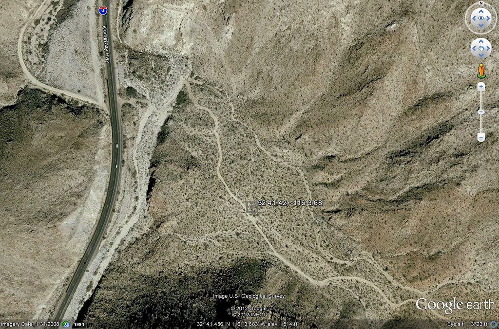
Miner's Shack by tomteske, on Flickr |
6/22/2012
Topic:
Myer Valley / Rockhouse Cyn
dsefcikAdministrator
|
hikerdmb wrote:
Good job getting to the end of Rockhouse in your truck. That is tough and requires some patience and skill. I am assuming you did it solo with no spotter either. By comparison when I did my Rockhouse trip this spring it took me about an hour in my jeep to get to the end of the road. I did not see anything like your truck back in there. The other full size rigs I saw were parked at the split with Butler Canyon. A long time ago I took my old Dodge up that road but it did not have 4 doors or an 8' bed.
David
Thanks David, I did drive out with another BHS counter from the meeting, he had a 4Runner and I had to spot him
To be fair though he had less ground clearance. I did not need any spotting, that damn truck in 4WD Low is pretty amazing to me, it just crawls over anything it has clearance to get over. I did get a few differential and tail pipe scrapes though and there were some narrow spots I needed to just put the wheels up and over on.
I thought Scorpius was in the stars photo in the lower right but what do I know. The Milky Way was straight overhead around 1 or 2am when I woke to take a look. |
6/22/2012
Topic:
Scotchman's Peak, Northern Idaho
dsefcikAdministrator
|
I was getting cold just looking at your photos....I think the deer saw *you*....Nice flower tour.
A black bear was reported in Mason Valley in May 2000
http://www.backcountry.net/arch/pct/0005/msg00265.html |
6/23/2012
Topic:
Myer Valley / Rockhouse Cyn
dsefcikAdministrator
|
I was just looking more closely at the map and I take back my comment. I parked at the small clearing just below the marker on the map. I did not go look anywhere on that side of the road though....humm, next trip out.
dsefcik wrote:
I did not get that far, the BLM Wilderness signs are right after that first U bend in the road. While I cannot advocate for driving past those signs I doubt anybody is out there checking right now. I will just park and hike in when I have time. The BP said they have not seen any shacks there but they know about the other one.
tommy750 wrote:
dsefcik wrote:
tommy750 wrote:
No ruins at all of the shack?
I didn't get far enough to really look, there are No Vehicles Allowed BLM Wilderness signs almost immediately after you get going. Of course that doesn't stop the Border Patrol. I asked the BP agents about it and they said they have seen the one down by the culvert but not anything going up into Myer Valley. I am going to hike in when I get a chance.
If we're talking about the second miner's shack down the eastbound lanes from the one near bolder creek, it maps on Google to the little plateau just yards up the dirt road from I-8. Just found the coordinates in an earlier post re your Island trip: 32 41.42 -116 3.68 Tom
Miner's Shack by tomteske, on Flickr |
6/23/2012
Topic:
Lower Willows Trail
dsefcikAdministrator
|
tommy750 wrote:
Nice hiking trip. By the way, has anyone ever been to the Cougar Canyon Solstice Cave? Supposedly a solitary badly weathered pictograph will be illuminated in a few hours in a cave somewhere in Cougar Canyon and again in exactly six months. It's reportedly a "dual purpose" cave with a natural opening for the winter solstice and and artificial walled-in opening (severely damaged in a rock fall) for the summer event.
I have heard of it but never been there. A sunset solstice. |
6/23/2012
Topic:
Desert View Tower and Table Mt
dsefcikAdministrator
|
tommy750
Just checked out your link and nearly peed my pants. That was insane! Requested a copy of Tenting Today from Mr. Garlington. Thanks. Tom[/quote wrote:
The Tenting Today was hilarious...I did not order it so you will have to let us know if the rest of the book is as funny as the webpage excerpt.
|
6/26/2012
Topic:
Best Mylar Ballon Trip
dsefcikAdministrator
|
Happy UnBirthday Tom..!
I find many balloons still with air/helium in them. You have to stomp them to get them crunched up, sometimes the loud pop can wake up a quiet desert canyon.
The Elmo balloon I found last week was still alive and kicking, it was tangled up in some creosote.
<em>edited by dsefcik on 6/27/2012</em> |
6/26/2012
Topic:
Squaw Tit and Table Mountain
dsefcikAdministrator
|
Awesome post...I love those night photos, I want to learn how to do those. The powerline photo I am guessing you painted with a flashlight or something? I can only guess the guzzlers work, BLM has those things everywhere. Like I said before, I have found 7 or so just in the Table Mtn area, there is actually one right at the bottom of Tule Mtn next to Sacatone Overlook also. ABDSP has them also but they are of a different design. Last time I went to Squaw Tit there were no BP there, that mobile vehicle is recent, last couple of years or so.
That battery was maybe used to blow up stuff in the quarry? Did you find all of the white post markers? Doesn't look like you crossed down into the quarry so I am guessing not.
You should continue to explore that area, there are a lot of really neat things to see the deeper you go north/west.
---
 |
6/26/2012
Topic:
Squaw Tit and Table Mountain
dsefcikAdministrator
|
surfponto wrote:
Wild you got the shooting star in there.
Gonna go with "aero-plane" on that one... |
6/26/2012
Topic:
Squaw Tit and Table Mountain
dsefcikAdministrator
|
tommy750 wrote:
The power lines were converted to BW with a high contrast red filter just to give it a more omninous look
Would love to know how to do that, any pointers?? |
6/26/2012
Topic:
Squaw Tit and Table Mountain
dsefcikAdministrator
|
X EAGLE 23 X wrote:
tommy750 wrote:
Apparently water drains off these luxurious patios (visible from outer space) and fill nearby cisterns. Little animals then have extra water. Daren, do these things really work?? Seems a little overkill to me. Tried to find "Post 376" but only located a Troop 376 in nearby Milwaukie, Oregon. Was going to lift the metal plate off the cistern and check out the water level but the heat kinda sapped my curiosity.
I did some work for BLM a few years back and they had me looking for those guzzlers all over Imperial county from the base of the Jacumba mountains, to the Chocolate mountains. I came across one in the Yuha Desert during May one year and it was quite full of water (along with a ton of sand at the bottom of the cistern) and had a lot of tracks around it. So the ones that are still in existence (some have been destroyed over the years) do work and are used by the wildlife.
That's an awesome pic of the power line! How'd you do it?
I have seen water and lots of tracks at the guzzler at Sacatone Overlook. |
6/26/2012
Topic:
Squaw Tit and Table Mountain
dsefcikAdministrator
|
X EAGLE 23 X wrote:
tommy750 wrote:
Apparently water drains off these luxurious patios (visible from outer space) and fill nearby cisterns. Little animals then have extra water. Daren, do these things really work?? Seems a little overkill to me. Tried to find "Post 376" but only located a Troop 376 in nearby Milwaukie, Oregon. Was going to lift the metal plate off the cistern and check out the water level but the heat kinda sapped my curiosity.
I did some work for BLM a few years back and they had me looking for those guzzlers all over Imperial county from the base of the Jacumba mountains, to the Chocolate mountains. I came across one in the Yuha Desert during May one year and it was quite full of water (along with a ton of sand at the bottom of the cistern) and had a lot of tracks around it. So the ones that are still in existence (some have been destroyed over the years) do work and are used by the wildlife.
That's an awesome pic of the power line! How'd you do it?
I forgot to ask X EAGLE, do you know why the metal bars are bent up or broken out on some of them? |
6/26/2012
Topic:
Squaw Tit and Table Mountain
dsefcikAdministrator
|
tommy750 wrote:
Saw a few of the white markers in between Squaw and the summit. Do you know if they marked some boundary?
I don't know what they marked but they seemed to mark corner'ish boundaries, probably for the quarry? I found at least four but if I remember it was more like 5 or 6...hummm, I see another trip forming...amazing how red the rock and soil is there.
Me and "Bones" my dog heading down into the quarry
 |
6/27/2012
Topic:
Squaw Tit and Table Mountain
dsefcikAdministrator
|
tommy750 wrote:
Nice. How do you keep the cactus off Bone's paws? Last time I was out with my friend and her dog, we spent half the time pulling cholla barbs out of its paws. I see one of the jeep trails heads way NW and ends up overlooking Carrizo Gorge. Is that open? Looks like it would have a great view and maybe a nice jump off spot for gorge hiking.
Yeah, I don't take Bones much to the desert, he gets cholla in his paws all the time, usually only take him when I know it will be cool and we will be on roads and not off trail. The road does go where you see it but once you hit ABDSP boundaries you must hike, no motor vehicles allowed beyond that. I describe a hike I did there on my website
The Lindsay book is a great resource for that area. http://www.amazon.com/Anza-Borrego-Desert-Region-Adjacent-Colorado/dp/0899974007/ref=as_li_wdgt_ex?&linkCode=wey&tag=daresefc-20 |
7/2/2012
Topic:
Best Mylar Ballon Trip
dsefcikAdministrator
|
DRT Lakeside wrote:
Started following SDGE on twitter during the last big power outage. Interesting that they just sent this out.
Have a safe 4th of July. If you use Mylar balloons, tie them down, dispose properly & avoid outages: http://bit.ly/BMylarSafe Pls RT
I think it is even more interesting that MSNBC pulled the article Tommy750 referenced a couple of posts up about the balloons causing powerline outages and fires. I did find an article on LA Times
http://www.latimes.com/news/opinion/la-oew-scott10-2008jun10,0,4732423.story
"And here is the easy solution: Prohibit balloons with a metallic content from being filled with helium -- these are the ones that become entangled in power lines. This isn't rocket science." |
7/2/2012
Topic:
Dragonfly and damselfly project
dsefcikAdministrator
|
How can we mere hiker mortals distinguish between the two easily? What are key differences between them? |
7/2/2012
Topic:
Dragonfly and damselfly project
dsefcikAdministrator
|
That seems easy enough, let me try my first one....
This is a Dragonfly because he is perched and his wings are expanded (Canebrake)

I will start keeping my eyes open now that I know the difference! |
7/2/2012
Topic:
Myer Valley / Rockhouse Cyn
dsefcikAdministrator
|
I received some pictures of me driving my truck from the the person who drove out with me thru Rockhouse Canyon. Nothing too dramatic but it sure seemed like it in my big ass truck.
This is the first section after Butler Canyon junction

Some random shots afterwards

---

---
 |
7/2/2012
Topic:
Dragonfly and damselfly project
dsefcikAdministrator
|
ziphius wrote:
Nice one Daren! (and correct on the ID). Congrats on contributing the first data point. You recall the month?
Sure, Oct 8th 2011
Google Earth Coordinates (UTM):
11 S
564499.69 m E
3640134.93 m N |
7/2/2012
Topic:
Dragonfly and damselfly project
dsefcikAdministrator
|
tommy750 wrote:
You mentioned bees. Have stumbled onto two hives in the last month if that's of interest. Tom
Living hives?? or dried up ones? Any pictures? Honeycomb in rocks is interesting to me.... |
7/3/2012
Topic:
Myer Valley / Rockhouse Cyn
dsefcikAdministrator
|
ziphius wrote:
That IS a big truck. Did you airbrush out all the scratches?!
No, more like I added a few more on this trip...
 |
7/9/2012
Topic:
Dragonfly and damselfly project
dsefcikAdministrator
|
ziphius wrote:
Well Daren, it looks like you photographed a 'Variegated Meadowhawk' (Sympetrum corruptum), either a female or immature. The kicker is, this species is highly migratory, often found in the desert southwest FAR from ANY water source. They are distributed far and wide over the western U.S. Hey, did the sheep count happen already? - Jim
Cool, I love it when people know the names of floral and fauna and such, not sure I would have ever figured that one out. I guess my Dragonfly will build the opposite of what you want....
I got back around 11pm last night from the BHS count, I will post something up in the next few days when I get a chance. |
7/10/2012
Topic:
2012 Annual Bighorn Sheep Count
dsefcikAdministrator
|
DesertWRX:
Are you the group who threw the kid from the 911 call into the water pools? I was up at Rattlesnake Spring and heard the call on the radio. |
7/10/2012
Topic:
2012 Annual Bighorn Sheep Count
dsefcikAdministrator
|
ziphius wrote:
Are there some palm grove areas that are off-limits to hikers during the summer, to avoid disturbing the sheep? Apparently, your spot wasn't one of them?
Palm Grove is open, Coyote Canyon is closed. |
7/10/2012
Topic:
2012 Annual Bighorn Sheep Count
dsefcikAdministrator
|
Looking at the count numbers, your spot was a good one. You guys spotted 37 sheep, way to go! |
7/10/2012
Topic:
2012 Annual Bighorn Sheep Count
dsefcikAdministrator
|
surfponto wrote:
That is a great story and awesome you saw so many Bighorns.
Kind of wondering what the motivation was for the dad and son to be hiking out in Borrego when the temps were that high?
There are actually a lot of people who go hike Palm Cyn and Hellhole right now. They were several day hikers at the Palm Cyn parking lot July 5th. I think most people just don't get what a 3 mile "hike" in triple digit temps in the desert is like.
<em>edited by surfponto on 7/10/2012</em> |
7/10/2012
Topic:
2012 Annual Bighorn Sheep Count
dsefcikAdministrator
|
tommy750 wrote:
but would you mind commenting on determining the age, sex, etc of the bighorn sheep in your other photos? Thanks. Tom
I'll have a stab at it....
In order from the top, left to right:
1. old lamb, 4-5 year old ram, yearling, ewe
2. ram 2-3 years old,
3. ewe, ram 3-4 years old
4. ewe, ram 2-3 years, unknown
5. lamb, ewe
6. both rams 4-5 years old
7. |