1/9/2012
Topic:
Eureka, I have found it!
dsefcikAdministrator
|
Yeah...!! So I guess the big question is....was it worth 3 trips??
I almost went out just take a photo of the moon, I really like the shot you have.
You can check out the Coyote Melon Festival website for more info about the melons.
Also like the "sling a cat" saying.....never heard that one before. |
1/11/2012
Topic:
ABDSP vs death valley NP
dsefcikAdministrator
|
Did you guys add a teakettle and toys??? What is the plastic ziploc??
I love the pictures of your kids out there, brings back memories for me with my kids...so much fun...thanks! |
1/16/2012
Topic:
Hidden gem Lycium Wash
dsefcikAdministrator
|
That does look like a neat place, I still have yet to get over to the Fish Creek area. I know just over yonder in Alma Wash we saw tons of bighorn scat and also dead lamb. According to a park ranger, Fish Creek is a popular place for bighorn. |
1/17/2012
Topic:
Hidden gem Lycium Wash
dsefcikAdministrator
|
That is a great pic with the anticline and your vehicle....
The road from the kilns up to the Telescope Peak TH may be closed this time of year, check the Morning Report for DV..it will be cold!!
Great Death Valley Information
Morning Report
Vehicle fees are at $20... |
1/17/2012
Topic:
Exploring Torote Canyon
dsefcikAdministrator
|
Was this just an out-an-back or did you do a loop hike? My son and I did a loop last year that dropped us out into the North Fork. I am looking at doing a trip someday from Torote that drops out into Canebrake. |
1/18/2012
Topic:
Exploring Torote Canyon
dsefcikAdministrator
|
When you crest the top area it really opens up into a big sandy wash area, really beautiful up there..yeah, you are right, great place to camp/backpack.
Here is shot from last year up near the sandy area

This shot shows Sombrero Peak

surfponto wrote:
Out and back.
We went as far to where the canyon starts to climb up towards Indian Valley.
That is a really nice area.
Some really nice camp spots you could backpack int to.
Bob
dsefcik wrote:
Was this just an out-an-back or did you do a loop hike? My son and I did a loop last year that dropped us out into the North Fork. I am looking at doing a trip someday from Torote that drops out into Canebrake. |
1/24/2012
Topic:
Anza Borrego Milky Way Time-Lapse
dsefcikAdministrator
|
That is way cool! He explains the technique
Both cameras are Canon T3i 600Ds. One was using an 8mm fisheye. The other was using a Tamron 17-50 2.8mm set at 17mm. The star time-lapses were 30 second exposures with the aperture wide open. The 8mm was at 6400 iso and the 17mm was at 3200 iso.
I was out there this last weekend also (more later) and the wind was crazy, the skies were cloudy and the sunrise was amazing. I will post pictures later. |
1/24/2012
Topic:
Anza Borrego Milky Way Time-Lapse
dsefcikAdministrator
|
I also saw the double rainbow..! |
1/24/2012
Topic:
Milky Way
dsefcikAdministrator
|
Hi c00kie22, generally the best places to see the stars are the places with the least amount of "city" light. Palm Canyon campsite may suffer from some light pollution from Borrego Springs. Blair Valley is a bit more remote and will offer some darker skies. I think either location will provide you with great night sky viewing but if you can opt for some darker sky locations you will see more stars. Go to watch the stars but also go to enjoy the desert and the vast remoteness it offers, sometimes the stars are only the side attraction. |
1/25/2012
Topic:
Milky Way
dsefcikAdministrator
|
DHeuschele wrote:
Culp Valley is not too far from Borrego Palm Canyon and has the advantage of elevation. It would be easy to drive there from Borrego Palm Canyon to see if it is better than Borrego Palm Canyon area.
Great suggestion..and easy drive up...you could just camp there also..for free! |
1/26/2012
Topic:
Round Mountain
dsefcikAdministrator
|
How many times have I said to myself I would climb up Round Mountain on one of my trips out to ABDSP? Maybe a million? Well..I did this trip out...
View from Round Mountain.

I parked under the bridge and started the trek out on the railroad tracks before I cut over thru the thick brush

SDGE Sunrise Power Link project in action

Round Mtn is not super huge to climb

The register and DeAnza in the background

I guess we know who mostly summits this small peak

I am not sure what kind of bush this is but is has very bright, pretty yellow berries

The railroad tracks leading off into Carrizo Gorge

Scat DeJour

Some kind of old dam down in Carrizo Gorge

Down in the thick of Carrizo Gorge

Water drain pipe that crosses under the 8 freeway, I saw Border Patrol on foot patrolling this area, they told me they were looking for “clientele”.

Native Americans inhabited this area

A spiral

The Owl

This is a panorama photo from the top of Round Mtn. From left to right, Tule Mtn, DeAnza Springs Resort, Jacumba Peak, Gray Mtn and of course the 8 freeway running thu the middle of it all

Full size panorama here http://www.darensefcik.com/Photography/Panoramas/16201833_jSvRk5#!i=1686447741&k=jPPjjtM&lb=1&s=O
--
http://www.sefcik.com/2012/01/round-mountain.html
-- |
1/26/2012
Topic:
Round Mountain
dsefcikAdministrator
|
hvydrt wrote:
Nice! I always look at that peak anytime I drive out the 8. I want to visit it someday and also the Squaw Tit on the other side of the freeway.
Squaw Tit is a fun, quick hike. I wrote a post about it a couple years ago http://www.sefcik.com/2010/03/squaw-tit-to-table-mtn.html
Border Patrol has a mobile unit up on Table Mtn now, been there awhile.
Here are some pics from my cell phone
Squaw Tit in the distance, "Bones" my dog looking on...

On Squaw Tit
 |
1/30/2012
Topic:
Little Blair with the 10" Meade Telescope
dsefcikAdministrator
|
Sounds great David, too bad I could not get out there...if only you had gone the week before..8-( |
1/30/2012
Topic:
Bighorn Sheep at Indian Hill Trailhead
dsefcikAdministrator
|
Those are some great pictures. That looks like a herd of all older rams (male). No ewes or lambs. I will be out there this weekend, hope to see some also! |
1/30/2012
Topic:
Mortero Wash, Indian Hill, Dolmite Mine, Jojob
dsefcikAdministrator
|
I can't believe you made it up that section past the water tower...that sucked in my crew cab diesel truck without a camper. Your kids are troopers, nice trip report! |
1/30/2012
Topic:
Rock art experts???
dsefcikAdministrator
|
hummm..wow...huhhh...humm...they seem to have quite a bit of patina on them, very interesting..I am no expert but that looks very interesting. It looks like the top half has fallen over to the side. For a better idea of what this might be a site survey would include some things like size of circles, any other features present in the area (pottery, morteros, etc), ease of access to the boulder, etc. Sometimes you need to add up many different clues to get a better picture of what is there. I have heard that sometimes these kind of patterns could be calendar or record keeping type of symbols. For example, each time you have passed this site you scribe one more circle, maybe each season, etc.
Again, I am no expert..just another explorer of the desert like you. If you want o PM me maybe we can look more closely at this and involve more knowledgeable people. |
1/30/2012
Topic:
Mortero Wash, Indian Hill, Dolmite Mine, Jojob
dsefcikAdministrator
|
anutami wrote:
I scouted at the hill past the water tower for quite a while and almost turned around. My kids said "go for it dad" so I went for it. I actually couldn't believe how smooth it went.
FYI, for next time, there is a detour, just go around to the mine rd that is east. You can see the entrance/exit at the top of the rutted section. |
1/31/2012
Topic:
Sombrero Peak
dsefcikAdministrator
|
Park at the end of the south fork and just go up wherever you want and follow the ridge! If you do stay in the draw though just stay left and you will see some ducks leading up a very steep trail and it will cut left up into another draw, that seems to be the popular route but really just start going up! |
1/31/2012
Topic:
NOAA Radiosonde Found
dsefcikAdministrator
|
OK..thanks for letting me know..! I still have it in the garage in the trash bag, took it out of the truck and left it there. I will mail it in..! |
2/6/2012
Topic:
Sombrero Peak
dsefcikAdministrator
|
DRT Lakeside wrote:
I was not expecting to see the wind turbines near Golden Acorn from the top, but we could just make them out. (the pics on google + seem to lose some detail)
Dave
If you would like to keep the views pristine and not full of wind generators, help fight the Ocotillo Wind Energy project. The entire Ocotillo valley is about to become full of wind turbines.
https://sites.google.com/a/sefcik.com/ocotillo-wind-energy-project/
Download the facts Here |
2/6/2012
Topic:
Marshal South Cabin
dsefcikAdministrator
|
I always enjoy going up there, if you don't have the Marshal South book I would recommend buying it. It is full of great info about the South family. Were you able to get over to the east end and see the kiln? |
2/6/2012
Topic:
Marshal South Cabin
dsefcikAdministrator
|
Now you need to go back....bring the map this time..you can visit the kiln and the can dump

--

---
 |
2/6/2012
Topic:
Sombrero Peak
dsefcikAdministrator
|
This project is about to happen...if you want more info, PM me with your email address and I can put you on the email list of people trying to fight it...but it does not look good right now. |
2/7/2012
Topic:
Carrizo Gorge Canyon - DeAnza to Egg Mtn
dsefcikAdministrator
|
Scotty "C" and I headed out to hike down the length of Carrizo Gorge from the DeAnza Springs Resort to Egg mountain. We have been down in the Gorge several times before and knew what to expect, catclaw, reeds, water and plenty of solitude. We hiked about 2 miles on the tracks from DeAnza and then dived down into the thick of the catclaw where there were old remains of railway cars. There were about 4 sets of wheels and axles, a small car chassis and other debris. Along the way we also found two encampments with more debris. It was about 12 miles thru the Gorge to get to the end of the jeep road and then about another 7 miles on sandy jeep road to egg mountain. We got to the jeep road just before dusk and hiked the remaining 7 miles to the truck in the dark under an almost full moon. It was a perfect night for hiking without lights and we managed to pull this trip off in 12 hours.
Photos from the trip can be seen here http://www.darensefcik.com/Photography/Anza-Borrego-Desert-State-Park/Carrizo-Gorge-02-04-2012/21364900_xMrH32
TR on my website is here http://www.sefcik.com/2012/02/carrizo-gorge-hike-to-egg-mtn-abdsp.html
Scott knows there is catclaw down in the Gorge so he prepared his pack with anti catclaw plastic wrap

Some old railway debris on the side of the Gorge

---

---

Down in the Gorge Scotty "C" straps on the catclaw armor

Nice water pond area

Busting thru some carrizo

Old mining debris

Cholla and cactus forest

Looking up at the train trestles and the two old railway cars that have fallen over the side. You can't actually see the big famous trestle from down in the Gorge, you need to climb up to see it

A 98 second exposure of the jeep road as we hiked out at night under an almost full moon

Some pictographs I have not seen before

---

Mandatory scat photo

Total Mylar balloons for this trip - 1
--
<em>edited by dsefcik on 2/7/2012</em> |
2/7/2012
Topic:
NOAA Radiosonde Found
dsefcikAdministrator
|
i will drop it off tomorrow, i am going out that way...thanks! |
2/7/2012
Topic:
Carrizo Gorge Canyon - DeAnza to Egg Mtn
dsefcikAdministrator
|
X EAGLE 23 X wrote:
That lizard pictograph is actually in Professor Knaak's book, "The Forgotten Artist" which is a great book about rock art in the Anza Borrego. That sunburst picto is a very interesting polychromatic color, very cool finds!
Thanks X Eagle...I have Knaak's book and have seen the picto in print but never in person. I hate to say some lame ass graffiti'd another boulder nearby with the red skeleton picto. The sunburst was a find for sure..! |
2/7/2012
Topic:
Carrizo Gorge Canyon - DeAnza to Egg Mtn
dsefcikAdministrator
|
hikerdmb wrote:
Daren,
Great trip. How did the cat claw armour work out? It looked like a good plan.
David
My friend Scott rocks, he bought those plastic sheets at Ridout plastics and they worked awesome! I think they were like $2 a sheet and they repelled the catclaw with ease. Didn't keep the ticks off though, we had a few. We were digging thru some thick reeds for awhile. |
2/7/2012
Topic:
Carrizo Gorge Canyon - DeAnza to Egg Mtn
dsefcikAdministrator
|
anutami wrote:
Amazing trip! You sure know how to pick em. It is amazing how many pictographs are out in ABDSP. Is that cat claw armour home made or can you buy it? You could also use it in the snow as a sled  It is almost like gators but made of plastic. Great idea! It is almost like gators but made of plastic. Great idea!
Also, never heard of the heartbreak hotel. Where is the heck is that?
Home made, sheets of plastic wrapped around wherever needed. Heartbreak hotel is on the DeAnza resort property, it is a movie prop and it used to have a sign on the front but it is now gone. |
2/8/2012
Topic:
NOAA Radiosonde Found
dsefcikAdministrator
|
OK, so I stopped off at the local office and...yeah, you were right, they seemed very interested. I thought it would be a quick drop off but instead they offered to give me a tour of the facility. Wow!
I got to see them make actual weather forecasts for marine and aviation stations, they explained how it all works, the data collection mechanisms, how the different stations across the US collaborate and more. I was happy to see they used a real OS for the computer systems (RH Linux). I was even able to listen in on a weather debrief with the whole staff. The entire staff was very nice and very eager to share with me how the whole weather system works.
Thank you so much for directing me to them!
Daren |
2/8/2012
Topic:
NOAA Radiosonde Found
dsefcikAdministrator
|
Forgot to mention they said that they send out (2) each day from Kearny Mesa and there is about a 5% return rate. Mine did not get very far, must have been a low pressure day..... |
2/9/2012
Topic:
Carrizo Gorge Canyon - DeAnza to Egg Mtn
dsefcikAdministrator
|
Scott said I needed to post a picture of me to prove I was there so he gave me this, I had the red armor wrapped around my sleeping pad.

-- |
2/9/2012
Topic:
San Felipe Valley Wildlife Area
dsefcikAdministrator
|
I have only driven thru the area..looks like a great place to go..let us know what it's like! |
2/10/2012
Topic:
NOAA Radiosonde Found
dsefcikAdministrator
|
Speaking of data points, one thing I learned that I found pretty interesting is that another data point collection mechanism is that they have collection devices on airplanes like UPS, FedEx, etc. These planes are flying 24/7/365 around the world sending data back to them. This seemed like a major contributor to the system. |
2/13/2012
Topic:
From the Unpublished Series
dsefcikAdministrator
|
A few weeks ago when there were gale force winds of 90+mph out in the desert I was at the BARC and camping out nearby.
The metal roofing form the parking structures blew off and onto the electrical pole causing an immediate evacuation of the building

Driving away from the evacuation at the BARC I saw what looked like a 5th wheel blown over, it's side was facing the full force of the winds

I gotta say that day it was so windy I almost could not walk to my truck, the wind was lifting and blowing me away. The gravel from the road was pelting me and the cars around, there was some damage to the vehicles also.
A very dramatic sunrise that morning

-- |
2/14/2012
Topic:
From the Unpublished Series
dsefcikAdministrator
|
Great question, it stands for "Begole Archaeological Research Center", it is a tribute to Bob Begole. More info about it can be found here:
http://www.parks.ca.gov/?page_id=24175 |
2/14/2012
Topic:
Truck Camper
dsefcikAdministrator
|
Yep, that's it...I never stopped to take a picture...but someone likes to work with wood..!! |
2/15/2012
Topic:
Night Sky Photos from Little Blair
dsefcikAdministrator
|
All great pictures! I really like the ant photo. I was actually reading about how to do IR photos this morning...I need to go out with you and Andy to have him show me how to do some of those great photographs. |
2/15/2012
Topic:
Best spots to camp
dsefcikAdministrator
|
I think when it is windy in the desert you will get a windy campsite...my favorites right now are Indian Valley in the cooler months and Blair Valley in the hotter months.
Welcome to the forums! |
2/16/2012
Topic:
Best spots to camp
dsefcikAdministrator
|
Indian Valley.....North Fork....get there early....
Some nice spots way back up behind Little Blair, follow the road up towards Shake Peak on the topo. I have tried to hide from the wind before, doesn't seem to work out very well hence my comment....Cool Canyon may be empty also, not super back country but I don't think very many people go there...one other spot is at the end of Mine Wash, there is a nice tucked in camp area. End of Carrizo Gorge is also good. |
2/16/2012
Topic:
Plane Wrecks
dsefcikAdministrator
|
I haven't put too much effort into finding this one. I did find several of the pieces from another wreck in Blair Valley though. You can see some pictures here
http://www.darensefcik.com/Photography/Anza-Borrego-Desert-State-Park/Earthquake-Vallecito-Valley-06/17539969_GCQD82

--
 |
2/19/2012
Topic:
Carrizo Gorge Canyon - DeAnza to Egg Mtn
dsefcikAdministrator
|
I wish we would have packed light! We had 50lb packs with 3 gallons of water and food for two days of hiking. We were not sure if we would be able to do it in a single day so we packed for two. If the gorge was full of water like I have seen it before, it would have been a 2 day trip. The lack of water made route finding much easier. Also, for any future gorge trekkers, bring a small saw type tool and not clippers or pruners, they were worthless, the flip out saw worked great! Don't forget the leather gloves, also a must have.... |
2/20/2012
Topic:
ABDSP Via Helicopter
dsefcikAdministrator
|
I feel very fortunate to know someone with a helicopter who graciously offers to take us flying on occasion free of charge. Saturday we flew out to ABDSP to check out some of the more remote, harder to reach areas. In a helicopter you can fly in and land just about anywhere.
You can see all of the photos from our flight on my website here:
http://www.darensefcik.com/Photography/Anza-Borrego-Desert-State-Park/Helicopter-Ride-02-18-2012/21555263_BjMtHc
The Helicopter

Qualcomm Stadium

A Castle In The Sky

SDG&E SPL Laydown area east of Barret Lake

SDG&E SPL Towers west of Live Oak Springs

Wind Turbines near Live Oak Springs, you can see Sombrero Peak in the background

Me and Scotty "C" in the backseat, it is hard to take photographs in the back seat of a small helicopter

Stopping to check the terrain

I found what looks like a small arrowhead

Balance Rock

Scott found this pictograph

Carrizo Gorge...the easy way!!

Goat Canyon Trestle

Canebrake Wash

Some nice pictographs

An old rock shelter I found

This water catch basin was filled with water that was plumbed into it by a nearby spring

Here is the plumbing and the water flowing

Some cupules

A nice little cactus of some sort

Cruising thru Vallecito

Some more pictographs we found

The Pitt's Special

---

Flying up Hell Hole Canyon

SDG&E SPL towers in El Monte Valley below El Cap

These are just some of the photos from the trip, check out more here:
http://www.darensefcik.com/Photography/Anza-Borrego-Desert-State-Park/Helicopter-Ride-02-18-2012/21555263_BjMtHc
-- |
2/20/2012
Topic:
Red Top via Inner Pasture via Agua Caliente
dsefcikAdministrator
|
Nice!! I am always jealous of an Inner Pasture trip...Red Top is still on my list to do.
I have a couple of questions, is there a fee to park overnight at Agua Caliente just if you are hiking or backpacking to Inner Pasture? I always park out on the S2. Also, what was the total distance going out there via Moonlight Canyon? It is about 7 miles from the S2 to get the base of the Red Top mtn ridges.
Yes, that does look like some pottery you found. That is also a great shot of Canebrake, looks like the Crawford ranch way off in the distance and you can see the huge sand berm.
We flew out in a helicopter Saturday to Canebrake/Inner Pasture and Vallecito, did you happen to see a small white/blue helicopter fly by? We went right over the top of Red Top. Check out my forum post from the trip here: http://forums.anzaborrego.net/travel/anzaborregoprevious/forum/topic231-abdsp-via-helicopter.aspx
Daren
<em>edited by dsefcik on 2/20/2012</em> |
2/20/2012
Topic:
ABDSP Via Helicopter
dsefcikAdministrator
|
ziphius wrote:
Where is the Castle In The Sky that you photographed? I agree it is hard to take photos from a helo.
Don't remember exactly, somewhere out near Barrett Lake I think...it was before Buckaman Springs road...weird looking place. |
2/20/2012
Topic:
ABDSP Via Helicopter
dsefcikAdministrator
|
anutami wrote:
Wow! Now that is the way to see the park, and you were able to stop at dudleys bakery. Have you tried the jalepano cheese bread? I guess you can just about land a helo anywhere. Saturday was a beautiful day to fly. Did you happen to see where that remote plane wreck site was?
We did not go looking for the plane wreckage..maybe next time...we ate a whole bag of the jalapeno cheese bread rolls walking back out to the helicopter..!! best thing on the trip was I only had to carry **one** bottle of water and not 3 gallons! |
2/20/2012
Topic:
Mortero Palms
dsefcikAdministrator
|
pretty sure that is the "wagon wheel", i have heard of it but never seen it. if so, it is native american made. people need to realize how vast the the impact they have on the desert is, you can find artifacts almost everywhere in the desert.....nice find... |
2/21/2012
Topic:
Red Top via Inner Pasture via Agua Caliente
dsefcikAdministrator
|
anutami wrote:
Nice trip! Is red top considered the most remote spot in southern ABDSP?
It is actually BLM land, part of the Sawtooth Mtns range |
2/22/2012
Topic:
Truck Camper
dsefcikAdministrator
|
Indian Gorge is one of my favorite places...last weekend looked like a very busy camping weekend for sure, we saw lots of people out.
Welcome to the forums! |
2/22/2012
Topic:
Mortero Palms
dsefcikAdministrator
|
I showed the photo to someone who knows about the wagon wheel and they said that is not it...sorry..but a nice find anyway! So I guess the hunt is still on for what it's origin is. |
2/22/2012
Topic:
Truck Camper
dsefcikAdministrator
|
Bob who runs this forum helped me get my new Dodge truck initiated a couple years ago driving out thru Carrizo Gorge...
 |
2/22/2012
Topic:
Truck Camper
dsefcikAdministrator
|
hikerdmb wrote:
Daren,I think a little wax and elbow grease and those will buff right out.
I have tried, some do but others do not..also, it would just be a waste of time...I am going back out next week again... |
2/24/2012
Topic:
Eagle Cap 800 Lite
dsefcikAdministrator
|
Your camper is nicer than my house...no wonder you like to take it along! |
2/26/2012
Topic:
Trains and Pictographs in Carrizo Creek
dsefcikAdministrator
|
Looks like you and I have some of the same photos, can't believe we saw an actual, moving train on the tracks...first time for me.
Snakes are coming out

Train on the tracks heading out towards the trestle

---

Some funky colors inside the abandoned railway cars out there

---

---

http://www.sefcik.com/2012/02/day-in-jacumba-ca.html
--- |
2/26/2012
Topic:
Trains and Pictographs in Carrizo Creek
dsefcikAdministrator
|
anutami wrote:
My son would have gone crazy, is that hike too rugged for kids?. I have yet to hike in from the western end, and need to get out there.
You should take him to the Campo Train Station, they give rides on the same tracks, my avatar is actually from a picture with my kids on the train. They have a whole yard of trains to look at and they give you a tour.
http://www.sdrm.org/
Me with one of sons on the train at Campo

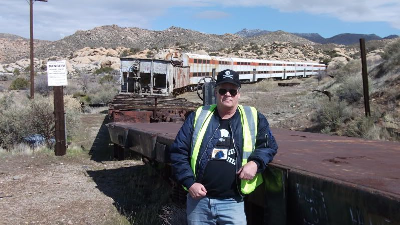
<em>edited by dsefcik on 2/26/2012</em> |
2/27/2012
Topic:
Creosote is older than Redwoods and Bristlecones
dsefcikAdministrator
|
An amazing article about Creosote
http://www.kcet.org/updaily/the_back_forty/commentary/in-the-old-growth-desert.html
From the last paragraph:
"If the 1200-year-old creosote where I sat were a redwood tree in a park it would have a plaque nearby, and travelers would come for miles to gaze at it reverently. If it were a coast live oak it would have died of immense old age a thousand years ago. If this creosote bush were a tree of like age and people came to cut it down for some industrial project, photos of it would flood the Internet with outraged commentary about our species' soulessness, and people would line up to be arrested in order to protect it. But it's a creosote bush, not a grand sequoia, and so it sits here in obscurity, scraping by in dry years like this one and putting out flushes of growth in the wet, and if we manage not to uproot it it may still be doing so when all memory of our fleeting civilization has been forever lost." |
2/27/2012
Topic:
Creosote is older than Redwoods and Bristlecones
dsefcikAdministrator
|
He has a lot more good reading here http://www.kcet.org/user/profile/cclarke |
2/27/2012
Topic:
Moan, Puff, Groan and Gasp
dsefcikAdministrator
|
Great views of the trestle! Groan had to be bitch, I have come down a few times just south of it and I always look up at it thinking it is way too steep. Great TR and maybe I can make it out next time with you guys, it just didn't work out for me this weekend.
Daren |
2/28/2012
Topic:
Moan, Puff, Groan and Gasp
dsefcikAdministrator
|
surfponto wrote:
Must be Border Patrol
According to Daren they use the military copters.
They have un-permitted sensors in the gorge and it is possible you tripped one, I know it seems like almost every time we are down in the gorge they fly overhead.
This is from the last time we dropped down in from Sacatone
 |
2/28/2012
Topic:
ABDSP Via Sunrise HWY
dsefcikAdministrator
|
The PCT runs thru that area. I used to run ultra races and many of the courses went thru Lucky 5 down/up Oriflamme and over to Banner. One race started at Pinyon Wash and headed over thru Blair Valley, up Oriflamme and ended in Cuyamaca. We would also use the jeep roads, I know those trails pretty well.
Just like other parks, ABDSP continues to acquire land and it is not always available for public use until it is determined how human impacts will effect the area and what the best use for the land will be...that is my guess.
With a nice rig like yours a camping trip up to the snow would actually be enjoyable...nice! Thanks for sharing those pictures! |
2/28/2012
Topic:
ABDSP Via Sunrise HWY
dsefcikAdministrator
|
BTW, you can download a map of abdsp and it shows the boundaries pretty well:
http://www.parks.ca.gov/pages/638/files/ABDSPmap.pdf |
2/28/2012
Topic:
ABDSP Via Sunrise HWY
dsefcikAdministrator
|
Some more good reading regarding this and other land acquired for abdsp
http://theabf.org/what_we_do/saving_land/protected_land
http://www.parks.ca.gov/pages/638/files/anza-borrego%20desert%20state%20park%20magazine.pdf
San Felipe Valley
http://www.parks.ca.gov/pages/638/files/anza-borrego%20desert%20state%20park%20magazine.pdf |
2/29/2012
Topic:
Canebrake Canyon Access
dsefcikAdministrator
|
Canebrake is private property, you would have to ask permission to access the area. Hiking or helicopter is your best bet. |
3/1/2012
Topic:
ABDSP Via Sunrise HWY
dsefcikAdministrator
|
There is a dirt road that goes straight down thru Oriflamme out to the S2. Before it drops down into Oriflamme it also branches off north towards Banner. you can see old mining/milling sites out there, very interesting area. |
3/2/2012
Topic:
Mortero Palms
dsefcikAdministrator
|
x eagle, do you have any more info about the history or meaning of the wagon wheel?
it looks like it is located next to a fairly large runoff, like it may not have much time left as the soil erodes. |
3/3/2012
Topic:
Cougar Canyon Conditions?
dsefcikAdministrator
|
Definitely looks like a nice area, any other hikers out? |
3/4/2012
Topic:
Trains and Pictographs in Carrizo Creek
dsefcikAdministrator
|
anutami wrote:
Found a cool article on native American dyes http://mydesertmagazine.com/files/194503-DesertMagazine-1945-March.pdf
Starts on pg 20
That seems to mostly talk about dying string,yarn, etc for fabrics. I wonder if those materials and techniques also worked for rock art.
Don't forget to also read Marshal South's Desert Refuge article, that one is one of my favorites and you can also see the South children wrote a letter to the editor thanking the donor of their tortoise. |
3/5/2012
Topic:
Solo Backpacking in Rockhouse Valley
dsefcikAdministrator
|
looks fun..I have not been there (yet) but I think maybe you needed to go north west a bit more up to the top of Nicholias Cyn. I believe there are more ruins east of there also. I have been wanting to do this trip for a couple years now, maybe over Spring Break.
<em>edited by dsefcik on 3/5/2012</em> |
3/6/2012
Topic:
Cougar Canyon Conditions?
dsefcikAdministrator
|
bobmc wrote:
the gate is closed june 1st to september 30
Bighorn Sheep drinking period.... |
3/6/2012
Topic:
Canebrake Canyon Access
dsefcikAdministrator
|
bobmc wrote:
Just the mouth of canebrake at crawford ranch is private. You can access it from moonlight canyon, an unnamed drainage from inner pasture, the north fork of Indian canyon or the pepperwood trail from mc cain valley. It is actually illegal to land a helicopter in blm wilderness in including the sawtooth mountain wilderness study area which covers canebrake inner pasture and el potrero canyon
Those are all the popular and most used routes in. I am curious, do you have some reference material about landing a helicopter on blm wilderness in the areas you
referenced? |
3/6/2012
Topic:
Canebrake Canyon Access
dsefcikAdministrator
|
bobmc wrote:
http://www.blm.gov/ca/st/en/prog/wilderness/wa/areas/sawtooth_mountains.html
under addtional information
While that reference is very vague I did find more specific reference to helicopters in other blm materials. Thank you for pointing that out, I will be sure to relay this information to the pilot who we flew with and make note for any future flights. |
3/7/2012
Topic:
Trains and Pictographs in Carrizo Creek
dsefcikAdministrator
|
I don't get it..those photos are old and the story doesn't really say much...what did I miss? |
3/7/2012
Topic:
Trains and Pictographs in Carrizo Creek
dsefcikAdministrator
|
The meta data on them says 04-19-2011
Besides, look at the below photos, the one from his site shows him standing next to the no trespassing sign **on the pole** and the one I took a few weeks ago is you **holding** the sign that was on the ground. You are standing just to the right of the pole (which is out of the picture)
---

surfponto wrote:
How do you know how old the photos are?
dsefcik wrote:
I don't get it..those photos are old and the story doesn't really say much...what did I miss? |
3/11/2012
Topic:
Calcite Mine Slot Canyons
dsefcikAdministrator
|
damn mylar balloons..we will rid the desert of them one-by-one...
i do not recognize some of those canyons, do you have a map of where you went exactly? i was out in the canyons a couple years ago but is was more on the west side of the calcite mine road. |
3/12/2012
Topic:
Calcite Mine Slot Canyons
dsefcikAdministrator
|
anutami wrote:
Still trying to figure out how to do the google map screen shot w/ the route, but It looks like I went through Palm Wash.
I just import the .gpx file from my gps or phone app into google earth and then under the File menu I select Save > Save Image
You can use gpsbabel to convert all kinds of gps formats to/from google earth, download it here http://www.gpsbabel.org/
When I went I went up south palm wash and then came down thru the middle palm wash. Some of you rphotos look familiar, like the ladder drop off..except there was no ladder and I also don't remember there being any rope. Here are some pics from the trip I did http://www.sefcik.com/2011/01/smoke-tree-canyon-calcite-mine-area.html |
3/21/2012
Topic:
San Felipe Valley / Plum Canyon / Yaqui Well
dsefcikAdministrator
|
Nice TR..thanks for sharing. While most of the time I (and others) always seem to focus on the "big" hikes or trips, we never stop to check out the smaller ones. All those places you went I have driven by a million times and said "I need to go check out Plum Cyn" or the Yaqui trail. Maybe over break I will spend a day stopping at some of those.
BTW, the PCTA and ABDSP have purchased more land for the park http://www.eastcountymagazine.org/node/9082
Daren |
3/22/2012
Topic:
San Felipe Valley / Plum Canyon / Yaqui Well
dsefcikAdministrator
|
herofix wrote:
By the way, how did you map out your route and distance? Is a GPS required for that, or can you use a pedometer or similar device? I'd love to know how far I go each time.
Thanks.
Most people will use a GPS but if you have an iPhone or one of the Android phones you can use an app to do all of your GPS/Mileage tracking. |
3/23/2012
Topic:
Mortero Palms
dsefcikAdministrator
|
Here is a great article about Ocotillo and the wind energy project we trying to stop, it has a nice a photo of the spoke wheel geoglyph.
http://www.eastcountymagazine.org/node/9104
If you haven't already signed the petition you can do so now here http://www.change.org/petitions/say-no-to-the-ocotillo-wind-energy-facility-project |
3/26/2012
Topic:
Coyote Canyon "Boulder Alley"
dsefcikAdministrator
|
Thanks for the update, did you do this in your truck/camper rig? I know in my truck those boulders make a really bumpy and slow ride. |
3/26/2012
Topic:
Coyote Canyon "Sea of Red"
dsefcikAdministrator
|
That looks nice..I am hoping to get out over the next two weeks for spring break but the pneumonia I somehow contracted 5 weeks ago is still lingering on me. I may have to rely on everyone else to report the desert blooms this year. |
3/26/2012
Topic:
Oriflamme Canyon
dsefcikAdministrator
|
Check out the ABF 2012 1'st place desert landscape photo winner's photo: http://theabf.org/2012_photo_contest_winners#137
Look familiar??
 |
3/26/2012
Topic:
Coyote Canyon "Boulder Alley"
dsefcikAdministrator
|
DHeuschele wrote:
It looks a lot easier than when I was last up it a few years ago. It looks like some of the biggest rocks have been either removed or broken into smaller pieces.
Last time I was up there is would be a real challenge for most stock 4X4 SUVs. Now it looks like most stock 4x4 SUVs should not have much difficulty.
I think in another thread somebody mentioned that the cal fire crews blasted the road away to get at a fire and it is now easier to pass.
http://www.anzaborrego.net/travel/anzaborregoprevious/forum/topic222-cougar-canyon-conditions.aspx |
3/26/2012
Topic:
Coyote Canyon "Boulder Alley"
dsefcikAdministrator
|
kylekai wrote:
I really enjoy reading about these adventures. However, most times I am not really sure where the particular trail or road is located within the park. It would be great if these types of stories would include a Google map link. Is that possible? Thanks!
Pretty much here http://caltopo.com/map?id=133U
You may need to zoom out a couple notches... |
3/30/2012
Topic:
Mortero Palms
dsefcikAdministrator
|
I have not but they are in Blythe not too far away and they are open to visitors
http://www.blytheareachamberofcommerce.com/intag.htm
mrkmc wrote:
Anyone ever seen this in person? Looks interesting.
 |
4/1/2012
Topic:
2012 Wildflowers are beginning to bloom
dsefcikAdministrator
|
The wildflowers are starting to come out, this wildflower report is the segue to a couple of trip reports I will post next.
These photos are from last week 3-27-2012 - 3-29-2012
Hedgehog Cactus - Carrizo Gorge

Beavertail Cactus - Mason Valley

Desert Apricot - Mason Valley

Yucca - Mason Valley

Brittlebush - Mason Valley

Teddy Bear Cholla - Carrizo Gorge (near dusk photo)

Golden Suncup - Carrizo Gorge (near dusk photo)

Ocotillo - Red Hill

Beavertail Cactus with a bee covered in pollen - Red Hill

Ocotillo - Ocotillo Wind Energy Project Site Area, this will be destroyed if this project goes thru

Ocotillo - Ocotillo Wind Energy Project Site Area, this will be destroyed if this project goes thru

http://www.sefcik.com/2012/04/wildflowers-are-beginning-to-bloom.html
<em>edited by dsefcik on 4/2/2012</em> |
4/2/2012
Topic:
2012 Wildflowers are beginning to bloom
dsefcikAdministrator
|
hikerdmb wrote:
I am glad you finally feel well enough to get back out there. Can't wait to see your TR.
David
Thanks..cough, cough...I am still not well but I could not stay home during my break, I think I am heading back out tomorrow to backpack into Canebrake if anyone is interested. While the doctors still try and *guess* what is wrong with me I am moving on with my life (albeit coughing and lung pain). They said at first pneumonia but xrays and other tests proved negative, going on 8 weeks of this crap now...anyway, enough of that....the TR is kinda lengthy so it will be tonight or so. |
4/2/2012
Topic:
Carrizo Gorge / Mason Valley / Red Hill
dsefcikAdministrator
|
I have a pretty long list of places I keep telling myself I will stop and check out "one of these days" and this week I knocked out a few of them. First stop was Carrizo Gorge, among other reasons for the visit I wanted to get some pictures of the pictographs with my good camera. ABDSP is really stepping up the efforts in Carrizo Gorge, they have recently added many new big, thick wooden posts and signs blocking access to the Rockhouse Canyon road, many self made side trails/roads and also at the end of the road itself. These are all for the better, people have been driving off the road in too many places damaging many parts of the gorge. Tamarisk removal is also obvious, the road is almost void of brush scraping your vehicle.
According to Stellarium, this photo shows the Moon, Venus, Jupiter, Orion, Sirius, Pleiades star cluster (M45) and more. Sombrero Peak is in the far distance just to the right of the tree, False Sombrero can also be seen further to the right - Carrizo Gorge

Teddy Bear Cholla Wildflower - Carrizo Gorge
Pictographs in Carrizo Gorge

---

Three coyotes walked up to my campsite near dusk while I was reading, I broke one of my own rules by not having my camera with me so the next best thing is the prints they left (starting in the bottom right corner going to the top left). You can see how close they came up to me. They really had no fear or concern about me, we made eye contact and then they calmly continued on their way - Carrizo Gorge

Mason Valley is one of those places I drive by all the time and have wanted to go check out. I spent almost all day wandering around the valley and still did not see everything I wanted, I did not get over to check out the old mines for example. Technically Mason Valley (where I went) is private property owned by the Butterfield Ranch and BLM land. When I was out on the trail I had the opportunity to meet the owner of the Buterfield Ranch and help her with horses and some riders with her. I really liked the area. All the photos from Mason Valley can be seen here
Some great old vehicles and farm equipment at the Butterfield Ranch

---

---

---

---

---

Out in Mason Valley there is an old rockhouse built into the hills that I believe early ranchers used. I really had a hard time finding much information about it

This is a dugout in the corner of the house that was probably used for storage or a dry shelter when raining

This is looking out the front door into the valley

This must be where the stove or fireplace must have been, you can see the steel exhaust vent pipe above and it channels out to the chimney outside

This is a small dam next to the rockhouse, it was used to block a small stream nearby

Indians definitely favored Mason Valley, there are some great morteros in some interesting rock

Somebody must know why animals love to leave their crap in holes in the rocks

I found several cupule boulders in the valley

There was pottery in the area also, including this very thick, large piece

Here is a very interesting rock wall that hugged the edges of a wash, it was much, much longer than what the photo shows

There were many wildflower blooms in the valley, you can see more wildflowers here
Desert Apricot - Mason Valley
Beavertail Cactus - Mason Valley
Making my way back home I stopped to climb Red Hill. I swear I have told myself a million times I would stop and climb it real quick before going home..well that was today.
From the S2 highway looking at Red Hill in the distance

As I neared the summit the terrain turned to mostly volcanic boulders and required using my hands to get up

Here we go again, scat in a nice hole in the rocks near the summit

On the summit of Red Hill looking towards Ocotillo. If the Ocotillo Wind Energy Project succeeds this view will be of 150+ 450' tall Wind Generators

The last entry in the register was over a month old

Some beautiful blooms were on the sides of Red Hill
Ocotillo - Red Hill
Beavertail Cactus - Red Hill
Gorgeous Ocotillo blooms were everywhere - Red Hill
---
Happy Sweet Sixteen little darling...total mylar balloons this trip - 6

Sunrise Powerlink laydown area in Ocotillo. This is what is left now that they have finished and gone. It will take thousands of years for the "Restoration" to return back to the way it was before SDG&E raped the land...way to go SDG&E!

Well, that's all I got for this trip, hope you like the pictures.
http://www.sefcik.com/2012/04/carrizo-gorge-mason-valley-red-hill.html
<em>edited by dsefcik on 4/2/2012</em> |
4/2/2012
Topic:
Coyote Canyon "Boulder Alley"
dsefcikAdministrator
|
kylekai wrote:
I'm in Arizona now, driving the Apache Trail (east of Phoenix). Terrain similar to AB. Campgrounds are virtually empty during the week. Nice to get out of the big city.
-Bill
Would love to see some pics and maybe more detail of the area...! |
4/2/2012
Topic:
2012 Wildflowers are beginning to bloom
dsefcikAdministrator
|
svcheerio wrote:
Gorgeous pictures as always from you! We can't wait to get out there this week!
Thanks, if you are near Blair Valley again, maybe go check out Rainbow Canyon, Schad recommends it for wildflower blooms..I am going to try and go have a look this week. |
4/3/2012
Topic:
Butler/Jackass Flats/Village/Rockhouse Canyon Loop
dsefcikAdministrator
|
I have had that same area on my list to do for awhile now, I would love to see some pics from Butler canyon. |
4/3/2012
Topic:
Carrizo Gorge / Mason Valley / Red Hill
dsefcikAdministrator
|
surfponto wrote:
I know we have talked about this before but the road up to Rockhouse Canyon was a legitimate jeep road back in the day.
The portion up to the BLM border was and still is a well outlined two track jeep road.
They have put up numerous big wood posts all along the Rockhouse Cyn entrance area. Down towards the end of the road also are many, many new posts and right at the end of the road before it crosses the stream they basically posted that all up and made a parking lot right where we parked last time when we went. Not a bad thing really but the road is much easier to travel now, I only got a couple of scrapes. |
4/3/2012
Topic:
Carrizo Gorge / Mason Valley / Red Hill
dsefcikAdministrator
|
surfponto wrote:
Are you talking about a parking lot here?
No, at the very end of Carrizo Gorge rd, about 6 miles in. I say parking lot because the whole area is so cleared out from constructing the 30 or so fence posts it looks like a parking lot. |
4/3/2012
Topic:
Carrizo Gorge / Mason Valley / Red Hill
dsefcikAdministrator
|
surfponto wrote:
As far as RH Canyon is it marked at the junction with Carrizo Gorge?
No, they have put up posts all over the RH area also, the wood posts are everywhere now. |
4/7/2012
Topic:
Indian Valley / June Wash / Diablo BM
dsefcikAdministrator
|
Like many of my trips to Anza Borrego Desert State Park I usually will have one thing I am going out to do and then I will usually find other things along the way to do also. This trip involved photographing some pictographs near the In-Ko-Pah mountain range. Using Indian Valley as my base camp I packed up my gear and was ready for a 2 day backpack trip to try and find the pictographs. The weather was great and I only saw a few cars the first day I arrived and then only a single person when I left, none of them were camping.
The pictographs proved to be worth all the effort, here are few photos of them.
DStretched enhanced circle motif

I have seen some refer to these next two pictographs as the Xray pictographs

---

DStretched enhanced version

To learn more about pictographs in Anza Borrego Desert State Park pick up a copy of Manfred Knaak's book The Forgotten Artist: Indians of Anza-Borrego and Their Rock Art
Before heading back to Indian Valley I figured I would summit False Sombrero, it has been just over a year since Scotty "C" and I went up there.
Looks like the Cliff Bar and the Cholla Ball Combs we left are still in the jar
***mrkmc*** looks like I am just following your trail lately, finding your name in the peak registers, Red Hill, False Sombrero (you are in this photo), Diablo BM..we will meet again...8-)

And someone may have actually used Scotty's combs!

One small dime sized macro wildflower bloom in Indian Valley before I left

Before going home I decided to go over to June Wash and try to hike up and over to Sandstone Canyon as described in Jerry Schads book. The effort proved too much for me after the backpack trip and I stopped at Diablo BM instead and called it a day. It was still a great hike and the views were awesome, recommended hike for sure to anyone thinking about it. Do read the trip description in Jerry's newest edition unlike myself. I only took his 1986 copy and the description was outdated and I ended up hiking the wrong wash.
June Wash sign at the S2 turn off

Heading up June Wash, it is easy going for the first 1-1/2 miles or so and then it gets bouldery

The Diablo BM register

Heading back down June Wash, Sombrero Peak waaaayy off in the distance

Here are links to (2) 360 degree panorama images from Diablo BM. One is just the view and the next is the view but with landscape features annotated for reference. I recommend you download the full versions of the photos and zoom in and pan around, they are about 22MB each.
View only - Download full version

View with landscape features - Download full version

Congratulations, it's a boy! - From The Desert

Total Mylar Ballons this trip - 2
Total old faded beer cans - 2
--
<em>edited by dsefcik on 4/7/2012</em> |
4/8/2012
Topic:
Coyote Canyon "Boulder Alley"
dsefcikAdministrator
|
Wow..that Apache Lake photo is awesome, looks like it came out of a cowboy movie! That looks like a great place, I need to get out more often..thanks for sharing! |
4/9/2012
Topic:
Indian Valley / June Wash / Diablo BM
dsefcikAdministrator
|
mrkmc wrote:
I saw https://picasaweb.google.com/112918892253657164707/VallecitoMountainsHighpointDiabloBenchmarkAndSplitMountainWest#5687693483869747058" target="_blank" rel="nofollow">this business card in the register and later found a great story in Desert Magazine (see page 4) about the park superintendent and Leo exploring Sandstone Canyon for the first time. I imagine the card was left in the register around that time.
Yeah, some of the less visited peaks have some neat old entries in them, Grapevine had some old ones in it. I love the sentence in that article you referenced "The trip could be made in a Model T or later in a Model A"....guess I need to trade in my truck... |
4/9/2012
Topic:
Bighorn Sheep Sighting in Anza Borrego
dsefcikAdministrator
|
Were the BHS near the freeway in Ocotillo? Looks like the same group spotted a few weeks ago. The metal debris also hints at roadside proximity. |
4/9/2012
Topic:
Indian Valley to Julian via the Mason Truck Trail
dsefcikAdministrator
|
We used to do an Ultra Race (Lost Boys 50) that went from Pinyon Wash to Green Valley in Cuyamaca. The course went up Oriflamme and I can remember one race when a million jeeps came roaring up the canyon, it was a dusty mess.
It is really interesting to see how much more green your Ocotillos have then when I was out there 2 weeks ago, the green was just starting to come out on them when I was there.
Is this Indian Paintbrush?
 |
4/10/2012
Topic:
Where the wild flowers weren't.
dsefcikAdministrator
|
Very nice TR..! Can't wait to see what you find when you take your wife out to see bighorn sheep.....I agree with Bob, that last photo is awesome. |
4/12/2012
Topic:
Archaeology Weekend 2012
dsefcikAdministrator
|
For anyone interested in the archaeology of ABDSP the The Colorado Desert Archaeology Society's 9th Annual Archaeology Weekend event is this weekend.
Complete details are on the ABF website http://theabf.org/event/archaeology_and_history/archaeology_weekend_2012
-- |
4/16/2012
Topic:
Exploring The Island and Myer Valley
dsefcikAdministrator
|
mrkmc wrote:
Another area I still need to check out. There are 3 benchmarks "on the island" that I want to check out, Devil, Inko, and Pah
What map do you see those on? My USGS topos only show 7 unamed BM's. |