11/14/2011
Topic:
Indian Hill Trip
X EAGLE 23 X
|
Hi all, I'm semi-new here, been around a while just never got around to posting. Made my third trip out to Indian Hill on Friday to do some exploring and take a closer look at some of the pictographs. On the drive out I straddled a small black object and turned around to find that it was this guy trying to cross the road. So I took some pictures and made sure it got off the road safely before continuing on.
[IMG]http://i978.photobucket.com/albums/ae261/Menvielle/IMG_4333.jpg[/IMG]
I have visited the site before and went through my pictures prior to this trip in order to make a mental list of specific pictographs I wanted to take a closer look at, as well and find some other loci (locations) of others which had been reported by some of the earlier archaeologists. After some wandering around I found one other set of them:
[IMG]http://i978.photobucket.com/albums/ae261/Menvielle/IMG_4525.jpg[/IMG]
This panel appears to be two (headless) stick figures, the left with exaggerated arms/legs.
[IMG]http://i978.photobucket.com/albums/ae261/Menvielle/IMG_4391.jpg[/IMG]
After that I climbed to the top of the hill and to my surprise discovered an interesting small rock shelter as well as two cupule holes.
[IMG]http://i978.photobucket.com/albums/ae261/Menvielle/IMG_4482.jpg[/IMG]
The opening has some strange markings near the top (yellow/reddish color in the picture), but after running it through DStretch it appears to be natural and not man-made.
[IMG]http://i978.photobucket.com/albums/ae261/Menvielle/IMG_4485.jpg[/IMG]
Here is one of the cupule holes at the top (boot for scale)
While in the process of climbing to the top I came across this small campsite where someone lit a small fire.
[IMG]http://i978.photobucket.com/albums/ae261/Menvielle/IMG_4466.jpg[/IMG]
I then decided to search for the "tank" which I had read about in an earlier thread here. I spotted its possible location while at the top of Indian Hill and went to investigate it and found it was completely empty except what appears to be a small spring which feeds it.
[IMG]http://i978.photobucket.com/albums/ae261/Menvielle/IMG_4639.jpg[/IMG]
I was quite surprised to find multiple grinding areas around the tank, and while checking these out two vultures began to soar over us
[IMG]http://i978.photobucket.com/albums/ae261/Menvielle/IMG_4648.jpg[/IMG]
We headed back to the jeep and jumped a few jackrabbits on the way and on the drive through Motero Wash on the way back to S2
[IMG]http://i978.photobucket.com/albums/ae261/Menvielle/IMG_4704.jpg[/IMG]
It was a good and successful trip. I managed to squeeze behind the main rock shelter and found it to be full of mountain lion scat, so be very careful in that area, it is obvious that the lions are active and visit the area on a regular basis.
Jordan |
11/15/2011
Topic:
Indian Hill Trip
X EAGLE 23 X
|
I'm not sure if it was a spring or not, and I checked out the topo maps after I posted and noticed there was not one placed on the maps. There was very little water but the sides were obviously damp and a tiny bit was in the little hole which is why I speculated it could be a spring. But I'm not sure it could have been the tiny amount of water left and it would make sense it would be in the lowest point of the tank. Here are a few more close up pictures of it.
[IMG]http://i978.photobucket.com/albums/ae261/Menvielle/IMG_4651.jpg[/IMG]
[IMG]http://i978.photobucket.com/albums/ae261/Menvielle/IMG_4655.jpg[/IMG]
dsefcik, you are correct that panel is not in the main pictograph room but is nearby. I find it interesting that they are stick figures since none of the other anthropomorph's are stick. Not sure if this means they were painted at a later time or perhaps a different artist is responsible for them, or it could be some other reason.
You're a lot braver man than I am Bob! Great picture |
11/16/2011
Topic:
From the Unpublished Series
X EAGLE 23 X
|
That's an amazing picture! Was this taken on the summer solstice? |
11/16/2011
Topic:
Indian Hill Trip
X EAGLE 23 X
|
Haha while that is where I learned about the tank, I didn't plan on taking a similar picture that was just coincidence. |
2/7/2012
Topic:
Carrizo Gorge Canyon - DeAnza to Egg Mtn
X EAGLE 23 X
|
That lizard pictograph is actually in Professor Knaak's book, "The Forgotten Artist" which is a great book about rock art in the Anza Borrego. That sunburst picto is a very interesting polychromatic color, very cool finds! |
2/22/2012
Topic:
Mortero Palms
X EAGLE 23 X
|
Yeah, that's not the wagon wheel, it looks like it could be some sort of calendrical or orientation marker. Does it seem the linear rocks are pointed in any particular direction? The large amount of pottery in the circle is strange too. Awesome find! |
3/2/2012
Topic:
Mortero Palms
X EAGLE 23 X
|
anutami wrote:
I am pretty sure the linear rocks point north, south, east and west, but not sure if they are dead on. I did not check it with my compass and should have. I also should have tried to count the rocks in the circle to see if they are near the calendar year. I guess I could pull up some of my photos and try and count.
The fact that many of the rocks are half buried in the ground support the fact that this is quite old and probably done by Native Americans. The Kumeyaay did have a sense of the cardinal directions, so they quite possibly could point in those directions. But they did not have a calendar year like ours, instead they had a 2 part 6 months (lunar) calendar. This alignment probably served as some sort of ritual or religious ceremony.
It's interesting to note that this has some similarities with the 'spoked-wheel' rock alignment such as pottery spread within the alignment and quartz rock (which was a 'powerful' rock) being used in its construction. Here's a pic of the spoked-wheel:
[IMG]http://i978.photobucket.com/albums/ae261/Menvielle/IMAG0114.jpg[/IMG] |
3/3/2012
Topic:
Mortero Palms
X EAGLE 23 X
|
My understanding is that the history of it is somewhat up in the air and puzzling. While the general design is somewhat common in rock art (pictographs and petriglyphs), the nearest rock alignment is found way down on some island in the Gulf of California. Of course that simply means we haven't found any nearer alignments, it doesn't mean they aren't out there.
The likely meaning of it is that it was a ritual or religious site. The Kumeyaay believed quartz had special powers (if you've ever rubbed two pieces together you know why haha) and so it's obvious association with both these rock alignments points to some sort of ritual/religious significance. I know some have suggested each 'spoke' is a representation: one for each direction (north south east west); one for Mother Earth; one for Father Sky; one for all living things. But I think that could be stretching it a bit too far and connecting dots without enough evidence. I think the truth is, we just don't know what exactly it was or why it was constructed. |
5/30/2012
Topic:
Memorial Day Weekend: Palo Verde/Blythe Intaglios
X EAGLE 23 X
|
tommy750 wrote:
ziphius wrote:
Those intaglios and panels are amazing. Anyone know the estimated ages on them?
From the little I've read, seems like the estimates are quite variable. Up to thousands of years ago. Tom
I'm not sure about the geoglyphs, but the petroglyphs are quite tricky to attempt to place a date on. The reason why the dates being thrown around are so variable is because it appears they were probably carved over a long period of time due to the different styles (lightly pecked, deeply pecked, broad lines, geometric elements, etc). Adding to the problem is the fact that these were carved into Limestone panels which is much more difficult to date than the basalt (which they usually are carved into), but they're thought be from about 500ad - 1500/1600ad. Some have suggested the earliest carvings could be from the archaic period which is from 5000-2000bc, but that's a huge stretch and not very well supported if you ask me. |
6/26/2012
Topic:
Squaw Tit and Table Mountain
X EAGLE 23 X
|
tommy750 wrote:
Apparently water drains off these luxurious patios (visible from outer space) and fill nearby cisterns. Little animals then have extra water. Daren, do these things really work?? Seems a little overkill to me. Tried to find "Post 376" but only located a Troop 376 in nearby Milwaukie, Oregon. Was going to lift the metal plate off the cistern and check out the water level but the heat kinda sapped my curiosity.
I did some work for BLM a few years back and they had me looking for those guzzlers all over Imperial county from the base of the Jacumba mountains, to the Chocolate mountains. I came across one in the Yuha Desert during May one year and it was quite full of water (along with a ton of sand at the bottom of the cistern) and had a lot of tracks around it. So the ones that are still in existence (some have been destroyed over the years) do work and are used by the wildlife.
That's an awesome pic of the power line! How'd you do it? |
6/26/2012
Topic:
Squaw Tit and Table Mountain
X EAGLE 23 X
|
dsefcik wrote:
I forgot to ask X EAGLE, do you know why the metal bars are bent up or broken out on some of them?
You mean the metal bars at the opening of the cistern? Probably just damage and due to neglect; I once found one in the Chocolate Mts. that literally had nothing left but a metal bar sticking out of the ground (Flash flood must have destroyed the rest). The guy I was working under said most were built 30-40 years ago, then forgotten about and he was having me find and mark their GPS coordinates so they could then go out and repair them but unfortunately he transferred to NorCal so I doubt that will happen.
That's really neat Tommy! It really gives the pictures a different feel and brings out some of the details in them |
4/3/2013
Topic:
Cedar Creek Falls to Re-Open
X EAGLE 23 X
|
I did this hike a few years back and it was a ton of fun. We went a day that the surrounding area was being hit with a snow storm which meant the water levels of the San Diego river and Cedar Creek were high (Cedar Creek was too high to cross). We ended up not being able to make it to the bottom of the falls so we went on a trail to the left which took us to the top. My understanding of the guy who died at the falls was that he didn't "fall" off but rather jumped off. It's a popular party spot and unfortunately a few people make bad decisions and ruin it for the rest of us.
Sounds like the lawsuit is about keeping it closed until more safety measures can be put in place.
Here's a picture of me crossing the San Diego river, notice the water level is knee/waste high
 |
6/3/2013
Topic:
The reason you rarely find mortars with morteros
X EAGLE 23 X
|
Not only is it disheartening, but it's also ILLEGAL |
10/14/2013
Topic:
Indian Hill Trip 10/5/2013
X EAGLE 23 X
|
Well it must be that time of year again; weather is finally cooling down and it's bearable (dare I say nice) to be outside and out wandering in the desert again. This past summer I came across a program which "stitches" photographs together and I was eager to take some photos and test the program out. So last week I decided to hike out to Indian Hill to take some new pictures specifically to run through the program and see how well it works and I'm quite pleased with it. The program is called "Hugin Panorama Stitcher" and can be downloaded from the internet for free.
As some of you may be beginning to think, Indian is one of my favorite spots due to it's easy access (except for that one part just past Dos Cabeza's), quick hike, and tons of stuff to explore.
Here's a stitched photo:
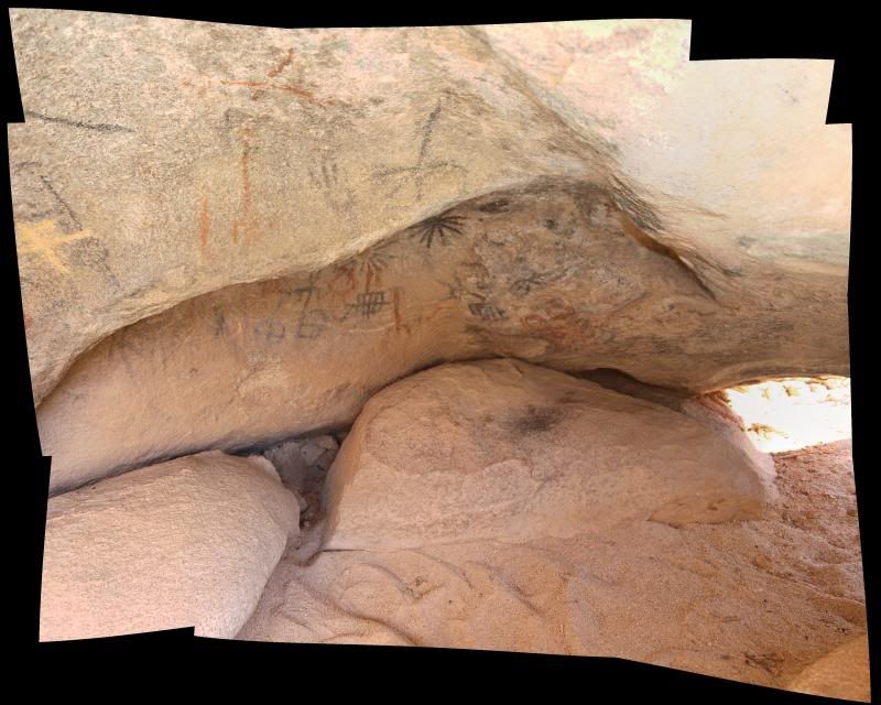
While the image doesn't appear to be anything special at first look, but it allows a person to take multiple detailed photo's ( the above is actually 11 photos) of an object and then put them all together and view the entire object, while being able to zoom in and see details which you normally wouldn't be able to see if you just took one photo of it. The most photo's I've stitched so far is 38, but couldn't get it to upload to photobucket (maybe too big?) to post here.
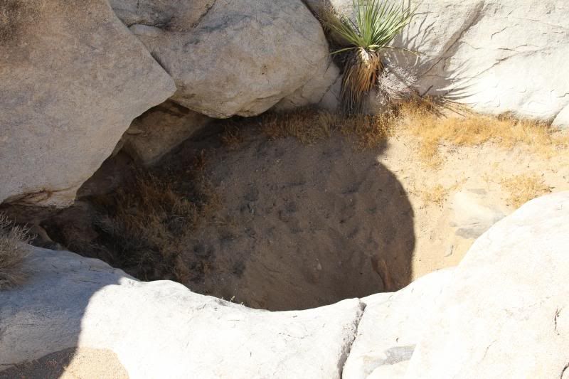
While out there I swung by the "water tank" and was surprised to see it bone dry. Figured with all the rain we had gotten last month there would be at least a little water left in it, but there was nothing. I hiked a little further up and couldn't find any traces of recent water.
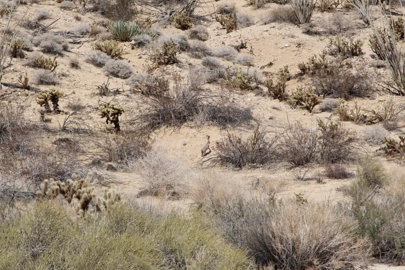
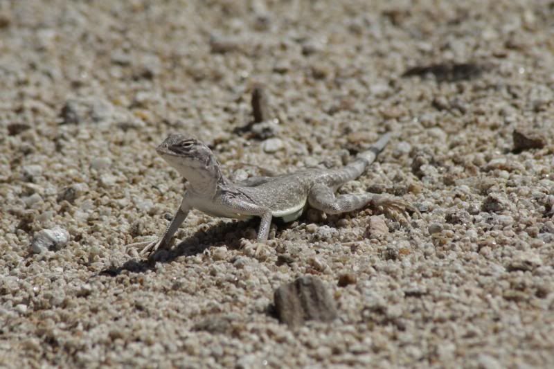
While hiking around the area, lots of jack rabbits and little zebra tailed lizards running all over the place. Couldn't get a good shot of a jack rabbit, but finally got in close enough for a few decent photo's of a lizard.
All-in-all it was a great trip, weather was pretty nice for the most part except for a few times when the slight breeze stopped blowing. Only spent around 3 hours out there and the only people I saw were a group of bikers who must have followed the train tracks down through the mountains. |
10/16/2013
Topic:
Indian Hill Trip 10/5/2013
X EAGLE 23 X
|
I figured the lizard was a zebra tailed lizard because of the striped tail. Here's a picture taken from a different angle which shows it better:

89 photos?! Did it automatically align them all, or did you have to add some control points manually?
The tank is just to the south of the pictographs. There are more motero's and broken pottery around it and I had read about a water source in the area so thought this was it, but either it's no longer reliable or the water source is just somewhere else.
I turn off S2 just past the border patrol checkpoint outside of Ocotillo and took Mortero Wash Rd. all the way down to Dos Cabeza's train loading area. The first stretch of Mortero Wash is quite bumpy, but it's a solid rd and even when in the wash it's not too soft. I didn't use 4wd at any point on that road. And the road from Dos Cabeza's to where I park wasn't bad except for the one part where you have to climb up out of the wash. It seems the summer rain made this steep climb a little worse and the holes are deeper so it's harder to navigate up it. I tried once without 4wd and couldn't do it so just threw it in 4wd and then didn't have a problem (but it sure was bumpy). I've seen people park at the bottom and just hike all the way in from there and it only adds an extra 2 miles roundtrip so it's not too bad. |
10/18/2013
Topic:
Indian Hill Trip 10/5/2013
X EAGLE 23 X
|
That stitched panorama looks really good, it's pretty neat how it's a full 360 view from top to bottom!
Is the bypass road the one that leads to the north then somehow turns back around and meets back up with the main road just above the big holes? I've always wondered where that road went but never found the time to explore and follow it. Good to know there's a way to bypass ugly part! |