1/16/2024
Topic:
Indian Gorge Campout
Brian
|
Rocko1 wrote:
Nice boa. I have only seen one also, near Pinyon Mtn Rd years ago. Shockingly I see very few reptiles.

I saw one like that on my solo trip to Alta Seca Bench. Not sure whether I remembered to tell you about that when we went there. |
1/16/2024
Topic:
My Retriement
Brian
|
Great pics and I wish you luck in your new home. If you (when you're in town) or Gary would ever like a hiking companion, I'd like to apply for the position. |
1/21/2024
Topic:
Four Frogs Canyon
Brian
|
The Four Frogs / Jacumba Jim loop in Schad's book looks like a real slog (starts from the top in McCain Valley). I haven't ruled out doing it some day, but it's definitely not at the top of my list. Never thought of going up from the bottom. Anything interesting there? |
2/1/2024
Topic:
Sad News about Anza Borrego
Brian
|
https://theabf.org/coyotecanyon/?fbclid=IwAR10wGfpDTNV6xwX-E8oTH9IjHezzu_hefkgaAg1frVrFSVPdP9SgnmJTVw_aem_AbVH8XuZ26ONyXw95cAF01zTppguxg8ne9HXsOhZv7ShzGlYwAY6SahOfqJ3Hg9ZHrk
Looks like there is a plan to reopen the road, but it will take a while. |
2/3/2024
Topic:
Anza Borrego Egg Mountain
Brian
|
Nice pics. Sometimes the sky is so beautiful out there. |
2/12/2024
Topic:
Sandstone Canyon question
Brian
|
I might do that, but first I'm going to try doing a return trip to look again. I'll be better prepared next time. I think I've figured out where to look from the adjacent pics. |
2/14/2024
Topic:
Little Blair North
Brian
|
We only saw one other hiker. It's nice to know there are still places that offer some solitude without being too difficult to reach. |
2/18/2024
Topic:
Sandstone Canyon question
Brian
|
tommy750 wrote:
Nice find. Only issue I would have is what they're painted on. The last Kumeyaay (and Cahuilla) visited Hapaha just up the wash in the 1890's and I would wonder if it would last that long on exposed sandstone. The visitor grafitti etched into the neaby rocks seems to fade rather quickly but there's lots of paint on sanstone like stuff in Utah so who knows. Will see if anyone at BARC has seen that.
I had the same thought. That plus the fact that no one seems to know about this makes me wonder if it was a fake that was recently done at the time I saw it, and has weathered away in the 10 years since then. |
2/25/2024
Topic:
Sandstone Canyon question
Brian
|
update:
I returned to Sandstone Canyon this weekend and used identifiable features and timestamps from my 2014 photo series to find the spot where the pictographs had been. They are almost completely gone now. I had to get very close to see any traces which confirmed I was in the right spot.
The spot is tucked in under an overhanging ledge which would have protected it from rain. Having said that, the fact they disappeared in only 10 years suggests they couldn't have been very old.


 |
2/28/2024
Topic:
Greeting!
Brian
|
Welcome. What's your favorite hike in Anza Borrego? |
3/12/2024
Topic:
upcoming? Rosa (looking for advice)
Brian
|
I would like to attempt Rosa before the season is over. This would be an out and back, not one of the loop hikes. I downloaded some tracks from Peakbagger and it looks like there are a few different routes people take. I've been to Pyramid before and was originally planning to do that again and go up from there. But after looking at the tracks, it looks like it's more direct to go up the ridge to the W of Palo Verde canyon. One thing I'm undecided on is the final approach ridge. Looks like there are 2 options (represented by the yellow and red tracks in the pic). For anyone who has done both, which do you think is better/easier?
 |
3/12/2024
Topic:
upcoming? Rosa (looking for advice)
Brian
|
Thanks Buford, that's good info. |
3/14/2024
Topic:
upcoming? Rosa (looking for advice)
Brian
|
I made an attempt this morning, using the route that goes up Palo Verde canyon (this starts the same as Schad's route to Mile High). I was heavily influenced by this trip report since it said they made it to Rosa in 4 hours.
https://www.sdpeakbagger.com/2019/11/27/mile-high-mountain/
That's where I got the red track line on my map.
I made it as far as the ridge line above Palo Verde, but then I was facing a narrow ridge with steep dropoffs on both sides. My fear of heights kicked in. It didn't help that the forecast for the Santa Rosas called for possible gusts of up to 70 MPH.
I should have done the Pyramid route. I've summited Pyramid before, so I know I can make it that far. Next time. |
3/16/2024
Topic:
upcoming? Rosa (looking for advice)
Brian
|
dsefcik wrote:
At least you gave it a go and spent the day out in the desert....now you have an excuse to go again..!
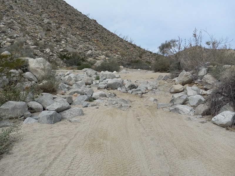
Exactly. It was a nice day and I used the extra time to check out the section of Coyote Canyon road between the gate closure and boulder alley.
My nemesis

Unlucky former resident of Palo Verde Canyon

They weren't kidding about Coyote Creek taking over the road

Boulder alley is back to looking the way it did in 2012
 |
3/18/2024
Topic:
upcoming? Rosa (looking for advice)
Brian
|
Rocko1 wrote:
That ridge is calling my name!
I'd try it again if I had you along for moral support. And if it wasn't super gusty. |
3/28/2024
Topic:
Panamint City
Brian
|
Not Anza Borrego, but I thought this trip report would still fit here.
I did a quick trip to Panamint City (Death Valley National Park) last week. Managed to get a weather window where the bottom of the hike was low 80s and the top was 60s in the day / 40s at night. Just a couple days later on the weekend, the forecast was for lows in the 20s. Glad I wasn't around for that.
This was my first time doing this hike after thinking about it for years. All of the challenges which I anticipated were there but not as bad as I feared. The road to the trailhead did have some spots that were marginal for a Subaru, but I still made it to the end. The parts where you have to walk in the stream and climb wet waterfalls were manageable. There is 3600' of gain, but that was also manageable. There was some minor bushwhacking.
The part I didn't expect - and my least favorite part of the hike - was that the last few miles which I anticipated would be on the former road often ended up in a dry rocky creek bed instead. That made for slow going and foot pain.
This used to be a road until it was washed out in 1983

Some trucks didn't make it out before the road turned into a waterfall

One of the better sections of the dry portion of the hike, after the initial 3 miles of jungly conditions

A couple views of the iconic smelter
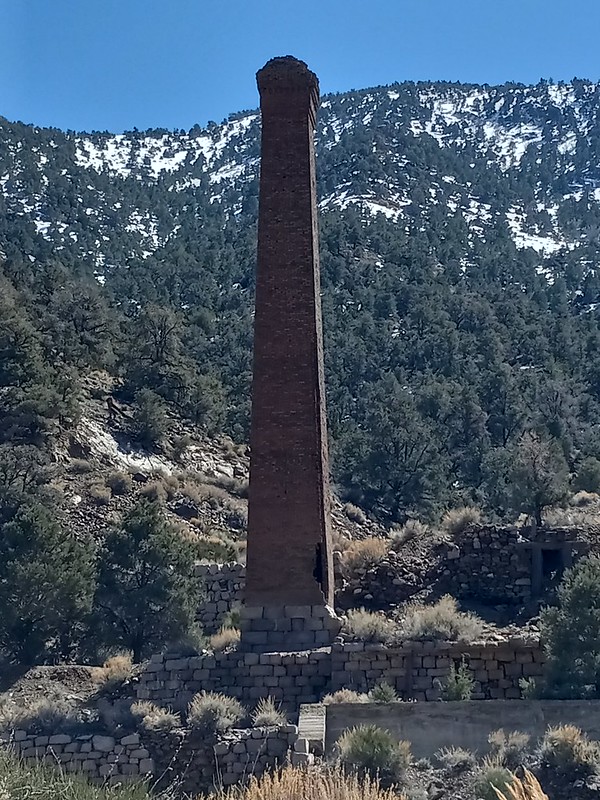

the "Panamint Hilton"

leftover equipment from the mining days


my accommodation for the night and town overview

 |
3/29/2024
Topic:
Middle Ysidro
Brian
|
Nice trip report. I made a half hearted attempt at the western summit last spring but ended up not wanting to deal with the amount of brush on the final approach to the ridge. |
16 days ago
Topic:
Pinyon Wash to Harper Cabin
Brian
|
tekewin wrote:
Those blooms are amazing. Sounds like a successful trip and kudos for being kind to the biker.
Is the road OK all the way to Harper Flat or even Hapaha Flat? I've only been down that road a little ways to hike to Sunset Mountain.
That road ends at a canyon which is a short hike up to Harper Flat. The road that passes Harper Flat on the other side can be accessed 2 ways. One end goes in from Pinyon Mountain Road (which necessitates negotiating the squeeze and heart attack hill). The other end goes in from Fish Creek and passes through Hapaha Flat. The biggest obstacle I know of on that route comes just before you get to Hapaha and looks like this:
It's no longer legal to drive through Harper Flat (despite the fact someone did it last summer and was later found dead).
edited by Brian on 4/12/2024 |
16 days ago
Topic:
Pinyon Wash to Harper Cabin
Brian
|
Britain wrote:
I always thought Harpers was a closed area for vehicles. Park maps show no vehicle trails in it. Weekend warriors.
Older topo maps do show a jeep trail going through Harpers, but it's been closed to vehicles for probably about 30 years. I hiked through there last September and saw the wheel tracks of the guy who drove in over the summer. He went around a fence that's supposed to keep it closed off from the main road. |
16 days ago
Topic:
Pinyon Wash to Harper Cabin
Brian
|
tommy750 wrote:
Was able to find the Tacoma location on GE and the news reports gave info on where the individuals were located.
Wow, the Tacoma was located much further west than I imagined. I had assumed he had driven to a point much closer to Harper Canyon since that is the way he tried to get out. Would have been much easier for him if he had walked down to Pinyon Wash.
The truck hadn't been airlifted out last September when I was there, but I didn't see it. I must have been fairly close. I was taking a friend up that canyon from Pinyon Wash and then over to see the ruins of the cabin. If I had been by myself, I might have explored a bit more and followed the wheel tracks which were still fresh at the time. |
14 days ago
Topic:
Pinyon Wash to Harper Cabin
Brian
|
Britain wrote:
Wasn't there some kid that took his dad's Tahoe stuck in the squeeze and disappeared years ago also?
Yep. I think he actually went in from the other end. From Fish Creek. But the truck was found near the bottom of heart attack hill and one of the tires was completely destroyed, so he wouldn't have been able to make it out that way even if that was a 2 way road (which it isn't). I first found out about that when I was looking at Google Earth to familiarize myself with the area and someone had posted a bunch of pics from the search for the kid. |