2/18/2016
Topic:
Villager Peak trailhead vandalism
tekewin
|
I hate seeing this. Always a concern for me when leaving my car for an all day hike, but thankfully haven't been a victim yet. Some of these remote locations don't see enough traffic to discourage thieves and vandals. Hope it turned out OK insurance wise. |
2/24/2016
Topic:
Palm Mesa High Point and nearby benchmarks
tekewin
|
Hello, Desert forum, this is my first post. I have made many trips to Anza-Borrego and love the desert.
Last Friday, my friend Brad and I hiked up to Palm Mesa High Point from the Los Coyotes reservation. We visited a few benchmarks (Norte, Phil, Cody) along the way. Here are a few photos. The full report is here.


edited by tekewin on 2/25/2016 |
2/25/2016
Topic:
Palm Mesa High Point and nearby benchmarks
tekewin
|
dsefcik wrote:
Looks like a nice area, would have thought there would be some water by now though.....I like the deer...nice TR, thanks for posting and welcome to the forums...
I was expecting water, but the closest I found was a few damp spots. It also surprised me about how little cactus there was compared to San Ysidro and Indianhead. |
2/25/2016
Topic:
Palm Mesa High Point and nearby benchmarks
tekewin
|
Yeah, the morteros were cool and weathered, right on the bank of the canyon. I spotted it on the way back. |
3/10/2016
Topic:
Anza Borrego Wildflower Update
tekewin
|
surfponto wrote:
Last weekend the Barrel Cacti in Indian Valley were looking pretty good.
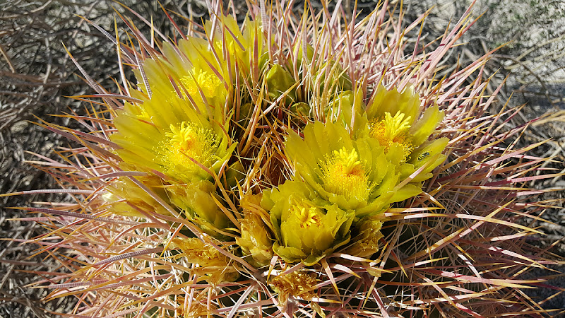
Wow, I've never seen a barrel cactus in bloom like that. And yellow. Great photo! |
3/26/2016
Topic:
Swainson's Hawk migration
tekewin
|
Great story! |
5/11/2016
Topic:
Peak 6582
tekewin
|
A great report and fantastic photos!!
I read about this peak in Jerry's book (I have an older edition) but it wasn't really on my radar. I'm going to add it. I have a thing for rarely visited peaks.
edited by tekewin on 5/11/2016 |
5/11/2016
Topic:
Santa Rosa Mnts / Martinez Canyon 12 Day Backpack
tekewin
|
Nice! |
7/27/2016
Topic:
7 Day Backpack in the Sierras
tekewin
|
Nice trip and photos! |
7/27/2016
Topic:
To the top of El Cajon Mountain aka "The Beast"
tekewin
|
Nice report!
On my first trip to El Cajon, it was August and it was closed. A ranger turned me away. I went back and did the main trail in November that year.
This May, I made my second ascent up the south arete from El Monte road. Definitely more adventurous with a lot of strong class 3. There is a good use trail that fades away about half way up. You won't have any crowds to deal with though if you go that way. South arete full report. |
8/17/2016
Topic:
Looter M.D. Pleads Guilty
tekewin
|
Interesting that law enforcement is taking action based on hiking blog posts. That 20K number sounds high. How much room would it take to store 20K artifacts? |
10/4/2016
Topic:
Mount Whitney
tekewin
|
Congrats! That's a big one to cross off your list. |
10/29/2016
Topic:
Bahia de Los Angeles Road Trip
tekewin
|
Wow, cool trip. Thanks for posting the pix. |
12/18/2016
Topic:
Mt. Tule, Rozzie, Groan and Gasp
tekewin
|
Here are some photos from a loop hike I did last weekend to some remote peaks on the west side of Carrizo Gorge. It is a really beautiful and harsh area. I really love this part of the desert (minus the cholla). The full report is here is you want all the details.
Note: timestamps are off by an hour


 |
12/19/2016
Topic:
Mt. Tule, Rozzie, Groan and Gasp
tekewin
|
ziphius,
Not a single drop of water anywhere. The side canyon we crossed going from Groan to Gasp was dry. Maybe there was some around that palm grove, but we didn't get very close to it. |
1/7/2017
Topic:
Mt. Tule, Rozzie, Groan and Gasp
tekewin
|
Robert,
Sorry for the late reply. I use a Canon Powershot Elph 170IS. Super light, small, and a pretty good point and shoot. It has a 12X optical zoom. It's not prosumer or pro level, but it seems to be the best compromise between quality, price, and portability for me. I usually buy one or two generations old because I go through about one camera a year. I am pretty rough on my equipment. |
1/10/2017
Topic:
Anza-Borrego Desert Region GPX files?
tekewin
|
There are a lot of GPX files for ABSP peaks at peakbagger.com. I upload all of my GPX files there for others to use. |
1/10/2017
Topic:
Anza-Borrego Desert Region GPX files?
tekewin
|
If they are posted on peakbagger, they are intentionally shared. You have permission. For example, if you search for Whale Peak and find the one in CA at 5349', there will be a list of trip reports on the left. Some will have (GPS Track) next the name and that means they uploaded their GPX.
Click on a name with a GPS track and it will show you a map of their track on the right hand side. Below the map is a link to the file (Download this GPS track as a GPX file).
All of mine will be listed under Keith Winston, but many people use different routes, so you might want to browse the different tracks to select the ones you want to use. Good luck with your app! |
2/9/2017
Topic:
Hayfield Springs and the Joy of Discovery
tekewin
|
Really cool bighorn find! Looks fresh. I would have been looking around for big cats, too. I'm glad you found a petroglyph for your efforts. Thanks for sharing your photos.
edited by tekewin on 2/9/2017 |
2/22/2017
Topic:
Badlands from Mine Peak
tekewin
|
I hiked to Mine Peak off West Dolomite Mine Trail for a few sunrise photos of the badlands. I made a day of it hiking to Red Hill and Jacumba Mountain after, but these were the best views of the day.


 |
2/23/2017
Topic:
Mortero Palms and Piedras Grandes
tekewin
|
Great shots! I recently noticed the furry green ocotillo, too. Blooms should be on the way soon. |
2/27/2017
Topic:
Badlands from Mine Peak
tekewin
|
I thought I'd add this photo of an interesting rock pile in the flat area above Mortero Palms on the way to Jacumba. There were some obvious natural caves in the formation that I wanted to explore but ran out of juice on the way back. The rock pile is clear on the topo, but doesn't have any name or elevation info associated with it. By any chance, has anyone checked this pile out?
 |
2/27/2017
Topic:
Bow Willow to the Linehouse in Rockhouse Canyon
tekewin
|
Very nice! I haven't been in that area yet. More reasons to go. |
3/6/2017
Topic:
Strange things you find in the desert.
tekewin
|
Gotta admire the craftsmanship. |
3/8/2017
Topic:
Best places for viewing?
tekewin
|
Anza-Borrego made national news for the superbloom.
https://www.washingtonpost.com/news/capital-weather-gang/wp/2017/03/08/this-park-in-the-desert-southwest-is-experiencing-a-wildflower-superbloom/
What areas do you guys/gals think are the best viewing spots? |
3/9/2017
Topic:
Best places for viewing?
tekewin
|
dsefcik wrote:
Henderson Cyn is always spectacular but crowded....anywhere that has big open sandy washes will be blooming.
Thanks! |
3/11/2017
Topic:
Best places for viewing?
tekewin
|
Nice! |
3/21/2017
Topic:
Anza Borrego Super Bloom crowds
tekewin
|
Crazy number of people. I am sure the multiple newspaper articles got more than a few people out. |
3/21/2017
Topic:
Best places for viewing?
tekewin
|
Awesome photos! I could not drag the family out the last couple of weekends. I will be bummed if I miss this year. |
3/29/2017
Topic:
Red Tail and Kestrel going at it.
tekewin
|
Awesome birds! Awesome snake! Those are some high quality shots. Impressed. |
4/20/2017
Topic:
Ranger Steve dies in shooting incident
tekewin
|
I can't believe there are still no details on this. I don't know why the story would not be released, but it is somewhat unsettling. RIP ranger Steve.
edited by tekewin on 4/20/2017 |
4/23/2017
Topic:
Ranger Steve dies in shooting incident
tekewin
|
Borregolinda wrote:
What story? What details do you want? Unfortunately he ended his life in his desert. Not sure what other details are needed to be released.
Oh, I didn't automatically go there. I read it as either an accident or someone shot him. I didn't mean to disparage him or this tragedy. |
4/27/2017
Topic:
Ole Red... well a younger one
tekewin
|
Beautiful snake! Thanks for saving him. |
5/2/2017
Topic:
Ole Red... well a younger one
tekewin
|
I see I am not the only one that uses poles that way. I like to give the ground extra vibrations so snakes know I'm coming and also to poke into areas I can't see before I step there, especially high grass or brush. |
5/10/2017
Topic:
Your Go To AB Book?
tekewin
|
Ben Baumans site has good trip reports for all of the Sierra Club San Diego Peaks.
http://silverset.net/100-peaks-in-san-diego
I am working on that list and have 72/100 but a lot of tough ones left. Also, another plug for Jerry Shad book. That was the first place I read about Goat Canyon Trestle. |
5/22/2017
Topic:
Another Desert Iguana...last one of the season.
tekewin
|
Your photos are incredible. I appreciate everyone who lugs around an SLR and gets superior results like this. As much as I'd love to take these kinds of shots, I can't get myself to spend the money or carry the extra weight. |
5/28/2017
Topic:
Coyote Mountain crazy wind
tekewin
|
I drove down to Borrego Springs Friday morning to hike Coyote Mountain from the normal southeast ridge route. It started out calmly until I hit the second bump when the wind blasted me head on. My guess is it was a steady 30mph, but gusts to 60mph+. I've never experienced wind like that. Hard to move and it knocked me down once. I thought about turning back, but decided to tough it out. The wind didn't stop all the up, though I got some relief below the larger bumps on the ridge. I had a friend driven out of the Mojave for a couple of days in March by strong winds, and I guess I got a small of taste of it. Really awesome views on the way up and from the top. Guess I better start checking the wind forecast. 
https://www.youtube.com/watch?v=Dlp8dJnI3r4


edited by tekewin on 5/28/2017 |
5/29/2017
Topic:
Coyote Mountain crazy wind
tekewin
|
What a huge bloom just a couple of months ago! I'll check the NOAA site to see if I can figure out the wind forecast. I wonder if Coyote gets stronger wind due to its isolation between higher mountain ranges and wide valleys. I spent some time Friday afternoon off trail around upper Hellhole Canyon and the wind was no more than a breeze. |
5/29/2017
Topic:
Coyote Mountain crazy wind
tekewin
|
Rockhopper, I think it would have been a different outcome if sand and cactus were airborne. I always ignored those high wind warning signs, until now. |
6/17/2017
Topic:
Rumorosa Baja
tekewin
|
There are many beautiful places in Mexico, but I don't really feel safe heading down there, even though I have friends that go there all the time. |
6/17/2017
Topic:
Big Boy between hwy 8
tekewin
|
Another sweet photo! |
7/18/2017
Topic:
Photo hosting recommendations
tekewin
|
Google Photos is pretty good and free. You can create and share albums as well as individual pics. Convenient if you are already in the Google universe. Here is an example album.
BTW, I had the same issue with photobucket. It took me three weeks to download all my photos from photobucket and upload them again to Google Photos.
edited by tekewin on 10/7/2017 |
8/6/2017
Topic:
The Island
tekewin
|
Cool find and obscure! Looks like a Paul Freiman placed register. I'll make a note of this one, but I have a year or two of SD peaks already queued up. Thanks. |
9/10/2017
Topic:
Goat Benchmark
tekewin
|
I wasn't sure whether to post this under trip reports or here, but this is pretty hard to reach. Goat Benchmark is #45 on the Sierra Club San Diego Peak List. It is a small bump near the head of Hellhole Canyon and nearly invisible until you are right on top it. There are many small boulder piles in the area and picking it out without a GPS would take superior map skills. I used a GPS to find it, leaving from S22 and circling around to it from the north past the Thimble. I made a direct attempt in May from Culp Valley but ran out of time before reaching it that way. In one of the side canyons, I found deer parts and what looked like a juvenile deer head, still with some wet brain matter inside. Insects hadn't had enough time to clean it up completely.

Starting at sunrise

Goat is a small bump out there somewhere

Descending
Passing by The Thimble


Juvenile deer I think
As far as other wildlife, I startled a couple of adult mule deer, but they were too fast for me to get any photos. Jackrabbits and birds were in abundance. Bighorn scat was everywhere, but I didn't see any. It seemed like a long time before I finally laid eyes on Goat. Once found, the summit was an easy boulder. A higher mound stands just behind it. The register went back to 2001 and was quite thin. I was the fifth party to visit Goat in 2017. It doesn't see much activity. Unless you are chasing the San Diego list, there is no reason to go there. If you end up there by accident, you are probably in serious trouble. I don't know why the US Army Corps of Engineers decided to mark it, but I really appreciated the remoteness. It had great views, being sort of Hellhole Central.


Benchmark and register cans


Looking down Hellhole Canyon

Here it is circled from my trip in May, the direct route is pretty tough

On my way back, I climbed Clyde and Hut BM, I had done Bonny on a previous trip

edited by tekewin on 9/10/2017 |
9/10/2017
Topic:
The Island - PAH BM
tekewin
|
This was an awesome report and PAH is going on my list! Way to stick with the research.
Darren, if you wouldn't mind, could you email Terry Flood through Peakbagger with the correct coordinates of PAH so he can fix the entry? He was the one who added it to the Peakbagger and I'm sure he would be happy to fix it. That's probably faster than contacting Greg Slayden who runs Peakbagger. I (and a lot of people) rely on accurate data there and you could save someone else the wild goose chase. |
10/7/2017
Topic:
Goat Benchmark
tekewin
|
rocko1: 9.4 miles round trip, 2600' gain, took me 6 hours 10 minutes. I love this area, but it always seems more difficult than I expect.
ziphius: You are probably right about the scat. I saw several adult deer in the area and some deer bones. Please post your photos if you head out that way. |
11/3/2017
Topic:
Red Hill
tekewin
|
That's a fun hill with red volcanic rocks. What a zoom you must have on your camera. I went back and looked at my photos from the summit and McCain was a fuzzy ridge. Definitely peanut butter and jealous of that camera set up. Thanks for posting. |
11/30/2017
Topic:
Rockhouse, Jacumba Jim, Four Frogs and East Fork
tekewin
|
Awesome trip! What a find that owl is. |
12/13/2017
Topic:
A trip started in the desert
tekewin
|
Awesome!! |
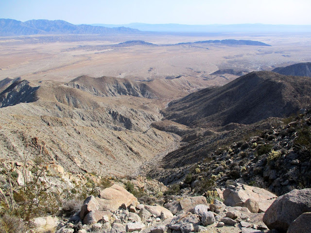
12/19/2017
Topic:
Split Mountain East and West
tekewin
|
Split Mountain is about 10 miles south of Ocotillo Wells. The trailhead for Split East starts about 4 miles down Fish Creek Wash by the wind caves. I engaged the 4x4 for the last mile or so because of rocks and sand. I followed the trail to the wind caves, then continued up on a faint use trail that I lost and found a few times. From the top of a ridge, I realized there was no connecting ridge to Split Mountain East and that I needed to cross one of the dried mud washes. On the other side of the wash, I got my first look at the summit and it was a clear ridge walk from there. The register went back to 1994. I descended more directly back to the truck dropping in and climbing out of the major gully as needed. The round trip to East was 4.1 miles, 1700' net gain, and took 3 hours 15 minutes.

Wind caves


Elephant Knees formation and badlands

Crossing the mud wash

Summit
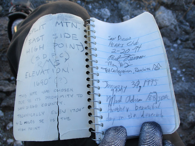
Split East register
The trailhead for Split Mountain West is only a half mile from the East trailhead, but the road is even rougher with big rocks. I started up Oyster Shell Wash, then took a right into a more direct wash. There were a few class 2 scrambling sections, boulders of all sizes, mud pits and mud slabs. Steep walls rose up on both sides. The topo map is not as useful here where smooth 40' contour lines hide 30' cliffs. This is tough terrain to navigate with all the broken ridges and washes. I followed the wash a little more than a mile before I reached a three way fork. I continued straight up and over a small rise to drop into another wash with high, pock marked walls on the right. I hugged the wall until I reached another fork. This time, I went left and climbed steeply out. At a local high point on a ridge, I saw the double peaked summit about a half mile away. There is some controversy over the true summit of Split Mountain West (the official Sierra Club summit). Peakbagger has it marked on a ridge about 0.4 miles southeast of the actual summit. The left peak of the double peak is slightly higher, as measured with a surveyor tool by Wes Shelberg in 1993. At the Split West summit, I found the double red cans that typically hold Sierra Club registers and signed in. Many of the people on peakbagger apparently stopped at the other ridge because their GPS tracks ended at that spot and their names were not in the register. I sent an email to Greg Slayden who runs the site with evidence of the correct location but I'm not sure if it will be updated (or it anyone really cares). Split West doesn't get much traffic. On the way down, I tried to descend the wash from a higher point than where I left it. It didn't work out quite as I expected and I ended up going down a feeder wash that required trickier down climbing to get back on my ascent route. That just hammered home the potential navigation issues. It's easy to take a wrong turn and get cliffed out. I think the scenery on Split West was even more impressive than Split East. I scored two mylar balloons on the way out. The round trip to Split West was 5.4 miles, 1900' net gain, and took 3 hours 35 minutes. I love this area and would love to come back and explore farther down Fish Creek Wash. It's quite a long drive from the OC, though.

Dropping into the ascent wash

Scramble section (would be a mudfest if wet)

Looking back after climbing out


Explanation of the placement at this location as the high point


Descending
edited by tekewin on 12/19/2017
edited by tekewin on 12/19/2017 |
12/20/2017
Topic:
Windy BM
tekewin
|
Did you follow the tracks from Dos Cabezas? I've been in the area a couple of times but never made it to Windy. |
12/20/2017
Topic:
Split Mountain East and West
tekewin
|
Weather was perfect, low of 50 and warmed up to 70. |
12/20/2017
Topic:
Split Mountain East and West
tekewin
|
dsefcik wrote:
Love that area, thanks for sharing. You can definitely get cliffed out easy in the Fish Creek Mtns. Hope to get out there this xmas break.
Yeah, the landscape is so broken, it was tricky. Such cool geology. |
1/7/2018
Topic:
Carrizo Creek, BM LOST and South Mesa
tekewin
|
This was a cool trip. The area around Lost BM looks very interesting. I scanned caltopo around Bow Willow Creek but didn't see Lost on the map. I might have been looking in the wrong place. I noticed the benchmark was placed by the Division of Beaches and Parks. I just saw one of the those marks on top of Sombrero. I guess all of Anza-Borrego is a state park, it's just odd to find those markers in the remote desert. |
1/7/2018
Topic:
Sombrero and False Sombrero
tekewin
|
I had a great day in the desert bagging a couple more peaks from Indian Valley. The first was Sombrero and there are already several reports on this route so I'll keep it brief. At the top, I found two boulders that were candidates for the high point. The first one (and probably highest by inches) was a class 1 walk up. The other was somewhat difficult. The easiest way I found to get up was to climb a 12' crack using hand jams. Other routes were class 5. On top of the second boulder, I found a benchmark from the Division of Beaches and Parks. I don't think many people find it and it isn't mentioned in most trip reports. 3.5 miles round trip, 2000' gain, 3 hours.

Sombrero and False Sombrero from the road fork

Easiest way up (I think this boulder is probably second highest)

Sombrero benchmark on the second summit block

Found this weird pole and chain on the way down, a few hundred feet below the summit
Next, I drove to the end of the North Indian Canyon Road to tackle False Sombrero. The hike had two parts. The first part was climbing up a rough gully and the second part was a steep sandy slope. The sand was 3" deep and it was like walking on the beach at a 35 degree angle. It was only a mile to the summit, but the route gained 1359' in that one mile. Stiff. The summit block was easy and the register there went back to 1989 and was only a little over half full. I recognized almost half the names. The views were even better than from Sombrero, especially of the Sawtooth Mountains and the Inner Pasture. I hung around the summit for 20-30 minutes, an eternity for me, resting and enjoying the sights and perfect weather. I couldn't help but think of the poor souls in most of the country dealing with sub-freezing and sub-zero temps.

North gully and False Sombrero

Looking down the sandy slope, Sombrero in the background

Indian Valley from False Sombrero

Laguna Mountains, Inner Pasture, Sawtooth and Red Top

Some day!

Hey, I know that name. Via Canebrake!? How does that work? Oh, cliff bar is long gone.
I looked at the topo and could not figure out how to get there from Canebrake without a long approach. Returning was much easier as I casually plunge stepped the sandy slope and scrambled back down the gully. I know I'll be heading back to Indian Valley, but maybe not until next year. 2 miles round trip, 1359' gain, 2.5 hours.
edited by tekewin on 1/7/2018
edited by tekewin on 1/7/2018 |
1/8/2018
Topic:
Carrizo Creek, BM LOST and South Mesa
tekewin
|
tommy750 wrote:
BM Lost is about 1.2 miles north of where Canyon Sin Nombre dumps into Carrizo Creek. Easy hike and nice views. The only other named BMs I know of out in that area are Pelvis, Valle, Leckie and Gert.
https://www.ngs.noaa.gov/CORS-Proxy/NGSDataExplorer/ is a good source of info on BMs and I use it all the time
Thanks! Saved for later. |
1/9/2018
Topic:
Sombrero and False Sombrero
tekewin
|
RobMay wrote:
Thank you for posting. I've still got to bag both of these peaks. I hit Red Top and Sawtooth Mountains HP this past weekend. I didn't realize the steepness or the amount of boulder scrambling that was involved. I got my butt kicked and hiked out in the dark. I've been following your blog online and your gps tracks on Peakbagger for some time now. Thank you for all of your hard work! I still haven't figured out how to make the time to blog about hikes I've been on. I feel accomplished if I get photos posted to Facebook for the week. Anyway, I just wanted you to know that you rock!
Hey Rob,
Thanks for the kind words. I've gotten so much from other people reports, the least I can do is share what I find. I enjoy writing reports as soon as I can so I don't forget details.
So, how did you approach Red Top? I was planning to start from North Indian Canyon Road (as Daren's suggested) and go over the lowest pass in the Terra Blanca, then up the gully between Red Top and the Sawtooth high point. I think it will be the toughest hike on the San Diego Peaks list and I want to save it for last. |
1/10/2018
Topic:
Sombrero and False Sombrero
tekewin
|
ziphius wrote:
Crack climbing without a crash mat? 😊 I did Red Top a few years ago (2012), starting at Agua Caliente, through Moonlight Canyon, camped in Inner Pasture, then ascended Red Top early via the WNW slope in the shade. My mistake was spending too much time bushwhacking in the drainage that approaches Red Top from the south end of Inner Pasture.
The crack was only 12-13' with no exposure below, but I did have an adrenaline buzz for a while after. Thanks for the tips on Red Top. Maybe I'll stick to ridge lines. |
1/10/2018
Topic:
Sombrero and False Sombrero
tekewin
|
dsefcik wrote:
We did a loop hike once from Indian Valley up and over False, down into Canebrake and then circled back out via the low saddle just east of False.
I lost my GPS going down into Canebrake so on a different trip I did the reverse of that loop looking for it. We have done many variations of that coming in from McCain.
Thanks for links to your trips. I did a forum search for "false sombrero" and didn't find them before. Now I see the loop you did from the first trip. Tough way to get into the Inner Pasture. Amazing photos. The combs were long gone, too.
dsefcik wrote:
I have seen that chain at Sombrero before, no idea what it is for. Is the register still missing? It used to be an ammo box chained to the top boulders but went missing several years ago.
Great trip report, thanks for sharing
I could not find a register on Sombrero. I climbed the second boulder partly to see if the register was up there. No register, but the benchmark was a bonus. I look forward to finding your name in more SD registers  |
1/10/2018
Topic:
Sombrero and False Sombrero
tekewin
|
RobMay wrote:
I used Greg Gerlach and Patrick ONeill's gps tracks. I like to load multiple tracks so I have options. It's the same route you describe. I camped on the small ridgeline due North of the lowest pass you cross over. The plan was to hike Stage BM the next morning but that didn't happen. I hiked Villager/Rabbit/Mile High four days prior and I wasn't fully recovered from that hike. I found a lot of pottery shards so I spent way too much time exploring, and I deviated from the gps tracks going up Sawtooth and summited from the South-West side of the peak. Huge mistake. I was thinking about leaving Groan as my last just because I feel like the name is an apt one to finish on!
OK, cool. Names like Groan are great! The pain benchmarks, ha. Groan, Gasp, Moan, Puff, Grunt. |
1/12/2018
Topic:
Sombrero and False Sombrero
tekewin
|
Buford wrote:
I too thought the view from the “other” Sombrero was much better.
There was a register on the real Sombrero in February 2017. We had a hard time finding it. It was near the slightly lower summit block, not the one with the crack climb.
edited by Buford on 1/11/2018
Yeah, love the views from False. |
1/12/2018
Topic:
Borrego Rainbow
tekewin
|
Wow, perfect shot! |
1/15/2018
Topic:
Carrizo Gorge East Side
tekewin
|
Looks like an interesting trip. A lot of history in some of those photos. What is that animal skeleton? Some kind of rodent? |
2/4/2018
Topic:
Gert BM
tekewin
|
Sweet. Are those mud hills solid or can they collapse into caves? |
2/4/2018
Topic:
Hiking out of Los Coyotes Indian Reservation
tekewin
|
I've hiked to Cody, Norte, Pike, Palm Mesa HP, and Square Top from there. Different 4x4 parking spots. Every time I've gone, usually early in the morning, but once late morning, there was nobody at the guard station. I think there is day hike fee, so I left money taped to the door in an envelope. I've read conflicting things about restrictions and maybe they have changed policies. I'd go early, be honest if stopped at the guard station, but otherwise go about your business. |
2/4/2018
Topic:
Gert BM
tekewin
|
Wow, that looks pretty chancy. Very adventurous! |
2/9/2018
Topic:
Carrizo Badlands
tekewin
|
Those photos, wow! Love the badlands. |
2/10/2018
Topic:
Pyramid-Villager Loop
tekewin
|
The weather was favorable for a partial traverse of the Santa Rosa range crossing five peaks, four of them on the Sierra Club San Diego Peaks list. The plan was to start at the Villager trailhead, ascend Smoke Tree Canyon to the major ridge, then hit five peaks in this order:
Pyramid Peak (SDC #62)
Marble Peak (Unofficial)
Rosa Point (SDC #28, DPS #67, HPS #281)
Mile High Mountain (SDC #24)
Villager Peak (SDC #12, HPS #208)
I started and finished in the dark. I decided to back load the night hiking, figuring it would be easier to follow the VIllager trail down than ascend a canyon. I started at 5:45 AM, covering the mile or so up Palo Verde Canyon to the Smoke Tree Canyon split before sunrise. I made a short side trip to the Natural Rock Tanks. Despite the lack of rain, there was water in the first tank I visited. On Pyramid Peak, I had great views to Travelers Peak and Salton Sea. Next was the long 1700' climb to Rosa Point, one of the toughest sections of the day. I hunted around the long flat summit until I found the benchmark. It was about 100' southeast of the summit rocks in an open, flat area.


Natural Rock Tank with water

Travelers and Salton Sea

Looking back from Rosa Point
After a few false summits, I spotted Mile High Mountain. The terrain above 5000' started to change. Pines and junipers grew along with other shrubs missing from the lower desert slopes. The hardest part of the day was the 1000’ drop off Mile High then up an alluvial fan to the Villager Ridge. Mostly class 2 and 3. From there, I was only one mile and 500’ gain from Villager. The views into Clark Valley were stunning. I can see why Villager is so popular. I didn’t stay long because I only had an hour of daylight left.
At sunset, I stopped to unpack lights (headlamp and flashlight) and take inventory. I was behind schedule, a mile in the air and 5 miles from the truck. Worse, I was dehydrated and down to 8 oz. of water. Despite drinking two bottles of water on the drive to the trailhead, I hadn't brought enough. None of the bars or food I had left was appealing, but I forced myself to eat something to power the descent. Thankfully, the trail remained clear and well defined. My knees, hips, and lower back all complained from accumulated minor insults. I thought I would be back at the car by 7:00 PM. When that time came, I was still 3 miles out, watching tiny headlights below dance along the S22. I had cell service so I texted my wife to let her know I was OK. When I reached the truck, I sat down to guzzle two bottles of water before starting the drive home. 19.2 miles, 7107’ gain, 14 hours 45 minutes. More gory details here.

Villager from Mile High

Mile High from the saddle

Villager summit


edited by tekewin on 2/10/2018 |
2/11/2018
Topic:
Pyramid-Villager Loop
tekewin
|
Darren: I can only muster one or two attempts like this a year. I think it's been three years since I completed one this big.
rockhopper: Not quite the stats of Rabbit. I did need more water, but it's always a black art to figure out the trade off between extra weight, speed, and how much you need. I usually carry too much. Couldn't cache any because it was a loop. I planned to spend hours in the dark, so that wasn't a problem (as long I didn't see green eyeshine following me!).
Britain: Thanks! It pushed me in several ways.
No mylar balloons to my surprise, but I did collect a white running hat while climbing up to the Villager ridge from Mile High. Also found some kind of trashy romance paperback on a rock about a half mile from the road on the way back. I didn't touch it.
edited by tekewin on 2/11/2018
edited by tekewin on 2/11/2018 |
2/11/2018
Topic:
Pyramid-Villager Loop
tekewin
|
ziphius wrote:
Nice trip! Amazing that there is still some water at Natural Rock Tanks. How much water did you actually carry with you? Read your blog too... my favorite electrolyte drink is 9/10 water + 1/10 orange juice + dash of table salt. The acidity of the O.J. is no problem because it is so dilute and it doesn't go bad in warm weather either. Again, impressive trip. - Jim
JIm: I carried 212 oz (6.2 liters / 13.25 pounds). That was combined water, propel water, and G2 gatorade. I also had a couple of salt pills (sodium/ potassium). Not sure if electrolytes were a bigger problem than lack of water. Never heard of that OJ trick, will keep it in mind. I've been in spots like that before and figured I could ration it, even though it was unpleasant. I envy ultra runners that get by with half the water I need. |
2/12/2018
Topic:
Pyramid-Villager Loop
tekewin
|
Rockhopper: I'm with you about awesome peaks of the Southern Santa Rosas. One I won't forget.
Buford: Thanks. Good luck with the loop to Mile High. Do you think you'll come down Villager Ridge from Mile High or down Rattlesnake Canyon? |
2/12/2018
Topic:
Pyramid-Villager Loop
tekewin
|
Buford wrote:
If I do the loop, the decision between heading down Rattlesnake or the Villager ridge will depend on what I see when I get there. I saw a report somewhere that Rattlesnake Canyon is passable all the eay down with a couple dry falls to contend with.
I think I saw your blog in the Goat BM register recently and just made the connection with the post here.
Bob Burd descended Rattlesnake Canyon, hit a few class 3 falls on the way down, but it didn't look too bad. Yeah, I did Goat last year in September. I felt really isolated out there, in a good way. Found a baby deer skull in one of the gullys. |
2/14/2018
Topic:
Jacumba Jims and Jim McCains shack
tekewin
|
South side of Jacumba Mountain? That's a lot of water. Need to study the maps more around that area. Awesome photos as usual. |
2/15/2018
Topic:
Gasp and Grunt BM's
tekewin
|
I did Gasp in Tule-Groan-Gasp loop, but not from the gorge.
Grunt BM is on my list. I was going to follow this GPS track staying on the north track in the wash as long as possible both up and down. There was a register there with only a few entries according to the last report.
http://peakbagger.com/climber/ascent.aspx?aid=619070 |
2/17/2018
Topic:
Gasp and Grunt BM's
tekewin
|
Britain: You planned out a nice loop route. My friend Eric Su descended the ridge between Gasp and Grunt and came back up on your route. The ridge up to Gasp from Grunt is about 1500'. The only comment he made about Grunt itself was that the cholla was thicker than around Groan/Gasp. Looking forward to your trip report |
2/19/2018
Topic:
Pyramid-Villager Loop
tekewin
|
Buford wrote:
Tekewin’s post got me motivated enough to do the loop today. Thanks for posting the route!
Started at 6:45 am, a little later than planned.
Bagged Pyramid at 8:30 after a straight forward climb.
I was surprised at how good the use trail was going to Rosa.
Made it to Rosa Point about 10. The final stretch was rough.
Summited Mile High at noon.
Dropped down to the saddle at the top of Rattlesnake Canyon. Decided to hit the Villager ridge line for the superior views.
Climbed the Villager ridge line and topped out at 1:00.
Realized I was ahead of schedule and had plenty of food and water and could hit Villager again since it was only 1k of gain and a mile away, but then realized I was ahead of schedule and could get to Dudley’s before closing. Immediately went downhill and out.
Back At the car at 3:00, Dudley’s about 4:15.
No sheep on the hike, but plenty of signs of them. I did see a ram cross Montezuma grade this morning about 6:00 am.
Tons of roasting pits along the route.
There was an icy wind up high. I had to find a sheltered spot on each summit to sign the register and eat a snack. A couple gusts were strong enough to affect my footing. The cold wind helped cut down on water needs.
Edit, can’t get pictures to show up from mobile. I’ll add a few later.
edited by Buford on 2/18/2018
edited by Buford on 2/18/2018
Wow, you made awesome time. Well done! |
2/22/2018
Topic:
Pyramid-Villager Loop
tekewin
|
rockhopper: I recognize the view to Mile High, but where is that boulder in relation to the Villager summit? |
2/25/2018
Topic:
Grunt BM
tekewin
|
Looks fun! Less cholla than I thought would be there. Did you find a register? |
2/25/2018
Topic:
Grunt BM
tekewin
|
Thanks for the register shot. I was wondering if it was still there since other people reported seeing it. 30 minutes for a mylar? That's dedication. |
3/3/2018
Topic:
Never too old
tekewin
|
So awesome to be active and engaged at 70. Best of luck! |
3/6/2018
Topic:
Gasp from The Gorge
tekewin
|
So close! Did you start at the same place in the gorge that you used to get Grunt?
Hard to believe you found water anywhere out there. |
3/17/2018
Topic:
Gasp from The Gorge
tekewin
|
That's an awesome photo of Grunt, so much detail! I hope I can make the trip out to Grunt this year.
edited by tekewin on 3/17/2018 |
3/29/2018
Topic:
Canyon west of Moan
tekewin
|
East or west of the tracks? A wild area for sure. I don't recognize anything. Nice photos as unusual. |
3/31/2018
Topic:
Canyon west of Moan
tekewin
|
Cool, thanks for the info. |
4/4/2018
Topic:
Yuha basin petrified wood
tekewin
|
Sweet! I keep learning about new stuff on this forum. |
4/10/2018
Topic:
The Potrero Day Hike
tekewin
|
Double rattlesnakes! And a scorpion bonus. What a great day. I still have about zero knowledge of native american artifacts, so the shelter with prayer sticks wouldn't have even registered as anything but natural to me. I wonder how many things I've walked by and didn't appreciate. Thanks for the great report. |
4/15/2018
Topic:
Sunset Mountain
tekewin
|
I drove up Pinyon Wash to get as close as I could to the west side of Sunset mountain. From my parking spot, I walked a half mile across the flat desert toward the western slopes. The thorny population consisted mostly of cholla, agave, ocotillo, and barrel cactus, in that order of frequency. After ascending the main wash a short distance, I started up a slope on the left. The angles were steep and the non-boulder sections were decomposed granite. The chossy crust on the dirt often gave way. Class 2 boulder sections came up now and then and were a welcome oasis of stability. Route finding was mentally taxing. In addition to avoiding the cactus and agave, almost every step required careful attention. It was slow, steady progress kept manageable by the short distance.


I hit the edge of the northwest ridge and was greeted with awesome views into Lower Borrego Valley. A short time later, I was on the summit. The benchmark and register were about 25' from the highest boulder. The benchmark was stamped "Yak". On top, wind blew steadily with gusts in the 25mph range. There were several books in the register cans and I signed the latest one before packing up and heading down out of the wind. When the wind was still, nothing moved and nothing made a sound. I'm used to being alone on remote desert peaks and the silence was notable, almost unnatural. I was glad to get down without a fall. 4 miles round trip, 2000' gain, 4 hours.

Lower Borrego Valley and the Borrego Mountains below


Looking south over the Vallecito Mountains

Descending back to Pinyon Wash |
4/18/2018
Topic:
Sunset Mountain
tekewin
|
Views exceeded expectations, but so did difficulty of the west slope. Beautiful mountain, and thankfully the route was not any longer. |
4/19/2018
Topic:
Sunset Mountain
tekewin
|
rockhopper wrote:
Nice day hike with fantastic views. Thanks for sharing. I hope you were using hiking poles going down!
Yes, I almost always use one pole. An exception would be a hike that's all trail, but that doesn't happen very often. Knees were still sore for a while after the descent. |
4/20/2018
Topic:
Sunset Mountain
tekewin
|
Britain wrote:
When I was coming down from my failed attempt of Gasp, I was in a steep downward hill. I had a 2 foot drop so I dropped my pole down to steady myself so I could leap down. The hill under my pole gave way and I flipped over and skidded down on my pack for about 10 ft. Ended up in a comfortable position and did a prayer that it didn't break anything. Wonder if theres any other opps on trek poles out there.
Ouch. Glad that ended OK. |
4/23/2018
Topic:
No Big Horn this year seen during hiking
tekewin
|
So far, seven trips to the desert this year, zero bighorn spotted. |
4/30/2018
Topic:
To the top of El Cajon Mountain aka "The Beast"
tekewin
|
100 tough summits! Great achievement. |
5/9/2018
Topic:
McCain Valley
tekewin
|
Great trip! Had no idea there were packrats in the desert. I sometimes find woodrat nests in the Santa Ana Mountains, 90% sticks and twigs.
What an impressive snake. Reds are my favorite rattlesnakes. I've only seen one rattlesnake this year (speckled), in the San Mateo Wilderness. Never seen one in Anza-Borrego. I'm not complaining, it probably means I'm making enough vibrations with my heavy steps and pole to shoo them away. |
5/17/2018
Topic:
Santa Rosas Prospectors Rock House
tekewin
|
Excellent sleuthing. |
5/30/2018
Topic:
No Big Horn this year seen during hiking
tekewin
|
Dang. I did two hikes in the area this year and nada. Come to think of it, the only place I've seen bighorns in AB was on a ridge on the way to San Ysidro East. Scat and prints are everywhere, but they are hard for me to spot. |
5/30/2018
Topic:
RHC 4 Day Backpack
tekewin
|
Awesome trip as usual. Looks like a gopher snake in the water.
I know there are lions in the desert, but surprised they find enough food. There aren't that many bighorns and I thought deer were in higher forested areas. I've read there are hundreds of lions in the Palomar and Agua Tibia areas. OTOH, they can roam hundreds of miles.
Is that a 22 or an air rifle? Can't tell from the photo. I am shocked that there are grow farms in RHC. They are all over the San Gabriels but this is news to me. Thanks for posting! |
6/13/2018
Topic:
Canyon Sin Nombre
tekewin
|
Excellent video! This area does look nice. Thanks for posting. |
6/24/2018
Topic:
Not enough rangers
tekewin
|
Wow. This is shocking. I'd rather have a full staff at all the parks than a half built high speed rail system, but that's just me. |
7/3/2018
Topic:
2018 BHS Count Results
tekewin
|
Impressive. Is the count up or down from last year?
I had a hard time seeing the sheep in a couple of those zoomed photos. Man are they hard to spot sometimes.
I would be interested in this next year if I am in town. |
9/11/2018
Topic:
Carrizo Gorge update
tekewin
|
Great update. Appreciated. Closing those gates won't stop anyone except maybe on dirt bikes.
Can the Sheriff really spare officers to patrol the rail line? To patrol the whole line would be an all day affair. I think it is more likely they would send private security or their own employees if they really wanted to patrol it, but who knows. I never follow the tracks in that area. |