10/24/2012
Topic:
End of Dos Cabezas Road
waning moon
|
Well third attempt to post
Anutum,
If I may suggest, look into a set of air bags for your rear axle, your truck has very stiff suspension as is, but your overloads do not engage until you are already tilting, air bags will stop this. You can order online and install yourself as I did or have them installed. I usually put in 35 to 40 pounds (camper on) with an air chuck, they also have an auto system with a pump, costs more though. I installed on my Ford 7.3 Turbo 12 years ago, never regretted it.
On swaying when camped, I will drop two of my camper struts if it is bad enough where I cannot sleep, I see you have auto struts, lucky you, I went for cheaper version "hand cranks"
Your photos are wonderfull, looks like you made it to tunnel 11
Hope this helps |
10/25/2012
Topic:
End of Dos Cabezas Road
waning moon
|
Please I am sure I was not doing things correctly, you site is very interesting as evidenced by my persistence. Especially enjoy the photos and reports on places I have not been in a very long time, want to go back.
Thank you for your welcome |
12/12/2012
Topic:
Yuha Day Trip
waning moon
|
Yuha Basin / Bluffs brings back so many memories, it has always been mystical / magical, at least to me. First went there in early sixties when I was young, hiked most of the basin, the well (had water in the casings then), concretion and mud hills, pebble terraces with agate, quartz, jasper, petrified wood and palm, and of course the shell beds. Walking the bluffs there were 5 to 6 foot cleared circles, desert varnish heavy on the repositioned rocks, been that way for at least centuries, cannot remember if the geoglyphs were even known or fenced, but do not remember a fence. Melting old adobes were at the turn off road from highway into Yuha, by Coyote wash a few wattle and daub adobes also slowly melting.
Picked up a wrecked Datsun 1200 fastback in 1970, bought a wrecked counterpart (rear end damage) and welded them together, a couple of lift shackles and it was off road, all of Yuha was open, air out of the tires, R's kept up to 3k or over and went everywhere, never got stuck (what a lucky stupid kid I was) In the early 70's it was one of the off road places to be, very crowded on weekends, Yuha even served as a short course off road race track, I was there on the first Honda three wheeler and the place was being ruined, I stayed on the roads and would almost fall off and wreck a couple of times because I was looking at rocks and or plants, look there is desert holley, 'crash" look arrow weed, petrified wood, crash crash crash, I was not that good on a three wheeler.
It was easy to get lost in Yuha even after having been there a hundred times, but you could climb a bluff and always see the bunker, get your bearings, Bunker has been gone for a long time. My kids learned how to ride (on three wheelers) in Yuha, always went on destination rides, never understood making "tracks" like a hamster on a wheel, what is the purpose. By then a pipe corral had been put up around the bluff geoglyph but there was a hill climb diectly to the East and behind the enclosure, and the morons got in, I do not known how many times my family and I put boulders at the base of the hill climb, to try and block off the #%*!%& who had to destroy everything. I knew it would be closed to ORV's eventually and I agreed.
Stopped going in early 80's, kids almost grown and interested in other things, been back once or twice since. Why no one is there now has alot to do with the un-checked illegal immigrants entry, when the US economy was good, I understand campers, motorhomes left un-attended, while you took a ride, were often broken into.
Glad to see people going back, probably never camp there again, but a day trip is great,
Dave, thank you for the memories
DRT Lakeside wrote:
Took a day trip with the dog out to Yuha Desert.
I had wanted to get out to the Shell Beds since I was a kid and a friend gave me some fossil oysters. Figured I would swing by the Crucifixion Thorn Wilderness Area and then head out to the shell beds from the 98, maybe catch the geoglyphs etc., end up at the Dunaway exit and head out to Superstition Mt. area to visit some friends camping out there.
I have driven past the sign for the Crucifixion Thorn area a bunch of times and the map shows a campground, so I wanted to check it out. Not what I pictured, and may have been nicer in the past + it turns out the Crucifixion Thorns are right by the road anyway....
Heavy USBP presence but they were very friendly.
Forgot my map of the Yuha trails (turns out the maps are not that accurate, at least for me) It was fun, but the deep power sucking sand is not easy in our little samurai.
Made it to the shell beds, but I think many of the trails are sort of washed out or have meandered around. It was fun, but I want to go back and explore a little more when I have time to spare.
Pics and captions are here:
https://plus.google.com/photos/111004590236580500907/albums/5820349641107685665?authkey=CJbLg4X675j_Lg
Dave
PS one of the wind turbines was spinning on the way down, slowly and maybe just for show since the newspaper article said they were powering up. Also noticed on the way home in the dark that each tower has a blinking red light on top and a bunch of them blink in unison. All night long..... |
12/14/2012
Topic:
First Trips To Baja
waning moon
|
Boojum trees, were you North of Rancho Santo Ynez?
Well, could go on for days about Baja and by then everyone would have quit the forum, maybe hung themselves. Benn a long time
So many campfires we reminiscised and told tales of our past Baja trips, most pre Highway 1, some after. Basically I remember the unequalled scenery, but the people, the locals meant so much. Sadly so many are gone.
But one favorite story, my father in law being an expatriot of the USA (after being unceremoniously let go by a large military contractor just shy of retirement) lived for a time at Rancho San Jose (Meling) in a trailer park style trailer. Being Swedish as Ida Meling was, they new each (from when he was in San Diego Mountain Rescue) and were friends. My wife and I visited frequently and often her brother would come along.
We left once after a long weeked on Sunday night, traveling quite fast as we had to go to work the next day, it was raining and the road was mud and puddles, I really did not avoid anything as I had a large 4 wheel drive truck at the time. My bother in law following had a 65? 67? Chey van, affectionately known as the bondo buggy (always waiting for a nice 10 pound chuck to fall off the rocker panel). I went through a pool rather than just a puddle, he rev'd up and tried to follow. The van stuck and died in the middle, made him hook up and pulled him out.
The old Chevy vans had an air foil under the chassis to force air into the engine compartment, his had just shoved half the mud and water from the pool into the engine. I worked on it pulling plug wires, distributor cap, points etc. cleaning them off and drying them out, no luck, kept shorting out and our flashlights were now giving out.I knew we were close to San Telmo and there was a cervesaria there, most also had some sundries. Headed out for pilas (batteries), got there and half a dozen locals, three sheets to the wind, were in front of the adobe, came back to the van with half the village instead of batteries. We discussed the situation and they immediately started gathering twigs and grass, before I could say incoming they lit the engine compartment on fire, I waited for it to blow up.
Well the van started, a few singed wires but it made it back state side. that is how it was, the locals would do anything for you and would not take anything in return (it was an insult if you offered)
My wife especially, and I so very much miss that, old Baja, immaculate children in white dress, sharing a barbecue with locals at Coyote Bay.
Would like to go back down, it has been at least 12 years, hard to reconcile the past with what has become of Baja now, I think memories are better |
12/15/2012
Topic:
First Trips To Baja
waning moon
|
Yes,
Rancho Santa Ynez is a couple of miles SE of Catavina, where we used to stay overnight (pre Catavina hotels)
The Boulders / Boojum scenery, surealistic, as you drive Hwy 1 you can see parts of the old road winding in out of the boulders.
Well still raining, I will try and post photos again, did you happen to get my email? on not being particularly adept at posting?
Thanks
.
surfponto wrote:
Great story. Really captures the essence of Baja.
You are right in that it is a lot different but there still seems to be pockets where not much has changed.
Speaking of Boojum trees there are large forests of them in the protected area outside of Catavina.
That is where the video was shot.
Adios,
Bob
waning moon wrote:
Boojum trees, were you North of Rancho Santo Ynez?
Well, could go on for days about Baja and by then everyone would have quit the forum, maybe hung themselves. Benn a long time
So many campfires we reminiscised and told tales of our past Baja trips, most pre Highway 1, some after. Basically I remember the unequalled scenery, but the people, the locals meant so much. Sadly so many are gone.
But one favorite story, my father in law being an expatriot of the USA (after being unceremoniously let go by a large military contractor just shy of retirement) lived for a time at Rancho San Jose (Meling) in a trailer park style trailer. Being Swedish as Ida Meling was, they new each (from when he was in San Diego Mountain Rescue) and were friends. My wife and I visited frequently and often her brother would come along.
We left once after a long weeked on Sunday night, traveling quite fast as we had to go to work the next day, it was raining and the road was mud and puddles, I really did not avoid anything as I had a large 4 wheel drive truck at the time. My bother in law following had a 65? 67? Chey van, affectionately known as the bondo buggy (always waiting for a nice 10 pound chuck to fall off the rocker panel). I went through a pool rather than just a puddle, he rev'd up and tried to follow. The van stuck and died in the middle, made him hook up and pulled him out.
The old Chevy vans had an air foil under the chassis to force air into the engine compartment, his had just shoved half the mud and water from the pool into the engine. I worked on it pulling plug wires, distributor cap, points etc. cleaning them off and drying them out, no luck, kept shorting out and our flashlights were now giving out.I knew we were close to San Telmo and there was a cervesaria there, most also had some sundries. Headed out for pilas (batteries), got there and half a dozen locals, three sheets to the wind, were in front of the adobe, came back to the van with half the village instead of batteries. We discussed the situation and they immediately started gathering twigs and grass, before I could say incoming they lit the engine compartment on fire, I waited for it to blow up.
Well the van started, a few singed wires but it made it back state side. that is how it was, the locals would do anything for you and would not take anything in return (it was an insult if you offered)
My wife especially, and I so very much miss that, old Baja, immaculate children in white dress, sharing a barbecue with locals at Coyote Bay.
Would like to go back down, it has been at least 12 years, hard to reconcile the past with what has become of Baja now, I think memories are better |
12/26/2012
Topic:
Looking for a place to camp/sleep with electricity
waning moon
|
Casey,
A little more information on Aqua Caliente, there are quite a few camping sites directly around the hot pool, that have electric and community spigots. This would be perfect for you, to serve as a base camp, close to many Southern ABDSP canyons, roads, interesting sites etc. Not that far to Dos Cabezos either. I see others have posted about Aqua Caliente and it is worth visit, (very noisy though). It is on the San Diego Parks and Recreation web site, you can reserve ahead.
.
Casey Van Tieghem wrote:
I have sleep apnea, so I'm somewhat dependent on the CPAP machine which requires electricity of course. But I want to camp or sleep in the desert so I can cut time out of the 2 hour drive out there. Normally what I would do would be to get on Priceline and find a hotel for cheap, but I probably could only find a Hotel in El Centro, or north up near Indio.
I am not totally dependent on the CPAP, it's just that I have a terrible time sleeping, and I'm used to using it. I'm not talking about hiking to a place, then camping, but rather just being in the area. I see a hotel in Jacumba, and Boulevard, and then there is the Golden Acorn. I think there's a hotel in Ocotillo but it doesn't sound recommended. Any suggestions? Maybe I could get some batteries that would last overnight, and an AC inverter. |
12/26/2012
Topic:
Veteran's Day at the Ranch
waning moon
|
Just figured out how to add photos (working on size) so my post is rather dated “Veteran’s Day”, took the Camper out to the ranch as it is called, set up for the winter. Now just have to take a four wheel drive out.
Took a number of drives out into the basin, up Military Wash, San Gregorio, Borrego Mtn. etc. All pretty mild, great place for grandkids, an interesting destination and they are running around looking for rocks, fossils, cartridge cases, you name it
Really like the FJ, great suspension travel without any alterations.
The Ranch

The Old Ranch

Millitary Wash, the tracks are the old wood road where moving targets were pulled

Bunker

Borrego Mtn.

Up

Down

San Gregorio (original Borrego Springs)

Adios

edited by waning moon on 12/26/2012 |
12/28/2012
Topic:
Veteran's Day at the Ranch
waning moon
|
Good Morning Bob,
Having my morning coffee, then headed out again for New Years, 4 grandkids this time.
It is a nice area, spent 4 days, I had been everywhere in the park prior to it being closed to ORV's, started going back a while ago, staying on family property. It is a whole new place, I only vaguely remember where things are so I end up turning around often and then hear it from the kids in the back. Headed up to Vista de Malpais and almost ended up in Pumpkin Patch
As I indicated everywhere out there is tame, Borrego Sink / San Felipe Wash etc. many nice canyons, washes, drive right into the badlands, 3 palm oasis's etc. about 8 miles away from the REC VEC so do have to deal with that mess. Definately recommend for family type easy off road trips. There is heavy sand here and there so caution if not 4 wheel drive (or drive fast and do not stop).
Our FJ has all the same, locker, A trak etc.and other buttons I have no idea what they do, bought a third row seat kit that fits in the back, can get 4 adults and 4 kids in it.
Wish I could still do all the hikes that are mentioned on the forum, that is what I really enjoy, especially the photos.
Take care
surfponto wrote:
Looks like a great spot. Have not been in that area
How long did you camp out there?
Have to agree on your FJ Cruiser comments
They are great vehicles that can pretty much climb anything.
Mine had the rear locker and A-Trac and I was constantly amazed at what it could do
Bob |
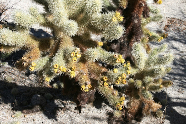
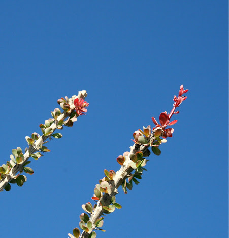
1/6/2013
Topic:
Subject: A few Winter Blooms
waning moon
|
Just missed the Cholla bloom
Chuparosa

Desert Lavender

My Favorite Ocatillo

Bloom
Yellow Chuparosa

Yucca Condo
 |
1/7/2013
Topic:
The Slot and The Wind Caves
waning moon
|
It is very nice, my daughter took photos last time down, some look identical to yours. All I do is drive, drop them all off at the top and pick them up at the bottom, then drive North out Borrego Mtn. Wash.
One of my Daughters

A daredevil grandson

Flying Buttress

A Friendly P. phrynosoma calidiarium

View of the wind caves with Santa Rosa's in the back ground, just before you go over the drop off into Borrego Mtn. (I have to admit in younger years I went up the downhill slope before it was marked)

"YonHe" guarding the entrance to Borrego Mtn. from San Felipe, not sure if you made it this far North (I did not take the photo, I was forced to stop by one of the females in the group)

Fonts from mouth of Borrego Mtn where it empties into San Filipe

Another nice Family trip |
1/7/2013
Topic:
7 Days in Anza Borrego Desert State Park
waning moon
|
So very nice Daren, the Inner Pasture, last time I was up there it had water, good water. Sad to see it has been abandoned, but open grazing stopped some time ago in ABD, no need to maintain it I guess (I saw the same thing happen on the Arizona strip, where cattle had to be removed for environmental reasons, waterworks left to vandals). It seems so little time ago that ferrel cattle and burro tracks were everywhere in ABD, all the way out to Carrizo Marsh. But it is so nice to see the Borrego in your photos, more than an even exchange I think. I can see cattle at the grocery store cold case anytime I want.
Highly unlikely I will ever walk those trails again. So more photos |
1/8/2013
Topic:
7 Days in Anza Borrego Desert State Park
waning moon
|
It is so beautiful, and all I am is more envious, lovely photos, still trying to figure out how to make mine larger, any advise?
dsefcik wrote:
One of the two steel troughs in Canebrake still has drops of water. The trough bottom is broken so it collects no water but the pipe from the spring still drips and could be a water source if needed. I know of another cement trough in Canebrake that is dry but water is nearby. Gorgeous area and always a pleasure to go hike thru. I plan to revisit the area many more times.
waning moon wrote:
So very nice Daren, the Inner Pasture, last time I was up there it had water, good water. Sad to see it has been abandoned, but open grazing stopped some time ago in ABD, no need to maintain it I guess (I saw the same thing happen on the Arizona strip, where cattle had to be removed for environmental reasons, waterworks left to vandals). It seems so little time ago that ferrel cattle and burro tracks were everywhere in ABD, all the way out to Carrizo Marsh. But it is so nice to see the Borrego in your photos, more than an even exchange I think. I can see cattle at the grocery store cold case anytime I want.
Highly unlikely I will ever walk those trails again. So more photos |
1/9/2013
Topic:
Subject: A few Winter Blooms
waning moon
|
David,
I wish for a wonderful bloom as well, there are so many species that will only appear once, in five, ten, fifteen years and longer, I very much like your photo of encelia, I always look for it on rocky slopes, it brings an early spring (even though it is just a very opportunistic plant), mallow and lupine would then follow. Break a stem or flower, it will smell like sunflower.
This is a nice forum
hikerdmb wrote:
I saw some chuparosa blooming in Pinyon Wash (no pics). The creosote bushes were very green in Harper Flat (no pics). There were a few brittle bush plants with some blooms in Pinyon Wash and in Harper Flat this weekend. I am hoping for some more rain and a huge bloom this spring. But I bet everyone is wishing for that.
David
 |
1/9/2013
Topic:
7 Days in Anza Borrego Desert State Park
waning moon
|
Thank you for responding Daren,
I have an "on line" identity? that came with my google email, this allows me to upload photos (as per FAQ instructions to public domain), but I am sorry to say after that, I click and drag to post. I do not know how to link? I have tried increasing pixels, resizing in google upload etc. (was successful once), but last post was small size again until I see Bob edited, (Thank you Bob)
So I think I need a step by step, would appreciate it.
Thank you
dsefcik wrote:
waning moon wrote:
It is so beautiful, and all I am is more envious, lovely photos, still trying to figure out how to make mine larger, any advise? That depends on how you host the photos. Usually you have size options to link to them with, where do you upload them to? |
1/13/2013
Topic:
Hurricane Kathleen 1976
waning moon
|
Well I beat these uploaded photos up enough trying to get the missing ones to post and also larger, ended up losing another in the process.
There was a post a while back which mention Hurricane Kathleen which came up the Gulf and inundated Ocatillo in 1976. I remember going down and my wife taking a number of photos, after rummaging through boxes they where found (in very poor condition). Photos were entirely brown a touch of purple, essentially sepia, I ran them through a scanner and corrected and then another program to enhance even more. Some came out, here are a few
West of old Millers


Looking SW up Devil's

Coyote Wells looking South towards Yuha Buttes

Looking West, Ocatillo in the background


Carrizo Wash from McCain's, I do not think this is Saccatone though, wash is clean cut

edited by waning moon on 1/15/2013
edited by waning moon on 1/15/2013
edited by waning moon on 1/15/2013
edited by surfponto on 1/18/2013
edited by surfponto on 1/18/2013
edited by surfponto on 1/18/2013 |
1/17/2013
Topic:
Hurricane Kathleen 1976
waning moon
|
OK last try, the google program is not "Picasa", I venture into the WEB only as far as it suits my interests, do not trust it as far as I can throw it. Something, "Google Chrome" has been offered, but again I never upgrade or download, maybe that is where Picasa is? My Google album is public (cannot believe I did this but I have very good firewalls) still ABDF will not accept my copy and paste URL in attach files. So here goes another click and drag that was somewhat successful before.
Old Millers
Looking up Devils or as I see it now called Myers creek
Washout
Coyote Wells looking South to Yuha Buttes (when Coyote Wells was actually a place)
Railroad tracks
Railroad tracks with Ocatillo in the background
Carrizo Wash from McCains, clean cut from storm, I do not think this is Saccatone (this was before McCains was closed)
I happened to be to the top of San Pedro Matirs shortly after the Hurricane as well, huge pines (Jefferies) as large as Ponderosa's not like our drawf Laguna Mtn. Jefferries were pulled up as so many twigs and tossed around. At La Grulla the creeks were washed clean, 6" fingerling trout all that remained (and knowing that PETA and the Sierra Club will now be after me, I still ate them) no roads back then, 35 miles on a horse to the top in one day.
edited by waning moon on 1/17/2013 |
1/31/2013
Topic:
Hurricane Kathleen 1976
waning moon
|
Thanks for fixing the other photos Bob,
And here I try again, I played with this photo a bit and it came out pretty good, shows the slides running down the canyon walls from the railroad track, again right after hurricane.

Also some photos from La Grulla after the hurricane, pond and creeks washed out. Top of San Pedro Matirs


One of Ida's grandsons with a trout string, I think he was around 13 and a handfull, enough said. Any way we caught quite a few, seeing them now, a little larger than I remember.

Our camp, wife took the photos, her parents and her brother, Tim the grandson and one or two unidentified who I think were Condor people we ran into. I am in the very back center of the photo, blue shirt gray hat.

A little off subject but all related to the Great Hurricane of '76
surfponto wrote:
Hi again
Was able to enlarge the pics on your original post. Some still show up missing but the majority are there.
They are great pictures!
Bob
waning moon wrote:
OK last try, the google program is not "Picasa", I venture into the WEB only as far as it suits my interests, do not trust it as far as I can throw it. Something, "Google Chrome" has been offered, but again I never upgrade or download, maybe that is where Picasa is? My Google album is public (cannot believe I did this but I have very good firewalls) still ABDF will not accept my copy and paste URL in attach files. So here goes another click and drag that was somewhat successful before.
Old Millers
Looking up Devils or as I see it now called Myers creek
Washout
Coyote Wells looking South to Yuha Buttes (when Coyote Wells was actually a place)
Railroad tracks
Railroad tracks with Ocatillo in the background
Carrizo Wash from McCains, clean cut from storm, I do not think this is Saccatone (this was before McCains was closed)
I happened to be to the top of San Pedro Matirs shortly after the Hurricane as well, huge pines (Jefferies) as large as Ponderosa's not like our drawf Laguna Mtn. Jefferries were pulled up as so many twigs and tossed around. At La Grulla the creeks were washed clean, 6" fingerling trout all that remained (and knowing that PETA and the Sierra Club will now be after me, I still ate them) no roads back then, 35 miles on a horse to the top in one day.
edited by waning moon on 1/17/2013
edited by surfponto on 2/1/2013
edited by surfponto on 2/1/2013 |
2/10/2013
Topic:
Subject: Grapevine Cyn Side Trip
waning moon
|
Grapevine Canyon, Angelina Spring, the landmark Cottonwood now burned, I remember hearing about the fire in
San Felipe but did not know it jumped the ridge. Very start contrast to the lush creek bed it was. I did not see any
flowing water in the bed and understand it stopped some time ago. I would go gold panning in the creek probably
around 1972 or so, Northern end of canyon South of the WW ranch, small gold mine some ways up the canyon
as you climb out NW. Water ran from ranch to almost the mouth of Grapevine where it dived into the gravel. The
road led right down the creek then and was just a pleasent drive.

More of Angelina, very hot fire burned out the understory and the trees save a few. As sad as it looks it is a phase,
plant species never seen except after a fire will appear this spring, then grasses (most non-native), then seed crop,
low brush in the next two seasons

Here is a large milling site, indicative of permanent habitation, I have never read an Archeological survey of this site
so not sure what village, since there was a large Kamia village in San Felipe maybe the same here, but Grapevine
leads up to Warners so always wonder if it was Cupeno.


Closer to the mouth where Grapevine empties into San Felipe, felt eyes watching, and of course I did not have the
telephoto lens on and no time to change, a beautiful herd of Borrego or more properly Cimarron.Never saw the
Alpha Ram, other side of ridge, but 5-6 males and ewes, some looked pregnant, all healthy.


Spending time in many side canyons now, as long as we can drive in and out, Flu hit me hard, 3 days in the hospital
and a couple of weeks down and out, this when I was just starting to feel good and considering some short hikes.
Bob you must be proud of me, full size photos all by myself, I think I almost have it down
edited by waning moon on 2/10/2013
edited by waning moon on 2/10/2013
edited by waning moon on 2/10/2013 |
2/10/2013
Topic:
Subject: Grapevine Cyn Side Trip
waning moon
|
Yes, lucky, they were a distance away and did not spook, nice to see a small come back in this area, numbers are falling further North, Coyote Canyon and vicinity due to Mountain Lion predidation.
I saw Culp burned, going up and down the grade, how far down did it get? This is one of the hikes I had wanted to do, all down hill to the grove, but a ways to parking.
dsefcik wrote:
Nice, you saw some BHS. I was out in Culp Valley last week and it is pretty burned up. |
3/3/2013
Topic:
Anza Borrego March 3rd Wild Flower Report
waning moon
|
Some blooms and almost blooms from some quite varied terrain


Probably another 2 to 3 weeks
edited by waning moon on 3/3/2013 |
3/4/2013
Topic:
Tracking Sheep
waning moon
|
One maybe two days

Fresh Scat

Fresh tracks

Sheep

There is an old Ram lying down in the lower right corner under the Ironwood

Profiles please

Very old (former?) Alpha Ram with large horns standing up, 8" broken off the left

I felt his age through a weary gaze, soon to run the ridge forever |
3/7/2013
Topic:
Post your Anza Borrego Sunrise Photo
waning moon
|
My submission, please prepare prize money in small denomination unmarked bills

sunrise North towards Fonts form our lounge chairs
 |
3/19/2013
Topic:
Anza Borrego Peak Wildflower Bloom For 2013
waning moon
|
TR wrote:
Where do you think you should go to see the wildflowers?
TR,
A few suggestions

Dune Primrose - Ancient Beach Line

Desert Aster - Fishcreek

Desert Holly - Fishcreek

Ground Cherry - Fishcreek

Verbena - Fishcreek

Maguay - Hapaha

Mojave Yucca - Hapaha

Beavertail - Harper

Barrel - Harper

Dark Efed Primrose - Borrego

Lupine and Desert Poppy - Harper

Desert Salvia - Harper

Bigelow Monkey Flower - Harper

Whispering Bells - Borrego

Desert Chickory - Borrego

Desert Dandelion and Pincushion - Borrego

Phalicia - Borrego
Blooming now
edited by waning moon on 3/21/2013 |
3/27/2013
Topic:
West Mesa and Ancient Lake Cahuilla
waning moon
|
Tom,
This is Fish Creek Beach and Dunes, "Ancient Beach Line" extensive long term Cahuilla village site, still hundreds of shards, chip and flake throughout the area. When I first started visiting, 1966 or 67, there were still metates and manos buried in the dunes, picked up a few beautiful wonderstone (rhyolite) and agate arrowheads mostly laying on the mud flats. I theorize bow fishing and waterfowl.
I do not know how far West you made it but it looks like your photos are just past the Gyp railroad trestles? where Fish Creek and Carizzo wash join?


 |
4/1/2013
Topic:
Rainbow Wash
waning moon
|
Nice drive up Rainbow Wash to base of Fonts.

Been a while, do not remember it that narrow

Eriogonum Inflatum (one of my favorites) "trumpet flower" I have some very large dried ones form the Mojave Desert in a vase

Native Gypsum sparkling over the mud hills

Looking South at the Pinyons, you do not realize the elevation gain

Iron mud concretion, let's see, a head, spine and ribs, Paleontologist time

Headed out the way you come in, wash has one place that is very tight, couple of S bends

Well the FJ was just a little too wide and a little too stock, heard a little grind thought it was a tire slip, and I bent the plastic.

I finally looked underneath the FJ from my desert travels, somehow this is supposed to be a skid plate

Bottom of radiator completely exposed as well, time for aircraft aluminum |
4/1/2013
Topic:
Rattlesnake Spring / Pyramid Peak
waning moon
|
Wondefull hike / photos Daren, very old Ram, looks like it died in there, last refuge.
On the Cahuilla Desert, ABF is bringing it into the park, area North of Ocatillo Wells Vec Rec to about Traverntine Rock and from the San Diego / Imperial County Line East to Salton Sea. Truckhaven hills area, TMIReservation, Wonderstone, Rosa's etc
dsefcik wrote:
hikerdmb wrote:
I love the photo of the skull and bones under the boulder. Great shot. Is that the vertebrae in the photo of the small sheep carcass? Yep..looked like it still had some dried flesh on it. |
4/1/2013
Topic:
Indio Fish Traps and SSTB
waning moon
|
Incredibly interesting and surealistic photos, how out of touch I am, did not know base was shut down and abandoned, now another place I have to go. I have not see photos of the traps that well done. Shame about the graffiti, last time I drove through grapes were being planted up and over sand dune behind Travertine rock, so much is being lost
[+quote=tommy750]Jim (ziphius) wrote:
Great photos and tour Tommy. What camera are you using? That digitate petroglyph took a moment to take form for me. Thanks for finding my jeep, forgot where I had parked it. 
Still using my 2008 Nikon D300. Just had the shutter replaced for $250 this month after only 46K shutter releases. Supposed to last 100K but cant' really say I've been gentle with it. Those petroglyphs were pretty hard to see and the pics were tweaked a lot in photoshop to even show as much as they do.
That jeep was pretty funny. We all walked around it knowing it was probably a vehicle but not able to find a clearly discernible part that would prove it. More like a jeep rust mark! That part of the base was flooded for quite a few years when the Salton Sea level was a lot higher after Kathleen and Doreen. Your jeep is at -233 ft and the max sea level was -195 ft after the storms. |
4/1/2013
Topic:
West Mesa and Ancient Lake Cahuilla
waning moon
|
Tom,
The photos are from a month or two ago, while I was out photographing wildflowers. The area has changed greatly since I first saw it, heavily used for offroad, drive right through the old camps, full on morons. The area is semi closed now, vehicle travel on established trails only, almost no one goes there anymore. I usually fill a 30 gal trash bag everytime I visit and could continue until I am dead and never make a dent. Sad
When I camped there we would be gone all day, to Carrizo Stage Station following the Overland Stage route on West to Palm Ssprings and back, or the Superstions, or shell beds NW of Plaster City
Well enough, rememberances, doubt you could make that run with Rangers in the Air now
tommy750 wrote:
waning moon wrote:
Tom,
This is Fish Creek Beach and Dunes, "Ancient Beach Line" extensive long terrm Cahuilla village site, still hundreds of shards, chip and flake throughout the area. When I first started visiting, 1966 or 67, there were still metates and manos buried in the dunes, picked up a few beautiful wonderstone (rhyolite) and agate arrowheads mostly laying on the mud flats. I theorize bow fishing and waterfowl.
I do not know how far West you made it but it looks like your photos are just past the Gyp railroad trestles? where Fish Creek and Carizzo wash join?
Thanks for the pics. Haven't been that far North yet to see the village site. Definitely want to head up that way. When was the last time you were out there? Still look about the same?
The Cahuilla beach I walked on is between Fish Creek Mts. and Superstition Hills. Here's a screen shot from Google Earth. Tom
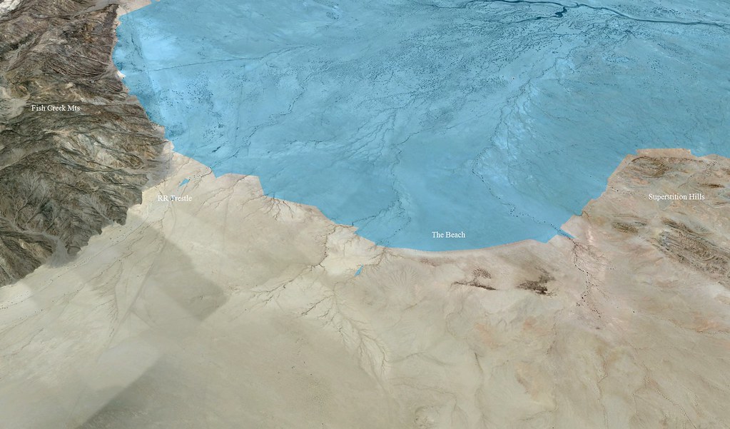
The Beach by tomteske, on Flickr |
4/1/2013
Topic:
4 Day Backpack in Rockhouse Canyon / Dawns Peak
waning moon
|
As usual beautiful trip and photos, I took some flower photos this weekend and also caught insects enjoying their bloom as much as I. |
5/27/2013
Topic:
Subject: Late May
waning moon
|

mescal

willow

mescal


ironwood


white sage

catclaw


white pencil

red pencil |
5/28/2013
Topic:
Subject: Late May
waning moon
|
dsefcik wrote:
Nice...I noticed lots of stuff blooming this weekend in Collins Valley. Where did you take the moon photo? I did not see much of a red moon.
On the Southern bluffs overlooking San Felipe wash, a few miles from "Texas Dip". It was windy Saturday, dozed off, woke up in the middle of the night and saw a red glow. Got the camera, took many shoots but without a tripod and the wind, no chance for a good exposure, still a few came out, a little blurry but definately magical. |
1/4/2014
Topic:
Calcite Mine
waning moon
|

Calcite Vein

Slit Trench following vein

Calcite Mine

Salton Sea

Sphinx on way up

Mine Tailings

Badlands, San Felipe Wash, Borrego Mtn in foreground
Set up for the winter season a couple months ago, taking quite a few trips including this drive up to Calcite Mine, been a long time, very nice. No one else up there except two young hikers just heading down, spent afternoon peacefully walking around.
See everyone else has been busy, enjoy the postings |
1/6/2014
Topic:
Calcite Mine
waning moon
|
Hello Nolan,
I would like to have gone up to the other mine, but would not make it back out, too far and never make the climb back up. But I do not need to, your photos are beautiful, love the crystals, looks like a couple of spars are in the cluster, people must be chipping away at it still.
I plan on going back sometime, but by palm canyon, side trip up North fork to see sheep tanks again, then maybe to the upper mine by the wash, I keep making plans.
And to all who expressed charitable comments on my photography. Thank you, I know they are just tourist grade, never really took photos until I stumbled upon this forum, still learning, As I have expressed before love all of your posts/photos, fantastic hike reports, you guys are the pros, get to experience places I will never make it to.
Thanks |
1/31/2014
Topic:
Fish Creek New Years 2013
waning moon
|
Daren, our paths may have crossed, I was up at the spring, a favorite place although a bit crowed now. I planned this for some time, quite apprehensive, my first real hike (I put on a day pack), to any of you this is a casual stroll, to me it took 3 hours. Packed up enough water and E supplies for 2 days in case I went down, There was a black Toyota? maybe Nissan at the old tank what you call the parking area, I never went up that far after seeing it, chose to go over the east ridge and go up wash, I was spent by the time I got to the bottom of the saddle. Plants/friends on the way
Lavender

Holly

Aster

Bladder pod

Encelia

Was not prepared for this, water tanks? tired and somewhat dissorientated, never this this before

gurgler? water trough, in dissrepair needed serious work though both alive and dead bees clogging it, loved it, I could not clean it out, running on empty

Interesting catch basin above, not well designed and silted over, but tanks were full. again if I had a shovel and any energy left I would have dug it out

tanks from above, whale in background

old catch basin I remember

Seep/spring now dry

On way down climbed only soft ground knoll with grass, sleeping circle still there bu rocks pushed around. Rested quite awhile here, number one it overlooks wash from Hapaha to Harper, great game trail and I had severe angina, got into my nitrostat.

chip still there. hunting camp, game headed for water

sleeping circle at bottom of saddle

Top of saddle, road in to spring, wash I came up to the East, went down this way, I could not worry about running into the black truck occupants who I thought were camping in the tank. Got down to bottom, truck still there but no one around, but I picked up the same size 12 new tread hiking boot track that I saw going over to Harper in the wash.

I remember first going up to spring when I was very young, I followed the pipe, could run on boulder tops then, what I called dancing, now I go a bit slower
edited by waning moon on 1/31/2014 |